Showing 1773 items
matching maps and plans
-
 Bacchus Marsh & District Historical Society
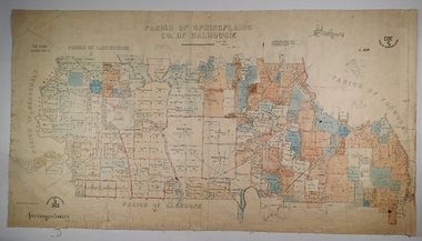
Map, Myrniong Parish Map, County of Bourke, 1882
A single page paper map showing the map for the Parish of Myrniong in the County of Bourke. A cadastral map showing parish boundaries and land ownership. The map is pasted into a bound volume containing 76 maps or plans in total. High resolution digital image stored on BMDHS computer network. Photo-lithographed at the Department of Lands and Survey, Melbourne by J. Noone, 17.7.82myrniong parish plan, myrniong parish maps, bacchus marsh region parish plans -
 Warrnambool and District Historical Society Inc.
Letter book 13, 1920
This letter book contains letters, sketch maps and plans and dates from 1920 to 1923. It came from the office of John William Crawley Junior, an engineer, architect and surveyor in private practice in Warrnambool and also the engineer for the Shire of Warrnambool from 1895 to 1935. His father, brother and son were also engineers and worked in that capacity or as the Shire Secretary for the Shire of Warrnambool, with the Crawley family recording a total of 132 years of service to the Shire. The letter book was passed onto John Crawley’s son, Rolf, the engineer for the Shire of Warrnambool from 1935 to 1968. It then came into the possession of Michael Hand who took over the private surveying business on Rolf Crawley in Warrnambool. The Warrnambool and District Historical Society acquired the letter book, along with several other Crawley ledgers, from the estate of Michael Hand. This letter book is of considerable significance as it contains letters and maps drawn up by John William Crawley, an engineer in the Shire of Warrnambool for 40 years. It will be very useful for researchers.This is a dark red hard- cover letter book of 1001 pages. The book has brown binding on the corners of the cover and on the spine. There is gold lettering on the spine. The inside of the cover is lined with a multi-coloured mottled pattern. The cover is stained and scuffed. The pages contain handwritten letters, sketch maps and plans and an alphabetical index at the front. There are three loose pages. There is a mauve stamp on the first page.‘Letter Book 1920 to 1923’ ‘Rolf. L. Crawley Civil Engineer, Drainage and Water Supply Engineer, Licensed Surveyor, Registered Architect, Warrnambool’ john william crawley junior, warrnambool, rolf crawley, warrnambool, shire of warrnambool -
 Ringwood and District Historical Society
Flyer, Land Sale Brochure, Heathmont Estate, Vic. - circa 1960
Advertisement for sale of residential lots - Heathmont Estate, opposite Heathmont Railway Station, with map and locality plan.Subdivision includes Canterbury Road, Royal Avenue, Coleman Street, Stoda Street, Herman Street, and Campbell Street. Agent - A.W. Dickson, opposite Station, Ringwood. Phone WU6007. -
 Bendigo Military Museum
Album - Photographic Identification Guide (PIG) of the Gove Penisula (Sic) Peninsula, Army Topographic Support Establishment, May 1997
These photographs and a video were captured in May 1997 by Jeff Ruiz and Wayne Walsh from the Army Topographic Support Establishment (ATSE). The video taken onboard an aircraft has not been located at this time. A flight line diagram showing the path of the aircraft taking the video is enclosed in the album. The Army Topographic Support Establishment was created to perform some of the functions of the Army Survey Regiment.A Large Purple covered Album with gold dots containing maps, plans and coloured photographs of Gove Peninsula.royal australian survey corps, rasvy, fortuna, army survey regiment, army svy regt, asr, atse -
 Federation University Historical Collection
Book, Dr Ian D. Clark et al, Pyrenees Shire, University of Ballarat, Tourism Planning and Development
The Themes that have been most prevalent in the Shire are: Major Mitchell's Impact Pastoral Runs in the Pyrenees Shire Aboriginal History Gold Rush Era Chinese History Wine ProductionPink soft covered book of 35 pages with fifteen appendices. It includes pull out maps and plans. nature based tourism, accommodation, restaurants, transport, attractions, funding, community interest, production development plan, trevor peek, geoffrey gray, djadja wurrung aboriginal clan, the australian tourism commission, tourism victoria, avoca, beaufort, snake valley, amphitheatre, landsborough, lexton, elmhurst, moonambel, mt cole, redbank, mount lonarch, lake goldsmith, st arnaud, lamplough, buangor, natte yallock, navarre/barkly, percydale -
 Bendigo Historical Society Inc.
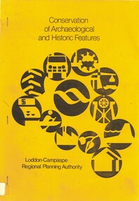
Book - CONSERVATION OF ARCHAEOLOGICAL AND HISTORIC FEATURES, 1977
Conservation of archaeological and historic features Loddon-Campaspe Regional Planning Authority. 51 pages, with photos, and maps.Loddon Campaspe Regional Planning Authoritybendigo, buildings, historic and archaeological, heritage, history, buildings, historic features, heritage features -
Bendigo Historical Society Inc.
Map - SANDHURST SHEET 2, No date visible
Map:Sandhurst, County of Bendigo Sheet 2. Parish plan, Eaglehawk. ( number 200 in Map Cupboard 1)map, bendigo, city streets, sandhurst -
 Bendigo Tramways (managed by the Bendigo Heritage Attractions)
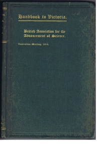
Reference Book, Albert J. Mullett, Government Printer, Melbourne, Handbook to Victoria- British Association for the Advancement of Science, CIRCA 1914
1914 Handbook prepared for the members of the "British Association for the advancement of science" on the occasion of their visit to Victoria, under the direction of the Victorian Executive Committee. Hard covered green handbook, gold leaf lettering. Printed text with Illustrations, Maps, Plans and Diagrams.Stamped: "WITH THE COMPLEMENTS OF THE GOVERNMENT STATIST." victoria, 1914, education, population, immigration, mining, geology, land, law, government, forestry, maps, public works. -
 Bendigo Historical Society Inc.
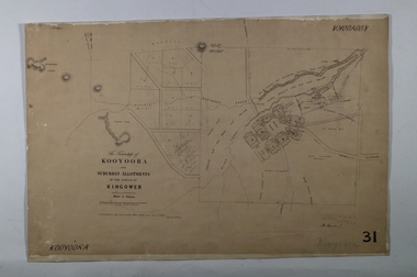
Map - KOOYOORA, July 23rd 1857
Map: The Township of Kooyoora and suburban allotments in the Parish of Kingower. This plan has been applied to a newer backingmap, township, kooyoora, allotments, parish of kingower -
University of Melbourne, Burnley Campus Archives
Plan, Burnley College Site, c. 1970 - 2001
Miscellaneous plans of the Burnley site with enlargements of sections. Roughly sorted. Different periods. Includes a map of Kew, and part of plan of Charman Ave., Emerald. Annotated plan of area of glass houses and chicken test pens ((1970 - 80?)burnley college, gardens, college buildings, kew, emerald -
 Bacchus Marsh & District Historical Society
Map, Trentham Parish Map 1905 Copy 1
A single page paper map showing the map for the Parish of Trentham in the Counties of Dalhousie and Bourke. A cadastral map showing parish boundaries and land ownership. The map is pasted into a bound volume containing 76 maps or plans in total. High resolution digital image stored on BMDHS computer network. Photo-lithographed at the Department of Lands and Survey, Melbourne by T.F. McGauran 22.3.05 trentham parish maps, trentham parish plan, bacchus marsh region parish plans -
 Whitehorse Historical Society Inc.
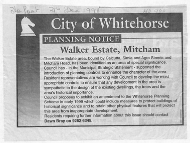
Document - Article, Planning Notice, 21/12/1998 12:00:00 AM
... Maps ...Planning Notice concerning the Walker Estate in Mitcham. Amendment to the Whitehorse Planning Scheme could include protection of buildings of historical significance, proposed early in 1999. Includes map of area.maps, walker estate, mitcham road, mitcham, calcutta street, mitcham, delhi street, mitcham, agra street, mitcham, simla street, mitcham, benares street, mitcham, meerut street, mitcham, the strand, mitcham, percy street, mitcham, stanley grove, mitcham, bray, dawn -
Stawell Historical Society Inc
Map, Shire of Stawell, Shire of Stawell Interim development Order, C 1930
Planning MapColoured Map of Stawell Shire showing Zoning AreasGuttering Haskings & Davey Pty Ltd Division of Urban and Environmental Planninglocal development -
Bendigo Historical Society Inc.
Map - CAMPBELL COLLECTION: BENDIGO AND DISTRICT MAPS, 18-6 29
Map. Longlea, Parishes of Axedale and Eppalock, scale 20 chains to 1 inch, total area 2372 acres. Prepared from Assessment Plan and Parish Plan by H.A. Darby18-6-29., Wondong, Heathcote and Sandhurst line (Railway). (number 386 in map cupboard 1)H.A.Darbymap, bendigo, agricultural lands -
Bendigo Historical Society Inc.
Map - CRAVEN'S ALLOTMENTS , NEW CHUM, No date visible
Map: Craven's Allotments, New Chum. Hand Draughted plan showng the corner of McKenzie and Rose streets Bendigo.map, bendigo, allotments, cravens allotments, new chum -
 Whitehorse Historical Society Inc.
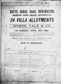
Document, Hampton Court Estate
Plan of subdivision Hampton Court EstatePlan of subdivision Hampton Court Estate Whitehorse Road, Nunawading 1882. Original in Vale Maps LaTrobe LibraryPlan of subdivision Hampton Court Estate hampton court estate, byrne vale & co. -
 Port Fairy Historical Society Museum and Archives
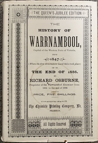
Book, Richard Osburne, The history of Warrnambool, capital of the western ports of Victoria, from 1847 (when the first government land sales took place) up to the end of 1886, 1980
The history of Warrnambool, capital of the western ports of Victoria, from 1847 (when the first government land sales took place) up to the end of 1886 / by Richard Osburne Other Authors, Fraser, Malcolm, 1930-2015, (author of introduction, etc.) Tylee Memorial Collection368 pages, unnumbered and folded leaves of plates : illustrations (some colour), maps, portraits, plans ; 19 cmnon-fictionThe history of Warrnambool, capital of the western ports of Victoria, from 1847 (when the first government land sales took place) up to the end of 1886 / by Richard Osburne Other Authors, Fraser, Malcolm, 1930-2015, (author of introduction, etc.) Tylee Memorial Collectionvictoria. warrnambool, 1847-1886. facsimiles, government policy - initial period and protectionism., settlement and contacts - 19th century., mining industry - gold., race relations - violent - massacres, religions - christianity - missions., warrnambool (vic.) -- history., framlingham / purnim (w vic sj54-11), demography - census data, book -
Bendigo Historical Society Inc.
Map - BENDIGO PARISH PLAN
BHS CollectionBendigo Parish Plan Central Bendigo. Canvas with Canvas typed edges. Taken from George Black's maps -
University of Melbourne, Burnley Campus Archives
Book - Report, E.B. Littlejohn, Victoria 1944 State Regional Boundaries Committee Report on Regional Boundaries, 1944
See paper catalogue for complete contents. Item formerly property of E.B. LittlejohnReport includes maps of Regions for Planning and Development, geographical, weather, power, water resources, crops, livestock, etc.e.b. littlejohn, planning, development, regions -
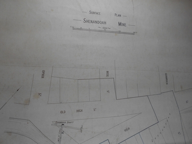 Bendigo Historical Society Inc.
Administrative record - Shenandoah Mine Surface plan
Draftsman's drawing Shenandoah Mine Surface Plan Map. Forms part of the Margaret Roberts Collection of mining records.bendigo, margaret roberts, gold, map, mine, shendandoah mine -
 Bendigo Historical Society Inc.
Map - SPRING PLAINS, Examined 31/01/1876
Map: Parish of Springplains, County of Dalhousie. Parish plan June 1874 A.D. Scott Examined E.D. 4.7.74 Additions made March 1877 Written in blue " See new plan."map, dalhousie, parish plan, spring plains, a. d. scott -
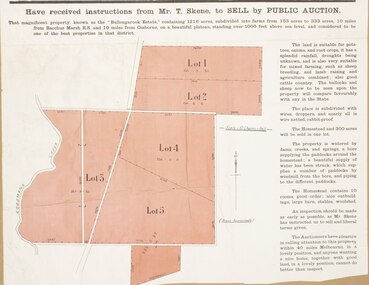 Bacchus Marsh & District Historical Society
Map, Bullengarook Estate Property Sale. 1911
Bullengarook is a locality located 19 kilometers north of Bacchus Marsh. Pastoral leases for European colonists were granted to people for this area from around the 1840s.The Bullengarook Estate was part of these early pastoral holdings. By the 1900s the property had been owned by the Skene family for a number of years. In early 1911 the property then consisting of 300 acres and the homestead upon it was offered for sale in one lot. It appears however that the sale of the property did not go through in 1911. It was later leased by Thomas Skene to a Mr Coutts in 1915 and ultimately and at a later stage the property was sold by the Skene family.A single page paper map showing land allotments for sale from the Bullengarook Estate. The map is pasted into a bound volume containing 76 maps or plans in total. High resolution digital image stored on BMDHS computer network. land sales bacchus marsh, bullengarook land sales, bullengarook estate, bullengarook vic history -
Bendigo Historical Society Inc.
Map - CAMPBELL COLLECTION: BENDIGO AND DISTRICT MAPS
Map. Marong, Parishes of Marong, Lockwood and Mandurang. Scale 20 chains to an inch. Total 5106 acres. Compiled in W.P.B. from Field Survey and Parish Plans. Crusoe Reservoir to the right of map. (number 362 in map cupboard 1)map, bendigo, parish plan -
 Bacchus Marsh & District Historical Society
Map, Maddingley Township, Parish of Parwan, 1880s
This map is dated Sept. 6th 1856. However places in the township of Maddingley which did not appear until the late 1880s such as the Bacchus Marsh Railway Station and line are shown on this map in their correct locations. This suggests the map has been derived from an earlier map. An earlier date of 1843 with a surveyor's name preceding it can also be seen on the map. The map is important because it indicates the location and dimensions of early but now discontinued use of land such as the showgrounds and police paddock and a site reserved for the Church of England which was not ultimately used for a permanent church. A single page paper map showing land allotments, streets, rivers, creeks, park lands, the railway line and Bacchus Marsh railway station in the township of Maddingley. The map is pasted into a bound volume containing 76 maps or plans in total. Bottom of Map: Surveyor-General's Office, Melbourne, Sept 6th, 1856bacchus marsh victoria maps, maddingley victoria maps, land use, maddingley victoria history -
 Bacchus Marsh & District Historical Society
Map, Maddingley Township, Parish of Parwan, circa 1890s
Maddingley is a locality or township within the broader township area of Bacchus Marsh. This map is not dated. However features in Maddingley which appeared in the 1880s and 1890s are present in the map, These include the Bacchus Marsh Railway Station and the Bacchus Marsh Showgrounds. The main residential and commercial area of Maddingley is shown on this map in an area bounded by Bacchus Street, Barry Street, Griffith Street and Maddingley Road. Other streets visible are Franklin Street, Inglis Street, Labilliere Street, McCrae Street, Moore Street and part of Station Street.A single page paper map showing land allotments, streets, rivers, creeks, park lands, the railway line and Bacchus Marsh railway station in the township of Maddingley. The map is pasted into a bound volume containing 76 maps or plans in total. bacchus marsh victoria maps, maddingley victoria maps, land use, maddingley victoria history -
Bendigo Historical Society Inc.
Map - CAMPBELL COLLECTION: BENDIGO AND DISTRICT MAPS
Map. Ellesmere, Parish of Ellesmere. Scale 20 chains to 1 inch. Total area 3926 acres. Prepared in W.P.B. from A and P plans. (number 354 in map cupboard 1)map, bendigo, agricultural lands -
 Bendigo Historical Society Inc.
Map - JACK FLYNN COLLECTION: HUNTLY, 12.03.1932
Map: Township of Huntly, Parish of Huntly , County of Bendigo. Parish plan. Western and South Riding Division on Main St. (Main Northern Highway) - written in ink below name of map.BY Authority H.J. Green. Photo-Lithographed at the Dept., of Lands and Survey, Melbourne. 12.3.32map, bendigo, township, huntly -
Bendigo Historical Society Inc.
Map - PLAN OF THE BENDIGO RAILWAY YARD, Circa 1960
Map: Plan of the Bendigo Railway Yards, Scale: 80 feet to 1 inch. 1960's. (number 319 in map cupboard 1) Location unknown. Image in Mosaic images overflow.map, bendigo, railway yard, railways, rail yards, station layout -
Tarnagulla History Archive
Photocopies of historic maps - Tarnagulla region, varied
David Gordon Collection. Four photocopies in clear sleeve: (a) topographic with mines near Tarnagulla (b) Parish map ?- Tarnagulla & surrounds (c) Parish map ?- Tarnagulla & surrounds (d) Plan of Roads, Tarnagulla & Newbridge -
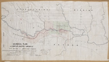 Bacchus Marsh & District Historical Society
Map, General Plan for Water Supply Works, Shire of Bacchus Marsh 1887
Debate about water supply and its planning and development took place in the Bacchus Marsh region from the 1850s through into the twentieth century. This plan was part of documentation to support an application for an additional loan of money from the Ministry of Water Supply to the Bacchus Marsh Shire Water Supply Trust. The plan includes the route of a proposed water channel in the Parwan area, and other features of water supply infrastructure such as the location of standpipes and gates are also shown on the plan.A single page paper map showing a general plan for the supply of water in the Bacchus Marsh area.The plan shows the route of the 'Main Channel' near the Werribee River and a proposed route for a Parwan Channel. The location of 'Dryden's House' near the Werribee River is also shown and the locations of land held by T. (Tom) Oliver and the Racecourse Reserve in Maddingley. Scale 40 chains to 1 inch. The plan is signed by Bacchus Marsh Shire Engineer, W.E. Standfield. The map is pasted into a bound volume containing 76 maps or plans in total. High resolution digital image stored on BMDHS computer network. General Plan of Water Supply Works in the Shire of Bacchus Marsh. Accompanying application for 2nd additional Loan. Original Waterworks district. Additional area. W.E. Standfield, 30/8/87.water supply, water supply maps, water supply bacchus marsh, irrigation, bacchus marsh victoria maps