Showing 6008 items
matching residential
-
 Bendigo Historical Society Inc.
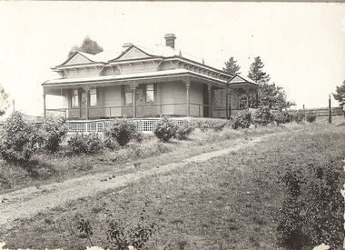
Photograph - T C WATTS & SON COLLECTION: HOUSE PHOTO, NO ADDRESS, 1927
BHS CollectionBlack and white photograph mounted on rectangular grey board. House, early Edwardian with twin gable roofline, return verandah, entry porch on RH side. Driveway up RH side, appears to situated in open area, no neighbouring houses. Photo taken for display at T.C. Watts & Son, Real Estate Agents, Mitchell Street, Bendigo. On back of photo: Deehams, £930. Dated 9 Dec 1927.Frank A. Jeffree, Bendigoplace, building, residential, stamped on back in circle ''royal historical society of victoria, t.c. watts and son -
 Bendigo Historical Society Inc.
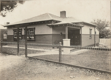
Photograph - T C WATTS & SON COLLECTION: MILLER STREET, BENDIGO, 1929
Black and white photograph mounted on rectangular grey board. House, Double fronted wood and stucco bungalow style house with entry porch on R.H.S of dwelling with small porthole tile window. Leadlight windows and door central chimney tiled roof. On front of photo: Frank A. Jeffree, Photo, Bendigo. On back of photo: Mr. Simmonds, Miller St., £875 sewered. T.C. Watts & Son, Bendigo. 12 April 1929.Frank A. Jeffree Photo Bendigobuilding, residential, miller street bendigo, t.c. watts and son, mr. simmonds -
 Bendigo Historical Society Inc.
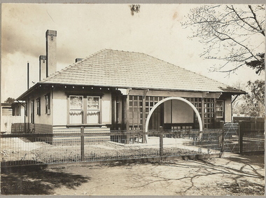
Photograph - T C WATTS & S0N COLLECTION: CORNER CONDON AND STERNBERG STREET, BENDIGO, 1928
BHS CollectionBlack and white photograph mounted on rectangular grey board. House, weatherboard and plaster, tile roof, arched entry to porch, lattice work around, woven crinkled wire fence, 3 chimneys. Sticker on front ' August 1928, Condon and Sternberg Street, £1080 sewered' Written on back ' Mannic, H.E., Condon and Sternberg St., £1080 sewered, sold' Date stamp 25 August 1928. 2012 photo of house site is attached to record.Frank A. Jeffree, Bendigoresidential, h.e. mannic, condon street, bendigo, t.c. watts and son -
 Bendigo Historical Society Inc.
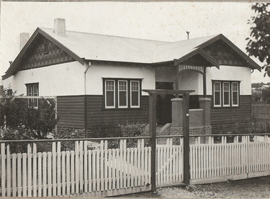
Photograph - T C WATTS & SON COLLECTION: 93 NEALE STREET, BENDIGO, 1929
BHS CollectionBlack and white photographs (2) mounted on rectangular grey board. House, weatherboard and rougheast, corrugated iron roof, 2 chimneys, decorative gables, porch with brick, render and timber pillars, wood slat fence with capping board, gate with lintel over, established garden. On back of photoboard " A. McDonell, Neale and ....... Streets, £1050 sewered' 2012 photo of house attached to record.Frank A. Jeffree, Bendigoresidential, t.c. watts and son, a. mcdonnell, neale street, bendigo -
 Bendigo Historical Society Inc.
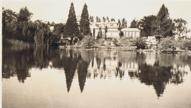
Photograph - FORTUNA COLLECTION: FORTUNA, c1940
Black and white photo. Fortuna Villa and lake, looking from far side of lake to Villa. Inscriptions/Markings: C1940. KALMA FILM SERVICE, BENDIGObuildings, residential, fortuna villa, kalma film service, bendigo -
 Victorian Aboriginal Corporation for Languages
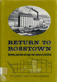
Book, D F Jowett et al, Return to Rosstown : railways, land sales and sugar beet ventures in Caulfield, 1978
The story of the attempt to establish the Rosstown industrial and residential complex in the Caulfield district, south-east of Melbourne, during the second half of the nineteenth century. The focus of the scheme was a major beet processing mill, the Rosstown Sugar Works. It also looks at the railways lines which serviced the sugar beet ventures in the Caulfield/Rosstown area.victorian history, local history, town planning, william murray ross, rosstown estate, rosstown railway -
 Bendigo Historical Society Inc.
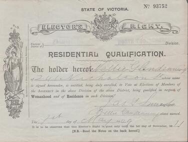
Document - ELECTOR'S RIGHT
Elector's right for the State of Victoria No. 93752 Electoral district of Flemington, North Footscray division. Residential qualification: the holder hereof Nellie Glendemming of 241 Nicholson Street is entitled to vote at elections of members of the Assembly in the above division being qualified in respect of Womanhood and of Residence in such division. Dated 1st dy of May, 1909government, state, electoral right -
 Bendigo Historical Society Inc.
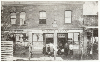
Photograph - DRESHER JEWELLER: BRIDGE ST
Phillip Dresher (1823-1906), was born in Germany and emigrated to Ireland before coming to Australia in 1852. He was married to Margaret Cosgrove. After Phillip died his son John Thomas (1873-1919) took over the business. John Thomas was also a watchman for the fire brigade.black and white photograph. Part of commercial streetscape, Level shop front, upper residential. Dresher Watchmaker Jeweller, Globe Hotel, R. hand verandah, shop not identified. Two trees, paved footpath, bench seat, small child by Dresher window. Gas light outside bar, twin doors to bar,unknown - reprintorganization, business, dresher jeweller, globe hotel, re location: j. lerk, 26.11.1999 ' globe was in mitchell street near wills street' d. walker 5.11 1999 'suggest dresher, jeweller, bridge street, bendigo close to hibernia hotel. -
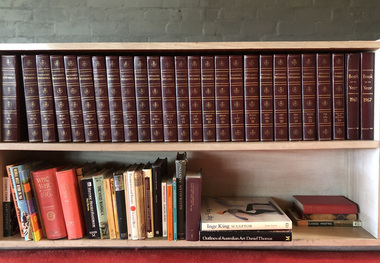 Robin Boyd Foundation
Book, Encyclopaedia Britannica, 1961
This 1961 set of the Encyclopaedia Britannica was issued to Robin Boyd in acknowledgement of his contribution, the entry on 'Residential Architecture'. It consists of seven pages of text and four black and white pages of plates that cover the history of residential architecture. There are subsections on many time periods: Primitive, Egyptian, Western Asiatic, Greek, Roman, Medieval, Renaissance, Baroque and Neoclassical, Colonial, Victorian, 20th Century and Asiatic.Robin Boyd's contribution to Volume 19 of the Encyclopedia Britannica.24 Hardcover bound volumesThere is a certificate inside the front cover of Volume 01, issued to Robin Boyd for contributing to the Encyclopedia, Volume 19.architecture, residential architecture, encyclopedia britannica, robin boyd, walsh st library, ohm2022, ohm2022_2 -
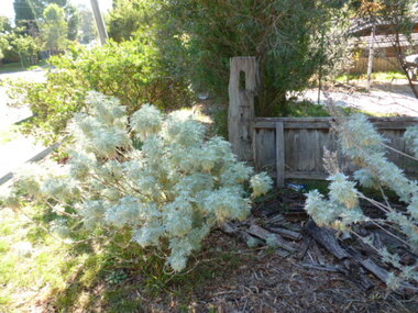 Greensborough Historical Society
Photograph - Digital image, Old Post, Mountainview Road, 02/05/2013
Photograph of old hitching post located in Mountainview Road Briar Hill. The post is located in the front garden of a residential block.Digital copy of colour photograph.mountainview road -
 Port Melbourne Historical & Preservation Society
Map, City of Port Melbourne. Parishes of melbourne South. Doutta Galla, c. 1930
City of Port Melbourne. Parishes of Melbourne South. Doutta Galla Copy of map circa 1930, showing Port Melbourne, Station and Town piers. Map is black on white paper with numbered red dots on most residential blocks. 1876 written in ballpoint on bottom - possibly date of first edition, before later additions.built environment, engineering department - city of port melbourne -
University of Melbourne, Burnley Campus Archives
Newspaper - Newspaper Cutting, The Leader, Horticultural Gardens and School, 1896
Copy of article in "The Leader" (Melbourne) ("by our special reporter") on 25 January, 1896 p13. Discussion of advantages of the course at the School of Horticulture including free tuition, non-residential. Currently 18 students. Practical tuition by Mr Neilson and scientific by Mr McAlpine. Long description of subjects studied and method of growing fruit trees.the leader, school of horticulture, mr neilson, mr mcalpine, subjects, subject descriptions, fruit tree growing, students -
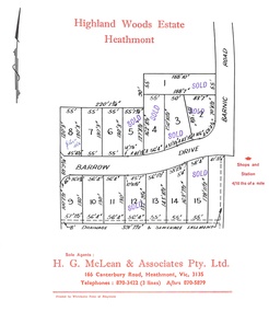 Ringwood and District Historical Society
Document, Subdivision Plan - Highland Woods Estate, Heathmont, Victoria (undated, circa 1968)
Map of 15 residential allotments for sale, with seven rubber-stamped SOLD and one with handwritten notation "$5650 1968". Subdivision includes Barrow Drive and Barnic Road, Heathmont. Agent - H.G. McLean & Associates Pty. Ltd., 166 Canterbury Road, Heathmont Vic., 3135, Telephones : 870-3422 A/hrs 870-5879. -
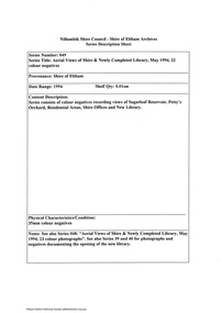 Eltham District Historical Society Inc
Document - Series Listing, Fraser Faithfull et al, Series 49: Aerial Views of Shire & Newly Completed Library, May 1994, 22 colour negatives, 2000
Series consists of colour negatives recording views of Sugarloaf Reservoir, Petty's Orchard, Residential Areas, Shire Offices and New Library.shire of eltham archives, series listing -
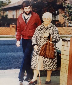 Vision Australia
Photograph - Image, Malcolm Simpson and client
O&M advisor Malcolm Simpson works with an elderly female, as she uses her white cane along a residential street.Coloured photograph of bearded man walking beside an elderly female as she uses a white caneroyal victorian institute for the blind, orientation and mobility -
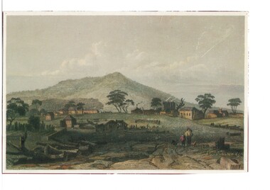 Buninyong & District Historical Society
Artwork, other - Colour reproduction of lithograph "Township of Buninyong" c1852, "Township of Buninyong" c1852
Early image of Buninyong c1852 showing evidence of land clearing, cultivation, residential and farm buildings and Mount Buninyong with tree coverBuninyong was one of the earliest settlements Victoria and became a very important place in the history of the goldrushColour reproduction of lithograph "Township of Buninyong" c1852 from the cover of "Three Times Blest"Henry Winkles Township of Buninyong c 1852 Lithograph, originally published in Montgomery Martin's "Australia" Reproduced "Three Times Blest"early settlement, henry winkles, mount buninyong, buninyong -
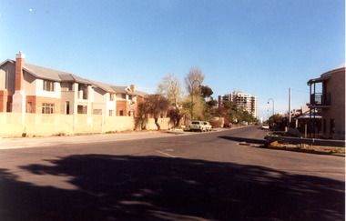 Port Melbourne Historical & Preservation Society
Photograph - Swallow Street, Port Melbourne, 1980s
Photographic images of properties in Port Melbourne. Image may have been taken by a PMHPS member or scanned from a past resident or taken for real estate sale purposes. Swallow Street; 1980s (?) photo showing new houses under construction. Part of Beacon Cove redevelopment. A New multi-storey beachfront residential complex is in backgroundbuilt environment - domestic, swallow street -
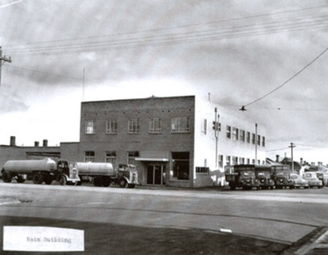 Port Melbourne Historical & Preservation Society
Photograph - Two exterior views of Woodruff's Superior Dairy, corner Bridge and Derham Streets, Port Melbourne, 1987
From the Woodruff family archives, images of Woodruff's Superior Dairy at Bridge and Derham Streets. A4 lasercopy of two exterior views of dairy a) main building b) loading platform c) newspaper article 26/11/1987 Emerald Hill Standard and St Kilda Times, referring to new residential development on Woodruff siteDetails on typed labelsindustry, business and traders - dairies, woodruff's superior dairies -
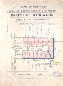 Ringwood and District Historical Society
Map - Plan of Subdivision, Parts of Crown Portions 10 and 10B Parish of Ringwood - 1958
Folded subdivision map of 15 residential allotments in McKay Court Ringwood, off Wantirna Road north of Canterbury Road. Rubber stamped by Surveyors and Chartered Engineers J.S. Watson & Associates, Mornington and South Yarra, with illegible signature dated 17/2/58. Handwritten notations indicating allotment sale names and amounts or where passed in.Scale 80 feet to an inch. -
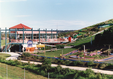 Lakes Entrance Historical Society
Photograph - Kinkuna, 2009
Kinkuna Amusement Park was opened 19 December 1987, closed 2002, building demolished or removed, land sold and subdivided into residential allotments.Copy colour photographic print showing Kinkuna Amusement Park on Princes Highway, owned by Joe and Shirley Walters. Photo shows main building and restaurant, mini golf, long taboggan on hill, garden and other attractions. Lakes Entrance Victoriaentertainment, recreation -
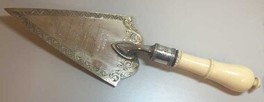 Loreto Australia and South-East Asia
Commemorative Trowel, Joseph Sleep, c.1881
Presented to the Bishop of Ballarat, Dr. James Moore, when he laid the foundation stone for the new schoolroom/residential wing at Loreto Mary's Mount. A decorative artefact manufactured by an early Ballarat jeweller. Records the early building and expansion of Mary's Mount.Silver engraved commemorative trowel with ivory handle.Presented by the Architect to The Very Rev'd J. Moore D.D.V.G. on the occasion of his laying the foundation stone fo the Loretto Convent Ballarat 8th Dec'r 1881 -
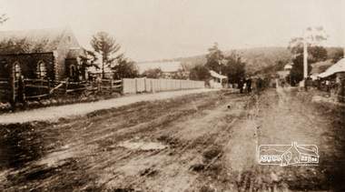 Eltham District Historical Society Inc
Photograph, Main Street, Greensborough, c.1910, 1910c
Early view of Main Street Greensborough showing the mainly residential nature of the buildings. Photographs from the collection of Peter Blackbourn, a descendant of the Chapman Stock family.Photograph copy originally located in a magnetic style album titled 'Greensborough Bypass 1990s 5' suffering significant degradation. No information contained in album or on reverse of photos except where noted. Relocated to archival photosafe storage.greensborough, main street -
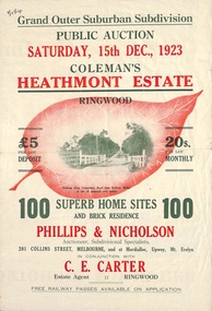 Ringwood and District Historical Society
Flyer, Land Sale Brochure, Coleman's Heathmont Estate, Ringwood, Vic. - 1923
Bi-fold advertisement for auction sale of residential sites, including photographs, map, and summary of subdivision features and local facilities. Auction date Saturday 15th December, 1923. Subsequent auction date Saturday 19th January, 1924, following previous sale stopped on account of rain. Initial newspaper advertisement (publication unknown) dated 16/11/23.Subdivision includes Bedford Road, Canterbury Road, Alvena Crescent, Leonard Street (later Royal Avenue), and Coleman Street. Agent - Phillips & Nicholson, 281 Collins Street Melbourne, (Phone) Central 10907, in conjunction with C.E. Carter, Main Street, Ringwood. Tel. Ringwood 24. -
 Ringwood and District Historical Society
Flyer, Land Sale Advertisement and auction notice - Range View Estate, Ringwood, Victoria - 1920
Advertisement for sale of 150 residential allotments with terms of sale, summary of local features and services, and map showing location and layout of subdivision within the boundary of Mitcham to the west of Ringwood, Victoria. Copy of newspaper advertisement (The Herald, Melbourne, Wednesday 3 March, 1920) refers to public auction date for Range View Estate Ringwood - Saturday, 27th March, 1920.Subdivision includes Deep Creek Road, Range View Grove, Warnes Road, Tarrangower Avenue, Prince Edward Avenue, James Avenue, and White Horse Road, Mitcham. Agents - Phillips & Nicholson, 281 Collins Street, Melbourne, Telephone Central 10907. -
 Bendigo Historical Society Inc.
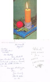
Document - DERRICK COLLECTION: CARD TO 3CV WOMEN'S TENNIS ASSOCIATION
Christmas card to 3CV Women's Tennis Association from Bendigo Residential Nursery 243 View St Bendigo. Dear Secretary, Many thanks to your President and members for the continued interest in our work, with the little children in our care. Once again thanking you, I am, yours sincerely Ethel M (Sertori ??) Hon Sec.clubs and associations, sport -
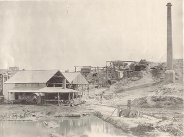 Bendigo Historical Society Inc.
Photograph - GOLD MINE BENDIGO, LAZARUS' CLAIM, C 1860's
Black and white photo: dam in foreground, building and whims on hill in background and tall chimney on rh side. Isolated ( residential ) building on hill at the rear. On front ' Batchelder/Sandhurst' ( not clear ) On back ' Gold mines, Bendigo - probably looking nw along New Chum Hill, with Lazarus' claim in foreground. Phoenix - later Old Chum Mine background'Batchelderorganization, business, lazarus' mine -
 Whitehorse Historical Society Inc.
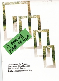
Pamphlet, A Special place to live, 1985 (addendum 1988)
A publication of the City of NunawadingA publication of the City of Nunawading explaining the regulations applying to the Special Residential (Nunawading) Zone No 5. The regulations cover proportions of land which may be built on and identifies trees which must be preserved. An addendum issued in 1988 includes a map of the area and identifies National Trust classified streets in Blackburn and the buffer areas in which less stringent regulations apply.A publication of the City of Nunawadingcity of nunawading, national trust of australia (victoria), special residential (nunawading) zone no. 5, jeffery street, blackburn, laurel grove, linum street, boongarry avenue, hill street, land use, by-laws, town planning, acacia avenue, waratah crescent -
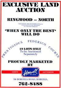 Ringwood and District Historical Society
Pamphlet, Land Auction Brochure - Federico Courts Estate, Ringwood North, Vic. Circa 1988
Bifold brochure advertising auction of 19 residential allotments on Saturday 15th October, (1988?). Brochure includes terms of sale, description of subdivision features and local facilities, with locality map. Subdivision includes Federico Court and Gilston Way, Ringwood North. Agents/Auctioneers - B.S. Howell Real Estate, 94 Boronia Road, Boronia, (Phone) 762 8488. -
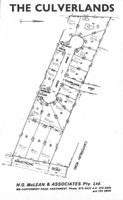 Ringwood and District Historical Society
Document, Subdivision Plan - The Culverlands Estate, Heathmont, Victoria (undated, circa 1968)
Map of residential allotments for sale, with handwritten pricing notations and some marked "Sold". Subdivision includes Culverlands Road, Swain Court, Pleasant Drive, Barbara Court, and Armstrong Road, Heathmont. Agent - H.G. McLean & Associates Pty. Ltd., 166 Canterbury Road, Heathmont Vic., 3135, Telephones : 870-3422 A/hrs 870-5879 and 729-2809. -
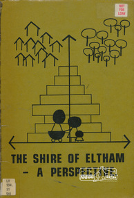 Eltham District Historical Society Inc
Book, Shire of Eltham, The Shire of Eltham - A Perspective, July 1981
This report was produced by the Shire of Eltham (Planning Department) following a population study of the Shire. It also includes other areas of general interest. The Document contents includes Present and Future - Population - Housing - Residential Lands - Social Characteristics - Development and History. Includes maps, tables and diagrams. Part 1: The Existing situation - introduction, the Shire of Eltham, physical characteristics, historical development, population growth. Characteristics of the population - size and distribution, age / sex, natural increase, migration. Socio-Economic Factors: socio-economic status, employment/workforce, education, other social factors. Housing/ building statistics: characteristics of Housing stock, current residential trends, other types of building activity. Residential Land: existing vacant lots, estimated additional lots. Part 2: The Future. Land availability, the future population.The Shire of Eltham Council resolved on publication of this report "to commend it to the ratepayers as a most valuable resource document". It provides a comprehensive statistical review of the Shire of Eltham, Victoria in 1981 with some population and development predictions for the future.Spiral bound, soft cover, includes indexBarcode and identification markings including stamped "WITHDRAWN" from Heidelberg Regional Library Serviceshire of eltham, planning, population