Showing 110542 items
matching roads
-
 Kew Historical Society Inc
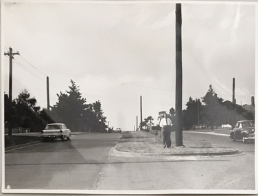
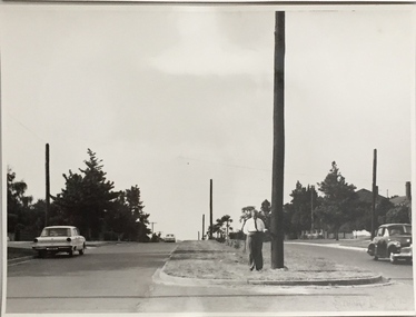
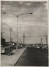
Photograph, Stuart Tompkins Studio, Electricity Supply Poles, Burke Road, Kew, 1965
Research provided by Stuart Tompkins Studio, Box Hill, into alternatives for median strip street lighting to be used in Burke Road, Kew. The photographers identified variants in different suburbs appropriate to Kew's needs.The series from which the photograph is drawn provides a snapshot by a commercial photographic studio of each named vicinity in 1965 as well as providing examples of public works infrastructure being commissioned by local government in the 1960s. The photos originally formed part of the Engineering Department's files in the City of Kew before being donated to the kew Historical Society.Electricity Supply Poles, Burke Road, Kew, 1965. This photograph of Burke Road, Kew was taken just north of Kilby and Doncaster Roads looking north. Stuart Tompkins Studio provided the photograph for the Kew City Council. In the photograph are a number of electricity supply poles that have been erected in the median strip, in addition to some new poles on each footpath. The nearest wooden pole is stated to be 13.5″ in diameter. The electricity poles in Burke Road required Kew Council to investigate comparable designs in other Melbourne municipalities. [There are three copies of this photograph in the Collection.] Typed inscription on reverse: "Electricity Supply Poles. Photographed for Kew City Council 8/2/65. No.5 Burke Road - Kew, just north of Kilby and Doncaster Roads looking north. Some of seven poles already erected in median strip. Shows also some new poles erected on each footpath. Nearest wooden pole 13 1/2" dia." Studio stamp: "Stuart Tompkins Studio. 547 Station Street, Box Hill. WX1439."stuart tompkins studio, street lighting, south road (moorabin) 1965 -
 Kew Historical Society Inc
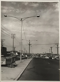
Photograph, Stuart Tompkins Studio, Electricity Supply Poles, Burke Road, Kew, 1965
Research provided by Stuart Tompkins Studio, Box Hill, into alternatives for median strip street lighting to be used in Burke Road, Kew. The photographers identified variants in different suburbs appropriate to Kew's needs.The series from which the photograph is drawn provides a snapshot by a commercial photographic studio of each named vicinity in 1965 as well as providing examples of public works infrastructure being commissioned by local government in the 1960s. The photos originally formed part of the Engineering Department's files in the City of Kew before being donated to the kew Historical Society.Electricity Supply Poles, Burke Road, Kew, 1965. This photograph of Burke Road, Kew was taken just north of Kilby and Doncaster Roads looking north. Stuart Tompkins Studio provided the photograph for the Kew City Council. In the photograph are a number of electricity supply poles that have been erected in the median strip, in addition to some new poles on each footpath. The nearest wooden pole is stated to be 13.5″ in diameter. The electricity poles in Burke Road required Kew Council to investigate comparable designs in other Melbourne municipalities. [There are three copies of this photograph in the Collection.] Typed inscription on reverse: "Electricity Supply Poles. Photographed for Kew City Council 8/2/65. No.5 Burke Road - Kew, just north of Kilby and Doncaster Roads looking north. Some of seven poles already erected in median strip. Shows also some new poles erected on each footpath. Nearest wooden pole 13 1/2" dia." Studio stamp: "Stuart Tompkins Studio. 547 Station Street, Box Hill. WX1439."stuart tompkins studio, street lighting, south road (moorabin) 1965 -
 Phillip Island and District Historical Society Inc.
Photograph
This postcard is contained in an album presented to the then Governor of Victoria, The Earl of Stradbroke, by the fathers of soldiers & returned soldiers of Phillip Island, on 16/02/1923. The history of the album is noted on Reg. No 85-00Beach Road, Cowes. Post and rail fence.The Rose Series P674. Beach Road Cowes, Phillip Island, Victorialocal history, photography, photographs, slides, film, cowes, phillip island, sepia photograph -
 Kew Historical Society Inc
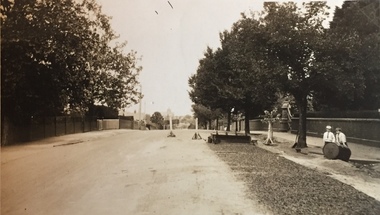
Photograph - Street Works, Studley Park Road, March 1934
Studley Park Road, like most streets in Kew, was originally a dirt road. Street works during the Great Depression included bituminising major roads in the district. This photograph of Council works originated in the City of Kew Engineers Department as a record of works undertaken. It was given to the collection by a Mrs Fisher in 1998.Well provenanced photograph of Council-funded public works in Kew during the Great Depression. Original sepia photographic positive of Studley Park Road, Kew while resurfacing of the street was taking place. The Kew Junction is just visible in the distance. Boys sitting on a drum at right. Behind them is the brick fence and front entrance to Tara Hall.Typed reverse: "B4 / Kew C.C. / Studley Park Road showing drag spread surfacing with premixed material, unrolled material on the right, March 1934"roadworks -- kew (vic.), street works -- kew (vic.), public works kew (vic.), studley park road -- kew (vic.), city of kew -- engineers department, city of kew -- public works -- great depression -- 1930s -
 Glen Eira Historical Society
Album - Album page, Bealiba Road, Circa 1972
This photograph is part of the Caulfield Historical Album 1972. This album was created in approximately 1972 as part of a project by the Caulfield Historical Society to assist in identifying buildings worthy of preservation. The album is related to a Survey the Caulfield Historical Society developed in collaboration with the National Trust of Australia (Victoria) and Caulfield City Council to identify historic buildings within the City of Caulfield that warranted the protection of a National Trust Classification. Principal photographer thought to be Trevor Hart, member of Caulfield Historical Society. Most photographs were taken between 1966-1972 with a small number of photographs being older and from unknown sources. All photographs are black and white except where stated, with 386 photographs over 198 pages.Page 38 of Photograph Album with one landscape photograph of a timber house at 87 Bealiba Road.Handwritten: Bealiba Road [top right hand corner] / 87 Bealiba Road [underneath photograph] / 38 [bottom right]trevor hart, caulfield south, bealiba road, verandah, edwardian, woodworking, towers, chimneys, weatherboard houses -
 Halls Gap & Grampians Historical Society
Photograph - B/W, C 1940s (?)
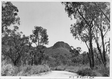
... Roads ...Photo shows unsealed section of the Dunkeld/Grampians Road, looking towards the face of Mt. Frederick.access routes, roads -
 Eltham District Historical Society Inc
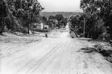
Photograph, Brougham Street, Eltham, c. Sep. 1966
... roads ...Taken from near No. 113 looking west. There is a boy walking up the road and past him a truck turning right into Bible Street. Further down the road near the EK Holden is a Eucalyptus tree with branch overhanging the road that still stands today (2021) outside No. 102.Black and white photographic printOriginally located in a Filmpro King Size Prints processing envelope $3.01 Shire of Eltham 9/9/66 and noted as Calrossie Ave area and crossed out Eltham-Yarra Glen Road, Bridge Street to Elsa Court existing conditions mid 1967brougham street, eltham, infrastructure, road construction, roads, bible street -
 City of Kingston
Photograph - Black and white, 1950
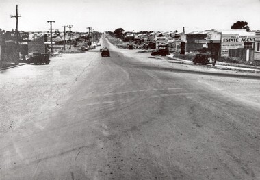
... Roads ...This photograph depicts the increasing urbanisation of a once rural area at Moorabbin.This image is one of many in the collections that focuses on either roads or the railway. The development of roads and the railway was crucial to the ongoing development of the area. Black and white photograph of South Road, Moorabbin, with Station Street to the right and Jasper Road further down to the left. Along both sides of the road are retail spaces which become homes on the left hand side, after Jasper Road.Handwritten in red ink on reverse: 80% Handwritten in blue ink on reverse: 216moorabbin, roads, cars, shopping strip, housing -
 Camberwell Historical Society
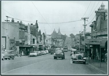
Photograph, Camberwell, Victoria, view of Burke Road and stores, c. 1950
Print of photograph looking south down Burke Road with St Johns Anglican church tower in the background. Inscription 'Camberwell, Victoria, view of Burke Road and stores c. 1950' Camberwell, Victoria, view of Burke Road and stores c. 1950camberwell -
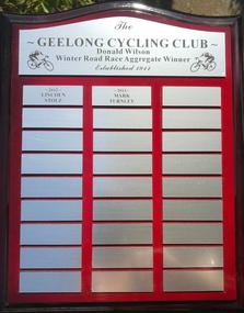 Geelong Cycling Club
Shield, 2012
This shield records the cyclists who were high achievers in road racing in the Geelong region at this time.This shield has an important place in the history of men's cycling in Geelong.A mahogany coloured rectangular wooden shield with silver plated plaques containing inscriptions of two winners of the winter road race aggregate winners for the years 2012 and 2013. There are two cyclists imprinted on the top plaque."The/Geelong Cycling Club/Donald Wilson/Winter Road Race Aggregate Winner/Established 1911/2012/Lincoln Stolz/2013/Mark Turnley"geelong cycling club; donald wilson; winter road race aggregate winner; lincoln stolz; mark turnley; -
 Kew Historical Society Inc
Photograph - Construction of the electric tram line in Riversdale Road, Surrey Hills, E.J. Dower, 1916
One of a series of photographs, taken by Edgar James Dower in the second decade of the twentieth century. Born and raised in Olinda, his family later moved to Surrey Hills. He worked as an adult as a clerk in the city office of the Metropolitan Gas Company, and in his role as a 'collector', he was able to photograph scenes including the construction of tramlines and associated buildings in Kew, Hawthorn, Camberwell and Surrey Hills. Later he established a real estate agency with his brother - the E.J. Dower Real Estate Agency, Dandenong Office.The image is an historically significant record of the development of transport infrastructure which was used to connect Victorians in the first two decades of the twentieth century. This development resulted from increases in population and the consequent extension of Melbourne's suburbs. The photographs, both individually and collectively, richly detail the labour of workers and the tools and machinery used to create and extend Melbourne's tram network in the years preceding and during World War 1.Digital copy of an original oval mounted photograph of the construction of the tracks for the new electric tramline in Riversdale Road, Surrey Hills. Annotated verso: "Preparing for electric tram line, Riversdale Road, Surrey Hills / Taken from near Warrigul [sic] Road / note Essex Road on right with picket fencing."theme --- travelling by tram, theme -- connecting victorians by transport and communications, trams -- boroondara (vic.), riversdale road -- surrey hills -
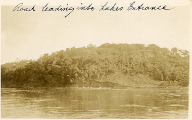 Lakes Entrance Historical Society
Postcard, 1910c
Faded black and white postcard of Jemmys Point, showing the tree covered hill, road cutting and lake in the foreground. Lakes Entrance VictoriaRoad leading into Lakes Entranceroads and streets, topography -
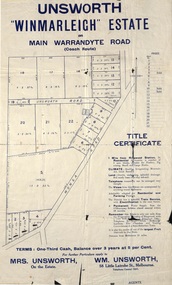 Ringwood and District Historical Society
Flyer, Land Sale Advertisement - Unsworth Winmarleigh Estate, Ringwood, Victoria - circa 1912
Advertisement and attachment for subdivision of land adjoining Warrandyte Road coach route in North Ringwood, with map showing layout of subdivision, summary of local features and services, and terms of sale. Subdivision includes Wonga Road (later Loughnan Road & Warrandyte Road), Unsworth Road, Through Road, Cross Street, and John Street. Contacts - Mrs Unsworth on the Estate or W.M. Unsworth, 58 Little Latrobe Street, Melbourne, Telephone Central 7207. -
 Ringwood and District Historical Society
Map - Plan of Subdivision, Part of Crown Portions 32 & 33, Parish of Warrandyte, County of Evelyn - 1951
Map attached to light cardboard backing showing size and location of 4 residential allotments on Mullum Mullum Road Ringwood, east of Warrandyte Road.Owner - G.H.F. MacMullen 36a Mullum Road, Ringwood - 23 August 1951. -
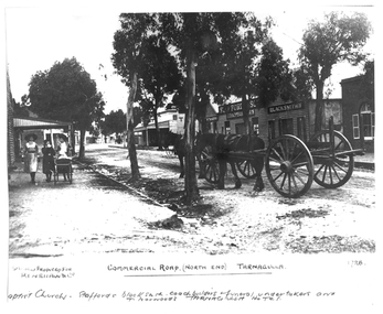 Tarnagulla History Archive
Photograph of the north end of Commercial Road, Tarnagulla, North end of Commercial Road, Tarnagulla, c. 1909
Murray Comrie Collection. This photograph shows business on the north end of Commercial Road, Tarnagulla. From right: the brick Baptist Church (now private residence), Stafford's Blacksmith Coachbuilders and funeral/undertakers (since demolished), & Norwood's Tarnagulla Hotel. Information collated by Murray Comrie: Stafford's premises were built on land previously occupied by the stables of the George Hotel. The Stafford's building was later taken over and run by Frank McNamee. This photograph is a dark copy created from an older original. Copy probably made by Murray Comrie in the 1970s. Monochrome photograph depicting the north end of Commercial Road, Tarnagulla. A large wagon with team of horses is standing in the road. Three girls are walking down footpath at left side of image.Written on the original: 'Specially produced for Renshaw & Co' and 'Commercial Road (North End) Tarnagulla'. Written on this copy: 'Baptist Church Staffords Blacksmith Coachbuilders and funeral/undertakers, & Norwood's Tarnagulla Hotel'.tarnagulla, commerce, industry, blacksmithing, smithing, coachbuilding, businesses, stafford, norwood, mcnamee, buildings, hotels, churches, commercial road, main street -
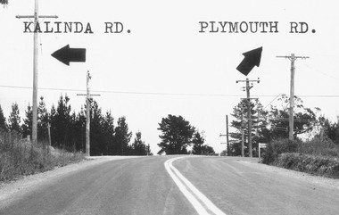 Ringwood and District Historical Society
Photograph, Intersection of Kalinda Road and Plymouth Rd. Ringwood 1967
B&W Photograph with road names and arrows added.Catalogue card reads, "Intersection of Kalinda Road and Plymouth Rd. 1967". -
 Kew Historical Society Inc
Photograph, Stuart Tompkins Studio, Electricity Supply Poles, South Road, Moorabbin, 1965
Research provided by Stuart Tompkins Studio, Box Hill, into alternatives for median strip street lighting to be used in Burke Road, Kew. The photographers identified variants in different suburbs appropriate to Kew's needs.The series from which the photograph is drawn provides a snapshot by a commercial photographic studio of each named vicinity in 1965 as well as providing examples of public works infrastructure being commissioned by local government in the 1960s. The photos originally formed part of the Engineering Department's files in the City of Kew before being donated to the kew Historical Society.Electricity Supply Poles, South Road, Moorabbin, 1965. Stuart Tompkins Studio provided this photograph for the Kew City Council. The photograph of South Road, Moorabbin, west of Jasper Road, looking east depicts steel poles with two lamps in a median strip and supply wires from pole to pole. The poles were described as 100′ apart. The notation on the rear of the photograph was that there were lamps along the median strip except at intersections. A wooden pole is recognised as supporting heavy supply lines across the road. The steel poles in the photograph were said to be between 3′ to 3.5′ whereas the wooden poles were three to 12.25″ in diameter. [There are three copies of this photograph in the Collection.] Typed inscription on reverse: "Electricity Supply Poles. Photographed for Kew City Council 8/2/65. No.2 South Road - Moorabbin, west of Jasper Road, looking east. Steel poles with two lamps in median strip and supply wires from pole to pole along median strip (poles only 100' apart). Lamps along median only except at intersections. Wooden pole supports heavy supply lines across the road. Wooden poles 3' up and 8 1/2" dia. Wooden poles 3' up and 12 1/2 dia." Studio stamp: "Stuart Tompkins Studio. 547 Station Street, Box Hill. WX1439."public infrastructure -- kew (vic.), city of kew - engineers department -
 Kew Historical Society Inc
Photograph, Stuart Tompkins Studio, Electricity Supply Poles, South Road, Moorabbin, 1965
Research provided by Stuart Tompkins Studio, Box Hill, into alternatives for median strip street lighting to be used in Burke Road, Kew. The photographers identified variants in different suburbs appropriate to Kew's needs.The series from which the photograph is drawn provides a snapshot by a commercial photographic studio of each named vicinity in 1965 as well as providing examples of public works infrastructure being commissioned by local government in the 1960s. The photos originally formed part of the Engineering Department's files in the City of Kew before being donated to the kew Historical Society.Electricity Supply Poles, South Road, Moorabbin, 1965. Stuart Tompkins Studio provided this photograph for the Kew City Council. The photograph of South Road, Moorabbin, west of Jasper Road, looking east depicts steel poles with two lamps in a median strip and supply wires from pole to pole. The poles were described as 100′ apart. The notation on the rear of the photograph was that there were lamps along the median strip except at intersections. A wooden pole is recognised as supporting heavy supply lines across the road. The steel poles in the photograph were said to be between 3′ to 3.5′ whereas the wooden poles were three to 12.25″ in diameter. [There are three copies of this photograph in the Collection.] Typed inscription on reverse: "Electricity Supply Poles. Photographed for Kew City Council 8/2/65. No.2 South Road - Moorabbin, west of Jasper Road, looking east. Steel poles with two lamps in median strip and supply wires from pole to pole along median strip (poles only 100' apart). Lamps along median only except at intersections. Wooden pole supports heavy supply lines across the road. Wooden poles 3' up and 8 1/2" dia. Wooden poles 3' up and 12 1/2 dia." Studio stamp: "Stuart Tompkins Studio. 547 Station Street, Box Hill. WX1439."city of kew -- engineers department, public infrastructure -- kew (vic.) -
 Kew Historical Society Inc
Photograph, Stuart Tompkins Studio, Electricity Supply Poles, South Road, Moorabbin, 1965
Research provided by Stuart Tompkins Studio, Box Hill, into alternatives for median strip street lighting to be used in Burke Road, Kew. The photographers identified variants in different suburbs appropriate to Kew's needs.The series from which the photograph is drawn provides a snapshot by a commercial photographic studio of each named vicinity in 1965 as well as providing examples of public works infrastructure being commissioned by local government in the 1960s. The photos originally formed part of the Engineering Department's files in the City of Kew before being donated to the kew Historical Society.Electricity Supply Poles, South Road, Moorabbin, 1965. Stuart Tompkins Studio provided this photograph for the Kew City Council. The photograph of South Road, Moorabbin, west of Jasper Road, looking east depicts steel poles with two lamps in a median strip and supply wires from pole to pole. The poles were described as 100′ apart. The notation on the rear of the photograph was that there were lamps along the median strip except at intersections. A wooden pole is recognised as supporting heavy supply lines across the road. The steel poles in the photograph were said to be between 3′ to 3.5′ whereas the wooden poles were three to 12.25″ in diameter. [There are three copies of this photograph in the Collection.] Typed inscription on reverse: "Electricity Supply Poles. Photographed for Kew City Council 8/2/65. No.2 South Road - Moorabbin, west of Jasper Road, looking east. Steel poles with two lamps in median strip and supply wires from pole to pole along median strip (poles only 100' apart). Lamps along median only except at intersections. Wooden pole supports heavy supply lines across the road. Wooden poles 3' up and 8 1/2" dia. Wooden poles 3' up and 12 1/2 dia." Studio stamp: "Stuart Tompkins Studio. 547 Station Street, Box Hill. WX1439."stuart tompkins studio, street lighting, south road (moorabin) 1965, public infrastructure -- city of kew, city of kew -- engineer's department -
 City of Moorabbin Historical Society (Operating the Box Cottage Museum)
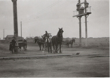
Photograph - Plateway (Wheelway) Steel, circa 1885
... roads ...By the later 1800s the dirt roads in the then out-lying areas of the City of Moorabbin became dangerous, and almost impassable due to huge potholes and muddy swampy areas. The heavily laden market gardener’s carts regularly broke axles and wheels, and horses foundered on their way to the Melbourne markets. Even worse, the heavier “iron maidens”, carrying their malodorous loads of sewage from Melbourne’s inner suburbs for dumping in the outlying areas of the City of Moorabbin, also got bogged in the mire. It was decided that a practical solution to this problem was to install a metal plateway on the side of the problematic roads. In about 1887 the Moorabbin Shire Centre Road, in the Brighton East area, two parallel metal rails were installed so that the wheels of carts could run along smoothly, the horse travelled in the filled, middle area between the rails. Point Nepean Road plateway was removed in 1930 and Centre Dandenong Road plateway was removed in 1934-35. The worn plateway along Centre Road, East Brighton (now known as Bentleigh), was gradually taken up in several pieces, commencing in the the1920s, when its condition deteriorated and it caused a hazard to bikes, pedestrians, motor-cycles and the few early cars. The early steel plateway, constructed by David Munro, and opened on 23rd March 1885 by Thomas Bent, was built along Nepean Highway, between Asling St. and Bay St. The Point Nepean Track was subsequently extended into Moorabbin with branches along Centre, Cumins, South, Wickham, and Keys Roads, the total length was 13 miles. In 1908-1909 plates were laid along Centre Dandenong Road to Ross Street Bentleigh This innovative solution proved successful and was used until gradually the main roads were upgraded, and motorised vehicles started to appear. Two parallel metal rails were installed in the right hand side of a few main roads in the Shire of Moorabbin so that the wheels of heavily-loaded market gardener's carts on their way to markets in Melbourne could run along smoothly. The horse pulling the carts travelled in the filled, middle area between the rails. The Steel Plateway was constructed by David Munro, and opened on 23rd March 1885 by Thomas Bent. The wheelway first only ran along Nepean Highway, but it soon extended from Centre Dandenong Road, along Nepean road to its junction with Chapel Street, St Kilda. Later branch lines were built along Centre Road, Bentleigh as far as Warrigal Road and, according to early photographs, along Wickham Road Moorabbin as well. This innovative solution proved successful and was used until gradually the main roads were upgraded, and motorised vehicles started to appear. There was a problem with the wheelway : there was only a single set of rails and this was established on the right-hand side of the Nepean Road, travelling towards the city. Traffic FROM the city travelled on the correct or left-hand side of the road. The exception to this rule was the malodorous iron-clads, heavily riveted iron carts, generally travelling in convoy, carrying several tons of human effluent out of Melbourne to be trenched-in in the sandy soil of the Moorabbin district. Moorabbin City Council donated and installed a small section of Plateway at Box Cottage Museum in 1984melbourne, brighton, moorabbin, roads, plateway, wheelway, transport, st kilda, bent thomas, munro david, market gardens, steelway, carts horse-drawn, iron maidens, point nepean track -
 Clunes Museum
Photograph, BALLARAT ROAD, CLUNES, SOUTH WEST, 1865
PHOTOGRAPH SHOWS MANSE PREBYTERIAN [ST ANDREWS[ CHURCH METHODIST [WESLEY[ WITHOUT SPIRE, SUNDAY SCHOOL AND PARSONAGE MARKET, POST OFFICE SITE TOWN HALL PHOTOGRAPH OF BALLARAT ROAD [SERVICE STREET] CLUNES. PHOTOGRAPH TAKEN FROM GEORGE STREET TOWARDS SMEATON ROAD. .1 SEPIA PHOTOGRAPH MOUNTED, WITH POINTS OF INTEREST NOTED AROUND EDGE. PERIOD 1865 .2 BLACK AND WHITE PHOTO PRINT .3 SMALL BLACK AND WHITE PHOTO PRINTBALLARAT ROAD, CLUNES, SOUTH WESTphotography, photographs, township, churches -
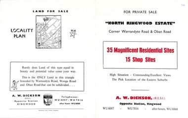 Ringwood and District Historical Society
Flyer, Land Sale Brochure, North Ringwood Estate, Ringwood, Vic. - 1958
Double-sided land sale advertisement for sale of 35 residential and 15 shop sites on the corner of Warrandyte Road and Oban Road, Ringwood North, Vic., including locality plan and features of the estate.Subdivision includes Oban Road, Warrandyte Road, and Dickson Crescent. Agent: A.W. Dickson, Opposite Station, Ringwood. (Phone) WU6007, WU7016, after hours WU6868. -
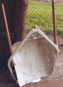 City of Moorabbin Historical Society (Operating the Box Cottage Museum)
Tool - Horse-drawn Metal Scoop Road-working
... roads ...This medium sized metal, horse-drawn, road-working scoop, with timber shafts is an example of those used in Moorabbin Shire in the late 1800s, and up until the 1940s for road-works, building dams, market-gardening work and other similar earthworks in the shire. The Box Cottage museum example would have been drawn by one horse, with the worker walking and steering the horse and scoop from behind using the timber shafts. There were even bigger metal scoops that required two or more horses to drag the scoop through the soil.Following the Dendy Special Survey 1841 allotments were sold to pioneer settlers who established market gardens in the Moorabbin area. Roads and roadside dams were needed as they transported both their stock and garden produce to markets in St Kilda and Melbourne By1880 the Shire of Moorabbin was using horse-drawn, road-working shovels on the main thoroughfares of the district.A medium sized metal, horse-drawn, road-working scoop, with timber shafts. Used by Moorabbin Shire in the late 1800s, and early 1900s for road-works, and other similar work in the shiremelbourne, shovel, brighton, moorabbin, metal, gardens, roads, markets, mckinnon, cheltenham, horse drawn, scoop, dendy henry, st kilda -
 Kew Historical Society Inc
Photograph - Corner of Normanby and Parkhill Roads, Kew, 1926
The section of Normanby Road, Kew from Cotham Road to Parkhill Road was officially gazetted in 1865. The part of Normanby Road between Parkhill Road and Harp Road was gazetted ten years later in 1875. Parkhill (sometimes Park Hill) Road East and Parkhill Road West were both gazetted in 1865.Original, black and white positive print of a photograph taken from a house in Normanby Road across the road to another house on the corner of Normanby and Parkhill Roads. The hills of Kew can be seen in the background. The main house in the photo is 57 Normanby Road.Inscribed verso: "Normanby Rds and Parkhill Rds corner " normanby road -- kew (vic.), parkhill road -- kew (vic.), 57 normanby road -- kew (vic.) -
 Orbost & District Historical Society
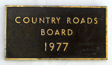
plaque, 1977
The Country Roads Board was the government authority for the construction and maintenance of main roads in Victoria between 1913 and 1983. It was succeeded by the Road Construction authority on 1 July 1983 and later merged with the Road Traffic Authority on July 1 1989 to form the Roads Corporation. James Cameron, an Orbost farming pioneer and Member of the Legislative Assembly, fathered the Country Roads Board. This plaque was possibly removed from a bridge(?) when the name was changed.A heavy rectangular shaped bronze plaque. the background is dark brown and the print and frame bronze coloured. On the back are two round recesses for screwing and attaching the plaque.COUNTRY ROADS BOARD 1977country-roads-board cameron-james -
Whitehorse Historical Society Inc.
Article, Springvale Road tops accident list, 2004
An interview with Ken Ogden of the RACV identifies Springvale Road as the road most likely to have car accidents in Melbourne.An interview with Ken Ogden of the RACV identifies Springvale Road as the road most likely to have car accidents in Melbourne. Included in the worst five corners are those with Whitehorse Road and Canterbury Road.An interview with Ken Ogden of the RACV identifies Springvale Road as the road most likely to have car accidents in Melbourne. road accidents, royal automobile club of victoria, whitehorse road, nunawading, springvale road, nunawading, springvale road, forest hill, canterbury road, forest hill -
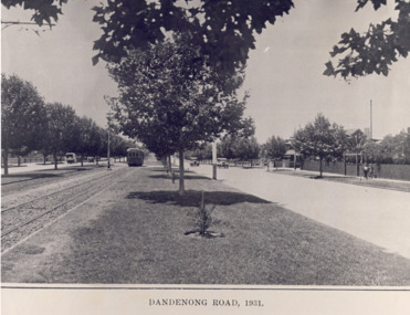 St Kilda Historical Society
Photograph - Photograph of Dandenong Rd, Dandenong Road 1931, 1931
A black and white photograph of an earlier print, showing the central park in the middle of Dandenong Road, including trees and the tram tracks along with a tram several cars and some pedestrians walking by.Dandenong Road, 1931 -
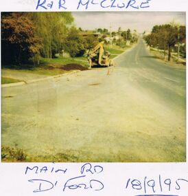 Bendigo Historical Society Inc.
Photograph - CASTLEMAINE GAS COMPANY COLLECTION: PHOTO DAYLESFORD, 18/09/1995
... Roads ...R&R McClure - Main road Daylesford 18/09/1995Polaroidplace, roads, daylesford -
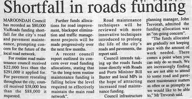 Ringwood and District Historical Society
Newspaper, Scrapbook Clipping, Library Collection, Ringwood, Victoria
Newspaper clipping from "The Post", 16-8-95, P5 - Shortfall in roads fundingMaroondah Council has recorded an $80,000 Vicroads funding shortfall for the city's road and pavement maintenance, prompting concern for the future of the local road network. -
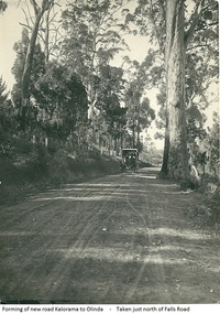 Mt Dandenong & District Historical Society Inc.
Photograph, Forming Of New Road Kalorama To Olinda, early 1920s
The new Main Road, now Mt Dandenong Tourist Road, was completed in 1926. This scene is looking towards Montrose down from the intesection of Falls Road.Scene of wagon drawn by two horses on wide dirt road with large trees on side of road. Taken just north of Falls Road.wagon, road, main road, mt dandenong tourist road, falls road, horse