Showing 844 items
matching surveyors
-
 Eltham District Historical Society Inc
Document - Folder, Murphy, James and descendants
James Murphy was a mining surveyor involved with the Caledonia diggings. Contents Note from Ray Blake, 26 April 2000: Ms Murphy said her people had traditionally owned all of inner Melbourne, north to the Great Divide, West to Werribee River, East to Mt Baw Baw, South to Mordialloc Creek.Newspaper clippings, A4 photocopies, etcjames murphy -
 Orbost & District Historical Society
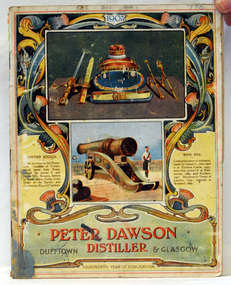
magazines, Banks & Company, Peter Dawson Distiller, 1907
This is the 14th edition of the magazine. This magazine belonged to William Hunter (1893-1971), a resident of Tatura and Mallacoota. He was a soldier, surveyor and amateur naturalist. Peter Dawson was a Distiller and Whisky Merchantat 99 Maxwell Street, Glasgow. By 1891 Dawson had already made a name for himself in the United Kingdom as a blender of whisky and practical distiller. This item is associated with William Hunter.A magazine / catalogue with a cover showing coloured illustrations of military weapons and ordinance. At the bottom is "Peter Dawson Distiller Dufftown & Glasgow" in red and black print inside an ornate gold frame."William Hunter"hunter-william dawson-peter-distiller magazine-weapons-ordinance -
 Orbost & District Historical Society
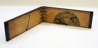
clinometer rule, mid 19th -earl 20th century
This clinometer, is a hand-held optical scientific instrument used in surveying to measure vertical angles. It is used to measure the angle of elevation from the ground in a right-angled triangle. It may have been used by a surveyor or a forester to measure the height of tall things where you couldn't possibly reach to the top of e.g. flag poles, buildings or trees.This item is an example of an early hand held measuring instrument.. Today the use of electronic sensors is an important component in the design and function of the clinometers.A rectangular wooden folding measuring instrument. the panels are brass framed. Inside is a brass semi-protractorgraduated 90-0-90' with index arm pointeran dwith a graduated edge in inches. Outside is a temperature conversion scale,Troughton & Simms, LONDONscientific-instrument measurement clinometer -
 Federation University Historical Collection
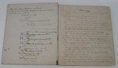
Book - Exercise Book, Astronomy Notes by William Baragwanath, 1897
William Baragwanath studied at the Ballarat School of Mines, obtained a Geology certificate in 1911. He was born on 01 August 1878 at Ballarat. He joined the Victorian Department of Mines in 1897 and was Chief Mining Surveyor from 1924 to 1943. Baragwanath died at Prahran on 20 September 1966. See Book 2 - Catalogue Number 4530Marbled card covered exercise book with brown tape spine containing handwritten notes by William Baragwanath on Astronomy and astronomical, geodetic, geights and distances, North Line Latitue, Lime, etc., problems . Headings include: Astronomy refraction Correction for Semi diameter Determination of True Meridian Elongation Observation Latitude Determining the TIme Convergence of Meridian Barometric Measurement of Heights Formulae Latitude Observation On the Division of Land Calculations for Observations by a Single Altitude Computations Triginometrical Rations of Two Arcsballarat school of mines, astronomy, william baragwanath -
 Federation University Historical Collection
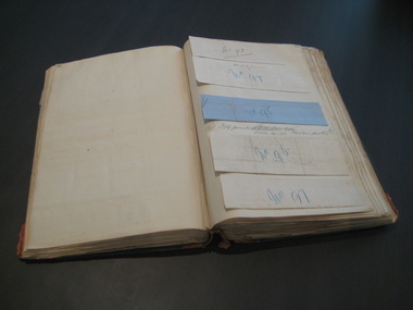
Book, Ballarat School of Mines Invoice Book, 1870 - 1875
Scrap book containing invoices relating to accounts to be paid by the Ballarat School of Mines between 1870 until 1875. The School of Mines at Ballarat was the first school of Mines in Australia and was established in 1870. The works done to the former Ballarat Circuit Court House were overseen by Robert Davidson (architect and Surveyor) with the contractor being James Williams. Large book, green leather with red binding, numerous original invoices pasted onto the pages. The first pages of the scrapbook includes correspondence relating to the refurbishment of the former Ballarat Court House which was used as the Ballarat School of Mines from 1870. The building was demolished c1913 to make way for the Ballarat Technical Art School (still standing). * 23 August 1870 - Bateman, Clark & Co, The Ballarat Courier * August 1870 - Klug Bros. Furniture and Bedding Warehouse * April 1870 - J. Armstrong * Statement of Receipts and Expenditure from 23rd Aug. 1870 to 19 January 1871 * W. Gooch, * 1870 - William L. Mullen, Ballarat Stationery Warehouse & Printing Office, * 31Jany. 1871 - A.H. King, Iron Merchant, * 1 February 1871 - Richard Tunbridge, Timber Merchant, * January 4th 1871- Henry Gough, * 8th March 1871 William Murfet, * March 1871- Maxwell Morrow, * 1 February 1871- James Curtis, Caxton Steam Printing Works, * May 4th 1871 - William Blomeley, Iron and Brass Founder, * 4 May 1871 - Thomas Rogers, Draper, Milliner, Haberdasher & c. * May14 1871- George Shannon & Co, Importers of China, Glass & Earthenware, * May 31st 1871, Wreford & Co, Machine Printers, *1st July 1871 William McCulloch & Co,( late Reynolds and English) General Carriers to all parts of the Colony, * 1871- J.J. McDonald, Plumber and Gas Fitters, * August 29th 1871 - Eyres Brothers, Furnishing and General Ironmongers, * 1st August 1871, Frank Pinkerton,H Ben. Franklin Printing and Stationary House 18, Armstrong Street, Ballarat. * 12TH July 1871 J. Donovan, * 10th August, 1871 - Edward Rand, Wholesale Druggist & Importer, *11 Nov 1871 - Matthew Hamilton, * October 2nd 1871 - C.B. Retallack, Engineer and General Smith, *December 8 1871 - James Harrington, * June 1871 - Wayne, Wholesale Druggist * 21st Nov. 1871 - Smith Brothers, Timber Merchants. * 5 January 1872 - T. Eggington, Carpenter, * 12 January 1872 - James Fayle, Plumbers & Ironwork * January 26th 1872 - S. Stansfield, * August 10th 1872 - John H. Hammond Wholesale and Retail, Bookseller, Commercial and General Stationer, etc. etc."VOUCHER" inscribed on spine in gold Each invoice pasted into the scrapbook has a number written onto it. The numbers are in chronological order at start at 1 in each calendar year. ballarat school of mines, redmond barry, hugh gray, henry richards caselli, henry caselli, joseph flude, ballarat court house, harrie wood, clock, invoice book, robert davison, james williams, ballarat circuit court house, old ballarat court, emanuel steinfeld, j.t. sleep, c.b. retallack, john phillips, eyres bros, ballaarat gas company, national insurance company, broadbent bros, charles evans, niven and co, william johnson, william ford, george robertson, william vale, m.d. hamilton, plumbago crucible company, morgans crucibles, h.r. caselli, henry richards caselli, george evans, bateman, clark & co,, klug bros., j. armstrong, w. gooch,, william l. mullen, a.h. king, richard tunbridge, henry gough,, william murfet,, james curtis, william blomeley,, thomas rogers, george shannon, wreford, william mcculloch, j.j. mcdonald, frank pinkerton, ben franklin printing and stationary house, j. donovan, edward rand, matthew hamilton, c.b. retallack,, james harrington, smith brothers,, james fayle,, maxwell morrow,, s. stansfield, walhalla, brunswick house, t rogers -
Federation University Historical Collection
Book - Exercise Book, William Baragwanath, Astronomy Notes Volume 2, 21/06/1897
William Baragwanath studied at the Ballarat School of Mines, obtained a Geology certificate in 1911. He was born on 01 August 1878 at Ballarat. He joined the Victorian Department of Mines in 1897 and was Chief Mining Surveyor from 1924 to 1943. Baragwanath died at Prahran on 20 Septemeber 1966. See Book 2 - Catalogue Number 4530Marbled card covered exercise book with black tape spine containing handwritten notes by William Baragwanath on astronomical problems . Headings include: Observed Altitude of Moons Algebra trigonometry Spherical Trigonometry Definitions in Astronomyballarat school of mines, astronomy, william baragwanath -
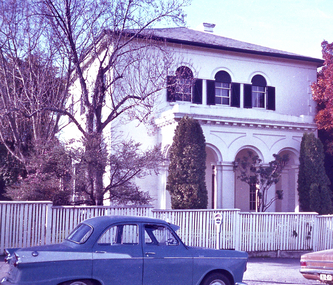 Bendigo Historical Society Inc.
Negative - DUDLEY HOUSE COLLECTION: NEGATIVES OF DUDLEY HOUSE PLUS 3 IMAGES
Dudley House brick building is one of the earliest and most intact 1850s buildings remaining in Bendigo CBD. Like all government buildings of this era, its exterior is fairly modest, unlike the opulent styles of later decades. It was originally built as a residence for the district surveyor, who designed the Bendigo street layout that we still use to this day. Strip of Photo Negatives of Dudley House in View Street Bendigo, Victoria Australia. 3 Images date unknown, but car parked out of front of property is from the 1960s. Looks like a wooden fence is enclosing the property can we date image from this?bendigo, buildings, dudley house -
 Kew Historical Society Inc
Plan - Subdivision Plan, High Street, Kew, 1920-1935
Pru Sanderson, in her groundbreaking ‘City of Kew Urban Conservation Study : Volume 2 - Development History’ (1988), summarised the periods of urban development and subdivisions of land in Kew. The periods that she identified included 1845-1880, 1880-1893, 1893-1921, 1921-1933, 1933-1943, and Post-War Development. These periods were selected as they represented periods of rapid growth or decline in urban development. An obvious starting point for Sanderson’s groupings involved population growth and the associated economic cycles. These cycles also highlighted urban expansion onto land that was predominantly rural, although in other cases it represented the decline and breakup of large estates. A number of the plans in the Kew Historical Society’s collection can also be found in other collections, such as those of the State Library of Victoria and the Boroondara Library Service. A number are however unique to the collection.The Kew Historical Society collection includes almost 100 subdivision plans pertaining to suburbs of the City of Melbourne. Most of these are of Kew, Kew East or Studley Park, although a smaller number are plans of Camberwell, Deepdene, Balwyn and Hawthorn. It is believed that the majority of the plans were gifted to the Society by persons connected with the real estate firm - J. R. Mathers and McMillan, 136 Cotham Road, Kew. The Plans in the collection are rarely in pristine form, being working plans on which the agent would write notes and record lots sold and the prices of these. The subdivision plans are historically significant examples of the growth of urban Melbourne from the beginning of the 20th Century up until the 1980s. A number of the plans are double-sided and often include a photograph on the reverse. A number of the latter are by noted photographers such as J.E. Barnes.A roughly drawn and faded actual or projected subdivision of a parcel of land bordering on High and Mary Streets. The plan shows five allotments facing High Street and at their rear, another allotment facing Mary Street. In 1906, when the Board of Works surveyors completed Detail Plan 1589, the allotment in Mary Street is shown to include a building. The section of land attached to this building is shown to be undeveloped, thus making a further subdivision possible.subdivision plans - kew, high street -- kew (vic.), mary street -- kew (vic.) -
 Melbourne Tram Museum
Drawing, "Plan of Survey of Part of Crown Allotments 15 and 16 at Hawthorn, Parish of Boroondara, County of Bourke", 1922
Drawing, coloured with water based drawing wash, titled "Plan of Survey of Part of Crown Allotments 15 and 16 at Hawthorn, Parish of Boroondara, County of Bourke". Shows the tram track, Wallen Road, changes around the intersection with Power St, buildings. A note at the bottom notes who owns what - MMTB and City of Hawthorn. Prepared by H. S. McComb, licensed Surveyor 6-9-1922. Stored folded.Stamped "Drawing Office" "Office Copy" and in red pencil "Hawthorn" in the bottom right hand corner, and on the rear "Drawing Office" "Office Copy" and "Hawthorn Depot" in pencil.trams, tramways, htt, mmtb, hawthorn depot, plans -
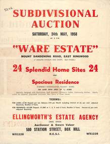 Ringwood and District Historical Society
Flyer, Subdivisional Auction Sale Brochure, Ware Estate, East Ringwood, Vic. - 1958
Folded double-sided advertisement for auction of 24 home sites and existing residence on Saturday, 24th May, 1958, including locality map, subdivision layout, terms of sale, and summary of local facilities and services. Additional plan of lots 28-33 dated 26/10/60 by Licensed Surveyor for Kirkpatrick & Webber, 225 Maroondah Highway Ringwood headed Plan of Subdivision of part of Crown Allotment 26A Parish of Ringwood.Subdivision includes Mount Dandenong Road, Ware Crescent, Davey Drive, and Grey Road (later Grey Street). Timber residence included in the subdivision was formerly Ware Kindergarten Holiday Home. (Agent) Ellingworth's Estate Agency, 580 Station Street, Box Hill - (Phone) WX1228. -
 Warrnambool and District Historical Society Inc.
Letter book 8, Letters on Hyd Engineering
This book contains letters and mathematical computations on hydraulic engineering. The material has been compiled by Arnold Lilley (Lilly), an Oxford mathematician working in Victoria in the 1890s. It is said that he taught or coached 95% of the municipal surveyors in Victoria in the 1890s. The book came from the office of one of Lilley’s pupils, John William Crawley Junior, an engineer, surveyor and architect with a private practice in Warrnambool and also the engineer for the Shire of Warrnambool from 1895 to 1935. It is presumed that he had the letters bound in book form. The book passed to his son, Rolf Crawley, the engineer for the Shire of Warrnambool from 1935 to 1968. It later came into the possession of Michael Hand who took over the private surveying business of Rolf Crawley in Warrnambool. The Warrnambool and District Historical Society acquired the book, along with other Crawley ledgers, from the estate of Michael Hand.This book is of interest as a memento of the 1890s teachings of the mathematician, Arnold Lilley and also of his pupil, John William Crawley, the engineer for the Shire of Warrnambool for 40 years.This is a blue hard-cover book containing handwritten letters and computations. There are some loose pages and some pages have postal stamps on them. The book spine is slightly scuffed. ‘Letters on Hydraulic Engineering by Arnold Lilly Esq Mathematical Coach. J. Wm. Crawley Junior Pupil’rolf crawley, warrnambool, john william crawley junior, warrnambool, shire of warrnambool, arnold lilley, mathematician and teacher -
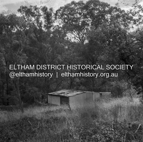 Eltham District Historical Society Inc
Negative - Photograph, J.A. McDonald, Road Reserve Housing, Mar. 1961
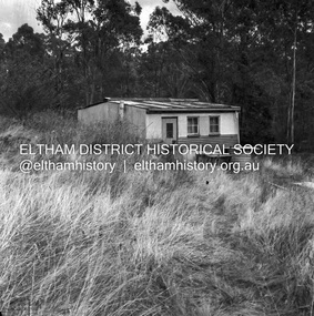
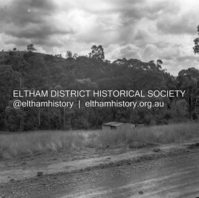
Shack built on road reserve without permit Most probably up on Simms Road, Kinglake Other areas where illegal shacks were built wer at the junction of Flat Rock Road and Cherry Tree Road, Hurstbridge. At times, Building Surveyor George E Newton would have to attend to these shacks for inspection and issue demolition ordersRecord of various Shire of Eltham infrastructure works undertaken during the period of 1952-1962 involving bridge and road reconstruction projects, sometimes with Eltham Shire Council Project Reference numbers quoted. It was during this period that a number of significant improvements were made to roads and new bridges constructed within the shire that remain in place as of present day (2022). In many situations, the photos provide a tangible visible record of infrastructure that existed throughout the early days of the Shire. The album was put together by or under the direction of the Shire Engineer, J.A. McDonald.infrastructure, shire of eltham, 1961-03, building surveyor, cherry tree road, flat rock road, george e. newton, houses, hurstbridge, kinglake, road reserve, road reserve housing, scan - 120 format 6x6 negative, shack, simms road -
 Eltham District Historical Society Inc
Negative - Photograph, J.A. McDonald, Road Reserve Housing, Mar. 1961
Shack built on road reserve without permit Most probably up on Simms Road, Kinglake Other areas where illegal shacks were built were at the junction of Flat Rock Road and Cherry Tree Road, Hurstbridge. At times, Building Surveyor George E Newton would have to attend to these shacks for inspection and issue demolition ordersRecord of various Shire of Eltham infrastructure works undertaken during the period of 1952-1962 involving bridge and road reconstruction projects, sometimes with Eltham Shire Council Project Reference numbers quoted. It was during this period that a number of significant improvements were made to roads and new bridges constructed within the shire that remain in place as of present day (2022). In many situations, the photos provide a tangible visible record of infrastructure that existed throughout the early days of the Shire. The album was put together by or under the direction of the Shire Engineer, J.A. McDonald.infrastructure, shire of eltham, 1961-03, building surveyor, cherry tree road, flat rock road, george e. newton, houses, hurstbridge, kinglake, road reserve, road reserve housing, scan - 120 format 6x6 negative, shack, simms road -
 Greensborough Historical Society
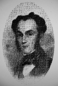
Photograph - Digital image, Portrait of Edward Green, 1850c
Portrait of Edward Green. In the 1840s, Edward B. Green ran the mail service between Melbourne and Sydney and owned a parcel of land on the Plenty River. He engaged a surveyor to draw up plans and lay out a township on the slopes overlooking the river, and to mark out small farm holdings on the flats. This small township named after him is now Greensborough.Digital copy of portrait.edward bernard green, greensborough history -
 Ringwood and District Historical Society
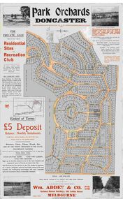
Map, Park Orchards Land Sale Advertisement, Doncaster, Victoria, Circa 1926
Large linen backed map of the Park Orchards subdivision for private sale of residential sites and recreation club, highlighting local facilities, services and layout of the estate. Surveyors - Tuxen & Miller, 34 Queen Street, Melbourne. Agents - Wm Addey & Co., Pty Ltd., National Mutual Buildings, 395 Collins Street, Melbourne, Phone F3906. Terms £5 deposit balance monthly installments of £1 with the residue at the end of five years. Subdivision includes Alva Avenue, Arundel Road, Aviemore Avenue, Berringa Road, Bowmore Avenue, Brucedale Crescent, Brympton Avenue, Camber Avenue, Cawdor Avenue, Colin Avenue, Corriedale Crescent, Craithie Avenue, Daintree Avenue, Dalry Avenue, Dirlton Crescent, Drayton Crescent, Elgin Crescent, Enfield Avenue, Ennismore Crescent, Euston Avenue, Feversham Avenue, Frogmore Crescent, Gosford Crescent, Granard Avenue, Hopetoun Road, Hylton Avenue (later Knees Road), Jura Avenue, Park Road. -
 Bendigo Historical Society Inc.
Document - HANRO COLLECTION: PLANS AND REPORT FROM FIRE ENGINEERS AND SURVEYORS, 1954/1960
Plans and Report from Fire Engineers and Surveyors:- Green Card has a rectangular box with an ornate border in the centre of the front page. Inside the border is typed in black *Plans, Hanro (Aust) Knitting Mills Limited, Bendigo Victoria Australia. At the bottom:- Mahlstedt's (Vic) Pty Ltd. (est. 1884). Consulting Fire Engineers and Surveyors. Temple Court, 422 Collins Street., Melbourne C.1. Telephone 673069. Inside the folder is the Key to Detail Block Plans & Fire Surveys. Correspondence from Mahlstedt's Pty Ltd to Edward Lumley and Sons, Insurance Brokers regarding a new survey and the changes to the building with respect to fire hazard. Main report recommendations and general information on the building. Blue print of Shirt Factory, Inglewood Road No. 1061 by Welmar Ltd Bendigo. Small blue print of the main buildings showing different work areas. Blue print No.1119 of John Brown Industries Ltd Alley Street Bendigo showing work areas. Box 116AMahlstedt's (Vic) Pty Ltdhanro, clothing, plans and reports, edward lumley & sons pty ltd. hanro knitting mills. mahlstedt's (vic) pty ltd. welmar ltd bendigo. john brown industries ltd. -
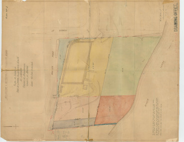
University of Melbourne, Burnley Campus Archives
Plan, [Historical Maps of Richmond Park], 1862-2000
(1) Proposed reserve for Horticultural & Experimental Garden in the Survey paddock Richmond. R.19A (1865). Shows Swan Street Extension. Gazettals 1877, 1887. (2) As (1). Half of map only Annotation by A. Purchas, 9 October, 1862. (3) Plan of Richmond park. A.L. Martin Authorised Surveyor, 31st August, 1872. [Dept. of lands & Survey Melbourne, J. Noone, 6th September 1872.] Map in 4 sheets. (4) Richmond Park. Surveyed by Geo. Black, Authorised Surveyor 13.8.91 (2 copies). (5) [Richmond Park] Shows road alignments gazetted 1871 & 1881 (part copy only - Neg. 18375). (6) City of Richmond Parish of Jika Jika County of Bourke. Department of lands & Survey, 1919 (annotations i.e. Melb. City Link, Amrad, etc. to 1994.) (7) Burnley gardens, 2000. Produced by P. Tulk, Institute of Land & Food Resources, Burnley College, 2000 (re area proposed for heritage listing.)richmond park, survey paddock -
 Greensborough Historical Society
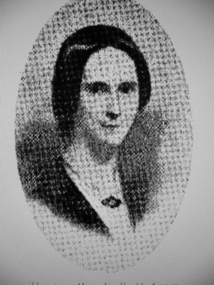
Photograph - Digital image, Mrs Edward Green, 1850c
Portrait of Mrs Edward Green. In the 1840s, Edward B. Green ran the mail service between Melbourne and Sydney and owned a parcel of land on the Plenty River. He engaged a surveyor to draw up plans and lay out a township on the slopes overlooking the river, and to mark out small farm holdings on the flats. This small township named after him is now Greensborough.Digital copy of portraitedward bernard green -
Tatura Irrigation & Wartime Camps Museum
Gunter's Chain
This is a surveyor's chain or Gunter's chain, an instrument used for measuring length. It comprises 100 pieces of straight metal wire, looped together end to end, and fitted with swivel handles. Its overall length is one chain (22 yards or 66 feet). The Gunter's chain was named after its inventor, Edmund Gunter (1581-1626), an English clergyman, mathematician, and astronomer. survey -
 Bendigo Historical Society Inc.
Document - The naming of Dudley House Bendigo, 2/11/2023
Dudley House at 60 View St, Bendigo was built by builders, Gretchen and Cooper for the public Works Department in 1858-59. It was originally built for the district surveyor, Richard Larritt, who designed the Bendigo street layout. One of its earliest claims to fame was the hosting of world famous singer, Jenny Lind, in 1861, when she sang to raise money for charity.A nine page document theorizing the history behind the name of the Dudley House building. Written and presented by Terry Davidson.dudley house, view street, bruhn, serah bruhn -
 Ringwood and District Historical Society
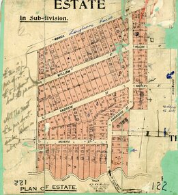
Map, Subdivision Plan, Loughnans Road, Ringwood - circa 1922
Green card with cut-out map of residential allotments, some marked "sold". "Plan of Estate" includes Wonga Road, Loughnans Road, William Street, Andrew Street, Harrison Street, and Munro Street, Ringwood. (Surrounding area is part of Ringwood Park Estate featured in seperate 1922 auction flyer).Handwritten notations - (northern section) {£2-10/- per foot. £5 deposit bal £1 per month} All the rest £2 per foot, value same as above. Licensed Surveyors - W.J. & A.W. Kenhardt, 352 Collins Street, Melbourne. -
 Warrnambool and District Historical Society Inc.
Ledger, Letters on Suspension Bridges, 1890s
This book contains information on the building of suspension bridges and dates from the 1890s. It belonged to John William Crawley Junior, an engineer, surveyor and architect in private practice in Warrnambool and also the engineer for the Shire of Warrnambool from 1895 to 1935. The information in the book comes in the form of lectures on suspension bridge making and these were sent to John Crawley by his tutor or coach, Arnold Lilley (Lilly). Arnold Lilley was an Oxford mathematician working in Victoria and it is said that he coached or trained 95% of the municipal surveyors in Victoria in the 1890s. John Crawley has obviously had this material bound into a book and it was passed on to his son, Rolf, who was the engineer for the Shire of Warrnambool from 1935 to 1968. It then came into the possession of Michael Hand who took over the private surveying business of Rolf Crawley in Warrnambool. The Warrnambool and District Historical Society acquired the book, along with several Crawley ledgers and letter books, from the estate of Michael Hand. This book is of interest as it contains lectures and other material on the building of suspension bridges and belonged to John William Crawley Junior, an engineer for the Shire of Warrnambool for 40 years. It also is a memento of the work of Arnold Lilley who produced the material on suspension bridges and coached John Crawley in his surveying studies.This is a hard cover book with a purple cover. The cover is slightly faded. The book contains handwritten material regarding the building of suspension bridges and includes sketches, lectures on suspension bridges and pages with postage stamps on them. There are three loose pages. ‘’Letters on Suspension Bridges Arnold Lilly Esq. Coach J Wm. Crawley Pupil’john william crawley junior, warrnambool, rolf crawley, warrnambool, shire of warrnambool, arnold lilley, teacher of surveying. -
 Warrnambool and District Historical Society Inc.
Map, Department of Lands and Survey (Lithographers), Caramut township, 1938
This map of the township of Caramut was produced in 1938 but shows the original land owners of each town allotment and of the surrounding area. The size of all the allotments and the date of the original purchase are also shown. Caramut is a Victorian Western District town on Mustons Creek on the Hamilton Highway 48 kilometres from Warrnambool. This map was used by Rolf Crawley when he was the engineer for the Shire of Warrnambool from 1935 to 1968. The annotations on the map have probably been made by Rolf Crawley as they refer to the records and letter books of his father, John William Crawley, Junior (Shire of Warrnambool Engineer 1895 to 1935). Both Rolf Crawley and his father, John had private businesses as architects, surveyors and engineers and the map could have been used in connection with both their official Shire duties and their private businesses. The last owner of the map was the surveyor, Michael Hand who took over the business of Rolf Crawley in the late 1960s. This map is of great interest firstly because it has all the historical details of the land first purchased in the town of Caramut and area and secondly because it came from the office of Rolf Crawley, the engineer for the Shire of Warrnambool from 1935 to 1968. This is a buff-coloured paper map with a cloth backing. The map details are in black and white print. There are some handwritten red and black annotations on the map. “Town of Caramut Parish of Caramut County of Villiers’town of caramut, john william crawley junior, warrnambool, rolf crawley, warrnambool -
 Bendigo Historical Society Inc.
Administrative record - Order for surveys and reports 1926-1940
Green cover book with brown leather spine. Orders for surveys or reports, under the following headings: nature of instructions, correspondence number, when returned. amount of survey fee, by whom paid, date of account passed, remarks. The following surveyors are used: William Archdall, Castlemaine - Garnet G. Birch, Bendigo - J.H. Brown, St. Arnaud - A.A. Briggs. Echuca - A.D. Thomson, Mildura - Tom Lowndes, Kerang - R.A. Black, Nyah West.survey, land, government -
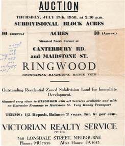 Ringwood and District Historical Society
Flyer - Land Auction Sale, Ten Acres, Maidstone Street Ringwood - 1958
Double sided page advertising Auction, Thursday, July 17th, 1958, (Approx.) 10 Acres, north corner of Canterbury Road and Maidstone Street, Ringwood. Agents - Victorian Realty Service Pty.Ltd., 360 Lonsdale Street, Melbourne, Phone MU7858, After Hours JA1045. Reverse side shows map of proposed subdivision by K.J. Noonan & Co., Surveyors & Engineers, 495 St.Kilda Rd, Melbourne, marked subject to approval of all interested statutory authorities.Residential zoned subdivision land for immediate development. Extensive frontage to Maidstone Street. Accompanying handwritten annotation "10 acres offered as a whole, later re-subdivided". -
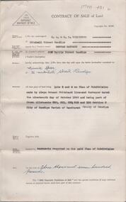 Bendigo Historical Society Inc.
Document - H. A. & S. R. WILKINSON COLLECTION: CONTRACT OF SALE
BHS CollectionContract of sale of land dated 29th November, 1950 between Miss H. Barrass (vendor) and Mrs. M. Speer (purchaser). Property: lots 3 and 4 on plan of subdivision made by Alwyn Ernest Pritchard Licensed Surveyor dated the 19th of October, 1950 and being part of Crown allotment 230, 231, 232, 233 and 125 section H, Parish of Sandhurst City of Bendigo. Price: 3,700 pounds. Attached 8 hand written notes.organization, business, h.a. & s.r wilkinson real estate -
 Melbourne Tram Museum
Document - Research Notes, H. S. McComb, MTT & MTOCo authorised lines, c1956
Notes, 13 pages foolscap sheets pinned in the top left hand corner, 2 loose foolscap pages, 6 quarto pages, providing a sketch map of the MTOCo lines as authorised, length of each line, description, extract from surveyors level books for dates, list of cable car depots and financial notes. Items 2064 to 2075 within box 72.3 in a brown folder marked "MT&O Co." red pencil on the front cover.trams, tramways, mto co, cable trams, drawings, reports, surveys -
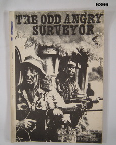 Bendigo Military Museum
Administrative record - Army Survey Regiment Regimental Training 1984 - The Odd Angry Surveyor, Army Survey Regiment, Bendigo, 21 Feb 1984
This is an Administrative Instruction setting out all aspects of the Army Survey Regiment Regimental Training Exercise "Odd Angry Surveyor" during the period 30 Apr - 12 May 1984. The Exercise conducted in two phases, Phase One- being theory lessons in a number of aspects of Infantry Minor Tactics at Section Level, whilst Phase Two- was putting into practice the lessons from Phase One.Light carboard covered A4 paper report stapled on left hand sideroyal australian survey corps, rasvy, fortuna, army survey regiment, army svy regt, asr -
Eltham District Historical Society Inc
Document - Folder, Sadler, William
William Sadler of Eltham contracted to supply forage for Victorian government employees in 1878 Contents Photocopy of page from Victorian Government Gazette, (possibly 1869 or 1 February 1878). List Contracts for Supply of Forage. Handwritten notes on reverse mention dates 1869 and 1 February 1878, and "Forage for government employees, eg surveyors, was a bit issue; it was part of their salary allowances. A big industry."Newspaper clippings, A4 photocopies, etcwilliam sadler, supply of forage for government employees