Showing 433 items matching " transport map"
-
 Melbourne Tram Museum
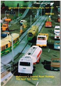
Document - Report, Ministry of Transport, Metropolitan Arterial Road Access Study, Apr. 1987
Report - 88 pages - perfect bound +card covers + fold out map, looks at the development of arterial roads in the various Melbourne regions, includes recommendations and road, management. Has table of contents, diagrams and maps. Includes findings of the studies, issues with freight transport, improvement proposals. Little work on public transport as such. Title "Metropolitan Arterial Road Access Study, April 1987 - Melbourne's Arterial Road Strategy the next 10 years - METRAS" - Has foreword signed off by Tom Roper, Minister for Transport. Report M6trams, tramways, public transport, road transport, minister for transport -
 Melbourne Tram Museum
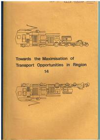
Document - Report, Bernard McNamara, "Towards the Maximisation of Transport Opportunities in Region 14", Jul. 1978
Report - 152 pages + light card brown covers, bound with plastic pin binding, "Towards the Maximisation of Transport Opportunities in Region 14", dated July 1978, Author Bernard McNamara, looking at transport in the Shire of Eltham, Cities of Heidelberg and Northcote. Looks at factors affecting public transport, existing services, problems, possible solutions, initiatives and recommended actions. Includes a table of contents, maps, appendices.On top front cover "Copy for AETA Victorian Division"trams, tramways, public transport, northcote, minister for transport -
 Melbourne Tram Museum
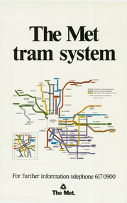
Poster, The Met, "The Met Tram System", mid 1990's
Poster - full colour on semi gloss paper titled "The Met Tram System" showing in a diagrammatic form the Melbourne tram routes, major street names, route numbers, principal suburbs, terminal names, central area (pre Docklands, post light rail to St Kilda and Port Melbourne) and ticket zones. Has The Met logo and the Public Transport Corporation names on the bottom. Mid 1990's, Batman Ave still shown. 2nd copy added 2-2-2019 and scanned, replaced image file.trams, tramways, melbourne, tramways, tram routes, map, posters -
 Melbourne Tram Museum
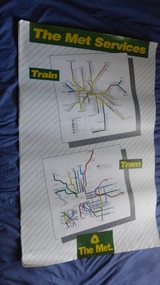
Poster, The Met, "The Met Services", mid 1990's
Poster - full colour on semi gloss paper titled "The Met Services" showing in a diagrammatic form the Melbourne tram and rail routes. For the tram section, (similar to Reg Item 509), shows major street names, route numbers, principal suburbs, terminal names, central area (pre Docklands, post light rail to St Kilda and Port Melbourne) and ticket zones. The rail map section shows the Neighbourhood ticket zones, the rail line via Altona (the direct route is not shown) and shows the St Kilda and Port Melbourne light rail lines. Has The Met logo and the Public Transport Corporation names on the bottom. Mid 1990's, Batman Ave still shown. See also Reg Items 696 and 696 for maps of the time.trams, tramways, melbourne, tramways, tram routes, railways, map, posters, tickets, neighbourhood tickets -
 Melbourne Tram Museum
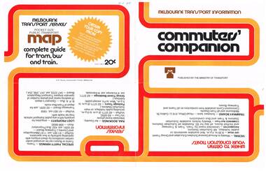
Pamphlet, Minister of Transport, "Commuters' Companion", Mid to late 1970's
Pamphlet, folded sheet, four folds, full colour on white gloss paper titled "Commuters' Companion", published by the Ministry of Transport, providing transport information, contact numbers for bookings, special party hiring's, lost property, VicRail, Tramways Board, Transport Information line. On inside has photos of Silver train, Z 1, main city rail stations, map of central Melbourne, the Transport information centre work room (not a PC to be seen - early cubicles), a Yellow cab taxi at TRB Port Melbourne and a School bus. Telephone numbers a mix of 6 and 7 digit numbers. Mid to late 1970's.In ink in top left hand corner "4J40" - AETA Library location.trams, tramways, minister for transport, melbourne -
 Melbourne Tram Museum
Pamphlet, Public Transport Corporation (PTC), "Free City Circle Tram", mid 1990's
Pamphlet - eight fold to DL size, full colour, titled "Free City Circle Tram" with a photo of a City Circle tram passing Flinders St station. Has information about Melbourne trams, the Melbourne Town Hall, Visitor Information, Walking Trails, a map of the route, with places of interest shown. Map shows the service via Spencer St. Has photos of 2013 and 909 as well. Has the City of Melbourne, Department of Infrastructure and Public Transport Corporation logos. Possible produced during the mid 1990's given the various logos used. .1 - As above, but with Yarra Trams and State Government logos See Reg Items 1387 and 2703 for other versions.trams, tramways, city circle, melbourne, public transport corporation, ptc -
 Melbourne Tram Museum
Map, Melbourne & Metropolitan Tramways Board (MMTB), MMTB Route Maps, 1979
Series of colour maps for various tram and bus routes, dated 1979. Also contained, not scanned are letters, reports, and specifications for printing these maps for use in shelters etc. Some have the Transport Information Centre telephone printed on them. Some are finished with a plastic laminate finish on either one or both sides. Show the major cross streets, parks, schools, other tram routes, major stop numbers, and railway lines. See also item 3909 for another example of these. Trams 1 - City route guide - R9/77 - showing all route numbers and destinations that passed through the CBD. 2 - Bourke St tram routes - R4/77 - East Brunswick Blyth St and East Preston Tyler St and intermediate routes, routes 95, 96, 97, 90, 89 and 88. 3 - Malvern, East Malvern, Carnegie, and East Brighton Tram Routes (from St Kilda Junction) - R1/79 - shows routes 5, 3, 67, 66, 61, 62, and 64. 4 - Elizabeth St tram routes - R12/77 - Essendon Airport, West Maribyrnong, North Coburg lines, routes 50, 58, 60, 54, 57, 52. 49, 59, 18, 20 and 19 5 - Flinders St tram routes - R5/78 - North Balwyn, East Burwood, routes 48, 40, 41, Hartwell, 28, 74 and 75 6 - Kew - St Kilda Beach - R1/79 - Route 69. 7 - Mont - Albert City - R11/77, shows routes 43. 47. 45. 44 8 - St Kilda Rd Tram Routes R12/77 - details South Melbourne Beach, route 1 and route 2 and St Kilda Beach routes 15, 16, and 55 otherwise shows where the various routes branch off St Kilda Road 9 - Batman Ave tram routes - R9/77 - Wattle Park, North Richmond and Prahran - routes 70, 71, 78 and 79. 10 - Footscray - Moonee Ponds - R3/81 - Route 82 11 - Swanston St tram guide - R1/79 - lists all routes and route numbers that branch or cross Swanston St between Grattan St and St Kilda Junction. 12 - Toorak Camberwell and Glen Iris tram route with Camberwell Junction and Malvern Town Hall, R1/79, routes 8, 7, 6, 72, and 73 shown. 13 - West Preston - Beach tram routes - R12/77 - routes 10, 11, 9 and 12, 14 - William St tram routes - R12/77 - Route 55, 56, and 63 - South Melbourne Depot and Domain. Buses 1 - Footscray, Sunshine, Deer Park, Nth Altona & Fishermans Bend - R2/79 2 - Box Hill bus routes to Templestowe, Heidelberg & East Kew - R6/78 - notes superseded by R3/82 3 - Plan of Russell St Melbourne bus departure bays. 4 - Box Hill, Mitcham & Ringwood bus routes to East Doncaster & Warrandyte - R3/82 5 - City - Warrandyte & East Doncaster bus routes - R3/82 & R6/78 6 - Bulleen - City - Port Melbourne - Garden City Bus route - R6/78 7 - North Altona - City bus route - 11/78 8 - Clifton Hill - Elsternwick - R2/79 9 - La Trobe - Northland - West Heidelberg - City Bus Service via East Freeway - 11/79 and R3/81 10 - Box Hill, Mitcham & Ringwood Bus Routes to East Doncaster & Warrandyte - R10/84 - with the Metropolitan Transit logo.Yields information about tram and bus routes in late 1970s early 1980s.Book - brown comb binding, card and clear plastic covers containing both bound and unbound maps and documents.K C Painter on front cover in ink.tramways, mmtb, tram routes, maps, bus routes, route numbers, routes, route guide -
 Melbourne Tram Museum
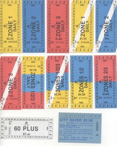
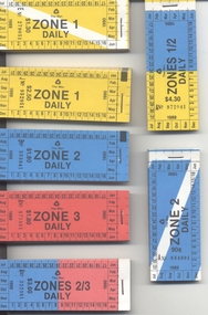
Ephemera - Ticket/s, Public Transport Corporation (PTC), Set of 12 of The Met Daily tickets, 1989
Set of 12 of The Met Daily tickets for use between Jul 1989 and June 1990 - single tickets taken from blocks. .1. Zone 1 Daily – J952703 – $2.50 .2 Zone 2 Daily - B352061 - $1.80 .3 Zone 3 Daily - A871641 - $1.80 .4 Zone 1 Daily concession – E278205 - $1.30 .5 Zone 2 Daily concession – A984941 - 90c .6 Zone 3 Daily concession – A998301 - 90c .7 Zones 1, 2 and 3 – Daily – A910061 - $5.30 .8 Ditto – concession - B315841 - $2.00 .9 Zones 1 and 2 – Daily – A972061 - $4.30 .10 Zones 2 and 3 Daily – A323801 - $3.60 .11 60 Plus daily – E753021 - $1.00 .12 City Saver – A184901 - $5 with a map of the available CBD area on the back. - has space for 10 punch marks. Used mid 1980's. Items .1 to .11 are all July 1989 to Jun 1990, with dates along the sides.trams, tramways, tickets, the met, ptc -
 Melbourne Tram Museum
Ephemera - Ticket Blocks, Public Transport Corporation (PTC), Set of 12 blocks of The Met Daily tickets, 1989
Set of 12 blocks of The Met Daily tickets for use between Jul 1989 and June 1990 All blocks of 20 tickets except the Zone 1 daily and daily concession which are blocks of 50. Each block stapled at the top to one or two staples, to a stub and heavy brown cardboard backing. .1. Zone 1 Daily – J952951 to 953000 – $2.50 .2 Zone 2 Daily - B353041 - 60 - $1.80 .3 Zone 3 Daily - A871661 - 80 - $1.80 .4 Zone 1 Daily concession – E279051 - 100 - $1.30 .5 Zone 2 Daily concession – A984901 - 20 - 90c .6 Zone 3 Daily concession – A998121 - 40 - 90c .7 Zones 1, 2 and 3 – Daily – A910001 - 20 - $5.30 .8 Ditto – concession B 315621 - 40 - $2.00 .9 Zones 1 and 2 – Daily – A972041 - 60 - $4.30 .10 Zones 2 and 3 Daily – A322981 - 323000 - $3.60 .11 60 Plus daily – E752021 - 40 - $1.00 .12 City Saver – A185041 - 60 - $5 with a map of the available CBD area on the back. - has space for 10 punch marks. Items .1 to .11 are all July 1989 to Jun 1990, with dates along the sides. See also Reg item 258 for other examples.trams, tramways, tickets, the met, ptc -
 Melbourne Tram Museum
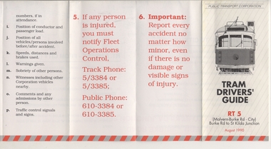
Pamphlet, Public Transport Corporation (PTC), "Tram Drivers' Guide RT 5", Aug. 1990
Pamphlet for tramcars, sheet of paper folded into pocket size, 12 folds, printed on gloss paper with black and red colours titled "Tram Drivers' Guide RT 5", providing g a map for the Route 5 Malvern Bourke Road from Burke Road to St Kilda Road, showing notes for both directions, compulsory stops, facilities and features. On the reverse side, has notes regarding classes of tram, information about accidents and telephone numbers. Dated August 1990. 2nd copy added 11-12-17 from Donation of Ron Scholten.trams, tramways, ptc, malvern burke rd, accidents, tram drivers, map -
 Melbourne Tram Museum
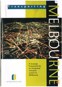
Book, Department of Infrastructure (DOI), "Transporting Melbourne - a Strategic framework for an integrated transport system in Melbourne", Sep.1996
Book - 92 pages, centre stapled, printed on gloss paper titled "Transporting Melbourne - a Strategic framework for an integrated transport system in Melbourne", issued September 1996. Has a message from Minister Alan Brown - Minister for Transport and Geoff Craige Minister for Roads and Ports. Looks at the strategic context, the system, integration and land use, public transport needs and reforms, road networks, industry, management, environmental sustainability and structural reform. Includes chapters on trams and buses. Has many figures and maps. 613.1 - Book - 28 pages centre stapled, printed on gloss paper titled "Transporting Melbourne - A summary for public consolation" issued Sept. 1996, summary of above document. Full pdf image of the book added.trams, tramways, melbourne, public transport, transport -
 Melbourne Tram Museum
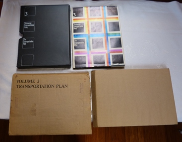
Document - Report, The Metropolitan Transportation Committee, "Melbourne Transportation Study - The Transportation Plan - Volume 3", 1969
Report titled "Melbourne Transportation Study - The Transportation Plan - Volume 3", presented in a black vinyl covered slip case, paper cover, bound, sewn with end papers, fold out maps, 74 pages. Each sheet within the report has rounded edges. Contained within a printed cardboard packing case. Includes many tables, graphs, charts and coloured sheets. Report prepared by The Metropolitan Transportation Committee - 1969, looking at the planning of all forms of transport for Melbourne with a timeframe of 1985. Chaired by Vernon Wilcox, Minister of Transport. Included Robert Risson - Chairman of MMTB. Set the basis for a very extensive freeway system that was only partly followed. Includes trams, trains (city loop), buses, parking, travel and population predictions, costs and implementation.Has numerous AETA stamps throughout the book. Inside front cover and on packing case "A12" in red ink.trams, tramways, melbourne, road transport, tramways, railways, public transport, transportation plan -
 Melbourne Tram Museum
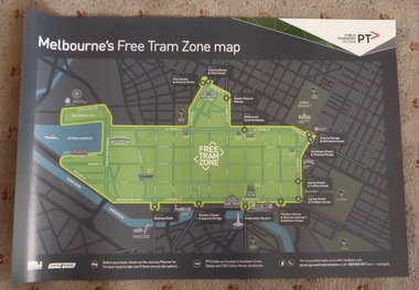
Poster, Public Transport Victoria (PTV), "Melbourne's Free Tram Zone Map", Sep. 2014
... Trams tramways Yarra Trams PTV Maps Free Tram Melbourne Set ...Set to two full colour posters printed on a plasticized based sheet, titled ""Melbourne's Free Tram Zone Map". 626.1 - Poster showing the tram lines that the free travel is allowed, locations, land marks, contact numbers and has the PTV logo in the top right hand corner. 626.2 - Poster showing the logo or tram stop id that the free tram zone travel applies to. See Reg Items 1954, and 1956 for associated printed materials and 2790.2 for driver announcements.trams, tramways, yarra trams, ptv, maps, free tram, melbourne -
 Melbourne Tram Museum
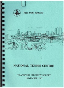
Document - Report, Dennis Johnston and Associates, Road Traffic Authority, "National Tennis Centre - Transport strategy Report November 1987", 1987
Report - 35 pages, within light blue covers, comb bound with black binder, titled "National Tennis Centre - Transport strategy Report November 1987". Report looks at the then planned Tennis Centre precinct and use of public transport in order to access it. It includes coach and car parking and how to handle various modes. Includes the MCG carpark, maps, parking areas, walking paths, access points. At the time, the tram line was located in Batman Ave. Also includes notes on the public information campaigns. Produced with the assistance of the MTA. Report prepared by Dennis Johnston and Associates for the Road Traffic Authority.trams, tramways, public transport, tennis centre, melbourne, mta -
 Melbourne Tram Museum
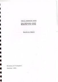
Document - Report, Ministry of Transport, "Public Transport Study - Port Melbourne, South Melbourne and St Kilda - Executive Report", Jan. 1983
... diagrams and maps. "Public Transport Study - Port Melbourne, South ...Report - 18 pages plus yellow card covers with brown comb binding titled "Public Transport Study - Port Melbourne, South Melbourne and St Kilda - Executive Report", prepared by the Ministry of Transport, January, 1983. Report looks at the patronage decline on the two heavy rail lines, transport in the area, patronage, comparison of possible services, operating costs, vehicles, bus services, traffic priority and possible light rail services. Has diagrams and maps.trams, tramways, st kilda, port melbourne, light rail, conversion, transport -
 Melbourne Tram Museum
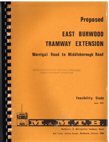
Document - Report, Melbourne & Metropolitan Tramways Board (MMTB), "Proposed East Burwood Tramway Extension - Warragul Road to Middleborough Road - Feasibility Study, Sep. 1974
Report - 68 pages, photocopied onto light cartridge paper with brown covers both sides, overlain with clear plastic covers and black comb bound. Titled "Proposed East Burwood Tramway Extension - Warragul Road to Middleborough Road - Feasibility Study June 1974", looks at the purpose of the extension, possible patronage, construction details, costs, existing services and impact on these, proposed services, operating costs, revenue and social benefit - cost analysis. Has many tables, diagrams including fold out map. Showed that the benefit outweighed the costs of the project. Prepared by the MMTB June 1974 - report on front page notes it is Amendment A, September 1974.Stamped "Australian Electric Traction Association Public Transport Committee" on both cover and inside front page.trams, tramways, burwood, east burwood, feasibility study, new tramway, mmtb, middleborough rd -
 Melbourne Tram Museum
Poster, Yarra Trams, CBD and inner city tram routes, January 2012
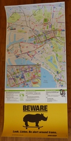
... Trams tramways Yarra Trams Maps PTV Melbourne Public Transport ...Full colour poster printed on a vinyl plasticized based sheet showing all the public transport routes to the north and south of the CBD, includes major landmarks. Has information on where to buy tickets, customer information and tram tracker. At the base has a Beware Rhino's image. Has the Melway image as well. Dated Effective - January 2012.trams, tramways, yarra trams, maps, ptv, melbourne, public transport, rhinos -
 Melbourne Tram Museum
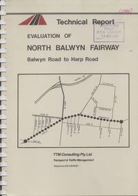
Document - Report, TTM Consulting, "Evaluation of North Balwyn Fairway, Balwyn Road to Harp Road", May. 1985
Approx a 70 page, comb bound, report by TTM Consulting in May 1985, titled "Evaluation of North Balwyn Fairway, Balwyn Road to Harp Road" for the Public Transport Corporation. Evaluates the impact of a Fairway along the North Balwyn tram route. Principal conclusions given on page - tram travel times in both AM and PM peaks were virtually unchanged. Document has many tables at rear, graphs and maps.Stamped on cover and inside page "Discarded from PTC Library 19 Oct 1989" and "1985" in red ink on front cover.trams, tramways, north balwyn, fairways, traffic control, tram priority -
 Melbourne Tram Museum
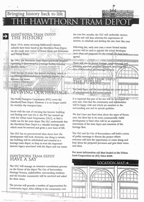
Document - Report, Minister of Transport, "Bringing history back to life - The Hawthorn Tram Depot", Aug. 1998
Report - consultation document titled - "Bringing history back to life - The Hawthorn Tram Depot", 7 A4 sheets, photocopied, outlining the joint Public Transport Corporation (PTC) and Urban Land Corporation (ULC) study into the future of the Hawthorn Tram Depot. Includes a site plan or location map, consultation proposals, news release from the Minister for Transport - Mr Robin Cooper - dated 12/8/1998 and background document providing details of some of the heritage trams - both the PTC and the TMSV. Two copies held - one stapled. Imaged as a pdf file.trams, tramways, hawthorn depot, heritage, minister for transport, tram depot -
 Melbourne Tram Museum
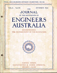
Magazine, Engineers Australia, Journal of the Institution of Engineers Australia" - Vol 6, No. 10, Oct. 1934, "Metropolitan and Provincial Tramways", Oct. 1934
Journal or magazine - stapled pages approx. 100 printed on semi gloss paper, with glue outside cover, titled Journal of the Institution of Engineers Australia" - Vol 6, No. 10, Oct. 1934 - Special issue - Melbourne Centenary Celebrations 1934 - 1935. Contains transactions of radio frequency, institution and related activities, and 100 years of Engineering in Victoria. These include maps of Victoria and Melbourne, Engineering Education (Kernot), Metropolitan Roads and Bridges by J. Noble Anderson City Engineer of Richmond, Country Roads and Bridges, Railway Development (VR), Metropolitan and Provincial Tramways (Strickland and Russell), Port of Melbourne, Outer ports, air transport, water supply, sewerage and drainage, gas industry, electricity supply, communications (telephone and telegraph), industrial development and mining. Has ads for British Insulated cables, Thompsons Engineer, Goodyear, GEC - British General Electric, Associated General electric, Vickers and many other companies. Photocopy of article from the Bob Lilburn collection.trams, tramways, centenary, victoria, tramways, railways, secv, mmtb, cable trams -
 Bendigo Military Museum
Booklet - A survey of the North Australian Coast on AK121 Aroetta, NT Force, NT Coastal Recce Unit RAE, 6 Aust Army Topo Survey Corps, AKA121 Aroetta, 28 Mar 1945
The work of the Australian Survey Corps is to make maps for the Army. At the outbreak of war very little of the mainland had been mapped, especially the northern parts. The best maps in existence of the N.T. coast in Dec "41 were those made by Matt Flinders in 1801 -1802. The Army soon got out new maps of all important areas including much of the inland. Later it was decided to bring the complete coastline up to date. Several parties put in between them six months on the coast during the dry season of "45 but a couple more months would be needed to complete the program when the "wet" interrupted the work. A small section from Buckingham Bay - Groote Eylandt was still untouched and this diary covers that section of the N.T. Coast. A survey party of four men was chosen who were to be transported from place to place by the AK121 Aroetta - a ketch of 25 tons belonging to an army unit called N.T. Coastal Recce whose work it was to patrol the coast and as well do air - sea rescue. The survey party: Lieut Jack Worsley (the Loot) Sgt Jack Love, Spr Jack Cook, Spr Pat Hede. Crew of Aroetta: Liet Ralph Warne (Skipper), Sgt Buckley (Buck) (First Mate and Orderly Rm), Sgt Jim Terjesen (Jumbo) Bosun, WO2 Tom Davis (Engineer), Cpl Kevin Monk (Artificer), L/Cpl Jack Cox (Deck Hand), Spr Jack Andrews (Signals), Spr Laurie Rament (Ass. Engineer), Spr McKenzie (Mac) (Cook). The complete history is not available after July 31 1945. The remainder of the notes are very badly water-damaged and in some places unreadable.A4 Booklet, plain paper with text and diagrams and half tone photograph of Lt Jack Worsley with plastic binderSigned by George Barton Maj. for LtCol GS. NT Forceroyal australian survey corps, rasvy, fortuna, army survey regiment, army svy regt, asr -
 Lakes Entrance Historical Society
Book, Bird, Eric and Lennon, Jane, Making an Entrance- The Story of the artificial entrance to the Gippsland Lakes, 1989
Revised edition of an earlier publication 'The Entrance to the Gippsland Lakes'. Contains illustrations, Maps, Diagrams timed for the centenary of the opening of the artificial entrance at Lakes Entrance VictoriaRevised edition of an earlier publication 'The Entrance to the Gippsland Lakes'. Contains illustrations, Maps, Diagrams timed for the centenary of the opening of the artificial entrance at Lakes Entrance Victoriaexploration, coast, transport, civil engineering -
 Victorian Railway History Library
Booklet, New South Wales Public Transport Commission, The Story of the Eastern Suburbs Railway, 1991
A history of the building of the Eastern suburban railway in Sydney New South Wales.ill, maps, p.15.non-fictionA history of the building of the Eastern suburban railway in Sydney New South Wales.railway rollingstock - new south wales, electric trains - new south wales - history -
 Vision Australia
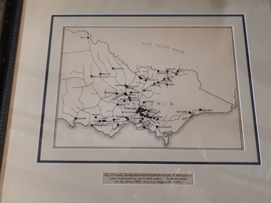
Map - Object, Victorian railways map
A black and white map of Victoria showing the railway lines where mail is transported and the individual towns listed next to the dot that provides location of such. Underneath is written "Map of Victoria showing the localities beyond the suburbs of Melbourne to which library books are sent to blind members. Books are carried over the railways FREE there is no charge to the readers." Through the work of Tilly Aston, braille postage was provided free by the Victorian Railways which greatly assisted the Braille Library in reaching members who resided outside of Melbourne. This map was produced to show the extent of the work by the Victorian Association of Braille Writers and the need for reading materials across the state.Paper of Victorian railway lines mounted in framevictorian association of braille writers, marketing -
 Lakes Entrance Historical Society
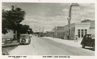
Postcard - Central Hotel Lakes Entrance, The Rose Series, 1940 c
Also another copy 01181.1Black and white postcard of the Main Street. Local map on the left hand side of scene. Spanish style Central Hotel in the right foreground. Motor cars on roadway, and pedestrians in summer clothing on paths. Lakes Entrance Victoriahotels, tourism, transport -
Lakes Entrance Historical Society
Book, Orbost Historical Society Inc, Barns of the Snowy River Orbost, 2006
Documents the distinctive slatted barns of the Lower Snowy River, Orbost, Victoria. Includes sketch maps, barn plans, history of area and families and personal ineterviews.Ngaire Donald May Leatchland settlement, agriculture, natural disasters, transport -
 Victorian Railway History Library
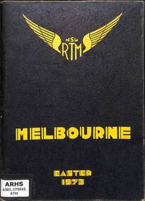
Book, The New South Wales Rail Transport Museum, Melbourne Easter 1973, 1973
A tour program detailing the route and travel information for the special train from Sydney to Melbourne with 3801 and 3820 run by the New South Wales Rail Transport Museum over the Easter holidays in 1973.maps, p.52.non-fictionA tour program detailing the route and travel information for the special train from Sydney to Melbourne with 3801 and 3820 run by the New South Wales Rail Transport Museum over the Easter holidays in 1973.railroad preservation - victoria - history, tourist trains - victoria - history -
 Whitehorse Historical Society Inc.
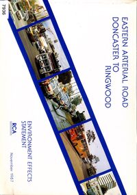
Book - Government Environment Effects Statement, Road Construction Authority (now part of VicRoads), Eastern Arterial Road - Doncaster to Ringwood, November 1987
The book covers the Environment Effects Statement for the Eastern Arterial Road Extension from Doncaster to Ringwood and the Ringwood Bypass. Aspects covered are development works, traffic affects, public transport, landscape and visual affects, noise, pedestrian/ bicycle access, lighting, air quality and construction affects. Includes maps, cross sections, photos.The book covers the Environment Effects Statement for the Eastern Arterial Road Extension from Doncaster to Ringwood and the Ringwood Bypass. Aspects covered are development works, traffic affects, public transport, landscape and visual affects, noise, pedestrian/ bicycle access, lighting, air quality and construction affects. Includes maps, cross sections, photos.non-fictionThe book covers the Environment Effects Statement for the Eastern Arterial Road Extension from Doncaster to Ringwood and the Ringwood Bypass. Aspects covered are development works, traffic affects, public transport, landscape and visual affects, noise, pedestrian/ bicycle access, lighting, air quality and construction affects. Includes maps, cross sections, photos.eastern freeway extension, eastern arterial road, mullum mullum creek, road construction, environmental impact -
Port Melbourne Historical & Preservation Society
Card - Binder, Piers Festival, Polly Woodside Maritime Museum, c. 1990
These migrant ship cards were used loose by the former Maritime Museum (Polly Woodside), and donated to PMHPS by A Gibson, National Trust Victoria, bound in January 2013 for use in the PMHPS display on migrant ships in Princes Pier GatehouseOne of three sets of laminated information cards, punched and roughly bound into a book for information display at "Piers festival". (.01) - "Angelina Lauro" to "Esperance Bay" (.02) - "Fairsea" to "Moreton Bay" (.03) - "Northern Star" to "Stathmore"The backs of the cards are pasted with sections of nautical maps.transport - shipping, immigration, celebrations fetes and exhibitions, angelina lauro, arcadia, australis, canberra, captain cook, captain hobson, castel felice, chusan, dominion monarch, ellinis, esperance bay, fairsea, fairstar, fairsky, galileo galilei, himilaya, johan van olden barnevelt, largs bay, maasdam, mariposa, moreton bay, northern star, orion, oriana, oronsay, ormonde, orsova, otranto, patris, roma, southern cross, stathaird, statheden, stathmore, ss iberia, ss guglielmo marconi -
Stawell Historical Society Inc
Map, Roads Maintained by NGSC. Roads Maintained by Other Authorities, C 2020
Printed Colour map of Norther Grampians Shire, with roads marked in colourNorther Grampians Shire COuncil. 1:200,000shire, roads, transport