Showing 545 items
matching vegetation
-
 Lakes Entrance Regional Historical Society (operating as Lakes Entrance History Centre & Museum)
Postcard, Stanley Vogt, 1910c
Paired with image 03731.1 for display in 150 years Lakes Entrance 1858 to 2008 held in October 2008Sepia toned postcard west side of Red Bluff showing a group of eight men and five women and a child. Sand washed away exposing vast rocky beach, short vegetation on rocky bluff. Women wearing full length skirts and wide brim hats with veils, men in three piece suits dark in colour on ninety mile beach Lake Tyers VictoriaThe Bluff Lakes Entrancebusinesses -
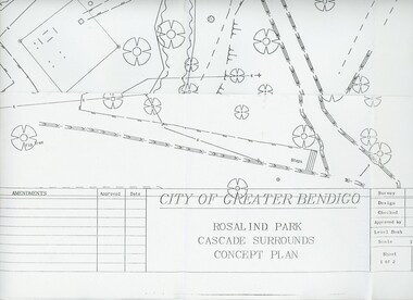 Bendigo Historical Society Inc.
Plan - MERLE HALL COLLECTION: ROSALIND PARK CREATIVE VILLAGE BENDIGO PROJECT CONCEPT PLAN, 1993
MERLE HALL COLLECTION: ROSALIND PARK CREATIVE VILLAGE BENDIGO PROJECT Concept Plan City of Greater Bendigo Rosalind Park Cascade Surrounds Concept Plan number GB095 Sheet 1 of 2 Level Book 365, Backup No Tape 01, Computer File No. ROS QEO. Large Sheet which shows the location of utilities, vegetation, drains, embankments etc. June 1993 -
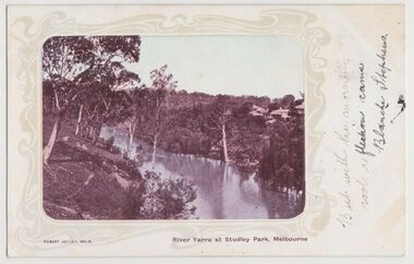 Kew Historical Society Inc
Postcard, River Yarra at Studley Park, Melbourne, 1900-04
Monochrome postcard titled lower right: “RIVER YARRA AT STUDLEY PARK, MELBOURNE”. The postcard was produced by ROBERT JOLLEY, MELB, (active 1900-1904). The photo is positioned to the left of the card and framed by an art nouveau design. A handwritten annotation on the front reads “BUT WITH THE MORNING / COOL REFLECTION CAME / BLANCHE STEPHENS”. On the reverse, there is a handwritten address in black ink to: MISS L STEPHENS / 26 WEST TERRACE / ADELAIDE. There is no division on the reverse of the postcard, dating it to before 1905. It lacks a postage stamp and postmark. Monochrome postcard of the River Yarra in Studley Park. The view is of the Yarra and its banks, with Kew on the left and Abbotsford on the right, as it appeared in the years 1900-1904. On the Abbotsford side of the river, there are a number of weeping willows lining the banks and houses on the hillside. The Studley Park side of the river includes some remnant vegetation and meandering walking tracks. Three very small figures are sitting on the Kew side. "RIVER YARRA AT STUDLEY PARK, MELBOURNE"river yarra -- kew (vic.), postcards -- kew, postcards -- studley park, robert jolley -
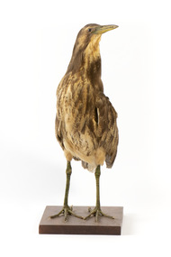
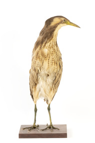 The Beechworth Burke Museum
Animal specimen - Australaisn Bittern, Trustees of the Australian Museum, 1860-1880
The Australaisn Bittern is a partly nocturnal bird who resides in costal and sub-coastal locations in south-west mainland Australia, south east Australia and Tasmania. They can be found in wetlands, swamps and among reeds. These birds are mostly brown and yellow in colour and with short legs and a stocky body. The "woomph" sound made by the Bittern late at night is thought to have been the origin of the traditional Aboriginal myth of the Bunyip. The Bunyip, like the Australasian Bittern, was believed to reside in reedy swamps. This specimen is part of a collection of almost 200 animal specimens that were originally acquired as skins from various institutions across Australia, including the Australian Museum and the National Museum of Victoria, as well as individuals such amateur anthropologist Reynell Eveleigh Johns between 1860-1880. These skins were then mounted by members of the Burke Museum Committee and put-on display in the formal space of the Museum’s original exhibition hall where they continue to be on display. This display of taxidermy mounts initially served to instruct visitors to the Burke Museum of the natural world around them, today it serves as an insight into the collecting habits of the 19th century. This specimen is part of a significant and rare taxidermy mount collection in the Burke Museum. This collection is scientifically and culturally important for reminding us of how science continues to shape our understanding of the modern world. They demonstrate a capacity to hold evidence of how Australia’s fauna history existed in the past and are potentially important for future environmental research. This collection continues to be on display in the Museum and has become a key part to interpreting the collecting habits of the 19th century.The Australaisn Bittern is a stocky bird with mainly yellow and brown colouring. This colouring makes the bird difficult to see in the dense, reedy vegetation it resides amongst in shallow freshwater wetlands. When threatened, the Australaisn Bittern will raise its bill skyward in a pose which helps it camouflage. This specimen has streaked yellow-brown feathers, a yellow bill and legs which are a yellow-green colour. It stands on a wooden platform.taxidermy mount, taxidermy, animalia, burke museum, beechworth, australian museum, skin, reynell eveleigh johns, bird, bunyip, myths, australaisn bittern, bittern -
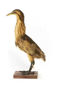 The Beechworth Burke Museum
Animal specimen - Australasian Bittern, Trustees of the Australian Museum, 1860-1880
The Australaisn Bittern is a partly nocturnal bird who resides in costal and sub-coastal locations in south-west mainland Australia, south east Australia and Tasmania. They can be found in wetlands, swamps and among reeds. These birds are mostly brown and yellow in colour and with short legs and a stocky body. The "woomph" sound made by the Bittern late at night is thought to have been the origin of the traditional Aboriginal myth of the Bunyip. The Bunyip, like the Australasian Bittern, was believed to reside in reedy swamps. This specimen is part of a collection of almost 200 animal specimens that were originally acquired as skins from various institutions across Australia, including the Australian Museum and the National Museum of Victoria, as well as individuals such amateur anthropologist Reynell Eveleigh Johns between 1860-1880. These skins were then mounted by members of the Burke Museum Committee and put-on display in the formal space of the Museum’s original exhibition hall where they continue to be on display. This display of taxidermy mounts initially served to instruct visitors to the Burke Museum of the natural world around them, today it serves as an insight into the collecting habits of the 19th century. This specimen is part of a significant and rare taxidermy mount collection in the Burke Museum. This collection is scientifically and culturally important for reminding us of how science continues to shape our understanding of the modern world. They demonstrate a capacity to hold evidence of how Australia’s fauna history existed in the past and are potentially important for future environmental research. This collection continues to be on display in the Museum and has become a key part to interpreting the collecting habits of the 19th century.The Australaisn Bittern is a stocky bird with mainly yellow and brown colouring. This colouring makes the bird difficult to see in the dense, reedy vegetation where it resides amongst the shallow freshwater wetlands. When threatened, the Australaisn Bittern will raise it's bill skyward in a pose which helps it to camouflage. This specimen has streaked yellow-brown feathers, a yellow bill and legs which are a yellow-green colour. It stands on a wooden platform.Paper tag: ...Bittern... [Catalogu]e, page 3...taxidermy mount, taxidermy, animalia, burke museum, beechworth, australian museum, skin, reynell eveleigh johns, bird, bunyip, myths, australaisn bittern, bittern -
 The Beechworth Burke Museum
Animal specimen - Australasian Bittern, Trustees of the Australian Museum, 1860-1880
The Australaisn Bittern is a partly nocturnal bird who resides in costal and sub-coastal locations in south-west mainland Australia, south east Australia and Tasmania. They can be found in wetlands, swamps and among reeds. These birds are mostly brown and yellow in colour and with short legs and a stocky body. The "woomph" sound made by the Bittern late at night is thought to have been the origin of the traditional Aboriginal myth of the Bunyip. The Bunyip, like the Australasian Bittern, was believed to reside in reedy swamps. This specimen is part of a collection of almost 200 animal specimens that were originally acquired as skins from various institutions across Australia, including the Australian Museum in Sydney and the National Museum of Victoria (known as Museums Victoria since 1983), as well as individuals such as amateur anthropologist Reynell Eveleigh Johns between 1860-1880. These skins were then mounted by members of the Burke Museum Committee and put-on display in the formal space of the Museum’s original exhibition hall where they continue to be on display. This display of taxidermy mounts initially served to instruct visitors to the Burke Museum of the natural world around them, today it serves as an insight into the collecting habits of the 19th century.This specimen is part of a significant and rare taxidermy mount collection in the Burke Museum. This collection is scientifically and culturally important for reminding us of how science continues to shape our understanding of the modern world. They demonstrate a capacity to hold evidence of how Australia’s fauna history existed in the past and are potentially important for future environmental research. This collection continues to be on display in the Museum and has become a key part to interpreting the collecting habits of the 19th century. This Australaisn Bittern is a stocky bird stylised in a standing position with brown colouring. This colouring makes the bird difficult to see in the dense, reedy vegetation it resides amongst in shallow freshwater wetlands. When threatened, the Australaisn Bittern will raise its bill skyward in a pose which helps it camouflage. This specimen has streaked yellow-brown feathers, a yellow bill and legs which are a yellow-green colour. It stands on a wooden platform.taxidermy mount, taxidermy, animalia, burke museum, beechworth, australian museum, skin, reynell eveleigh johns, bird, bunyip, myths, australaisn bittern, bittern -
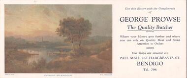 Bendigo Historical Society Inc.
Document - BENDIGO BUSINESSES COLLECTION: GEORGE PROWSE
Advertising material. Use this blotter with the compliments of George Prowse, the quality butcher. Where your money goes further and where you can rely on quality meat and strict attention to orders. Our shops situated at: Pall Mall and Hargreaves Street, Bendigo, tel 798. On the left a copy of a painting titled ''Evening Splendour'' by H. Henderson showing a country landscape with a small lake, trees and vegetation, the top of a church in the distance.bendigo, business, george prowse -
 Lakes Entrance Regional Historical Society (operating as Lakes Entrance History Centre & Museum)
Postcard, Bulmer H D, 1922c
Black and white photographic postcard, showing early aerial view of township of Lakes Entrance, Cunninghame Arm, North Arm and sand dunes, ocean in lower foreground, Eastern wharf and various boats on lake. Princes Highway went along Esplanade, Myer Street and Roadknight Street, very little vegetation on sand dunes, no foot bridge yet, good view of North Arm, few houses. Lakes Entrance VictoriaLakes Entrance and Backwater from the Air.islands, aerial photograph, waterways, topography, township -
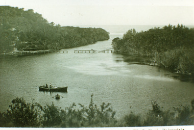 Lakes Entrance Regional Historical Society (operating as Lakes Entrance History Centre & Museum)
Photograph, Vogt, W S, 1920
Also one enlarged copy 20.5 x 28.5 cm|Also one copy 12 x 17|Also giant colour postcardBlack and white photograph showing view of Lakes Bunga, near Lakes Entrance. Tramline across lake shows beginnings of disrepair, one panel gone, another panel broken, two row boats on lake, larger one contains two adults and four children, smaller row boat has one small child. Entrance appears to be closed, thick vegetation around lake. Lake Bunga VictoriaLake Bunga (Northrope's), W S Vogt, Bairnsdalewaterways, topography, bridges -
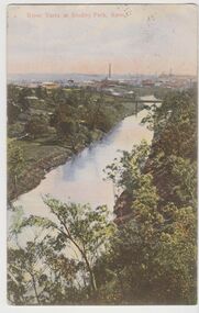 Kew Historical Society Inc
Postcard, River Yarra at Studley Park, Kew, c.1908
Colour-tinted postcard, titled in red upper left: “RIVER YARRA AT STUDLEY PARK, KEW”. On the divided reverse, the card is addressed to “MISS JOLLEY / MELB. TRAM & O[MNIBUS]. CO / BOURKE STREET, MELB”. The sender has dated the card 21.12.08. In the upper right corner, there is a pink Victorian one penny postage stamp; sent from Melbourne on 22DE 08. (The division of the reverse of the postcard, allowing a message to be written on one half and the address on the other, was not permitted in Australia until 1905.) The manufacturer of the postcard is indicated by the initials “W.T.P”, printed in a green floral diamond, printed centre top. This was the trademark of WT Pater, printers & stationers. William Thompson Pater was born in Melbourne in 1861. His business at 271 Little Collins Street offered Christmas cards, booklets, calendars, and leather goods as well as postcards and albums.Hand-tinted postcard of the River Yarra in Studley Park, Kew. The birds-eye view is of a bridge on the Yarra (Johnston Street?) linking Kew and Abbotsford as it appeared in c.1908. On the Abbotsford side of the river, fields lead down to the river, with some remnant trees. The Kew side of the river, in contrast, due to its steep banks, retains its original vegetation. In the distance is industrial development, in what might be Fairfield and Alphington.“RIVER YARRA AT STUDLEY PARK, KEW”river yarra -- kew (vic.), william thompson pater, w.t.p., postcards -- kew, postcards -- studley park, bridges - yarra river -- kew (vic.) -
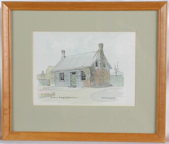 Glenelg Shire Council Cultural Collection
Painting, Ruth Denny, Gardens Cottage Portland 1857, 1967
CEMA Art collectionThe painting depicts a blue stone building with green door. On either side of the door is a window and there is a chimney at either end of the roof. The side of the house closest to the viewer is overgrown with vegetation which extends up to and covers the chimney. To the right of the building is a green fence with a leaf-less tree behind. To the left of the building is a smaller green fence with several green trees behind. The work has a plain wooden frame with a mount and glass.Front: Gardens Cottage Portland 1857 Ruth Denny 1967 (black, handwritten) Back: Sticker: DEANS MU 8291 FOR FRAMING 346 LT. COLLINS ST., MELB. NO. 20438 Yellow sticker: 3033portland, female artist, female, women, botanic gardens, curator's cottage -
 Kew Historical Society Inc
Map, Robert Russell, Map Shewing the Site of Melbourne and the Position of the Huts & Buildings Previous to the Foundation of the Township by Sir Richard Bourke in 1837
Map shows the first layout of Melbourne by Government surveyor Robert Russell, who accompanied Governor Richard Bourke in 1837. The surveyed blocks extend from present-day Flinders Street to Lonsdale Street, and Spring Street to Spencer Street, with extensive vacant land west to a salt lake (afterwards Batman's Swamp, later drained), north beyond Flagstaff Hill and south towards South Melbourne. Vegetation coverage is indicated, and tracks and existing buildings and cultivated land are shown.Printed map was created by Day & Haghe, Lithographers to the Queen, sometime after 1838, when the company received its Royal appointment. Copies of the 1837 map exist in several major map collections in Australia; most are uncoloured. This particular map is the earliest in the Kew Historical Society's map collection. It is a nationally significant artefact. Black and white lithographed map hand-coloured in blue and yellow gouache of the town of Melbourne in 1837. In contrast to the original lithograph, the river and the township blocks are coloured blue and yellow. A similar, partly coloured copy is in the collection of the University of Melbourne.maps - melbourne - 1830s, governor sir richard bourke, robert russell - surveyor, cartography -
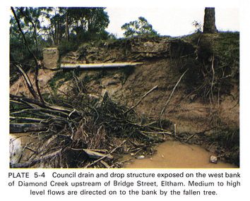 Eltham District Historical Society Inc
Work on paper (Sub-Item) - Photograph, Council drain and drop structure exposed on the west bank of Diamond Creek upstream of Bridge Street, Eltham
Colour photograph of a muddy creek (probably after a downpour) showing council drain and drop structure exposed on the west bank of Diamond Creek upstream of Bridge Street, Eltham. Mediun to high level water flows are directed on to the bank by the fallen tree.eltham, creek, diamond creek, bridge street, drainage, waterflow, vegetation -
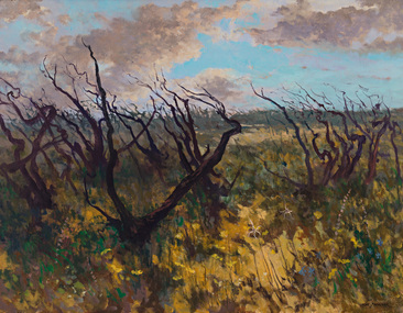 Bayside Gallery - Bayside City Council Art & Heritage Collection
Painting - oil on canvas, Max Sherlock, Rebirth at Aireys, c. 1984
aireys inlet, aireys, rebirth, bush fire, vegetation, tree, max sherlock -
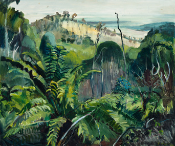 Bayside Gallery - Bayside City Council Art & Heritage Collection
Painting - oil on canvas, Elizabeth Prior, Passage - Dandenongs, 1974
landscape, dandenongs, trees, ferns, hill, vegetation, elizabeth prior -
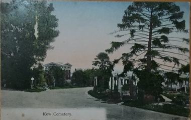 Kew Historical Society Inc
Postcard, Unknown, Kew Cemetery, 1905
This view of the Boroondara General (Kew) Cemetery is dated to 1905 by the inscription and postmark on the reverse. It provides an important visual record of this part of the Cemetery. The postcard can be used to identify the original configuration of the roads and vegetation, some of which was subsequently removed (eg the bunya pine at right). On the Victorian Heritage Database, the construction period given for the Springthorpe Memorial is given as 1897-1907, yet this view of the Memorial in 1905 would suggest that it was virtually completed at an earlier date. (It should be noted that additions such as the wheel of life sculpture were not completed until 1910).This dated photograph is historically important as its inscription confirms it to be one of the earliest postcard representations of the Boroondara General (Kew) Cemetery. It also provides visual evidence of the size and extent of the landscaping by 1905, particularly the layout of the roads (now altered), plantings of the period, and the extent of the land occupied by the Springthorpe Memorial and its gardens, which was subsequently reduced by the trustees of the cemetery in the 1930s. Panoramic view of the entrance driveway in Boroondara General (Kew) Cemetery. At left can be seen the Springthorpe Memorial, and further down on the left the entrance gate, or one of the gates, to the Memorial. Inscribed on reverse: "Miss Brown / Shuan [sic] / Grosvenor Street / M. Brighton. Love from Mother Oct 28th 1905" Postmark: "Melbourne 8 / 2 PM, 28/10/05".springthorpe memorial, boroondara general (kew) cemetery, postcards -- cemeteries -
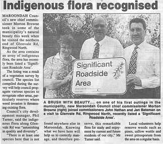 Ringwood and District Historical Society
Newspaper, Scrapbook Clipping, Library Collection, Ringwood, Victoria, `
``Newspaper clipping from "The Post", 23-8-95, P 2. Indigenous flora recognised Maroondah Council's new chief Commissioner Moreton Brown took in some of the municipality's natural beauty this week when he visited the northern end of Glenvale Rd., Ringwood North. As the area contains an array of indigenous flora, the area has recently been listed a "Significent Roadside Area". The listing was the result of a vegetation suvey by council. Pictured are: Jan Bateman, John Nathan and new Maroondah Chief Commissioner, Moreton Browne.` -
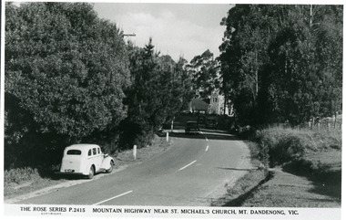 Mt Dandenong & District Historical Society Inc.
Photograph, Mountain Highway Near St. Michael's Church, Mt. Dandenong, Vic, c1950
Rose Series Postcard number 2415Copy of Rose Series post card taken c1950. St. Michael's Foundation Stone laid in 1940. Name 'Mountain Highway" is incorrect as the Mountain Highway was the Sassafras - Basin Road though it may not have received that name by 1950. The correct name is the Mount Dandenong Tourist Road at Mt. Dandenong / Kalorama as Falls Road is the boundary. Note: Heavy roadside vegetation, no white lines at side of road. White car probably pre war Vauxhall.kalorama, mount dandenong, rose series, st. michael's church, mt. dandenong tourist road -
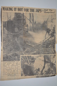 Wangaratta RSL Sub Branch
Newspaper Cutting, Making it hot for the Japs - and the mosquitoes!
Newspaper article reads - "Flamethrowers have a dual purpose for men of the AIF New Guinea - Above - an infantryman is burning out a Jap bunker during a successful attack on Mt Shiburangu in the Wewak area while At right - Pte T Nicholls of Bairnsdale (Vic) is shown using a flamethrower on mosquito-infested vegetation in the Maprik area. - Australian Official" Private T (Thomas) Nicholls of Bairnsdale - VX 80709 2/6 Aust Infantry Battalion Born 22/3/1923 Died 7/7/1945 buried at Lae Cemetery PNGCut out newspaper article containing two photographs with short story bottom left hand corner.Making it hot for the Japs - and the mosquitoes!flamethrower, new guinea, ww2, thomas nicholls, 2/6 aust. infantry battalion, lae -
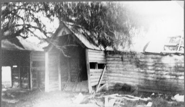 Stawell Historical Society Inc
Photograph, "Ashen" Homestead Remnants in Murtoa after a Storm c1920’s
Dugald McPherson's Ashen's Homestead (Remnants) c1920’s Ashen's south of Murtoa was one of the area's original squatting runs. This photo taken in the 1920's shows the homestead after a violent storm had been through the area. In 1853, the country around Ashen's was covered by timber, she-oaks, bull-oaks, light gum and box thickets of ti-tree and clumps of pine and wattles. The vegetation was so thick outside the horse paddock it was difficult to move in any direction. It was said McPherson and two others fought over the land.Back entrance to Ashen's Station.stawell -
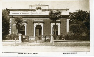 Stawell Historical Society Inc
Photograph, Stawell Shire Hall 1866
Post card of the Stawell Shire Hall built 1866. The Shire Hall in Longfield Street Stawell has seen many changes over time. The building originally had a brick facade as seen in this photo. The post card also shows the changes in vegetation around the building. In front of the two arched front windows of the building are two tall Dracaena's possible planted in c 1890's. The decorative fence was not in very early photographs of the building but appears in photographs around c 1890. The post card is located in Albun 14, p.9.Black & white post card of the Stawell Shire Hall. The building has a brick facade with trees in the background. In front of the two arched front windows of the building are two tall Dracaena's either side of the entrance. There is a decorative fence with posts either side of the entrance gates to the building. The post card is located in Albun 14, p.9.The Shire Hall, Stawell Victoria. Real Photo Series. M. 672. on the back Valentines real photo series POST CARD branches Sydney London Dundee Capetown Montreal Toronto all in a box. Published by the Valentine & Sons Publishing Co.Ltd. Melbourne, Sydney & Brisbane.stawell -
 Lakes Entrance Regional Historical Society (operating as Lakes Entrance History Centre & Museum)
Photograph, 1920c
Copied from copy in J Whadcoat collectionBlack and white photograph showing P W D cottage on left and other Works buildings on dune at the entrance to Gippsland Lakes from the ocean - Bass Strait. View shows flagstaff on top of dune and flagstaff jetty in lake - Cunninghame Arm. Small sailing boat on left and other small craft on shoreline. Section of Bullock Island with vegetation, one telegraph pole and one dead tree on island. Shoreline of North arm in foreground. Lakes Entrance Victoriajetties, township, waterfront, accommodation, waterways, ships and shipping -
 Kew Historical Society Inc
Photograph - The Boulevard at Kew, 1937
The Yarra Scenic Boulevard stretching from Hawthorn to the Chandler Highway was completed as a major project between 1933 and 1936 during a period of significant unemployment. Key dates in the construction this section the road include: 1933 when Kew Council supported the construction of the road from Studley Park to the Kew Asylum; and 1936 when the road from the Johnston Street Bridge to the Chandler Highway was opened. The inscription on the reverse of the photo 'Boulevard Fairfield' is misleading as there is no section of the Boulevard in Fairfield. A more likely interpretation is that it is a photograph of the Kew section of the Yarra Boulevard with the factories of Fairfield in the distance.Rare early photograph of the Yarra Boulevard, taken one year after the opening of the road. The photograph is an important historical record of the results of 'Susso' labor in the creation of major works in Melbourne by the Victorian Government. Original, black and white positive print of the Boulevard at Kew in 1937. Key aspects to note about the photograph is that the road is bituminised; that the gutters are concreted; that the kerb is constructed of concrete blocks; and that there is an unmade footpath on what appears to be the right hand side of the road. The landscape is sparsely treed, and those trees that remain are presumably remnant vegetation. At the right, the land is fenced. The land at the left falls away sharply to the river below. On the horizon, at left, there is an industrial complex including a tall chimney that is burning fuel creating smoke. "Boulevard Fairfield" great depression, susso projects, roads -- kew (vic.), yarra boulevard, yarra valley -
 Bayside Gallery - Bayside City Council Art & Heritage Collection
Painting - oil on canvas, Shannon Smiley, Beside the tracks, 2015
Shannon Smiley, Beside the tracks 2015, oil on canvas, 92 x 122 cm. Bayside City Council Art and Heritage Collection. Purchased 2017.oil on canvaslandscape, vegetation, trees, train tracks, painting, shannon smiley, photorealist, leaves -
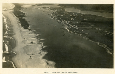 Lakes Entrance Regional Historical Society (operating as Lakes Entrance History Centre & Museum)
Photograph, 1923c
Two copies 16.5 x 25.5 very darkBlack and white photograph showing early aerial view of township of Lakes Entrance, photo shows highway going along Myer Street and along Roadknight Street, no shops in Myer Street appears to be no foot bridge, therefore taken prior to 1937, sparce vegetation on foreground dunes, four barriers built on dunes to stop erosion through sand, two masted sailing boat in lake. Bullock Island in distance appears very small, Snake Island of Rigby Island in centre distance. Lakes Entrance VictoriaAerial View of Lakes Entrancewaterways, coast, aerial photograph, islands -
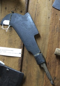 Mont De Lancey
Tool - Bill Hook, Unknown
Used in the 19th centuryA bill hook or axe-handled slasher which is an axe-handled forged metal blade with a strong curved sharp axe like edge and a straight secondary edge on the back. It has a broken wooden handle with steel or a tang which passed through the handle if it were still attached. There is stamped on the blade near the handle join - '2'. The original finish of the blade would have been, 'Japanned' which is baked black enamel. It was used to cut back scrub, small trees and woody vegetation in the 19th century.'2' stamped on the blade near where it joins the handle.slashers, cutting tools, bill hook slasher, gardening tools, agricultural tools -
Bendigo Historical Society Inc.
Document - MARKS COLLECTION: PARISH PLAN OF WHITE HILLS
Sepia coloured map showing allotments in Parish of Sandhurst (White Hills) Written on LH side of map town and Suburban Lots White Hills Parish of Sandhurst. Scale is shown in chains. Surveyed by Horage Walker. Photo lithographed at the Department of Lands & Survey, Melbourne by J.Noone, Price 1/-. 6th. January 1865. Map shows Race Course Reserve at top of sheet, Municipal boundary is marked on LH side. Comments re vegetation throughout map. For example, poor soil timbered with Box scrub.bendigo, planning, white hills parish map -
 Kew Historical Society Inc
Photograph - Willsmere [Kew] Billabong, 1993
Willsmere Park is bounded by the the Yarra River, Green Acres Golf Club, Willow Grove and the Eastern Freeway. The land on which the park is now situated was bought by Thomas Wills at the Crown Land Sales of 1846 (Section 56). From the 1840s to the 1940s it was intensively farmed. The park is dominated by very large playing fields, while planting to the southern boundary was undertaken when the Eastern Freeway was built. It is only along the banks of the Yarra that there is any remnant native vegetation. Willsmere Park is of significance as an area of open land that remains from the flood plain that once dominated northern Kew. (Source: Kew Conservation Study, 1988)Original colour small format polaroid photograph of the 'Kew Billabong' in the Willsmere Park, taken on 16 September 1993."Willsmere Billabong 16.9.93"kew billabong, willsmere park, yarra river -- billabongs -
 Kew Historical Society Inc
Photograph - Yarra River in flood at the Willsmere Park, 1993
Willsmere Park is bounded by the the Yarra River, Green Acres Golf Club, Willow Grove and the Eastern Freeway. The land on which the park is now situated was bought by Thomas Wills at the Crown Land Sales of 1846 (Section 56). From the 1840s to the 1940s it was intensively farmed. The park is dominated by very large playing fields, while planting to the southern boundary was undertaken when the Eastern Freeway was built. It is only along the banks of the Yarra that there is any remnant native vegetation. Willsmere Park is of significance as an area of open land that remains from the flood plain that once dominated northern Kew. (Source: Kew Conservation Study, 1988)Original colour small format polaroid photograph of the Yarra River in flood at the Willsmere Park, taken on 16 September 1993."Yarra River at Willsmere Park Flooding 16.9.93"willsmere park, yarra river -- floods -- kew (vic.) -
 Kew Historical Society Inc
Photograph - Flooding in the Willsmere Park, 1993
Willsmere Park is bounded by the the Yarra River, Green Acres Golf Club, Willow Grove and the Eastern Freeway. The land on which the park is now situated was bought by Thomas Wills at the Crown Land Sales of 1846 (Section 56). From the 1840s to the 1940s it was intensively farmed. The park is dominated by very large playing fields, while planting to the southern boundary was undertaken when the Eastern Freeway was built. It is only along the banks of the Yarra that there is any remnant native vegetation. Willsmere Park is of significance as an area of open land that remains from the flood plain that once dominated northern Kew. (Source: Kew Conservation Study, 1988)Original colour small format polaroid photograph of flooding in the Willsmere Park, taken on 16 September 1993."Flooding of shared path from Willsmere Billabong 16.9.93"willsmere park, yarra river -- floods -- kew (vic.), kew billabong