Showing 2592 items matching "76"
-
 Bacchus Marsh & District Historical Society
Map, O'Hagan v Shire of Bacchus Marsh, Allotment 5, Sec 16, Parish of Korkuperrimul
The purpose for this map being created or the date when it was made has not been established. It appears to be documentation relating to a legal dispute by a landowner named O'Hagan and the Shire of Bacchus Marsh. Features identified on the map are allotment 5, section 16, Parish of Korkuperrimul, a 'cultivation paddock', a section of the Werribee River, the path of a section of a 'Main Channel', and a barrier or filled in section across the Werribee River called 'Lee's Filling'. The O'Hagan is likely to be Patrick O'Hagan, 1829-1914 who arrived in Bacchus Marsh in 1864 and was a prominent citizen and landowner in the area for many years until his death in 1914.Single page map showing allotment 5, section 16 in the Parish of Korkuperrimul, Scale 4 chains to inch. Part of a set of maps which are pasted into a bound volume containing 76 maps or plans in total. High resolution digital image stored on BMDHS computer network. Stamped: Munzt, Bace and Muntz, Civil Engineers and Licensed Surveyors , 388 Collins Streetbacchus marsh victoria maps, water supply structures and establishments, watercourses -
 Uniting Church Archives - Synod of Victoria
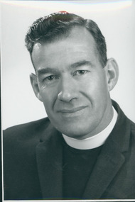
Photograph, Rev. R. B. Sparks, C. 1960s
Rev. Ronald B. Sparks, B.A. Ordained 1953. (WA) Maylands 1953–57; Canning Bridge 1957–62; AIM Kimberley Patrol 1962–65; Asst Superintendent AIM 1965–70; Mosman 1970–76; Parramatta 1976–.Head and shoulder portraits of a minister in clerical garb."Rev. R. B. Sparks"sparks, r. b. -
 Bendigo Military Museum
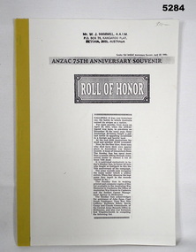
Book - BOOK - facsimile, Sunday Sun Newspaper - ANZAC Anniversary Souvenir April 22, 1990, "ANZAC 75th ANNIVERSARY SOUVENIR ROLL OF HONOR", 1990
ANZAC Roll of Honor. Published in Sunday Sun - 75th Anniversary of one Gallipoli campaign - Lists 7594 dead.Soft cover book - facsimile. Front cover - light cardboard, front cover black print on white background includes copy of newspaper article. Back cover - beige colour, yellow cloth tape binding. Pages - paper, cut, plain, white. One illustration - black print. Front cover top - owner's stamp.Front cover top - owner's stamp, black ink - "MR. W. J. HAMMILL, A.A.I.M./P.O. BOX 76, KANGAROO FLAT/VICTORIA, 3555, AUSTRALIA"books, history, anzac, ww1 -
 Seaworks Maritime Museum
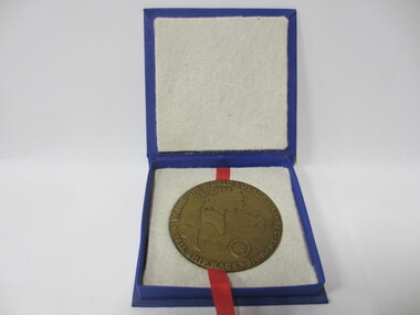
Medallion
Bronze mellion featuring image of ship on one side and map of the world on the other "Merchant Marine Academy/ Goynia/ Poland/ Dar Mzodzieey" Verso "Round the World Voyage/ Tall ship Races Hobart- Sydney" PMA 0291 WMA 76 -
 Flagstaff Hill Maritime Museum and Village
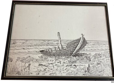
Drawing - Maritime, Cooper N (or Al), Artist, 726 Willpower, 1976
This framed drawing depicts a small vessel wrecked on the shore, resting on rocks, with sea in the background. The artist, Norm Cooper, created the drawing in 1976. He was a well-liked and respected local artist and surfer. The picture was framed in Warrnambool by Stuart Prince in the 1980s. Norm Cooper passed away in 1988. The Southwest Boardriders inaugural Norm Cooper Memorial contest, the 'Normie' , was held in 2015 in his honour, "celebrating the legacy of one of the region's most legendary surfers" (a quote from the Southwest Boardriders). The name of the vessel in the drawing, '726 Willpower', may represent one of several yachts that have the name 'Willpower'. The framer, Stuart Prince Picture Framing, was a local business, Prince was one of the owners of the Henna Street Picture Framers at 74 Henna Street, Warrnambool. He retired in 2019 after 22 years in the business.This line drawing's subject is a wrecked vessel, connected to the local theme of maritime history, the 'Shipwreck Coast'.Drawing, pen and ink line drawing on white paper, in black painted wooden frame with gilt border. Subject is a single masted vessel beached on rocks on shore, with two sailing ships on sea in background. Name on side of vessel is "726 Willpower". Inscription on front and back. Created in 1976, framed in 1980s. Artist was Norm Cooper. Framed in Warrnambool by Stuart Prince Picture Framing.Name on vessel: "726 WILLPOWER", Written on centre lower edge "N. Cooper '76" Stamped in black ink on backing paper: "STUART PRINCE PICTURE FRAMING"flagstaff hill, warrnambool, maritime village, maritime museum, flagstaff hill maritime museum & village, shipwreck coast, great ocean road, line drawing, 726 willpower, cooper, stuart prince, stuart prince picture framer, warrnambool picture framer, shipwreck 726 willpower, norm cooper, norm cooper memorial, the normie, southwest boardriders -
 National Wool Museum
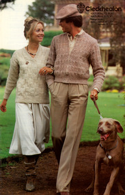
Booklet - Pattern Booklet, Cleckheaton Design 0036, Cleckheaton, 1980s
Four page fold out knitting pattern booklet featuring a colour image on the cover of a man and woman walking outdoors with arms linked, the man is also holding a dog on a lead.front: [printed] Cleckheaton / NATURAL 12 PLY/ / NATURAL 8 PLY / Design 0036 / Sizes: Jacket 90 - 120 cm / Jumper 76 - 97 cmknitting, pattern, fashion, knitwear, cleckheaton -
 Warrnambool and District Historical Society Inc.
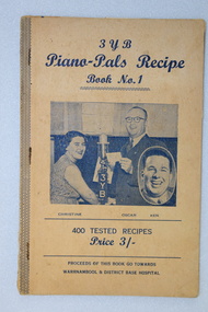
Book, 3YB Piano Pals Recipe Book No.1: 400 Tested Recipes/Price 3/-/Proceeds of this book go towards Warrnambool & District Base Hospital
Recipes sent in by listeners to the radio program Piano Time with the object being to raise money for Warrnambool & District Hospital , in support of 3YB's Annual Good Friday Hospital Appeal.Fawn colour soft-covered book with navy print; handwritten items on inside front and back cover; 76 pages; photo of female (Christine) and male (Oscar) presenter in the studio with 3YB microphone in the centre and an inset photograph of another presenter (Ken); recipes included provided by local listenersnon-fictionRecipes sent in by listeners to the radio program Piano Time with the object being to raise money for Warrnambool & District Hospital , in support of 3YB's Annual Good Friday Hospital Appeal.warrnambool, 3yb, hospitals, recipes, fundraising, oscar henry, christine benbow -
 Bendigo Historical Society Inc.
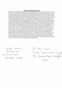
Document - BENDIGO EASTER FAIR COLLECTION: FIRST BENDIGO EASTER FAIR
1 page document, original. Document attributed to article written by David Horsfall. Written on bottom in pen - James Thompson, Bendigo Trust, 76 Violet Street, Bendigo 3550. Mr. Craig Tweed, Tweed Sutherland Pty Ltd., 52 Mitchell Street, Bendigo, Vic, 3550.bendigo, bendigo easter fair, first easter fair -
 Bendigo Historical Society Inc.
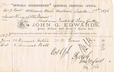
Document - ANCIENT ORDER OF FORESTERS NO. 3770 COLLECTION: JOHN G. EDWARDS
Account from John G. Edwards, Printer. 'Bendigo Independent' General Printing Office, dated October 1st 1876 for Funeral Notice June 23 1875 for W. B. Evans 4/- and Oct 2 1875 Annual Ball 7/-. Marked paid Oct 6/76.societies, aof, correspondence, ancient order of foresters no. 3770 collection - john g. edwards, bendigo independent general printing office, mr j best, court king of the forest, mechanics' institute, zjohn g edwards, w b evans -
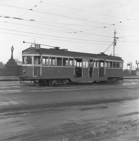 Ballarat Tramway Museum
Negative, Geoff Grant, 7/05/1955 12:00:00 AM
Negative No. 291 and colour print made by colour laser printer (stored in folder ) of W2 440 leaving Batman Avenue terminus on route 76 Camberwell Depot? on 7/5/1955. Photo by Geoff Grant. Hi res scan of negative and image updated 19/5/2020.trams, tramways, melbourne, batman ave, tram w2 440 -
 Tennis Australia
Ball container, Ball, Circa 1975
An unsealed Penn 'X-76 Extra Duty High Visibility' tennis ball can. Missing metal ring-pull seal lid. Has Wilson-branded plastic reclosure lid. Contains three matching Penn 1 balls. Materials: Metal, Ink, Synthetic material, Rubbertennis -
 Bacchus Marsh & District Historical Society
Map, Trentham Parish Map 1905 Copy 1
A single page paper map showing the map for the Parish of Trentham in the Counties of Dalhousie and Bourke. A cadastral map showing parish boundaries and land ownership. The map is pasted into a bound volume containing 76 maps or plans in total. High resolution digital image stored on BMDHS computer network. Photo-lithographed at the Department of Lands and Survey, Melbourne by T.F. McGauran 22.3.05 trentham parish maps, trentham parish plan, bacchus marsh region parish plans -
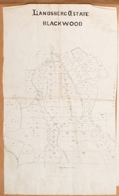
![Map, Late the Property of Robert Lawson Esq. [Landsberg Estate Blackwood]](/media/collectors/5e461d8021ea67224c82f2a1/items/67763722eb6d2cbd24dff14f/item-media/677637b7eb6d2cbd24dff29d/item-fit-380x285.jpg) Bacchus Marsh & District Historical Society
Bacchus Marsh & District Historical SocietyMap, Late the Property of Robert Lawson Esq. [Landsberg Estate Blackwood]
The date this map was created has not been identified. It was possibly created at the time the Landsberg Estate near Blackwood was subdivided and sold into smaller lots in December 1886. This land once belonged to Robert Lawson who died in 1869. Lawson was a well known school teacher who founded Scotch College in Melbourne before setting up a school near Blackwood. This map is similar to another map in the BMDHS collection titled 'Landsberg Estate Blackwood' Victorian Collections record 459 and was possibly produced at the same time.Single page map showing land allotments which made up the Landsberg Estate near Blackwood. Scale 20 chains to 1 inch. The map is pasted into a bound volume containing 76 maps or plans in total. High resolution digital image stored on BMDHS computer network. At the top of the map: 'Late the Property of Robert Lawson Esq.'bacchus marsh victoria maps, landsberg estate blackwood -
 Bacchus Marsh & District Historical Society
Map, Landsberg Estate Blackwood
The date this map was created has not been identified. It was possibly created at the time the Landsberg Estate near Blackwood was subdivided and sold into smaller lots in December 1886.Single page map showing land allotments which made up the Landsberg Estate near Blackwood. Scale 20 chains to 1 inch. The map is pasted into a bound volume containing 76 maps or plans in total. High resolution digital image stored on BMDHS computer network. bacchus marsh victoria maps, landsberg estate blackwood -
 Bacchus Marsh & District Historical Society
Map, Plan of Survey of Part of Crown Allotment 9, Parish of Korkuperrimul, 1890
This map documents a transfer of an allotment of land in Clarke Street Bacchus Marsh in 1890. Clarke Street is located on the eastern side of Bacchus Marsh not far from Main Street and Crook Street. It is now known as Candeloro Street. The map indicates J. Booth as the owner of the land and H. Simpson as the occupier. Next to this allotment is a an allotment of land owned by J. Elmore,Single page map showing Crown allotment 9, Parish of Korkuperrimul, County of Bourke. Scale 100 feet to inch. Part of a set of maps which are pasted into a bound volume containing 76 maps or plans in total. High resolution digital image stored on BMDHS computer network. At bottom of map: I hereby certify that I have made this survey expressly for the purpose of an application under the Transfer of Land Statute that this plan is correct. Barry B???, Lic. Surveyor, 16.10.90bacchus marsh victoria maps, clarke street bacchus marsh maps -
 Tatura Irrigation & Wartime Camps Museum
President's Collar
Collar naming all Zone 7 Presidents from 1953-1990Blue velvet collar with 38 oblong badges (with a pin and clasp on the back) of all Presidents' names and year of Presidency of Zone 7 of Apex. Brass bar inscribed "Zone 7 Presidents collar presented 2-10-76 by B Tuhan on behalf of Past Presidents". On the back of the Triangular Apex Logo badge which is attached to point of collar by a small ring "Added to Presidents collar by Bob Osborne 1977.1953-54 David Munro Albury|1954-55 Jack Chisholm Ballarat|1955-56 Trevor Kimball Benalla|1956-57 Keith Whitwood Kerang|1957-58 Ray McPherson Benalla|1958-59 Jack McKendrick Mildura|1959-60 Bob Crosby Wodonga|1960-61 Bill Elgin Euroa|1961-62 Ken Billing Yarrawonga|1962-63 Geoff Anderson Seymour|1963-64 Edgar Charlesworth Wangaratta|1964-65 Worral Jones Alexandra|1965-66 Fred Ellis Maryborough|1966-67 John Gerrard Shepparton|1967-68 Clive Coventry Kyabram|1968-69 Richie Trevaskis Tatura|1969-70 Graeme Elvey Bendigo|1970-71 Peter Slade Tongala|1971-72 Mac Spring Echuca|1972-73 Anthony Smith Urana|1973-74 Geoff Johnston Merriwa Wangaratta|1974-75 Bruce Tuhan Tongala|1975-76 Bob Osborne Maryborough|1976-77 Ken Slatter Boort|1977-78 Garry Leget Broadford|1978-79 Brian Paatsch North Albury|1979-80 Richard Guy Bendigo|1980-81 Kevin Moon Dragon City|1981-82 Geoff Long Kerang|1982-83 Ian (Kippy) McIntosh Cobram-Barooga|1983-84 Howard Pascoe Swan Hill|1984-85 Richard Trigg Kerang|1985-86 Terry Hudson Albury|1986-87 Harry Boerkamp Stanhope|1987-88 John Walker Sherbourne, Shepparton|1988-89 Greg Wilder Mansfield|1989-90 Gary Whyte Taturapresidents' collar, apex club, tatura, service clubs, civic, momentos, regalia, numismatics, badges -
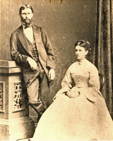 Federation University Historical Collection
Photograph, William Coghill Jnr and Catherine (Holmes) Coghill
William Coghill jnr of Coghill's Creek died in 1884 aged 63 and was buried at Ballarat. His wife Catherine Holmes was the daughter of Henry Holmes. She drowned in the 1866 wreck of the Ly-ee-Moon off Green Cape with the loss of 76 livesBlack and white studio photograph of a standing man and seated woman. They are William Coghill and his wife Catherine Dorothy Holmes, the descendants of Ballarat and District pioneer families. They married in 1860. Written in blue ballpoint pen verso: "Thought to be Wm Coghill Jnr and his wife (Miss Holmes). Wm Coghill buried Ballarat, died 1884, aged 63 years. His wife drowned in the wreck of Ly-ee-moon, a popular passenger ship, off Green Cape (near Eden, NSW) and...[drowned in 1866 with many others including her brother Edmund Holmes]. chatham, chatham family collection, william coghill, catherine holmes, catherine coghill, ly-ee-moon, coghills creek, coghill, holmes -
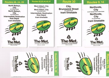 Melbourne Tram Museum
Ephemera - Timetable, The Met, Set of 7 Tram Timetables - The Met, 1986
Set of 7 Tram Timetables, Printed fold out timetable for various tram routes, published by The Met. Provides a map, description of route, time points, timetable, ticketing information (Travel cards and Neighbourhood tickets). .1 - Routes 9 and 14 - Northcote City both via Collins St and Latrobe St. - 13/4/1986 .2 - Route 30 - City - Brunswick St via Latrobe St - 24/3/1986. .3 - Routes 42, 23, 33, 45 and 47 - Mont Albert both via Collins St and Latrobe St. and Kew Depot - 12/2/1986 .4 - Routes 48, 24 and 29 North Balwyn both via Collins St and Latrobe St. and Kew Depot - 24/3/1986 .5 - Routes 70 and 76 - Wattle Park and Camberwell Depot - 24/3/1986. .6 - Route 76, 76 and 28 - East Burwood - City, Camberwell Depot and Richmond - 24/3/1986 .7 - Route 96, 97 and 95 - East Brunswick - 24/3/1986trams, tramways, timetables, tickets, tram services, route 9, route 14, latrobe st, la trobe st, kew depot, route 30, route 42, route 23, route 44, route 45, route 47, route 48, route 24, route 29, route 70, route 76, route 75, route 28, route 96, route 97, route 95, camberwell depot -
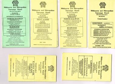 Melbourne Tram Museum
Ephemera - Timetable/s, Melbourne & Metropolitan Tramways Board (MMTB), "MMTB Tram Timetables", 1974
Set of 6 MMTB Tram timetables, folded sheets, generally 10 sections, providing timetables for specific routes, day of week giving information on tram times at specific time points, route map, sections and fares and organisation address - 616 Little Collins St. Melbourne. All printed on yellow paper unless noted otherwise. .1 - Route 48, 41, 40, 29, 74, 75, 76, 28 - North Balwyn and Burwood - City - Saturdays and Sundays - Feb. 1974, printed on green paper. .2 - Route 42, 23, 44, 45 and 37, Mont Albert - City - May 1974 .3 - Route 48, 41, 40, 29, 74, 75, 76, 28 - North Balwyn and Burwood - City - Feb. 1974 .4 -Route 59, 49, 52, 51, 81 - Essendon Airport - City - Oct. 1974 .5 - Route 70, 71 and 76 - Wattle Park - City - Feb. 1974 .6 - Route 72, 32 and 73 - Camberwell - City - Feb. 1974trams, tramways, mmtb, timetables, melbourne, fares, route 23, route 24, route 28, route 29, route 32, route 37, route 40, route 41, route 42, route 44, route 45, route 48, route 49, route 51, route 52, route 59, route 70, route 71, route 72, route 73, route 75, route 76, route 81 -
 Bacchus Marsh & District Historical Society
Map, Limestone Reserve Parish of Merrimu 1888
Limestone deposits in the Coimadai area 10 kilometers north of Ballarat were first worked in the 1850s. The area was quarried for limestone for many years by various people and companies. The surveyor's name who produced this plan is inscribed on the map and below this is the name P. L. Alkemade, who presumably paid for the map to be produced. In 1886 Petrus Alkemade in partnership with Matthew Egan established the Alkemade Hydraulic Lime and Cement Company. The Alkemade family were involved in the limestone industry over several generations at Coimadai.Single page map showing part of the Limestone reserve near Coimadai in the Parish of Merrimu. Scale 4 chains to 1 inch. Part of a set of maps which are pasted into a bound volume containing 76 maps or plans in total. High resolution digital image stored on BMDHS computer network. Copy of plan surveyed by Mr. G? [illegible] an authorised surveyor on 17th July 1888. P. L. Alkemadebacchus marsh victoria maps, lime kilns coimadai, limestone, coimadai victoria maps, alkemade family coimadai -
 Bacchus Marsh & District Historical Society
Map, Main Road and Gell Street Allotments
This map shows allotments of land along Gell Street Bacchus Marsh running between Main Road (now called Main Street) and Lerderderg Street. The total area of the map encompasses Main Road, Church Street, Lerderderg Street and Gell Street. 36 allotments of land are shown. Three allotments which connect to Main Road are shaded in pink. The date of the map has not been established but the National Bank building erected in 1865 near the Border Inn is indicated which indicates that the map dates from after 1865. Reports in the Bacchus Marsh Express newspaper on 5 March 1870, page 2, column 6 announced building lots in Gell Street had been withdrawn from sale by the agent J.E. Crook. Later reports in the Express on 1 November 1873, page 2, column 2 advertised 14 allotments of land in Gell Street for sale. Single page map showing allotments of land along the Main Road (Main Street) and Gell Street areas of Bacchus Marsh. Part of a set of maps which are pasted into a bound volume containing 76 maps or plans in total. High resolution digital image stored on BMDHS computer network. bacchus marsh victoria maps, gell street land allotments, main street land allotments -
 Melbourne Tram Museum
Photograph - VR 53 being transported to Bendigo, Rodney Hudson, Feb. 2006
Colour photo of Victorian Railways No. 53, later MMTB 53 and renumbered to VR 700 during 1975/76 on a L. Arthur semitrailer being transported to Bendigo for refurbishment. The tram was donated to the ARHS Museum in Newport in September 1980. The L. Arthur building is in the background. Yields information the history of VR 53.Full colour photo with Rodney Hudson and image number printed on the rear by the photo printer. Printed on Fuji papertramways, trams, vr class, vr trams, tram 53, l. arthur, transporting trams -
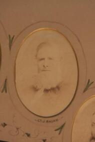 Learmonth and District Historical Society Inc.
Photo. Baird.J, Richards & Co.Photos Ballaarat, Councilor J.Baird, 1883-84
Councilor James Baird was first Elected to council in1863 until 1865 and again in 1868 until 1887.He was elected the first President of the Ballarat Shire in1863-64.He also served three further terms as President in1874-75,1875-76 and 1879-80 This Original photo forms part of a collection of photos of all councilors for the year 1883-84. The photo of Councilor James Baird, is in Sepia and oval in shape,set in a "light tan" mount with gold edging around cutout.Councilor J.Bairds' name is inscribed at base of photo.Around the photo is drawn a fine line with decorative features which connect it to the next.It is set at the top right of circle of photos of all councilors for 1883-84.PRESENTED by the PRESIDENT J.DALGLEISH ESQ.to the BALLAARAT SHIRE COUNCIL.1883-84.ballarat shire council, james baird, first shire president 1883 84 -
 Tennis Australia
Bicycle, Circa 1925
A Westfield 'Columbia' bicycle, featuring a tennis racquet holding clip at the rear of the bike frame. Bike features Torrington bicycle pedals, and U.S. Rubber bicycle tyres. Inscription across rear tyre: UNITED STATES No. 76 GIANT CHAIN TREAD. Materials: Metal, Chrome plate, Rubber, Paint, Clothtennis -
![Map, [Coornmill land area available for leasing for grazing, Parish of Coornmill]. Circa 1904](/media/collectors/5e461d8021ea67224c82f2a1/items/677cde147f2053f3e5d277c3/item-media/677cdeea7f2053f3e5d27bb4/item-fit-380x285.jpg) Bacchus Marsh & District Historical Society
Bacchus Marsh & District Historical SocietyMap, [Coornmill land area available for leasing for grazing, Parish of Coornmill]. Circa 1904
This map shows an area of land north of Bacchus Marsh in the Larderderg State Park area known as the Parish of Coornmill.The map indicates an area of land which was to be made available by public tender for grazing leaseholders. The plan to do this was discussed in the Bacchus Marsh Express newspaper on the 16 July, 1904, page 2, column 7. The area reserved for grazing leases is identified by red lines on the map. The Express described the area available for grazing was 12,000 acres.A single page paper map showing an area of land in the Parish of Corrnmill to be made available for grazing leases. A photo lithographed Lands Department Map. No scale indicated. The map is pasted into a bound volume containing 76 maps or plans in total. High resolution digital image stored on BMDHS computer network. coornmill parish maps, lerderderg state park maps, agriculture bacchus marsh area -
![Map, Plan showing proposed deviation of the road through McKenzie's Flat to Bacchus Marsh. [Undated]](/media/collectors/5e461d8021ea67224c82f2a1/items/677d22f37f2053f3e5d500dc/item-media/677d25247f2053f3e5d50950/item-fit-380x285.jpg) Bacchus Marsh & District Historical Society
Bacchus Marsh & District Historical SocietyMap, Plan showing proposed deviation of the road through McKenzie's Flat to Bacchus Marsh. [Undated]
The date of this map or plan is uncertain. McKenzie's Flat is a bushland picnic area on the Lerderderg River in the Lerderderg State Park close to Bacchus Marsh. The proposed road deviation shown on this map is very close to a sharp bend in the Lerderderg River which shows an island in the centre of that bend. The name of a landholder, J.B. Perry is shown on the map close to the area of the road deviation.The land shown is identified as within the Parish of Merrimu.Single page map showing a proposed deviation of the road from McKenzie's Flat to Bacchus Marsh. Scale: 5 chains to 1 inch. Part of a set of maps which are pasted into a bound volume containing 76 maps or plans in total. High resolution digital image stored on BMDHS computer network. mckenzies flat bacchus marsh, bacchus marsh roads and streets -
 Bacchus Marsh & District Historical Society
Map, Plan of Land at Bacchus Marsh, the Property of James Young, 1868
James Young was a prominent businessman, land owner and public figure in the early colonial period of Bacchus Marsh. In February 1868 he offered for sale through the agent W. Anderson 38 blocks of land which ran from the Lerderderg RIver westwards beyond Gisborne Road in the vicinity of the present day Masons Land. The land for sale was described as, 'unsurpassed Agricultural Land, in the immediate vicinity of Bacchus Marsh, varying in size from 2 to 12 acres each'. The sale notice in the Bacchus Marsh Express of 1st February 1868 page 2, also noted that, ' Plans can be seen at Mr. Young's Border Mills Store, and at the Border Inn'. One of the largest and most important land sales in the early colonial period of Bacchus Marsh.A single page paper map showing 38 blocks of land for sale in 1868 in the vicinity of Masons Lane Bacchus Marsh. Scale 11 chains to 1 inch. The map is pasted into a bound volume containing 76 maps or plans in total. High resolution digital image stored on BMDHS computer network. land sales bacchus marsh, bacchus marsh victoria maps, james young 1816-1871, masons lane bacchus marsh land sales -
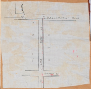 Bacchus Marsh & District Historical Society
Map, Lord Street, Bacchus Marsh. Undated
A small single page map showing the line of Lord Street Bacchus Marsh between Ballarat Road (Main Street) and Simpson Street. Part of a set of maps which are pasted into a bound volume containing 76 maps or plans in total. High resolution digital image stored on BMDHS computer network. bacchus marsh victoria maps, lord street bacchus marsh maps -
Surrey Hills Historical Society Collection
Work on paper - Vertical file, Canterbury Football Club
1. ‘Football champions’, (U/12 team; includes a photo), SHNN No 24, Oct/Nov 1986 2. ‘Local super league rumours’, SHNN No. 76, June/July, 1995 (1 page). 3. Auskick Season 2023 (includes 3 photos), SHNN No 245, Aug/Sept 2023 -
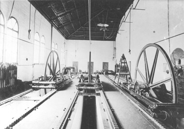 Melbourne Tram Museum
Photograph - Cable Engine house interior - Gertrude St
Photo of the interior of an engine house showing the tension wheels for three different cables. See page 76 of Mind The Curve by Keating, showing the cable tensioning arrangements. Based on a review of the window arrangements, it is believed to be the Nicholson St and Gertrude St winding house. See attached email.Yields information about the interior of a engine house powering three separate cables.Black and white print with a plain backtrams, tramways, cable trams, engine houses, power house, winding house, gertrude st