Showing 458 items matching "apples"
-
 Whitehorse Historical Society Inc.
Letter - Correspondence, The Fruitgrowers and Primary Producers Defence League of Australia, 1946
To WG Payne from Reporter Pty Ltd1 4.1946To WG Payne from Reporter Pty Ltd account rendered 2 6.1946Ditto 3 4.1946To WG Payne from G Compton re inconvenience to growers in stands ôKö & ôLö 4 6.1946To WG Payne from HJ Noonan re registration of citrus growers & limit planting 5n.some activities of District Council since last year 6 4.1946To WG Payne from JM Ward re Mr GayfordÆs lecture on pest control measures 7 7.1946To WG Payne from HJ Noonan re notice of AGM 8 4.1946To WG Payne from G Handsyde re meeting concerning citrus growers organizations 9 5.1946To WG Payne from GW Gayford re a suitable date for his lecture 10 6.1946To WG Payne from G Handsyde re an official representation at meeting 11 5.1946To WG Payne from G Handsyde re lecture by Mr Gayford 12 3.1946To WG Payne from G Compton re congestion in sheds ôKö & ôLö 13 3.1946To WG Payne from W McKenzie re registration & licensing of growers 1410.1945To WG Payne from GW Gayford re DDT spray substitute for nicotine-sulphate 1510.1945To RS Ryan from FM Forde re concern of importation of apples from America 16n.d.To M&MDC;DL from W Payne re action of Inspectors condemning bushel cases 1710.1945To WG Payne from JM Ward re neglected orchards due to shortage of labour 1810.1945To MMDC F&PP Defence League from HC Pope re production of Secateurs 1910.1945To WG Payne from JM Ward re transferring of Orchard Supervisors 20 2.1945T0 WG Payne from HJ Noonan re copy of Conference report. To WG Payne from Reporter Pty Ltd clubs and associations, fruitgrowers and primary producers defence league of australia -
 University of Melbourne, Burnley Campus Archives
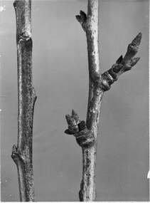
Photograph - Black and white photographs, James (Jim) Pleasance, Pruning Display
Black and white photographs of various sizes pasted on cardboard for display purposes. Some annotated. (1) (2) Difference between leaf and fruit buds. (3) "The 'rod' or whip is most suitable plant to commence training." (4) Planted and pruned fruit tree. "School of Horticulture and Primary Agriculture Burnley B. 1 " stamped on reverse. (5) "Pear Tree-Unpruned (1) June." (6) "Same Pear Tree-Pruned (2) June." (7) Young unpruned "William bon Chretien". Reverse, Burnley Stamp. (8) Same tree pruned. Reverse, Burnley Stamp. (9) Unpruned pear tree. (10) "Narrabben" plum before inserting branch spreaders. (11) With branch spreaders. (12) Close up of some of its branches without spreaders. (13) Close up of branch with seaders. (14) Plum tree with spreaders. (16) Close up of fruiting spurs. (17) "Apple Blossom Oct. Reverse, p 163(Oct." )(18) Same photograph enlarged. (20) Close up of fruiting buds. (21) Old unpruned apricot tree. (22) "Unpruned branch of apricot tree." (23) Close up of apricot branch. (24) "Same branch-apricot-pruned June Reverse, p99 (June)."(25) Pruned branch stump of mature fruit tree.(26) "Clean saw cuts with sharp knife." (27) "Treat all large wounds on trees to avoid infection by wood rotting fungus." (28) "Apply coating of lead paint or grafting mastic." (29) "Branch of lemon-unpruned Aug. Reverse, p157 (Sept.)." (30) "Same branch of lemon-pruned Aug. Reverse, p 157 Aug."(31) "Young climbing rose-ready for planting-July." (32, 33) Grape vine before pruning. (34) Same vine pruned and trained. (35) Older vine pruned.fruit bud, rod, whip, school of horticulture and primary agriculture, burnley, pear tree, spreaders, plum tree, apricot tree, fungus, lead paint, lemon, roses, grape vine, leaf bud, training, fruiting spurs, apple blossom, grafting mastic, teaching, a w jessep -
 Kiewa Valley Historical Society
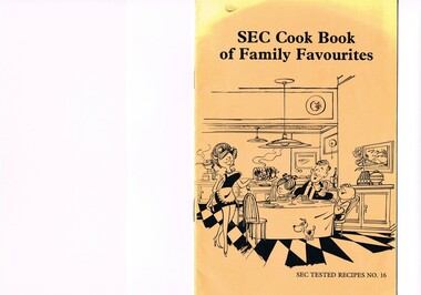
Book - Reference Cooking, SEC Cook Book of Family Favourites, Circa 1950
This SEC cook book was produced circa 1950s when the Kiewa Hydro Electricity Scheme and its Commission was in full swing. The Commission had constructed two settlements, Mount Beauty and Bogong Village to house construction workers and their families in a "closed" community. These "closed" communities were for SEC staff and construction workers only. Entry into these villages was restricted to "SEC pass" carrying construction staff and their families. All facilities such as retail, sporting and other community services was provided by the SEC. This created an isolated community in which limited individual choice or administrative family leeway was available. It was a typical company town (live and work for the company). The Company was in the Kiewa Valley constructing power stations for the Kiewa Hydro Electricity Scheme of Victoria. In one way the individual did not need to be concerned with living costs, educational needs for children, and recreational amenities and therefore "normal" community survival /living methods did not apply. This living, although restrictive, was quite simple. When the scheme was completed, in 1961, marking the end of company town, caused some of the employees, who had enjoyed the "controlled" township environment, a fair degree of angst in having the new 'laissez-faire" controls thrust upon them. This was magnified when both Mount Beauty and Bogong Village became meshed into the Bright Shire, vis-a-vis, local government. This cook book is a prime example of " the company is looking after you" and leave the worrying to us. This environment of a "company town", which creates the atmosphere of minimal personal responsibilities, is still present in a few remote mining towns in Australia at the beginning of the 21st Century.This book is a classical example of the psychological control in which the company had its construction workers families living in. The motto of many companies who had employees in isolated regions was "keep them happy". A happy and contented worker is a more productive worker. This was a period in time (1950s to 1970s) when social psychology was gaining recognition in the Australian workforce as well as internationally. At the end of the construction of all the power stations both the Mount Beauty settlement and the Bogong Village became more integrated into the main stream of rural Australia environment. Development of tourism in the region opened up not only interaction with a greater cross section of the ever expanding type of Australian but also the overseas based non rural culture tourist or immigrant. It allowed the intermingling of ideas in a non company controlled environment. The Mount Beauty and Bogong Village has, and even up to the 3000 Millennium, the same housing construction, as was built by the SEC. There has only been a very gradual change to modern domestic architectural home styles. This SEC cookbook has a folded cover with two staples at the spine, securing eight double sided pages. The white pages contain black print and sketches(3), and one black and white photograph (of the author). The front cover is mainly orange in colour with a gradual fading into yellow(at the top). The cover is approximately 210 g/m2 in thickness and each page is approximately 90 g/m2 thick. Front cover: top of page "SEC Cook Book of Family Favourites", in the middle a sketch, black on orange background, of a smiling mother walking from the kitchen to the dining table with a steaming rolled roast and vegetables in one hand and a gravy pot in the other. The furniture and decor relates to the 1950s. Below this sketch is printed"SEC TESTED RECIPES NO. 16" Inside cover: on top of the page is a black and white sketch of a pineapple, apple pear fish with scales, bunch of grapes with leaves a pork roll (head of pig one end and a roll ending on the other, on top of this food arrangement rests a fruit pie. Below this sketch are printed in black print the books contents.The first side of the first page is a black and white photograph Mary Dunne, the SEC Home Service supervisor who provided a signed foreword. The inside back cover has a promotional segment detailing a black and white photograph of a smiling (and happy) couple in the foreground with an electric stove in the distance. The written motto below this photograph is" to Live better -and save money they'll join the Power People. "the new tariff is(1960s) - First 75kWh --6 cents per kWh Next 435 kWh---2.3 cents per kWh Balance --1.7 cents per kWh The rate per killowatt-hour for the final block drops from 2.1 cents to 1.7 cents --a reduction of 19%.cooking recipes circa 1950s, domestic food, sec victoria cook books, recipes circa 1950s -
 Eltham District Historical Society Inc
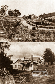
Negative - Photograph, Albert Jones, 'Golden Glen' at Wattle Glen and the Wattle Glen General Store, c.1910
Top photo: The property 'Golden Glen', home of photographer, Albert Jones. At the right of the photo is an apple orchard over the other side of Watery Gully creek. The middle building in the photo is still standing, located on Wattle Glen - Kangaroo Ground Road between Pretty Hill Lane and Millers Road (Melway 271 A6) but on the opposite side of the road. Bottom photo: The Wattle Glen General Store in this photo was located at the same intersection as the present Wattle Glen General Store (cnr of Reynolds Road and Kangaroo Ground Road) but on the diagonally opposite corner. [Comment from Valda via Victorian Collections June 11, 2018] "The addition to the store on the left, and the building at the back, were not part of the store/post office owned by the Keenan's. They were added by Mr and Mrs Alan (Janet) Frencham's in the ?mid-1950s." See also EDHS_03112: See Ref: EDHS_03112 A WINDOW ON THE PAST by Roger Sanders, The Sun, Wednesday, Auguist 11, 1976, pp 38-39 A fascinating window has been opened on the early life of the Eltham district. It is a rare collection of 3,000 perfectly preserved glass plate photograph negatives. The collection is the work of the late Albert Jones, a Diamond Creek orchardist and amateur photographer. About 500 of the negatives have been printed and 100 are on display at Gallery 4, Eltham, as part of the Eltham Festival," which started on Friday. They capture in fine detail rural and village life around Eltham, Hurstbridge, Kangaroo Ground, Yarra Glen and Diamond Valley from 1900 to 1930. While the natural beauty of the district was painted in this period by Arthur Streeton (later Sir Arthur), Tom Roberts and Charles Conder, among others, photography was relatively new. Yet Albert Jones used the new medium to compile a weighty album of pioneers at work, at home, at sport and on holidays. He was at the first Yarra Glen race meeting, early Diamond Valley football matches and photographed soldiers from the district leaving for war. He photographed early gold mines, men with horses laying the Diamond Creek-Hurstbridge rail track and the arrival of the first steam train at Hurstbridge. He took his cameras on holiday around Victoria and the collection includes scenes from St. Kilda and Portsea and many country towns. The Jones collection of negatives was found by Mr A. J. "Ned" Spark, of Balwyn, under a house he bought from Mr Jones' widow. The plates almost went to the tip with a pile of rubbish before Mr Spark realised their potential value. Mr Spark, who is retired, will continue the identification and recording of the photographs when he returns from holidays. The exhibition of the Jones' photographs is open each afternoon until August 21 at Gallery 4, 1016 Main Rd., Eltham. Photographs included in article: • The priceless collection of glass plate negatives were found under this house in Eltham [actually Wattle Glen], home of Albert Jones and his wife. • A quiet country pub - Panton Hills Hotel. • Teams of draught horses were used in the building of the Diamond Creek-Hursbridge railway in 1910. • Chinaman Jimmy using a gold cradle in Wattle Glen Gully. • The photographer and orchardist Albert Jones. His work is on show as part of the Eltham Festival • St Kilda Pier – several of the houses are still standing, but the waterfront has changed dramatically since this was taken before 1920. • A picnic was a dressy affair at the start of the century – the women in this family group are decked in lace and pearls.Roll of 35mm colour negative film, 4 stripsKodak Safety 5035albert jones, golden glen, shops, wattle glen -
 Eltham District Historical Society Inc
Photograph - Digital Photograph, Alan King, Panton Hill Hotel, 27 March 2008
Today’s Panton Hill Hotel was built around 1920. Published: Nillumbik Now and Then / Marguerite Marshall 2008; photographs Alan King with Marguerite Marshall.; p61 Panton Hill was originally known as Kingstown, and consisted of only one hotel when the Orams Reef was discovered in 1859. Kingstown was a quartz mining centre and many old mine shafts remain in the area. Orams Reef was one of the first reefs with a rich find of gold in the area. The Hotel Francais, which had been operating in 1861, was well situated on the way to Queenstown (later St Andrews). So was Herr Hirt’s Hotel and store at Smiths Gully. The Kingstown hotel, known as the Frenchman’s and in 1864 as the Hotel de France, was run by a Monsieur Emile Hude and his wife Jeanne, and known for its good food. They hosted social events, business conventions and debates, attracting patrons from as far as Melbourne. The hotel’s name was changed to Panton Hill Hotel in 1905. In 1883 Charles Caudwell built another hotel nearby, possibly in Long Gully Road,3 which it is thought, was burnt down early last century. Today’s Panton Hill Hotel, built around 1920, is the only one of the cluster of buildings in the main road, not to date from around the turn of last century. It was severely damaged by fire in 2003, then underwent extensive alterations. It is the township’s only hotel and is an example of a modest hotel building exterior, constructed early last century. In its early days the hotel also housed the first post office, newsagency and store. Orams Reef yielded a total of £100,000, and fossikers also found alluvial gold in the creeks and gullies, but there is no record of the total value of their finds. Gold greatly increased the Panton Hill population, which peaked between 1865 and 1885. On holidays large sports meetings were held with wood chopping contests and foot races and the day would end with a ball. Miners came from various countries to seek their fortune, including many from China. The Chinese became unpopular however, and gradually left the district, although some stayed and grew and sold vegetables.5 Panton Hill was named after Joseph Panton, who in 1862 was appointed Police Magistrate for the Woods Point, Heidelberg and Yarra districts. Panton was an outstanding man, who in 1852, was Commissioner of Crown Lands and Assistant Commissioner of Goldfields at Bendigo. In 1874 he was promoted to Chief Magistrate for the Melbourne Police. Panton was also an artist, becoming president of the Victorian Arts Society in 1888, and in 1913, president of the Royal Geographical Society. Despite Panton Hill’s prosperity, it still lacked many services as poor roads made access to Melbourne difficult. A horse-drawn mail coach travelled to Melbourne until 1890, when the railway came to Heidelberg. The nearest doctor was at Yarra Glen or Heidelberg, and the Indian hawker Singh’s annual visit was very welcome. A miner’s shack opposite the school was used as a post office. Today’s general store and post office in the main road dates from early last century, and has changed considerably. While most people searched for gold, the more enterprising ones established farms to feed the diggers. Farmers grew wheat, barley and oats, and sent animal skins to the Eltham tannery, to make furs in Melbourne. As gold became scarce from around 1880, miners took up farming on 19 to 20 acre (8ha) allotments. The first settlers in Cherry Tree Road included Purcell, Smith, Owens, Hughes and Shillinglaw. By 1900 all the land had been taken up around Panton Hill and Hurstbridge. The orchards in Panton Hill and the wider district, particularly of apple and pear, were very successful, and made Panton Hill a cohesive and successful community. About 1914 the Moores built the first cool-store and refrigeration plant at their orchard in Cherry Tree Road. Many settlers planted vineyards and made high quality wine, but in 1922 the blight destroyed them.This collection of almost 130 photos about places and people within the Shire of Nillumbik, an urban and rural municipality in Melbourne's north, contributes to an understanding of the history of the Shire. Published in 2008 immediately prior to the Black Saturday bushfires of February 7, 2009, it documents sites that were impacted, and in some cases destroyed by the fires. It includes photographs taken especially for the publication, creating a unique time capsule representing the Shire in the early 21st century. It remains the most recent comprehenesive publication devoted to the Shire's history connecting local residents to the past. nillumbik now and then (marshall-king) collection, panton hill hotel -
 Puffing Billy Railway
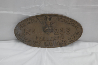
Phoenix Foundry Plate
Phoenix Foundry Plate - replica Made about 2010 cast off original from locomotive Y112 The Phoenix Foundry (1857-1906) fabricated iron and brass products - including engines and pumping gear for the mining industry, locomotives, steam rollers, water pipes, water gauges and diverse small items. Throughout its operation the business was located at premises on Armstrong Street, Ballarat . Background In 1852, at the age of thirty-three and after a year of operating his own engineering business at Williamstown, Lancashire-born blacksmith and engineer George Threlfall (1819-1897) arrived on the Sebastopol gold plain and immediately undertook blacksmith work repairing picks and tools for the miners. Little did he know that this fledgling business would be the genesis of the most iconic business of nineteenth-century Ballarat. At approximately thirty-nine years of age, English mechanical engineer Richard Carter (c1814-1883) came to Australia on board the Arrogant - arriving in Melbourne on 19 April 1853. He soon travelled to the Ballarat goldfields. Born in the year 1830 in Belfast (Ireland), mechanical engineer William Henry Shaw (1830-1896) arrived in Australia in October 1853. He worked briefly with George Threlfall at Sebastopol, then moved to Geelong to manage the small foundry of Frederick Moore. Twenty-four year old English-born iron moulder Robert Holden (c1831-?) left his home in Belfast (Ireland) in late 1854 and travelled from Liverpool to Melbourne on board the James Baines - arriving in February 1855. Afterwards he joined his brother-in-law William Henry Shaw in Ballarat. History Foundation to Incorporation In March 1857 George Threlfall joined in business with Richard Carter, William Henry Shaw and Robert Holden. They relocated Threlfall's successful engineering enterprise from Sebastopol to new premises in Armstrong Street, Ballarat. This business was then known variously as the Phoenix Iron Works Company, Phoenix Foundry or Messrs Carter and Co. By 15 April 1857 they were advertising that they were open for business as engineers, millwrights, boiler makers, smiths, iron founders and brass founders. In January 1858 George Threlfall left the partnership. Incorporation to 1889 1890 to Closing locomotive Y112 Builder: Phoenix Foundry, Ballarat Builder’s Number & Year: 238 of 1889 Designer: Kitson & Co Wheel Arrangement: 0-6-0 No. in class: 31 Entered Service: 24 July 1889 Taken off Register: 11 May 1961 The origins of the Victorian Railways Y-class lay with the decision by Kitson & Co, Leeds to place a 0-6-0 freight locomotive on display at the Centennial International Exhibition, Melbourne in 1888, together with a 2-4-2T suburban passenger locomotive. This marketing initiative proved successful as the Victorian Railways were clearly impressed with these machines, with both purchased after the exhibition and becoming the patterns for new standard locomotive types. Thirty examples of the 0-6-0 heavy freight design were ordered from the Phoenix Foundry, Ballarat, becoming the Y-class for main line heavy freight duties, while the 2-4-2T design became the E-class for Melbourne suburban passenger duties (represented by preserved locomotive E 236). The Y-class prove successful in service and accrued high mileages. They were inevitably superseded by more modern and powerful steam locomotives and a number cascaded into shunting and yard pilot duties, often with the addition of shunters steps along both locomotive and tender. Y 112 was one of the last in service when withdrawn in 1961. Fortunately it was saved for preservation and plinthed in central Ballarat, ostensibly in commemoration of Phoenix Foundry. I understand it is owned by the Sovereign Hill Museums Association. During the 1980’s, Y 112 was leased to Steamrail Victoria and restored to operation at an industrial site in Ballarat. Y 112 features an attractive lined apple green livery and has performed various rail tours around Victoria since restoration. It is normally based at the Steamrail depot in Ballarat East. Y 112 is the only 19th century design in operational condition in Victoria and as such is one of the oldest working steam locomotive in Victoria . Historic - Phoenix Foundry Plate - replica Made about 2010 cast off original from locomotive Y112Phoenix Foundry Plate Oval shaped plate with an image of a phoenix centered at the top with lettering surrounding it.Phoenix Foundry No 238 Ballarat Company Limited 1889.puffing billy, phoenix foundry, ballarat, locomotive y112, phoenix foundry plate - replica -
 Eltham District Historical Society Inc
Film - Video (DVD), Frank Stokes, Stokes Family, 1950-1977
Various family scenes taken from outside the family home on the southeast corner of the intersection of Nyora Road and Pitt Street with Eucalyptus Road. Also, scenes of the Stokes Orchard and equipment used, construction of water reservoir at the end of Nyora Road near Reynolds Road and Diosma Road as well as early stages of the Stokes Orchard housing development. Frank Stokes worked as a qualified accountant at Kennons leather factory in Burnley, while living at 1 Thomas Street, Mitcham. He suffered from migraines and wanted to go back to the land (he had previously worked on farms and orchards since coming to Australia in 1926 both in WA and Vic.). He first travelled to the district by train in July 1942 to find land with the intention to establish an orchard. By chance he met Arthur Bird of Bird Orchard (bounded by Pitt Street, Eucalyptus Road and Wattle Grove) and they got talking over their common interest. Arthur put Frank up for the night and pointed out the land, 158 acres- Taylor Estate- £900, part of Crown Allotment 15, Section 5, Parish of Nillumbik (CA15) somewhat diagonally opposite Bird Orchard. He applied through the Riverina Agency to purchase the land who in turn had to get permission from Canberra to sell as there was a new government regulation banning land sales except for immediate production. He obtained a loan on his Mitcham house of £600 @ 5% and paid £450 deposit with quarterly payments of £15 over 5 years. The title to the property was issued May 15, 1946. He was helped and advised by Arthur Bird who farmed the neighbouring orchard. Early 1943 he took possession and would catch the train out to Eltham on Fridays after work and began building a hut for shelter and to lock up tools. He was able to pay a neighbour (Hawkins) to help with clearing and fencing 25 acres and with a horse and single furrowed plow, planted approximately 2,500 fruit trees - cherries, peaches, plums, almonds, pears, apricots and lemons as well as a few apples and oranges; a massive job. A huge problem was hares and rabbits eating all the new buds off the tiny trees. As well as laying poison he painted the trees with a mixture of cow manure and lime. Often working by moonlight. It was extremely difficult to get wire and wire netting because of the war but after much effort he obtained a permit from the Agricultural Department for supplies in March 1944. In February 1945 he applied for a permit to build a “packing shed” as no house building allowed. It was to be 33 feet x 21 feet and cost £312. Constructed mostly from second-hand materials, which was hard to obtain, especially iron for roofing. Frank finished work at Kennons October 31, 1945, and in March 1946 he sold the Mitcham house for £1230 plus £170 for furniture. The family of five then moved into a very unfinished at Eltham, which was a struggle to weatherproof. Eventually rooms were divided off and lined with hessian bags and whitewashed. Their income was firewood (cut and sold), selling rockery stones and cut sweet bursaria. (It was discovered during the 1940s that Bursaria contained the sunscreen compound Aesculin. The RAAF utilised this compound from Bursaria during WW2 for pilots and gunners.) The orchard’s first fruit sale was a 1/2 case of Le Vanq peaches in December 1947 - 8 shillings. In 1956 plans for house were drawn and Glen Iris bricks purchased (1956 Olympic Rings variant). The building of the house commenced in 1957 - 12 feet of original packing shed removed – and was completed in 1959. Water was connected from newly built pressure storage on the property at the end of 1959 and the electricity connection for the first time at 3pm on April 29, 1960. In the mid-1970s the Shire of Eltham divided the orchard up into numerous rate-able parcel lots, which became unaffordable for Frank. Consequently, Stokes Orchard was turned into a housing development by Macquarie Builders and marketed as the Stokes Orchard Estate in two stages; Stage 1 encompassing Scarlet Ash Court, Ironbark Close and Peppermint Grove bounded by Nyora and Eucalyptus roads c.1976 and Stage 2 encompassing Stokes Place, Orchard Way, The Crest and The Lookout bound by Nyora and Diosma roads c.1979. The development of Orchard Way, The Crest and The Lookout did not proceed as planned due to the lack of the sewer along Diosma Road and so many of the proposed lots were incorporated into five-acre parcels instead. With the arrival of the sewer along Diosma Road many years later, most of these five-acre parcels have since been subdivided many times.Representative of the orchard growing areas of ElthamMP4 00:24:39; 426MB Digital file only - Digitised by EDHS from a DVD copy on loan from Beryl Bradbury (nee Stokes), daughter of Frank Stokes. 24 min duration compilation of home movie Super 8mm film shot by Frank Stokes brother-in-law.beryl bradbury (nee stokes) collection, frank stokes, nyora road, stokes orchard, stokes orchard estate, stokes place, video recording -
 Kew Historical Society Inc
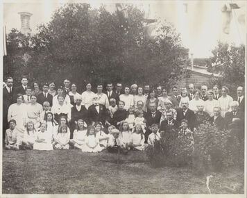
Photograph, James Venn Morgan's 100th Birthday, 1923
1823-1923.MR. JAMES VENN MORGAN. "FATHER OF" KEW."In a Village in Somersetshire in England on February 21, 1823, a son was born to George and Sarah Morgan. The child was so delicate that his parents feared that he would not live. How little ground the parents parents had for their fears may be judged from the fact that the boy, christened James Venn Morgan is still alive and hale. He is able to exhibit with pride the paper with its faded ink on which a clergyman wrote the certificate of his baptism almost 100 years ago. But for some slight infirmities of sight and hearing, Mr. Morgan, who is within six weeks of completing the 100th year of his life, is in good health, and is well able to attend to his business affairs. His immediate cause for regret is that he is not now able to do a day's work in his garden, as he was 12 months ago. After spending his early life in England, where he learned his trade as shoemaker, Mr Morgan came to Australia in April, 1851. He carried letters of introduction to Mr. Tripp, a solicitor, of Melbourne, who strongly recommended him to begin business as a shoemaker, and accordingly he opened a shop at the corner of Swanston and Bourke streets, where the Leviathan Stores now stand, and was not long in working up a good connection. Among his customers at that time Mr. Morgan recalls Mr. Justice A'Beckett and many leading men in law and medicine of the day. Then the news was flashed through Melbourne of the discovery of gold at Ballarat. Nothing can give a clearer idea of the excitement this news caused in Melbourne than that Mr. Morgan, who was a member of one of the first parties to leave for the diggings, left uncompleted in his workshop one of a pair of riding boots he was making for Mr. J. B. Weir. As the purchase of suitable clothing would have taken time, he set out to make his fortune wearing a top hat. At Ballarat he stayed for five or six weeks, and returned to Melbourne with 10oz. of gold. He remained in the city long enough to finish the second of the two riding boots, and then, with three companions, set out for Chewton, near Castlemaine. Here fortune smiled. The party tried their luck in an abandoned shaft, and in two weeks returned to Melbourne again after having won 35lb. weight of gold. How Kew Was Born. Mr Morgan was content with his success, and induced his partners to invest their money with him in land. After obtaining the advice of a friend, the party negotiated with Mr Samuel Watts, of Collngwood, who had recently purchased land from the Crown, and from him they took over at £15 an acre about 32 acres of land in the district that is now known as Kew. This land extended from where the Kew Post-office now stands to the locality of the Boroondara Cemetery. At that time there was not a house in the district, and there was a fairly large population of aborigines, but no white men. Here it was that Mr Morgan decided to settle, and, after having had the land surveyed, the partners apportioned it by drawing straws for the four sections into which it had been divided. One of them sold his holding later in the year for £100 an acre, and was sorry for it afterwards. In 1853 Mr. Morgan built the first house in Kew, and this house is the one in which he still resides. Here with his wife, he settled down to market gardening and dairying. He tells with a laugh how he was paid 1/ a lb for the first potatoes he grew, and 1/ a quart for milk. So successful was the new venture that he induced his father and other members of the family to come out to Australia to assist him. How different Kew of those days was from the Kew of to-day will be understood from Mr. Morgan's statement that for weeks at a time they never saw a a white face other than those of the family. The blacks, he says, although very noisy, were entirely friendly. Gradually the district became settled, Mr. Morgan parted with a portion of his holding, and subdivided and built on the remainder which he still retains. In 1884 he found himself in a position to retire from active business. Youth in Old Age. In Mr Morgan's garden, which is a large, one trees which he and his father planted more than 60 years ago are still bearing heavy crops of apples. Mr. Morgan has been a widower since 1915. He has three daughters all of whom are married, and numerous grandchildren and great-grandchildren. One of the great-grand children reccntly informed Mr. Morgan that he was about to be married. Perhaps the most striking characteristic of Mr. Morgan to-day is his activity. Not only does he move about with surprising alacrity, but is able to go into the streets and attend to his business affairs with but little fatigue The Argus, 17 January 1923, p.12.This work forms part of the collection assembled by the historian Dorothy Rogers, that was donated to the Kew Historical Society by her son John Rogers in 2015. The manuscripts, photographs, maps, and documents were sourced by her from both family and local collections or produced as references for her print publications. Many were directly used by Rogers in writing ‘Lovely Old Homes of Kew’ (1961) and 'A History of Kew' (1973), or the numerous articles on local history that she produced for suburban newspapers. Most of the photographs in the collection include detailed annotations in her hand. The Rogers Collection provides a comprehensive insight into the working habits of a historian in the 1960s and 1970s. Together it forms the largest privately-donated collection within the archives of the Kew Historical Society.A group portrait on the occasion of the 100th birthday of James Venn Morgan in 1923. Dorothy Rogers used this photograph in 'A History of Kew' (1973). It faces page 17. In the book, the caption reads "JAMES VENN MORGAN'S 100TH BIRTHDAY ANNIVERSARY. The party was held at 'Morganville'. Mr Morgan is shown with a group of descendants."James Morgans 100th Birthday Party. james venn morgan, kew, model dairy, dorothy rogers -
 Flagstaff Hill Maritime Museum and Village
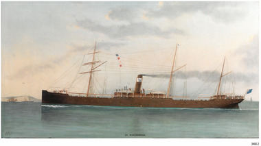
Photograph - Vessel, Sail and Steam Ship, S.S. Warrnambool
This photograph and a matching earlier photograph are the images of a painting of the British steamship SS Warrnambool at Dover Strait in the English Channel. The photographs were donated by the painting’s owner, who acquired the 30” x 56” (76 x 142.5 cm) oil on canvas painting in 1998. Both photographs were accompanied by a letter, one written in 2001, and the other in 2003. The letters confirm that the artist of the painting was Charles Keith Miller, signed with the initials “CKM” and dated “1893”. The painting shown in the photographs was a gift to the Town Council of Warrnambool, presented to Warrnambool folks in Melbourne on December 1, 1892, by the Captain of William Lund’s ship SS Warrnambool. The painting was given by Lund in appreciation of the Ladies of Warrnambool who had presented the ship with a ‘house’ flag bearing the Blue Anchor Line’s symbol of a diagonal blue anchor on a white background; the ladies had made the decision to present the flag only a month earlier. A few days later, December 6th, the SS Warrnambool was on its homeward journey to Britain, sailing via Adelaide. It anchored for a short time off the Port of Warrnambool. A boat was launched from Lady Bay to take a group of friends to the ship with a delivery of gifts. After cheers were roused for both the ship and the Captain, the ship continued on its way. The photograph shows the gifted white flag with a diagonal blue anchor flying from the masthead. The same symbol is painted on the ship’s black funnel. The signal flags on the foremast display ‘M’ ‘R’ ‘V’ ‘B’. These letters are most likely the ship’s call number ‘MRVB’. Although the painting was given as a gift in December 1892, it is post-dated “1893”. Perhaps the painting was given earlier than anticipated; or the date added later, but whatever the reason, the provenance of the painting was confirmed at auctions of this painting and other works by the same artist. CHARLES KEITH MILLER 1836-1907:- Captain Charles Miller left his home in Scotland at the age of 15 years for a life at sea. He earned his Master’s Certificate ten years later. After being the captain of sailing ships he moved over to the steamships because they were faster. In 1866 he married and settled in Glasgow. Over the following eleven years he and his wife had five children, then sadly his wife passed away. Captain Miller returned to the sea for a while but in 1888 he gave up his sea life to spend his time as a marine artist. His understanding of seafaring life and vessels, combined with his artistic skills, gave him the ability to produce fine art and several galleries and museums have collections of his sought-after works. S.S. WARRNAMBOOL 1892-1925:- The steamship SS Warrnambool was built in 1892 by the Sunderland Ship Building Company for the Lund Line of London, founded by William Lund in 1869. It efficiently carried both passengers and cargo across the world to Australia, under the command of her master Captain Joshua Edward Iibery, who had many years of experience with the Blue Anchor Line. The company, referred to as the Blue Anchor Line or BAL, owned a fleet of both sail and steamships. The funnels of all of the steamships were painted black, with a white band around the top bearing a diagonal blue anchor and chain. The company’s house flag was also white with a diagonal blue anchor. The SS Warrnambool carried passengers and cargo in a ‘no frills’ service to and from Europe around the Cape of Good Hope, stopping at some ports in between. The ship was involved in bringing home returned solders in 1895. At one time it carried a doctor from Victoria, Australia, to assist at the war front in South Africa. The ship had a very good reputation for its cargo arriving ‘almost always in excellent condition.’ Exported goods from Australia included iron safes, flour, wool, apples, frozen rabbits, butter, cheese, pork, cattle, poultry and sheep. One remarkable delivery contained Ostriches for Queen Victoria and they survived the journey well. The SS Warrnambool was sold in 1900 to the British and South American Steam Navigation Co. Ltd of Liverpool and was renamed ‘Harmodius’. The company was managed by R.P. Houston & Company of London and its Houston Line funnels were red with a black top. The Harmodius was sold in 1919 to K.S.S. Co. Ltd, managed by Kaye Son & Co. Ltd. of Liverpool, and was renamed ‘Kut’. The line had black funnels with a white ‘K’ in a diamond or between white stripes. In 1926 it was purchased by T.W. Ward Ltd. and broken up. NOTE- other vessels named “Warrnambool” Two other vessels carried the name “Warrnambool” (1)- HMAS Warrnambool J202 (1941-1947), a Bathurst Class corvette vessel owned by the Royal Australian Navy, destroyed by a mine. The photograph is significant for its association with the painting "SS Warrnambool" by well-known early 20th century marine artist Charles Keith Miller, whose paintings are well valued. The painting and the photograph of it are namesakes of Warrnambool and are connected through the gifts exchanged between the ship company owner, the City of Warrnambool and the Ladies of Warrnambool; the House Flag and the painting by C K Miller. The image is a good likeness to original photographs of the late-19th to early-20th century steam and sale vessel. Coloured photograph of a painting, the steamship S.S. Warrnambool. The three-masted ship has lowered sails. It is in calm water, land on one side, and other vessels in the water. The ship has four raised signal flags, a house flag and a blue ensign. The funnel also bears the house flags symbol. Smoke emits from the funnel. Figures are visible onboard. There is a signature and a title on the lower edge of the photograph. (Artist of the painting in the photograph was Charles Keith Miller)House flag symbol, [diagonal blue anchor on white background] Text "CKM" and "1893" Text "S. S. WARRNAMBOOL."flagstaff hill, warrnambool, photograph, steam ship warrnambool, flagstaff hill maritime village, shipwreck coast, ss warrnambool, captain, charles keith miller, ckm, 1893, william lund, warrnambool town council, blue anchor line, lund line, ladies of warrnambool, house flag, diagonal blue anchor, captain miller, sunderland ship building company, migrant ship, 1892 ship, home flag, bal, australian export, s.s.warrnambool, dover strait, english chanel, port of warrnambool, lady bay, mrvb, captain charles miller, captain joshua edward iibery, ostriches, queen victoria, british and south american steam navigation co., harmodius, r.p. houston & company, houston line, k.s.s. co. ltd, kaye son & co. ltd, kut, t.w. ward ltd -
 Eltham District Historical Society Inc
Book, Percy Leason: an artist's life by Margot Tasca, 2016
"Who would have thought that a boy born in 1889 from the Victorian Mallee would become a successful artist on New York’s Staten Island? This finely illustrated, exhaustively researched and beautifully written biography on Leason features the artist’s entire career as a painter and cartoonist renowned for his depictions of Australian society in the 1920s and 1930s. Leason’s story is a poignant one tracing his beginnings as a cartoonist, to the bohemian Melbourne art scene in the early 20th century, to his involvement in the artists’ camps of Eltham, to his important series of portraits of Lake Tyers Indigenous Australians, and his eventual move to the US where he has been acknowledged as making an enormous contribution to the New York arts scene. This story, as yet untold, fills a gap in the history of art in Australia and offers a new perspective on Australian art in the first half of the 20th century." - Thames and Hudson website A NEW HOME IN ELTHAM Once they had settled back into Melbourne, Perry and Belle began to look for a place to make a permanent home. Having enjoyed the bush setting of Mosman, they decided to explore the rural fringes of Melbourne. Each weekend they packed a picnic and travelled to the towns in the nearby hills - such as Ferntree Gully, Sassafras, Lilydale and, of course, Cockatoo Creek. Eventually deciding these places might be a little too far from The Herald office, they searched closer to the city. The Heidelberg and Box Hill regions that had inspired his old teacher McCubbin, had become busy, urban areas but further east, towards Warrandyte and Templestowe, there were still large tracts of bush. Finally they settled on Eltham, an area Percy knew very well, having often painted there with Jock Frater. Perry's old friend Dick McCann and his wife Margery had also settled in Eltham. The township was fifteen miles from Melbourne and serviced by an electric train that went to the central Melbourne station of Flinders Street, near where The Herald offices were located. Eltham was a small village in 1925, separated from Melbourne by the Yarra River, and surrounded by orchards and large tracts of bush. Small farms dotted the landscape and the main businesses revolved around ironmongers, blacksmiths, and farming supplies. Of particular appeal to artists was Eltham Park, a large expanse of bushland bounded by the Yarra River on the south side and the Diamond Creek on the east. The park included a playing field that was busy on weekends with cricket or football matches, but for the rest of the week it was mostly empty and an ideal place to paint. The scenery there provided the inspiration for many paintings by Leason, Meldrum and other artists such as Colin Colahan and Peter (A.E.) Newburv. The Leasons found a rundown old farmhouse on four-and-a-half acres of land in New Street, now known as Lavender Park Road. The site was splendid, at the top of a gentle slope which gave panoramic views east to the Dandenong hills, south over the Templestowe orchards and north to Kinglake. The front lawn was taken over by onion grass (or wiregrass as Leason called it) and scattered about the property were many wattles and gum trees. Aloe cacti covered much to the front of the house, while old quince and lucerne hedges separated the house and out-buildings from a rundown apple orchard. Here they would build a new home. ·with financial assistance from The Herald, Leason bought the property and immediately commissioned an architectural firm to design a new house in the popular bungalow style of the time. The old farm house was demolished but Percy saved the siding boards, bricks and corrugated iron for the outbuildings of his new home. The new house was a two storey, triple brick with a large, gabled, terracotta tiled roof. It was situated at the very top of the slope. The paint and varnish were barely dry when the family moved in during the summer of 1925-26 and the fumes were overpowering in the heat. Despite the house being wired for electricity, power poles had not yet reached the area and initially the family had to rely on kerosene lamps and candles. When electricity did arrive, Leason reflected on the community's reception of electricity at the expense of the old growth gum tree corridors in his cartoon, Electricity comes to Wiregrass. The family had now grown to seven. Jack was nearly nine, Jean was seven, Marjory was four, Nancy was two and the baby Patricia was seven months old. Jack and Jean were enrolled in the local primary school down the hill. A retired farmer, Jock McMillan, came to live on the property and help out with the general maintenance. Jock built himself a shack and Belle provided him with meals. He was kept occupied building structures around the property·, such as the garage, the outside toilet, garden beds, trellis arbours and a number of ponds. The elderly, bearded Scotsman with his old hat and baggy pants also provided the inspiration for one of the characters Leason regularly included in his cartoons. Like Leason, Jock smoked a straight stemmed pipe. A neighbour was employed to help Belle with domestic chores, and so the family settled down to live comfortably in their new Eltham house. Two dogs, Maginary and Wodger, completed the large and vibrant household. “Percy Leason; an artist’s life” by Margot Tasca, Thames & Hudson Australia Pty Ltd, Port Melbourne 2016, pp 63-64 Hardback Bookpercy leason, margot tasca, biography, artist, landscape -
 Eltham District Historical Society Inc
Photograph - Aerial Photograph, Landata, Eltham; Crown Allotment 15, Section 5, Parish of Nillumbik (Stokes Orchard Estate), Dec. 1945
Centred on present day Diosma Rd, Stokes Pl, Nyora Rd and Eucalyptus Rd Historic Aerial Imagery Source: Landata.vic.gov.au Aerial Photo Details: Project No :5 Project : MELBOURNE AND METROPOLITAN AREA PROJECT Run : 36 Frame : 60546 Date : 12/1945 Film Type : B/W Camera : EAG4 Flying Height : 10200 Scale : 6000 Film Number : 195 GDA2020 : 37°42'47"S, 145°09'56"E MGA2020 : 338306, 5824438 (55) Melways : 22 C4 (ed. 42) A History of the Development of Crown Allotment 15, Section 5, Parish of Nillumbik – Stokes Orchard Crown Allotment 15, Section 5, Parish of Nillumbik (CA15) is a square allotment of 158 acres or approximately a quarter of a square mile. It lies just beyond the eastern end of Pitt Street, south of Nyora Road to the northern end of Eucalyptus Road and extends east from Eucalyptus Road to Reynolds Road. The topography of CA15 is generally steep, sloping up to a hill near the centre of the land, the ridgeline passing through the properties along the southern side of Diosma Road. Eucalyptus Road is a straight north-south road with its northern end at the north west corner of CA15. Until the end of the 1970s this road was an un-named Government Road and was largely not open to traffic. With residential development in the 1970s the road was constructed, and the council allocated the name obviously in recognition of the predominant species of the local bushland. CA15 was purchased from the Crown by George D’Arley Boursiquot, a prominent Melbourne printer, on 28th October 1852. On November 23, 1922, former Member for Gippsland and Melbourne Real Estate Agent, Hubert Patrick Keogh purchased the allotment then sold it March 13, 1925, to local farmer, Robert David Taylor, a former Shire of Eltham Councillor (1911-1920) and Shire President (1919). Taylor had extensive land holdings stretching west towards Bible Street and Main Road. The Taylor home was situated at the top of the hill in Bible Street at present day 82 Bible Street. At the time of Taylor’s purchase in 1925, CA15 was subdivided into 48 lots that could be described as small rural properties or large residential lots. A typical lot size was one hectare or 2.5 acres. The subdivision created two roads, Nyora Road, and Diosma Road, each following an irregular alignment between Eucalyptus and Reynolds Roads. However, the lots were not sold off separately nor were the roads constructed. The land effectively remained as one parcel for many further years. Robert David Taylor died November 30, 1934, and probate was granted to his son of the same name, Robert David Taylor of Bible Street, Salesman and William McLelland Vance Taylor of 73 Emmeline Street, Northcote, Clerk, with the transfer of the land into their names on July 8, 1935. Frank Stokes worked as a qualified accountant at Kennons leather factory in Burnley, while living at 1 Thomas Street, Mitcham. He suffered from migraines and wanted to return to working the land (he had previously worked on farms and orchards since coming to Australia from England in 1926, both in WA and Vic.). He first travelled to the district by train in July 1942 to find land with the intention to establish an orchard. By chance he met Arthur Bird of Bird Orchard (bounded by Pitt Street, Eucalyptus Road, and Wattle Grove) and they got talking over their common interest. Arthur put Frank up for the night and pointed out the land, 158 acres- part of the Taylor Estate- £900, Crown Allotment 15, Section 5, Parish of Nillumbik (CA15) somewhat diagonally opposite Bird Orchard. Stokes applied through the Riverina Agency to purchase the land who in turn applied for permission from Canberra to sell as there was a new government regulation introduced during the Second World War banning land sales except for immediate production. Stokes obtained a loan on his Mitcham house of £600 @ 5% and paid £450 deposit with quarterly payments of £15 spread over 5 years. Stokes was assisted and advised by Arthur Bird who farmed the neighbouring orchard. In early 1943 Stokes took possession and would catch the train out to Eltham on Fridays after work and began building a hut on the corner of Nyora Road and the Government Road (Eucalyptus Road) for shelter and to lock up tools. He established an orchard on the central western part of the land through the centre of which ran a natural waterway (part of the present-day linear park) and was able to pay a neighbour (Hawkins) to help with clearing and fencing 25 acres, and with a horse and single furrowed plough, planted approximately 2,500 fruit trees - cherries, peaches, plums, almonds, pears, apricots and lemons as well as a few apples and oranges; a massive task. Aerial photographs from the 1940s through to the 1990s clearly show the orchard with most of the larger CA15 site remaining as natural bushland. A huge problem was hares and rabbits eating all the new buds off the tiny trees. As well as laying poison he painted the trees with a mixture of cow manure and lime, often working by moonlight. Procurement of wire and wire netting was difficult because of the war but after much effort he obtained a permit from the Agricultural Department for supplies in March 1944. In February 1945 Stokes applied for a permit to build a “packing shed” as no house building was allowed. It was to be 33 feet x 21 feet and cost £312. It was constructed mostly from second-hand materials, which were hard to obtain, especially iron for roofing. Stokes finished work at Kennons on October 31, 1945, and in March 1946 he sold the family home at Mitcham for £1,230 plus £170 for furniture. On May 15, 1946, title to the CA15 property was issued to Frank Howard Alfred Stokes, Orchardist and Gladys Ethel Stokes, Married Woman, both of Pitt Street, Eltham. The family of five then moved into the very unfinished “packing shed” at Eltham, which was a struggle to weatherproof. Eventually rooms were divided off and lined with hessian bags and whitewashed. Their income was firewood (cut and sold), selling rockery stones and cut Sweet Bursaria. (It was discovered during the 1940s that Sweet Bursaria contained the sunscreen compound Aesculin. The RAAF utilised this compound from Sweet Bursaria during WW2 for pilots and gunners.) The orchard’s first fruit sale was a half-case of Le Vanq peaches in December 1947 for the price of 8 shillings. In 1956 plans for house were drawn and Glen Iris bricks purchased (1956 Olympic Rings variant). The building of the house commenced in 1957 - 12 feet of original packing shed was removed – and was completed in 1959. Water was connected from newly built pressure storage on the property at the end of 1959 and the electricity connection for the first time at 3pm on April 29, 1960. The house remains to present day (somewhat modified) at 1 Nyora Road, home to Nyora Studio Gallery. On occasions, spare remnants of the 1956 bricks have been known to be unearthed in gardens on the estate as they were utilised by Frank Stokes to fill in rabbit holes. On May 26, 1950, a parcel of land was compulsorily acquired by the Melbourne and Metropolitan Board of Works on the hilltop to establish an easement for a high-level service reservoir to augment Eltham’s water supply. The project also included pipe tracks for the necessary water mains. The reservoir has now been superseded by higher level water tanks east of Reynolds Road and its former site is now a public reserve. On November 27, 1964, the State Electricity Commission served notice to compulsorily acquire a further parcel through the eastern part of the land for a major electricity transmission line that augmented supply from the La Trobe Valley to Melbourne. The easement was registered February 11, 1966. The easement was widened July 18, 1969 for a second transmission line to be constructed. In 1971 Melbourne Metropolitan Planning Scheme amendments adopted Nyora Road as the boundary between a residential zone to the north and a rural zone to the south. This determined the future development of the land. In the mid-1970s the Shire of Eltham divided the orchard into numerous rate-able parcel lots, the 48 lots having been established in 1925 and the subsequent rates assessment proved unsustainable for Stokes. He commenced selling lots outside the boundary of the orchard, north of Diosma and South of Nyora. However shortly later the land between Nyora and Diosma Roads and west of the electricity easement was sold and subdivided into residential lots, a housing development by Macquarie Builders and marketed as the Stokes Orchard Estate. New streets were created, and most were named after trees, although one, Stokes Place, commemorates the former owners. The development was undertaken in two stages; Stage 1 (1975) encompassing Scarlet Ash Court, Ironbark Close and Peppermint Grove bounded by Nyora and Eucalyptus roads and Stage 2 (1978) encompassing Stokes Place, Orchard Way, The Crest and The Lookout bound by Nyora and Diosma roads. The developer, Macquarie Builders went bankrupt shortly after the release of Stage 2 leaving many purchasers to fend for themselves and arrange for their own independent builders. There were also difficulties with sewerage for the land immediately south of Diosma Road and so the conventional residential lots were abandoned in favour of larger lots. The development of Orchard Way, The Crest and The Lookout did not proceed as planned and the proposed lots were incorporated into five-acre parcels instead. These included a low-density group housing development by the Graves family and the award winning Choong House (1983) with Gordon Ford developed garden immediately next door situated on the ridge of the hill nestled amongst the original bush, Eucalypt trees and Sweet Bursaria. In 1994, Nillumbik Shire Council applied Significant Environment and Significant Landscape overlays upon the properties on the south side of Diosma Road to ensure protection of this natural bush garden environment. With the arrival of the sewer along Diosma Road in the 1990s, most of these five-acre parcels have since been subdivided multiple times. The Choong house presently sits on a 2.7-acre property, which in 2022 Nillumbik Council nominated for Cultural Significance Heritage protection and is considered potentially significant at State level. The Stokes family were also associated with the Eltham Christian Church. In the 1970s this church had met in temporary premises in Eltham. Lots of the original 1925 subdivision remained south of Nyora Road and a number of these lots were utilized for the Eltham Christian School, which was established by the Eltham Christian Church in 1981. The school operated on this site until 2000. The premises are now used by The Vine Baptist Church. By the mid-1980s the whole of CA15 had been developed for residential and school purposes, except for the sections north of Diosma Road and between the transmission lines and Reynolds Road. Sewerage issues had been resolved for the section north of Diosma Road and in 1987 it was in the process of being subdivided into residential lots. The development coincided with the discovery of colonies of the rare and endangered Eltham Copper Butterfly on the site. This resulted in a community and political campaign to save the butterfly habitat. With the co-operation of the land developer the subdivision was altered to create two bushland reserves in the critical butterfly habitat areas. In the late 1980s the State Government was investigating options for establishing a metropolitan ring road link between Diamond Creek and Ringwood. The chosen route was adjacent to Reynolds Road and so this created a freeze on development of CA15 between Reynolds Road and the electricity easement. The ring road proposal was eventually abandoned, and this part of the land was subdivided into low density residential lots. Diosma Road has been discontinued at the electricity easement and the eastern part incorporated into View Mount Court with access from Reynolds Road. The whole of CA15 has now been developed for residential or associated purposes, ranging from conventional density to quite low density south of Nyora Road. Some remnants of the orchard remain, a few cherry trees on the Graves property and a lone apple tree in Stokes Place. The butterfly reserves comprise significant areas of remnant bushland. Linear reserves through the estate link with central Eltham via the Woodridge linear reserve and with Research along the electricity easement. CA15 as it exists today has a complicated history of rural use, Government acquisition, urban development, and community action. References: • “Stokes Orchard, an incomplete history”; Russell Yeoman with Doug Orford • Correspondence, Beryl Bradbury (nee Stokes) • Aerial Photographs, 1931-1991, Landata (landata.vic.gov.au) • Certificate of Title, Vol. 4930 Fol. 985900 • Plan Number LP 10859 aerial photo, diosma road, eltham copper butterfly, eucalyptus road, ironbark close, nyora road, peppermint grove, peter & elizabeth pidgeon collection, power transmission lines, reynolds road, scarlet ash court, stokes orchard estate, stokes place, woodridge estate, frank stokes -
 Eltham District Historical Society Inc
Photograph - Aerial Photograph, Landata, Eltham; Crown Allotment 15, Section 5, Parish of Nillumbik (Stokes Orchard Estate), Nov. 1931
Centred over present day Reynolds Road and Mount Pleasant Road, Eltham (including Diosma Rd, Stokes Pl, Nyora Rd and Eucalyptus Rd) Historic Aerial Imagery Source: Landata.vic.gov.au Aerial Photo Details: Project No :1931 Project : MALDON PRISON Run : 21 Frame : 3160 Date : 11/1931 Film Type : B/W Camera : F8 Flying Height : 11000 Scale : 18860 Film Number : 60 GDA2020 : 37°43'31"S, 145°10'20"E MGA2020 : 338912, 5823086 (55) Melways : 22 E8 (ed. 42) A History of the Development of Crown Allotment 15, Section 5, Parish of Nillumbik – Stokes Orchard Crown Allotment 15, Section 5, Parish of Nillumbik (CA15) is a square allotment of 158 acres or approximately a quarter of a square mile. It lies just beyond the eastern end of Pitt Street, south of Nyora Road to the northern end of Eucalyptus Road and extends east from Eucalyptus Road to Reynolds Road. The topography of CA15 is generally steep, sloping up to a hill near the centre of the land, the ridgeline passing through the properties along the southern side of Diosma Road. Eucalyptus Road is a straight north-south road with its northern end at the north west corner of CA15. Until the end of the 1970s this road was an un-named Government Road and was largely not open to traffic. With residential development in the 1970s the road was constructed, and the council allocated the name obviously in recognition of the predominant species of the local bushland. CA15 was purchased from the Crown by George D’Arley Boursiquot, a prominent Melbourne printer, on 28th October 1852. On November 23, 1922, former Member for Gippsland and Melbourne Real Estate Agent, Hubert Patrick Keogh purchased the allotment then sold it March 13, 1925, to local farmer, Robert David Taylor, a former Shire of Eltham Councillor (1911-1920) and Shire President (1919). Taylor had extensive land holdings stretching west towards Bible Street and Main Road. The Taylor home was situated at the top of the hill in Bible Street at present day 82 Bible Street. At the time of Taylor’s purchase in 1925, CA15 was subdivided into 48 lots that could be described as small rural properties or large residential lots. A typical lot size was one hectare or 2.5 acres. The subdivision created two roads, Nyora Road, and Diosma Road, each following an irregular alignment between Eucalyptus and Reynolds Roads. However, the lots were not sold off separately nor were the roads constructed. The land effectively remained as one parcel for many further years. Robert David Taylor died November 30, 1934, and probate was granted to his son of the same name, Robert David Taylor of Bible Street, Salesman and William McLelland Vance Taylor of 73 Emmeline Street, Northcote, Clerk, with the transfer of the land into their names on July 8, 1935. Frank Stokes worked as a qualified accountant at Kennons leather factory in Burnley, while living at 1 Thomas Street, Mitcham. He suffered from migraines and wanted to return to working the land (he had previously worked on farms and orchards since coming to Australia from England in 1926, both in WA and Vic.). He first travelled to the district by train in July 1942 to find land with the intention to establish an orchard. By chance he met Arthur Bird of Bird Orchard (bounded by Pitt Street, Eucalyptus Road, and Wattle Grove) and they got talking over their common interest. Arthur put Frank up for the night and pointed out the land, 158 acres- part of the Taylor Estate- £900, Crown Allotment 15, Section 5, Parish of Nillumbik (CA15) somewhat diagonally opposite Bird Orchard. Stokes applied through the Riverina Agency to purchase the land who in turn applied for permission from Canberra to sell as there was a new government regulation introduced during the Second World War banning land sales except for immediate production. Stokes obtained a loan on his Mitcham house of £600 @ 5% and paid £450 deposit with quarterly payments of £15 spread over 5 years. Stokes was assisted and advised by Arthur Bird who farmed the neighbouring orchard. In early 1943 Stokes took possession and would catch the train out to Eltham on Fridays after work and began building a hut on the corner of Nyora Road and the Government Road (Eucalyptus Road) for shelter and to lock up tools. He established an orchard on the central western part of the land through the centre of which ran a natural waterway (part of the present-day linear park) and was able to pay a neighbour (Hawkins) to help with clearing and fencing 25 acres, and with a horse and single furrowed plough, planted approximately 2,500 fruit trees - cherries, peaches, plums, almonds, pears, apricots and lemons as well as a few apples and oranges; a massive task. Aerial photographs from the 1940s through to the 1990s clearly show the orchard with most of the larger CA15 site remaining as natural bushland. A huge problem was hares and rabbits eating all the new buds off the tiny trees. As well as laying poison he painted the trees with a mixture of cow manure and lime, often working by moonlight. Procurement of wire and wire netting was difficult because of the war but after much effort he obtained a permit from the Agricultural Department for supplies in March 1944. In February 1945 Stokes applied for a permit to build a “packing shed” as no house building was allowed. It was to be 33 feet x 21 feet and cost £312. It was constructed mostly from second-hand materials, which were hard to obtain, especially iron for roofing. Stokes finished work at Kennons on October 31, 1945, and in March 1946 he sold the family home at Mitcham for £1,230 plus £170 for furniture. On May 15, 1946, title to the CA15 property was issued to Frank Howard Alfred Stokes, Orchardist and Gladys Ethel Stokes, Married Woman, both of Pitt Street, Eltham. The family of five then moved into the very unfinished “packing shed” at Eltham, which was a struggle to weatherproof. Eventually rooms were divided off and lined with hessian bags and whitewashed. Their income was firewood (cut and sold), selling rockery stones and cut Sweet Bursaria. (It was discovered during the 1940s that Sweet Bursaria contained the sunscreen compound Aesculin. The RAAF utilised this compound from Sweet Bursaria during WW2 for pilots and gunners.) The orchard’s first fruit sale was a half-case of Le Vanq peaches in December 1947 for the price of 8 shillings. In 1956 plans for house were drawn and Glen Iris bricks purchased (1956 Olympic Rings variant). The building of the house commenced in 1957 - 12 feet of original packing shed was removed – and was completed in 1959. Water was connected from newly built pressure storage on the property at the end of 1959 and the electricity connection for the first time at 3pm on April 29, 1960. The house remains to present day (somewhat modified) at 1 Nyora Road, home to Nyora Studio Gallery. On occasions, spare remnants of the 1956 bricks have been known to be unearthed in gardens on the estate as they were utilised by Frank Stokes to fill in rabbit holes. On May 26, 1950, a parcel of land was compulsorily acquired by the Melbourne and Metropolitan Board of Works on the hilltop to establish an easement for a high-level service reservoir to augment Eltham’s water supply. The project also included pipe tracks for the necessary water mains. The reservoir has now been superseded by higher level water tanks east of Reynolds Road and its former site is now a public reserve. On November 27, 1964, the State Electricity Commission served notice to compulsorily acquire a further parcel through the eastern part of the land for a major electricity transmission line that augmented supply from the La Trobe Valley to Melbourne. The easement was registered February 11, 1966. The easement was widened July 18, 1969 for a second transmission line to be constructed. In 1971 Melbourne Metropolitan Planning Scheme amendments adopted Nyora Road as the boundary between a residential zone to the north and a rural zone to the south. This determined the future development of the land. In the mid-1970s the Shire of Eltham divided the orchard into numerous rate-able parcel lots, the 48 lots having been established in 1925 and the subsequent rates assessment proved unsustainable for Stokes. He commenced selling lots outside the boundary of the orchard, north of Diosma and South of Nyora. However shortly later the land between Nyora and Diosma Roads and west of the electricity easement was sold and subdivided into residential lots, a housing development by Macquarie Builders and marketed as the Stokes Orchard Estate. New streets were created, and most were named after trees, although one, Stokes Place, commemorates the former owners. The development was undertaken in two stages; Stage 1 (1975) encompassing Scarlet Ash Court, Ironbark Close and Peppermint Grove bounded by Nyora and Eucalyptus roads and Stage 2 (1978) encompassing Stokes Place, Orchard Way, The Crest and The Lookout bound by Nyora and Diosma roads. The developer, Macquarie Builders went bankrupt shortly after the release of Stage 2 leaving many purchasers to fend for themselves and arrange for their own independent builders. There were also difficulties with sewerage for the land immediately south of Diosma Road and so the conventional residential lots were abandoned in favour of larger lots. The development of Orchard Way, The Crest and The Lookout did not proceed as planned and the proposed lots were incorporated into five-acre parcels instead. These included a low-density group housing development by the Graves family and the award winning Choong House (1983) with Gordon Ford developed garden immediately next door situated on the ridge of the hill nestled amongst the original bush, Eucalypt trees and Sweet Bursaria. In 1994, Nillumbik Shire Council applied Significant Environment and Significant Landscape overlays upon the properties on the south side of Diosma Road to ensure protection of this natural bush garden environment. With the arrival of the sewer along Diosma Road in the 1990s, most of these five-acre parcels have since been subdivided multiple times. The Choong house presently sits on a 2.7-acre property, which in 2022 Nillumbik Council nominated for Cultural Significance Heritage protection and is considered potentially significant at State level. The Stokes family were also associated with the Eltham Christian Church. In the 1970s this church had met in temporary premises in Eltham. Lots of the original 1925 subdivision remained south of Nyora Road and a number of these lots were utilized for the Eltham Christian School, which was established by the Eltham Christian Church in 1981. The school operated on this site until 2000. The premises are now used by The Vine Baptist Church. By the mid-1980s the whole of CA15 had been developed for residential and school purposes, except for the sections north of Diosma Road and between the transmission lines and Reynolds Road. Sewerage issues had been resolved for the section north of Diosma Road and in 1987 it was in the process of being subdivided into residential lots. The development coincided with the discovery of colonies of the rare and endangered Eltham Copper Butterfly on the site. This resulted in a community and political campaign to save the butterfly habitat. With the co-operation of the land developer the subdivision was altered to create two bushland reserves in the critical butterfly habitat areas. In the late 1980s the State Government was investigating options for establishing a metropolitan ring road link between Diamond Creek and Ringwood. The chosen route was adjacent to Reynolds Road and so this created a freeze on development of CA15 between Reynolds Road and the electricity easement. The ring road proposal was eventually abandoned, and this part of the land was subdivided into low density residential lots. Diosma Road has been discontinued at the electricity easement and the eastern part incorporated into View Mount Court with access from Reynolds Road. The whole of CA15 has now been developed for residential or associated purposes, ranging from conventional density to quite low density south of Nyora Road. Some remnants of the orchard remain, a few cherry trees on the Graves property and a lone apple tree in Stokes Place. The butterfly reserves comprise significant areas of remnant bushland. Linear reserves through the estate link with central Eltham via the Woodridge linear reserve and with Research along the electricity easement. CA15 as it exists today has a complicated history of rural use, Government acquisition, urban development, and community action. References: • “Stokes Orchard, an incomplete history”; Russell Yeoman with Doug Orford • Correspondence, Beryl Bradbury (nee Stokes) • Aerial Photographs, 1931-1991, Landata (landata.vic.gov.au) • Certificate of Title, Vol. 4930 Fol. 985900 • Plan Number LP 10859 aerial photo, diosma road, eltham copper butterfly, eucalyptus road, ironbark close, nyora road, peppermint grove, peter & elizabeth pidgeon collection, power transmission lines, reynolds road, scarlet ash court, stokes orchard estate, stokes place, woodridge estate, frank stokes -
 Eltham District Historical Society Inc
Photograph - Aerial Photograph, Landata, Eltham; Crown Allotment 15, Section 5, Parish of Nillumbik (Stokes Orchard Estate), Jan. 1951
Centred on present day Diosma Rd, Stokes Pl, Nyora Rd and Eucalyptus Rd Historic Aerial Imagery Source: Landata.vic.gov.au Aerial Photo Details: Project No :65 Project : MELBOURNE AND METROPOLITAN PROJECT NO. 2 Run : 8 Frame : 71 Date : 01/1951 Film Type : B/W Camera : EAG9 Flying Height : 12200 Scale : 12000 Film Number : 1419 GDA2020 : 37°43'14"S, 145°09'46"E MGA2020 : 338081, 5823608 (55) Melways : 22 C6 (ed. 42) A History of the Development of Crown Allotment 15, Section 5, Parish of Nillumbik – Stokes Orchard Crown Allotment 15, Section 5, Parish of Nillumbik (CA15) is a square allotment of 158 acres or approximately a quarter of a square mile. It lies just beyond the eastern end of Pitt Street, south of Nyora Road to the northern end of Eucalyptus Road and extends east from Eucalyptus Road to Reynolds Road. The topography of CA15 is generally steep, sloping up to a hill near the centre of the land, the ridgeline passing through the properties along the southern side of Diosma Road. Eucalyptus Road is a straight north-south road with its northern end at the north west corner of CA15. Until the end of the 1970s this road was an un-named Government Road and was largely not open to traffic. With residential development in the 1970s the road was constructed, and the council allocated the name obviously in recognition of the predominant species of the local bushland. CA15 was purchased from the Crown by George D’Arley Boursiquot, a prominent Melbourne printer, on 28th October 1852. On November 23, 1922, former Member for Gippsland and Melbourne Real Estate Agent, Hubert Patrick Keogh purchased the allotment then sold it March 13, 1925, to local farmer, Robert David Taylor, a former Shire of Eltham Councillor (1911-1920) and Shire President (1919). Taylor had extensive land holdings stretching west towards Bible Street and Main Road. The Taylor home was situated at the top of the hill in Bible Street at present day 82 Bible Street. At the time of Taylor’s purchase in 1925, CA15 was subdivided into 48 lots that could be described as small rural properties or large residential lots. A typical lot size was one hectare or 2.5 acres. The subdivision created two roads, Nyora Road, and Diosma Road, each following an irregular alignment between Eucalyptus and Reynolds Roads. However, the lots were not sold off separately nor were the roads constructed. The land effectively remained as one parcel for many further years. Robert David Taylor died November 30, 1934, and probate was granted to his son of the same name, Robert David Taylor of Bible Street, Salesman and William McLelland Vance Taylor of 73 Emmeline Street, Northcote, Clerk, with the transfer of the land into their names on July 8, 1935. Frank Stokes worked as a qualified accountant at Kennons leather factory in Burnley, while living at 1 Thomas Street, Mitcham. He suffered from migraines and wanted to return to working the land (he had previously worked on farms and orchards since coming to Australia from England in 1926, both in WA and Vic.). He first travelled to the district by train in July 1942 to find land with the intention to establish an orchard. By chance he met Arthur Bird of Bird Orchard (bounded by Pitt Street, Eucalyptus Road, and Wattle Grove) and they got talking over their common interest. Arthur put Frank up for the night and pointed out the land, 158 acres- part of the Taylor Estate- £900, Crown Allotment 15, Section 5, Parish of Nillumbik (CA15) somewhat diagonally opposite Bird Orchard. Stokes applied through the Riverina Agency to purchase the land who in turn applied for permission from Canberra to sell as there was a new government regulation introduced during the Second World War banning land sales except for immediate production. Stokes obtained a loan on his Mitcham house of £600 @ 5% and paid £450 deposit with quarterly payments of £15 spread over 5 years. Stokes was assisted and advised by Arthur Bird who farmed the neighbouring orchard. In early 1943 Stokes took possession and would catch the train out to Eltham on Fridays after work and began building a hut on the corner of Nyora Road and the Government Road (Eucalyptus Road) for shelter and to lock up tools. He established an orchard on the central western part of the land through the centre of which ran a natural waterway (part of the present-day linear park) and was able to pay a neighbour (Hawkins) to help with clearing and fencing 25 acres, and with a horse and single furrowed plough, planted approximately 2,500 fruit trees - cherries, peaches, plums, almonds, pears, apricots and lemons as well as a few apples and oranges; a massive task. Aerial photographs from the 1940s through to the 1990s clearly show the orchard with most of the larger CA15 site remaining as natural bushland. A huge problem was hares and rabbits eating all the new buds off the tiny trees. As well as laying poison he painted the trees with a mixture of cow manure and lime, often working by moonlight. Procurement of wire and wire netting was difficult because of the war but after much effort he obtained a permit from the Agricultural Department for supplies in March 1944. In February 1945 Stokes applied for a permit to build a “packing shed” as no house building was allowed. It was to be 33 feet x 21 feet and cost £312. It was constructed mostly from second-hand materials, which were hard to obtain, especially iron for roofing. Stokes finished work at Kennons on October 31, 1945, and in March 1946 he sold the family home at Mitcham for £1,230 plus £170 for furniture. On May 15, 1946, title to the CA15 property was issued to Frank Howard Alfred Stokes, Orchardist and Gladys Ethel Stokes, Married Woman, both of Pitt Street, Eltham. The family of five then moved into the very unfinished “packing shed” at Eltham, which was a struggle to weatherproof. Eventually rooms were divided off and lined with hessian bags and whitewashed. Their income was firewood (cut and sold), selling rockery stones and cut Sweet Bursaria. (It was discovered during the 1940s that Sweet Bursaria contained the sunscreen compound Aesculin. The RAAF utilised this compound from Sweet Bursaria during WW2 for pilots and gunners.) The orchard’s first fruit sale was a half-case of Le Vanq peaches in December 1947 for the price of 8 shillings. In 1956 plans for house were drawn and Glen Iris bricks purchased (1956 Olympic Rings variant). The building of the house commenced in 1957 - 12 feet of original packing shed was removed – and was completed in 1959. Water was connected from newly built pressure storage on the property at the end of 1959 and the electricity connection for the first time at 3pm on April 29, 1960. The house remains to present day (somewhat modified) at 1 Nyora Road, home to Nyora Studio Gallery. On occasions, spare remnants of the 1956 bricks have been known to be unearthed in gardens on the estate as they were utilised by Frank Stokes to fill in rabbit holes. On May 26, 1950, a parcel of land was compulsorily acquired by the Melbourne and Metropolitan Board of Works on the hilltop to establish an easement for a high-level service reservoir to augment Eltham’s water supply. The project also included pipe tracks for the necessary water mains. The reservoir has now been superseded by higher level water tanks east of Reynolds Road and its former site is now a public reserve. On November 27, 1964, the State Electricity Commission served notice to compulsorily acquire a further parcel through the eastern part of the land for a major electricity transmission line that augmented supply from the La Trobe Valley to Melbourne. The easement was registered February 11, 1966. The easement was widened July 18, 1969 for a second transmission line to be constructed. In 1971 Melbourne Metropolitan Planning Scheme amendments adopted Nyora Road as the boundary between a residential zone to the north and a rural zone to the south. This determined the future development of the land. In the mid-1970s the Shire of Eltham divided the orchard into numerous rate-able parcel lots, the 48 lots having been established in 1925 and the subsequent rates assessment proved unsustainable for Stokes. He commenced selling lots outside the boundary of the orchard, north of Diosma and South of Nyora. However shortly later the land between Nyora and Diosma Roads and west of the electricity easement was sold and subdivided into residential lots, a housing development by Macquarie Builders and marketed as the Stokes Orchard Estate. New streets were created, and most were named after trees, although one, Stokes Place, commemorates the former owners. The development was undertaken in two stages; Stage 1 (1975) encompassing Scarlet Ash Court, Ironbark Close and Peppermint Grove bounded by Nyora and Eucalyptus roads and Stage 2 (1978) encompassing Stokes Place, Orchard Way, The Crest and The Lookout bound by Nyora and Diosma roads. The developer, Macquarie Builders went bankrupt shortly after the release of Stage 2 leaving many purchasers to fend for themselves and arrange for their own independent builders. There were also difficulties with sewerage for the land immediately south of Diosma Road and so the conventional residential lots were abandoned in favour of larger lots. The development of Orchard Way, The Crest and The Lookout did not proceed as planned and the proposed lots were incorporated into five-acre parcels instead. These included a low-density group housing development by the Graves family and the award winning Choong House (1983) with Gordon Ford developed garden immediately next door situated on the ridge of the hill nestled amongst the original bush, Eucalypt trees and Sweet Bursaria. In 1994, Nillumbik Shire Council applied Significant Environment and Significant Landscape overlays upon the properties on the south side of Diosma Road to ensure protection of this natural bush garden environment. With the arrival of the sewer along Diosma Road in the 1990s, most of these five-acre parcels have since been subdivided multiple times. The Choong house presently sits on a 2.7-acre property, which in 2022 Nillumbik Council nominated for Cultural Significance Heritage protection and is considered potentially significant at State level. The Stokes family were also associated with the Eltham Christian Church. In the 1970s this church had met in temporary premises in Eltham. Lots of the original 1925 subdivision remained south of Nyora Road and a number of these lots were utilized for the Eltham Christian School, which was established by the Eltham Christian Church in 1981. The school operated on this site until 2000. The premises are now used by The Vine Baptist Church. By the mid-1980s the whole of CA15 had been developed for residential and school purposes, except for the sections north of Diosma Road and between the transmission lines and Reynolds Road. Sewerage issues had been resolved for the section north of Diosma Road and in 1987 it was in the process of being subdivided into residential lots. The development coincided with the discovery of colonies of the rare and endangered Eltham Copper Butterfly on the site. This resulted in a community and political campaign to save the butterfly habitat. With the co-operation of the land developer the subdivision was altered to create two bushland reserves in the critical butterfly habitat areas. In the late 1980s the State Government was investigating options for establishing a metropolitan ring road link between Diamond Creek and Ringwood. The chosen route was adjacent to Reynolds Road and so this created a freeze on development of CA15 between Reynolds Road and the electricity easement. The ring road proposal was eventually abandoned, and this part of the land was subdivided into low density residential lots. Diosma Road has been discontinued at the electricity easement and the eastern part incorporated into View Mount Court with access from Reynolds Road. The whole of CA15 has now been developed for residential or associated purposes, ranging from conventional density to quite low density south of Nyora Road. Some remnants of the orchard remain, a few cherry trees on the Graves property and a lone apple tree in Stokes Place. The butterfly reserves comprise significant areas of remnant bushland. Linear reserves through the estate link with central Eltham via the Woodridge linear reserve and with Research along the electricity easement. CA15 as it exists today has a complicated history of rural use, Government acquisition, urban development, and community action. References: • “Stokes Orchard, an incomplete history”; Russell Yeoman with Doug Orford • Correspondence, Beryl Bradbury (nee Stokes) • Aerial Photographs, 1931-1991, Landata (landata.vic.gov.au) • Certificate of Title, Vol. 4930 Fol. 985900 • Plan Number LP 10859 aerial photo, diosma road, eltham copper butterfly, eucalyptus road, ironbark close, nyora road, peppermint grove, peter & elizabeth pidgeon collection, power transmission lines, reynolds road, scarlet ash court, stokes orchard estate, stokes place, woodridge estate, frank stokes -
 Eltham District Historical Society Inc
Photograph - Aerial Photograph, Landata, Eltham; Crown Allotment 15, Section 5, Parish of Nillumbik (Stokes Orchard Estate), Feb. 1956
Centred on present day Diosma Rd, Stokes Pl, Nyora Rd and Eucalyptus Rd Historic Aerial Imagery Source: Landata.vic.gov.au Aerial Photo Details: Project No :250 Project : MELBOURNE OUTER SUBURBS PROJECT Run : 18 Frame : 94 Date : 02/1956 Film Type : B/W Camera : EAG9 Flying Height : 10000 Scale : 12000 Film Number : 1176 GDA2020 : 37°42'30"S, 145°09'44"E MGA2020 : 338008, 5824963 (55) Melways : 22 C3 (ed. 42) A History of the Development of Crown Allotment 15, Section 5, Parish of Nillumbik – Stokes Orchard Crown Allotment 15, Section 5, Parish of Nillumbik (CA15) is a square allotment of 158 acres or approximately a quarter of a square mile. It lies just beyond the eastern end of Pitt Street, south of Nyora Road to the northern end of Eucalyptus Road and extends east from Eucalyptus Road to Reynolds Road. The topography of CA15 is generally steep, sloping up to a hill near the centre of the land, the ridgeline passing through the properties along the southern side of Diosma Road. Eucalyptus Road is a straight north-south road with its northern end at the north west corner of CA15. Until the end of the 1970s this road was an un-named Government Road and was largely not open to traffic. With residential development in the 1970s the road was constructed, and the council allocated the name obviously in recognition of the predominant species of the local bushland. CA15 was purchased from the Crown by George D’Arley Boursiquot, a prominent Melbourne printer, on 28th October 1852. On November 23, 1922, former Member for Gippsland and Melbourne Real Estate Agent, Hubert Patrick Keogh purchased the allotment then sold it March 13, 1925, to local farmer, Robert David Taylor, a former Shire of Eltham Councillor (1911-1920) and Shire President (1919). Taylor had extensive land holdings stretching west towards Bible Street and Main Road. The Taylor home was situated at the top of the hill in Bible Street at present day 82 Bible Street. At the time of Taylor’s purchase in 1925, CA15 was subdivided into 48 lots that could be described as small rural properties or large residential lots. A typical lot size was one hectare or 2.5 acres. The subdivision created two roads, Nyora Road, and Diosma Road, each following an irregular alignment between Eucalyptus and Reynolds Roads. However, the lots were not sold off separately nor were the roads constructed. The land effectively remained as one parcel for many further years. Robert David Taylor died November 30, 1934, and probate was granted to his son of the same name, Robert David Taylor of Bible Street, Salesman and William McLelland Vance Taylor of 73 Emmeline Street, Northcote, Clerk, with the transfer of the land into their names on July 8, 1935. Frank Stokes worked as a qualified accountant at Kennons leather factory in Burnley, while living at 1 Thomas Street, Mitcham. He suffered from migraines and wanted to return to working the land (he had previously worked on farms and orchards since coming to Australia from England in 1926, both in WA and Vic.). He first travelled to the district by train in July 1942 to find land with the intention to establish an orchard. By chance he met Arthur Bird of Bird Orchard (bounded by Pitt Street, Eucalyptus Road, and Wattle Grove) and they got talking over their common interest. Arthur put Frank up for the night and pointed out the land, 158 acres- part of the Taylor Estate- £900, Crown Allotment 15, Section 5, Parish of Nillumbik (CA15) somewhat diagonally opposite Bird Orchard. Stokes applied through the Riverina Agency to purchase the land who in turn applied for permission from Canberra to sell as there was a new government regulation introduced during the Second World War banning land sales except for immediate production. Stokes obtained a loan on his Mitcham house of £600 @ 5% and paid £450 deposit with quarterly payments of £15 spread over 5 years. Stokes was assisted and advised by Arthur Bird who farmed the neighbouring orchard. In early 1943 Stokes took possession and would catch the train out to Eltham on Fridays after work and began building a hut on the corner of Nyora Road and the Government Road (Eucalyptus Road) for shelter and to lock up tools. He established an orchard on the central western part of the land through the centre of which ran a natural waterway (part of the present-day linear park) and was able to pay a neighbour (Hawkins) to help with clearing and fencing 25 acres, and with a horse and single furrowed plough, planted approximately 2,500 fruit trees - cherries, peaches, plums, almonds, pears, apricots and lemons as well as a few apples and oranges; a massive task. Aerial photographs from the 1940s through to the 1990s clearly show the orchard with most of the larger CA15 site remaining as natural bushland. A huge problem was hares and rabbits eating all the new buds off the tiny trees. As well as laying poison he painted the trees with a mixture of cow manure and lime, often working by moonlight. Procurement of wire and wire netting was difficult because of the war but after much effort he obtained a permit from the Agricultural Department for supplies in March 1944. In February 1945 Stokes applied for a permit to build a “packing shed” as no house building was allowed. It was to be 33 feet x 21 feet and cost £312. It was constructed mostly from second-hand materials, which were hard to obtain, especially iron for roofing. Stokes finished work at Kennons on October 31, 1945, and in March 1946 he sold the family home at Mitcham for £1,230 plus £170 for furniture. On May 15, 1946, title to the CA15 property was issued to Frank Howard Alfred Stokes, Orchardist and Gladys Ethel Stokes, Married Woman, both of Pitt Street, Eltham. The family of five then moved into the very unfinished “packing shed” at Eltham, which was a struggle to weatherproof. Eventually rooms were divided off and lined with hessian bags and whitewashed. Their income was firewood (cut and sold), selling rockery stones and cut Sweet Bursaria. (It was discovered during the 1940s that Sweet Bursaria contained the sunscreen compound Aesculin. The RAAF utilised this compound from Sweet Bursaria during WW2 for pilots and gunners.) The orchard’s first fruit sale was a half-case of Le Vanq peaches in December 1947 for the price of 8 shillings. In 1956 plans for house were drawn and Glen Iris bricks purchased (1956 Olympic Rings variant). The building of the house commenced in 1957 - 12 feet of original packing shed was removed – and was completed in 1959. Water was connected from newly built pressure storage on the property at the end of 1959 and the electricity connection for the first time at 3pm on April 29, 1960. The house remains to present day (somewhat modified) at 1 Nyora Road, home to Nyora Studio Gallery. On occasions, spare remnants of the 1956 bricks have been known to be unearthed in gardens on the estate as they were utilised by Frank Stokes to fill in rabbit holes. On May 26, 1950, a parcel of land was compulsorily acquired by the Melbourne and Metropolitan Board of Works on the hilltop to establish an easement for a high-level service reservoir to augment Eltham’s water supply. The project also included pipe tracks for the necessary water mains. The reservoir has now been superseded by higher level water tanks east of Reynolds Road and its former site is now a public reserve. On November 27, 1964, the State Electricity Commission served notice to compulsorily acquire a further parcel through the eastern part of the land for a major electricity transmission line that augmented supply from the La Trobe Valley to Melbourne. The easement was registered February 11, 1966. The easement was widened July 18, 1969 for a second transmission line to be constructed. In 1971 Melbourne Metropolitan Planning Scheme amendments adopted Nyora Road as the boundary between a residential zone to the north and a rural zone to the south. This determined the future development of the land. In the mid-1970s the Shire of Eltham divided the orchard into numerous rate-able parcel lots, the 48 lots having been established in 1925 and the subsequent rates assessment proved unsustainable for Stokes. He commenced selling lots outside the boundary of the orchard, north of Diosma and South of Nyora. However shortly later the land between Nyora and Diosma Roads and west of the electricity easement was sold and subdivided into residential lots, a housing development by Macquarie Builders and marketed as the Stokes Orchard Estate. New streets were created, and most were named after trees, although one, Stokes Place, commemorates the former owners. The development was undertaken in two stages; Stage 1 (1975) encompassing Scarlet Ash Court, Ironbark Close and Peppermint Grove bounded by Nyora and Eucalyptus roads and Stage 2 (1978) encompassing Stokes Place, Orchard Way, The Crest and The Lookout bound by Nyora and Diosma roads. The developer, Macquarie Builders went bankrupt shortly after the release of Stage 2 leaving many purchasers to fend for themselves and arrange for their own independent builders. There were also difficulties with sewerage for the land immediately south of Diosma Road and so the conventional residential lots were abandoned in favour of larger lots. The development of Orchard Way, The Crest and The Lookout did not proceed as planned and the proposed lots were incorporated into five-acre parcels instead. These included a low-density group housing development by the Graves family and the award winning Choong House (1983) with Gordon Ford developed garden immediately next door situated on the ridge of the hill nestled amongst the original bush, Eucalypt trees and Sweet Bursaria. In 1994, Nillumbik Shire Council applied Significant Environment and Significant Landscape overlays upon the properties on the south side of Diosma Road to ensure protection of this natural bush garden environment. With the arrival of the sewer along Diosma Road in the 1990s, most of these five-acre parcels have since been subdivided multiple times. The Choong house presently sits on a 2.7-acre property, which in 2022 Nillumbik Council nominated for Cultural Significance Heritage protection and is considered potentially significant at State level. The Stokes family were also associated with the Eltham Christian Church. In the 1970s this church had met in temporary premises in Eltham. Lots of the original 1925 subdivision remained south of Nyora Road and a number of these lots were utilized for the Eltham Christian School, which was established by the Eltham Christian Church in 1981. The school operated on this site until 2000. The premises are now used by The Vine Baptist Church. By the mid-1980s the whole of CA15 had been developed for residential and school purposes, except for the sections north of Diosma Road and between the transmission lines and Reynolds Road. Sewerage issues had been resolved for the section north of Diosma Road and in 1987 it was in the process of being subdivided into residential lots. The development coincided with the discovery of colonies of the rare and endangered Eltham Copper Butterfly on the site. This resulted in a community and political campaign to save the butterfly habitat. With the co-operation of the land developer the subdivision was altered to create two bushland reserves in the critical butterfly habitat areas. In the late 1980s the State Government was investigating options for establishing a metropolitan ring road link between Diamond Creek and Ringwood. The chosen route was adjacent to Reynolds Road and so this created a freeze on development of CA15 between Reynolds Road and the electricity easement. The ring road proposal was eventually abandoned, and this part of the land was subdivided into low density residential lots. Diosma Road has been discontinued at the electricity easement and the eastern part incorporated into View Mount Court with access from Reynolds Road. The whole of CA15 has now been developed for residential or associated purposes, ranging from conventional density to quite low density south of Nyora Road. Some remnants of the orchard remain, a few cherry trees on the Graves property and a lone apple tree in Stokes Place. The butterfly reserves comprise significant areas of remnant bushland. Linear reserves through the estate link with central Eltham via the Woodridge linear reserve and with Research along the electricity easement. CA15 as it exists today has a complicated history of rural use, Government acquisition, urban development, and community action. References: • “Stokes Orchard, an incomplete history”; Russell Yeoman with Doug Orford • Correspondence, Beryl Bradbury (nee Stokes) • Aerial Photographs, 1931-1991, Landata (landata.vic.gov.au) • Certificate of Title, Vol. 4930 Fol. 985900 • Plan Number LP 10859 aerial photo, diosma road, eltham copper butterfly, eucalyptus road, ironbark close, nyora road, peppermint grove, peter & elizabeth pidgeon collection, power transmission lines, reynolds road, scarlet ash court, stokes orchard estate, stokes place, woodridge estate, frank stokes -
 Eltham District Historical Society Inc
Photograph - Aerial Photograph, Landata, Eltham; Crown Allotment 15, Section 5, Parish of Nillumbik (Stokes Orchard Estate), Jan. 1962
Centred on present day Diosma Rd, Stokes Pl, Nyora Rd and Eucalyptus Rd Historic Aerial Imagery Source: Landata.vic.gov.au Aerial Photo Details: Project No :539 Project : MELBOURNE-GEELONG PROJECT Run : 5 Frame : 14 Date : 01/1962 Film Type : B/W Camera : RC5 Flying Height : 6000 Scale : 15840 Film Number : 1524 GDA2020 : 37°42'42"S, 145°09'51"E MGA2020 : 338177, 5824603 (55) Melways : 22 C4 (ed. 42) A History of the Development of Crown Allotment 15, Section 5, Parish of Nillumbik – Stokes Orchard Crown Allotment 15, Section 5, Parish of Nillumbik (CA15) is a square allotment of 158 acres or approximately a quarter of a square mile. It lies just beyond the eastern end of Pitt Street, south of Nyora Road to the northern end of Eucalyptus Road and extends east from Eucalyptus Road to Reynolds Road. The topography of CA15 is generally steep, sloping up to a hill near the centre of the land, the ridgeline passing through the properties along the southern side of Diosma Road. Eucalyptus Road is a straight north-south road with its northern end at the north west corner of CA15. Until the end of the 1970s this road was an un-named Government Road and was largely not open to traffic. With residential development in the 1970s the road was constructed, and the council allocated the name obviously in recognition of the predominant species of the local bushland. CA15 was purchased from the Crown by George D’Arley Boursiquot, a prominent Melbourne printer, on 28th October 1852. On November 23, 1922, former Member for Gippsland and Melbourne Real Estate Agent, Hubert Patrick Keogh purchased the allotment then sold it March 13, 1925, to local farmer, Robert David Taylor, a former Shire of Eltham Councillor (1911-1920) and Shire President (1919). Taylor had extensive land holdings stretching west towards Bible Street and Main Road. The Taylor home was situated at the top of the hill in Bible Street at present day 82 Bible Street. At the time of Taylor’s purchase in 1925, CA15 was subdivided into 48 lots that could be described as small rural properties or large residential lots. A typical lot size was one hectare or 2.5 acres. The subdivision created two roads, Nyora Road, and Diosma Road, each following an irregular alignment between Eucalyptus and Reynolds Roads. However, the lots were not sold off separately nor were the roads constructed. The land effectively remained as one parcel for many further years. Robert David Taylor died November 30, 1934, and probate was granted to his son of the same name, Robert David Taylor of Bible Street, Salesman and William McLelland Vance Taylor of 73 Emmeline Street, Northcote, Clerk, with the transfer of the land into their names on July 8, 1935. Frank Stokes worked as a qualified accountant at Kennons leather factory in Burnley, while living at 1 Thomas Street, Mitcham. He suffered from migraines and wanted to return to working the land (he had previously worked on farms and orchards since coming to Australia from England in 1926, both in WA and Vic.). He first travelled to the district by train in July 1942 to find land with the intention to establish an orchard. By chance he met Arthur Bird of Bird Orchard (bounded by Pitt Street, Eucalyptus Road, and Wattle Grove) and they got talking over their common interest. Arthur put Frank up for the night and pointed out the land, 158 acres- part of the Taylor Estate- £900, Crown Allotment 15, Section 5, Parish of Nillumbik (CA15) somewhat diagonally opposite Bird Orchard. Stokes applied through the Riverina Agency to purchase the land who in turn applied for permission from Canberra to sell as there was a new government regulation introduced during the Second World War banning land sales except for immediate production. Stokes obtained a loan on his Mitcham house of £600 @ 5% and paid £450 deposit with quarterly payments of £15 spread over 5 years. Stokes was assisted and advised by Arthur Bird who farmed the neighbouring orchard. In early 1943 Stokes took possession and would catch the train out to Eltham on Fridays after work and began building a hut on the corner of Nyora Road and the Government Road (Eucalyptus Road) for shelter and to lock up tools. He established an orchard on the central western part of the land through the centre of which ran a natural waterway (part of the present-day linear park) and was able to pay a neighbour (Hawkins) to help with clearing and fencing 25 acres, and with a horse and single furrowed plough, planted approximately 2,500 fruit trees - cherries, peaches, plums, almonds, pears, apricots and lemons as well as a few apples and oranges; a massive task. Aerial photographs from the 1940s through to the 1990s clearly show the orchard with most of the larger CA15 site remaining as natural bushland. A huge problem was hares and rabbits eating all the new buds off the tiny trees. As well as laying poison he painted the trees with a mixture of cow manure and lime, often working by moonlight. Procurement of wire and wire netting was difficult because of the war but after much effort he obtained a permit from the Agricultural Department for supplies in March 1944. In February 1945 Stokes applied for a permit to build a “packing shed” as no house building was allowed. It was to be 33 feet x 21 feet and cost £312. It was constructed mostly from second-hand materials, which were hard to obtain, especially iron for roofing. Stokes finished work at Kennons on October 31, 1945, and in March 1946 he sold the family home at Mitcham for £1,230 plus £170 for furniture. On May 15, 1946, title to the CA15 property was issued to Frank Howard Alfred Stokes, Orchardist and Gladys Ethel Stokes, Married Woman, both of Pitt Street, Eltham. The family of five then moved into the very unfinished “packing shed” at Eltham, which was a struggle to weatherproof. Eventually rooms were divided off and lined with hessian bags and whitewashed. Their income was firewood (cut and sold), selling rockery stones and cut Sweet Bursaria. (It was discovered during the 1940s that Sweet Bursaria contained the sunscreen compound Aesculin. The RAAF utilised this compound from Sweet Bursaria during WW2 for pilots and gunners.) The orchard’s first fruit sale was a half-case of Le Vanq peaches in December 1947 for the price of 8 shillings. In 1956 plans for house were drawn and Glen Iris bricks purchased (1956 Olympic Rings variant). The building of the house commenced in 1957 - 12 feet of original packing shed was removed – and was completed in 1959. Water was connected from newly built pressure storage on the property at the end of 1959 and the electricity connection for the first time at 3pm on April 29, 1960. The house remains to present day (somewhat modified) at 1 Nyora Road, home to Nyora Studio Gallery. On occasions, spare remnants of the 1956 bricks have been known to be unearthed in gardens on the estate as they were utilised by Frank Stokes to fill in rabbit holes. On May 26, 1950, a parcel of land was compulsorily acquired by the Melbourne and Metropolitan Board of Works on the hilltop to establish an easement for a high-level service reservoir to augment Eltham’s water supply. The project also included pipe tracks for the necessary water mains. The reservoir has now been superseded by higher level water tanks east of Reynolds Road and its former site is now a public reserve. On November 27, 1964, the State Electricity Commission served notice to compulsorily acquire a further parcel through the eastern part of the land for a major electricity transmission line that augmented supply from the La Trobe Valley to Melbourne. The easement was registered February 11, 1966. The easement was widened July 18, 1969 for a second transmission line to be constructed. In 1971 Melbourne Metropolitan Planning Scheme amendments adopted Nyora Road as the boundary between a residential zone to the north and a rural zone to the south. This determined the future development of the land. In the mid-1970s the Shire of Eltham divided the orchard into numerous rate-able parcel lots, the 48 lots having been established in 1925 and the subsequent rates assessment proved unsustainable for Stokes. He commenced selling lots outside the boundary of the orchard, north of Diosma and South of Nyora. However shortly later the land between Nyora and Diosma Roads and west of the electricity easement was sold and subdivided into residential lots, a housing development by Macquarie Builders and marketed as the Stokes Orchard Estate. New streets were created, and most were named after trees, although one, Stokes Place, commemorates the former owners. The development was undertaken in two stages; Stage 1 (1975) encompassing Scarlet Ash Court, Ironbark Close and Peppermint Grove bounded by Nyora and Eucalyptus roads and Stage 2 (1978) encompassing Stokes Place, Orchard Way, The Crest and The Lookout bound by Nyora and Diosma roads. The developer, Macquarie Builders went bankrupt shortly after the release of Stage 2 leaving many purchasers to fend for themselves and arrange for their own independent builders. There were also difficulties with sewerage for the land immediately south of Diosma Road and so the conventional residential lots were abandoned in favour of larger lots. The development of Orchard Way, The Crest and The Lookout did not proceed as planned and the proposed lots were incorporated into five-acre parcels instead. These included a low-density group housing development by the Graves family and the award winning Choong House (1983) with Gordon Ford developed garden immediately next door situated on the ridge of the hill nestled amongst the original bush, Eucalypt trees and Sweet Bursaria. In 1994, Nillumbik Shire Council applied Significant Environment and Significant Landscape overlays upon the properties on the south side of Diosma Road to ensure protection of this natural bush garden environment. With the arrival of the sewer along Diosma Road in the 1990s, most of these five-acre parcels have since been subdivided multiple times. The Choong house presently sits on a 2.7-acre property, which in 2022 Nillumbik Council nominated for Cultural Significance Heritage protection and is considered potentially significant at State level. The Stokes family were also associated with the Eltham Christian Church. In the 1970s this church had met in temporary premises in Eltham. Lots of the original 1925 subdivision remained south of Nyora Road and a number of these lots were utilized for the Eltham Christian School, which was established by the Eltham Christian Church in 1981. The school operated on this site until 2000. The premises are now used by The Vine Baptist Church. By the mid-1980s the whole of CA15 had been developed for residential and school purposes, except for the sections north of Diosma Road and between the transmission lines and Reynolds Road. Sewerage issues had been resolved for the section north of Diosma Road and in 1987 it was in the process of being subdivided into residential lots. The development coincided with the discovery of colonies of the rare and endangered Eltham Copper Butterfly on the site. This resulted in a community and political campaign to save the butterfly habitat. With the co-operation of the land developer the subdivision was altered to create two bushland reserves in the critical butterfly habitat areas. In the late 1980s the State Government was investigating options for establishing a metropolitan ring road link between Diamond Creek and Ringwood. The chosen route was adjacent to Reynolds Road and so this created a freeze on development of CA15 between Reynolds Road and the electricity easement. The ring road proposal was eventually abandoned, and this part of the land was subdivided into low density residential lots. Diosma Road has been discontinued at the electricity easement and the eastern part incorporated into View Mount Court with access from Reynolds Road. The whole of CA15 has now been developed for residential or associated purposes, ranging from conventional density to quite low density south of Nyora Road. Some remnants of the orchard remain, a few cherry trees on the Graves property and a lone apple tree in Stokes Place. The butterfly reserves comprise significant areas of remnant bushland. Linear reserves through the estate link with central Eltham via the Woodridge linear reserve and with Research along the electricity easement. CA15 as it exists today has a complicated history of rural use, Government acquisition, urban development, and community action. References: • “Stokes Orchard, an incomplete history”; Russell Yeoman with Doug Orford • Correspondence, Beryl Bradbury (nee Stokes) • Aerial Photographs, 1931-1991, Landata (landata.vic.gov.au) • Certificate of Title, Vol. 4930 Fol. 985900 • Plan Number LP 10859 aerial photo, diosma road, eltham copper butterfly, eucalyptus road, ironbark close, nyora road, peppermint grove, peter & elizabeth pidgeon collection, power transmission lines, reynolds road, scarlet ash court, stokes orchard estate, stokes place, woodridge estate, frank stokes -
 Eltham District Historical Society Inc
Photograph - Aerial Photograph, Landata, Eltham; Crown Allotment 15, Section 5, Parish of Nillumbik (Stokes Orchard Estate), Apr, 1963
Centred on present day Diosma Rd, Stokes Pl, Nyora Rd and Eucalyptus Rd Historic Aerial Imagery Source: Landata.vic.gov.au Aerial Photo Details: Project No :486 Project : MELBOURNE (1963) PROJECT Run : 6 Frame : 122 Date : 04/1963 Film Type : B/W Camera : RC8 Flying Height : 5100 Scale : 9600 Film Number : 1805 GDA2020 : 37°43'12"S, 145°09'32"E MGA2020 : 337723, 5823642 (55) Melways : 22 B6 (ed. 42) A History of the Development of Crown Allotment 15, Section 5, Parish of Nillumbik – Stokes Orchard Crown Allotment 15, Section 5, Parish of Nillumbik (CA15) is a square allotment of 158 acres or approximately a quarter of a square mile. It lies just beyond the eastern end of Pitt Street, south of Nyora Road to the northern end of Eucalyptus Road and extends east from Eucalyptus Road to Reynolds Road. The topography of CA15 is generally steep, sloping up to a hill near the centre of the land, the ridgeline passing through the properties along the southern side of Diosma Road. Eucalyptus Road is a straight north-south road with its northern end at the north west corner of CA15. Until the end of the 1970s this road was an un-named Government Road and was largely not open to traffic. With residential development in the 1970s the road was constructed, and the council allocated the name obviously in recognition of the predominant species of the local bushland. CA15 was purchased from the Crown by George D’Arley Boursiquot, a prominent Melbourne printer, on 28th October 1852. On November 23, 1922, former Member for Gippsland and Melbourne Real Estate Agent, Hubert Patrick Keogh purchased the allotment then sold it March 13, 1925, to local farmer, Robert David Taylor, a former Shire of Eltham Councillor (1911-1920) and Shire President (1919). Taylor had extensive land holdings stretching west towards Bible Street and Main Road. The Taylor home was situated at the top of the hill in Bible Street at present day 82 Bible Street. At the time of Taylor’s purchase in 1925, CA15 was subdivided into 48 lots that could be described as small rural properties or large residential lots. A typical lot size was one hectare or 2.5 acres. The subdivision created two roads, Nyora Road, and Diosma Road, each following an irregular alignment between Eucalyptus and Reynolds Roads. However, the lots were not sold off separately nor were the roads constructed. The land effectively remained as one parcel for many further years. Robert David Taylor died November 30, 1934, and probate was granted to his son of the same name, Robert David Taylor of Bible Street, Salesman and William McLelland Vance Taylor of 73 Emmeline Street, Northcote, Clerk, with the transfer of the land into their names on July 8, 1935. Frank Stokes worked as a qualified accountant at Kennons leather factory in Burnley, while living at 1 Thomas Street, Mitcham. He suffered from migraines and wanted to return to working the land (he had previously worked on farms and orchards since coming to Australia from England in 1926, both in WA and Vic.). He first travelled to the district by train in July 1942 to find land with the intention to establish an orchard. By chance he met Arthur Bird of Bird Orchard (bounded by Pitt Street, Eucalyptus Road, and Wattle Grove) and they got talking over their common interest. Arthur put Frank up for the night and pointed out the land, 158 acres- part of the Taylor Estate- £900, Crown Allotment 15, Section 5, Parish of Nillumbik (CA15) somewhat diagonally opposite Bird Orchard. Stokes applied through the Riverina Agency to purchase the land who in turn applied for permission from Canberra to sell as there was a new government regulation introduced during the Second World War banning land sales except for immediate production. Stokes obtained a loan on his Mitcham house of £600 @ 5% and paid £450 deposit with quarterly payments of £15 spread over 5 years. Stokes was assisted and advised by Arthur Bird who farmed the neighbouring orchard. In early 1943 Stokes took possession and would catch the train out to Eltham on Fridays after work and began building a hut on the corner of Nyora Road and the Government Road (Eucalyptus Road) for shelter and to lock up tools. He established an orchard on the central western part of the land through the centre of which ran a natural waterway (part of the present-day linear park) and was able to pay a neighbour (Hawkins) to help with clearing and fencing 25 acres, and with a horse and single furrowed plough, planted approximately 2,500 fruit trees - cherries, peaches, plums, almonds, pears, apricots and lemons as well as a few apples and oranges; a massive task. Aerial photographs from the 1940s through to the 1990s clearly show the orchard with most of the larger CA15 site remaining as natural bushland. A huge problem was hares and rabbits eating all the new buds off the tiny trees. As well as laying poison he painted the trees with a mixture of cow manure and lime, often working by moonlight. Procurement of wire and wire netting was difficult because of the war but after much effort he obtained a permit from the Agricultural Department for supplies in March 1944. In February 1945 Stokes applied for a permit to build a “packing shed” as no house building was allowed. It was to be 33 feet x 21 feet and cost £312. It was constructed mostly from second-hand materials, which were hard to obtain, especially iron for roofing. Stokes finished work at Kennons on October 31, 1945, and in March 1946 he sold the family home at Mitcham for £1,230 plus £170 for furniture. On May 15, 1946, title to the CA15 property was issued to Frank Howard Alfred Stokes, Orchardist and Gladys Ethel Stokes, Married Woman, both of Pitt Street, Eltham. The family of five then moved into the very unfinished “packing shed” at Eltham, which was a struggle to weatherproof. Eventually rooms were divided off and lined with hessian bags and whitewashed. Their income was firewood (cut and sold), selling rockery stones and cut Sweet Bursaria. (It was discovered during the 1940s that Sweet Bursaria contained the sunscreen compound Aesculin. The RAAF utilised this compound from Sweet Bursaria during WW2 for pilots and gunners.) The orchard’s first fruit sale was a half-case of Le Vanq peaches in December 1947 for the price of 8 shillings. In 1956 plans for house were drawn and Glen Iris bricks purchased (1956 Olympic Rings variant). The building of the house commenced in 1957 - 12 feet of original packing shed was removed – and was completed in 1959. Water was connected from newly built pressure storage on the property at the end of 1959 and the electricity connection for the first time at 3pm on April 29, 1960. The house remains to present day (somewhat modified) at 1 Nyora Road, home to Nyora Studio Gallery. On occasions, spare remnants of the 1956 bricks have been known to be unearthed in gardens on the estate as they were utilised by Frank Stokes to fill in rabbit holes. On May 26, 1950, a parcel of land was compulsorily acquired by the Melbourne and Metropolitan Board of Works on the hilltop to establish an easement for a high-level service reservoir to augment Eltham’s water supply. The project also included pipe tracks for the necessary water mains. The reservoir has now been superseded by higher level water tanks east of Reynolds Road and its former site is now a public reserve. On November 27, 1964, the State Electricity Commission served notice to compulsorily acquire a further parcel through the eastern part of the land for a major electricity transmission line that augmented supply from the La Trobe Valley to Melbourne. The easement was registered February 11, 1966. The easement was widened July 18, 1969 for a second transmission line to be constructed. In 1971 Melbourne Metropolitan Planning Scheme amendments adopted Nyora Road as the boundary between a residential zone to the north and a rural zone to the south. This determined the future development of the land. In the mid-1970s the Shire of Eltham divided the orchard into numerous rate-able parcel lots, the 48 lots having been established in 1925 and the subsequent rates assessment proved unsustainable for Stokes. He commenced selling lots outside the boundary of the orchard, north of Diosma and South of Nyora. However shortly later the land between Nyora and Diosma Roads and west of the electricity easement was sold and subdivided into residential lots, a housing development by Macquarie Builders and marketed as the Stokes Orchard Estate. New streets were created, and most were named after trees, although one, Stokes Place, commemorates the former owners. The development was undertaken in two stages; Stage 1 (1975) encompassing Scarlet Ash Court, Ironbark Close and Peppermint Grove bounded by Nyora and Eucalyptus roads and Stage 2 (1978) encompassing Stokes Place, Orchard Way, The Crest and The Lookout bound by Nyora and Diosma roads. The developer, Macquarie Builders went bankrupt shortly after the release of Stage 2 leaving many purchasers to fend for themselves and arrange for their own independent builders. There were also difficulties with sewerage for the land immediately south of Diosma Road and so the conventional residential lots were abandoned in favour of larger lots. The development of Orchard Way, The Crest and The Lookout did not proceed as planned and the proposed lots were incorporated into five-acre parcels instead. These included a low-density group housing development by the Graves family and the award winning Choong House (1983) with Gordon Ford developed garden immediately next door situated on the ridge of the hill nestled amongst the original bush, Eucalypt trees and Sweet Bursaria. In 1994, Nillumbik Shire Council applied Significant Environment and Significant Landscape overlays upon the properties on the south side of Diosma Road to ensure protection of this natural bush garden environment. With the arrival of the sewer along Diosma Road in the 1990s, most of these five-acre parcels have since been subdivided multiple times. The Choong house presently sits on a 2.7-acre property, which in 2022 Nillumbik Council nominated for Cultural Significance Heritage protection and is considered potentially significant at State level. The Stokes family were also associated with the Eltham Christian Church. In the 1970s this church had met in temporary premises in Eltham. Lots of the original 1925 subdivision remained south of Nyora Road and a number of these lots were utilized for the Eltham Christian School, which was established by the Eltham Christian Church in 1981. The school operated on this site until 2000. The premises are now used by The Vine Baptist Church. By the mid-1980s the whole of CA15 had been developed for residential and school purposes, except for the sections north of Diosma Road and between the transmission lines and Reynolds Road. Sewerage issues had been resolved for the section north of Diosma Road and in 1987 it was in the process of being subdivided into residential lots. The development coincided with the discovery of colonies of the rare and endangered Eltham Copper Butterfly on the site. This resulted in a community and political campaign to save the butterfly habitat. With the co-operation of the land developer the subdivision was altered to create two bushland reserves in the critical butterfly habitat areas. In the late 1980s the State Government was investigating options for establishing a metropolitan ring road link between Diamond Creek and Ringwood. The chosen route was adjacent to Reynolds Road and so this created a freeze on development of CA15 between Reynolds Road and the electricity easement. The ring road proposal was eventually abandoned, and this part of the land was subdivided into low density residential lots. Diosma Road has been discontinued at the electricity easement and the eastern part incorporated into View Mount Court with access from Reynolds Road. The whole of CA15 has now been developed for residential or associated purposes, ranging from conventional density to quite low density south of Nyora Road. Some remnants of the orchard remain, a few cherry trees on the Graves property and a lone apple tree in Stokes Place. The butterfly reserves comprise significant areas of remnant bushland. Linear reserves through the estate link with central Eltham via the Woodridge linear reserve and with Research along the electricity easement. CA15 as it exists today has a complicated history of rural use, Government acquisition, urban development, and community action. References: • “Stokes Orchard, an incomplete history”; Russell Yeoman with Doug Orford • Correspondence, Beryl Bradbury (nee Stokes) • Aerial Photographs, 1931-1991, Landata (landata.vic.gov.au) • Certificate of Title, Vol. 4930 Fol. 985900 • Plan Number LP 10859 aerial photo, diosma road, eltham copper butterfly, eucalyptus road, ironbark close, nyora road, peppermint grove, peter & elizabeth pidgeon collection, power transmission lines, reynolds road, scarlet ash court, stokes orchard estate, stokes place, woodridge estate, frank stokes -
 Eltham District Historical Society Inc
Photograph - Aerial Photograph, Landata, Eltham; Crown Allotment 15, Section 5, Parish of Nillumbik (Stokes Orchard Estate), Oct. 1968
Centred on present day Diosma Rd, Stokes Pl, Nyora Rd and Eucalyptus Rd Historic Aerial Imagery Source: Landata.vic.gov.au Aerial Photo Details: Project No :656 Project : MELBOURNE 1968 PROJECT Run : 13A Frame : 64 Date : 10/1968 Film Type : B/W Camera : RC8 Flying Height : 5100 Scale : 9600 Film Number : 2172 GDA2020 : 37°42'46"S, 145°10'01"E MGA2020 : 338430, 5824467 (55) Melways : 22 D4 (ed. 42) A History of the Development of Crown Allotment 15, Section 5, Parish of Nillumbik – Stokes Orchard Crown Allotment 15, Section 5, Parish of Nillumbik (CA15) is a square allotment of 158 acres or approximately a quarter of a square mile. It lies just beyond the eastern end of Pitt Street, south of Nyora Road to the northern end of Eucalyptus Road and extends east from Eucalyptus Road to Reynolds Road. The topography of CA15 is generally steep, sloping up to a hill near the centre of the land, the ridgeline passing through the properties along the southern side of Diosma Road. Eucalyptus Road is a straight north-south road with its northern end at the north west corner of CA15. Until the end of the 1970s this road was an un-named Government Road and was largely not open to traffic. With residential development in the 1970s the road was constructed, and the council allocated the name obviously in recognition of the predominant species of the local bushland. CA15 was purchased from the Crown by George D’Arley Boursiquot, a prominent Melbourne printer, on 28th October 1852. On November 23, 1922, former Member for Gippsland and Melbourne Real Estate Agent, Hubert Patrick Keogh purchased the allotment then sold it March 13, 1925, to local farmer, Robert David Taylor, a former Shire of Eltham Councillor (1911-1920) and Shire President (1919). Taylor had extensive land holdings stretching west towards Bible Street and Main Road. The Taylor home was situated at the top of the hill in Bible Street at present day 82 Bible Street. At the time of Taylor’s purchase in 1925, CA15 was subdivided into 48 lots that could be described as small rural properties or large residential lots. A typical lot size was one hectare or 2.5 acres. The subdivision created two roads, Nyora Road, and Diosma Road, each following an irregular alignment between Eucalyptus and Reynolds Roads. However, the lots were not sold off separately nor were the roads constructed. The land effectively remained as one parcel for many further years. Robert David Taylor died November 30, 1934, and probate was granted to his son of the same name, Robert David Taylor of Bible Street, Salesman and William McLelland Vance Taylor of 73 Emmeline Street, Northcote, Clerk, with the transfer of the land into their names on July 8, 1935. Frank Stokes worked as a qualified accountant at Kennons leather factory in Burnley, while living at 1 Thomas Street, Mitcham. He suffered from migraines and wanted to return to working the land (he had previously worked on farms and orchards since coming to Australia from England in 1926, both in WA and Vic.). He first travelled to the district by train in July 1942 to find land with the intention to establish an orchard. By chance he met Arthur Bird of Bird Orchard (bounded by Pitt Street, Eucalyptus Road, and Wattle Grove) and they got talking over their common interest. Arthur put Frank up for the night and pointed out the land, 158 acres- part of the Taylor Estate- £900, Crown Allotment 15, Section 5, Parish of Nillumbik (CA15) somewhat diagonally opposite Bird Orchard. Stokes applied through the Riverina Agency to purchase the land who in turn applied for permission from Canberra to sell as there was a new government regulation introduced during the Second World War banning land sales except for immediate production. Stokes obtained a loan on his Mitcham house of £600 @ 5% and paid £450 deposit with quarterly payments of £15 spread over 5 years. Stokes was assisted and advised by Arthur Bird who farmed the neighbouring orchard. In early 1943 Stokes took possession and would catch the train out to Eltham on Fridays after work and began building a hut on the corner of Nyora Road and the Government Road (Eucalyptus Road) for shelter and to lock up tools. He established an orchard on the central western part of the land through the centre of which ran a natural waterway (part of the present-day linear park) and was able to pay a neighbour (Hawkins) to help with clearing and fencing 25 acres, and with a horse and single furrowed plough, planted approximately 2,500 fruit trees - cherries, peaches, plums, almonds, pears, apricots and lemons as well as a few apples and oranges; a massive task. Aerial photographs from the 1940s through to the 1990s clearly show the orchard with most of the larger CA15 site remaining as natural bushland. A huge problem was hares and rabbits eating all the new buds off the tiny trees. As well as laying poison he painted the trees with a mixture of cow manure and lime, often working by moonlight. Procurement of wire and wire netting was difficult because of the war but after much effort he obtained a permit from the Agricultural Department for supplies in March 1944. In February 1945 Stokes applied for a permit to build a “packing shed” as no house building was allowed. It was to be 33 feet x 21 feet and cost £312. It was constructed mostly from second-hand materials, which were hard to obtain, especially iron for roofing. Stokes finished work at Kennons on October 31, 1945, and in March 1946 he sold the family home at Mitcham for £1,230 plus £170 for furniture. On May 15, 1946, title to the CA15 property was issued to Frank Howard Alfred Stokes, Orchardist and Gladys Ethel Stokes, Married Woman, both of Pitt Street, Eltham. The family of five then moved into the very unfinished “packing shed” at Eltham, which was a struggle to weatherproof. Eventually rooms were divided off and lined with hessian bags and whitewashed. Their income was firewood (cut and sold), selling rockery stones and cut Sweet Bursaria. (It was discovered during the 1940s that Sweet Bursaria contained the sunscreen compound Aesculin. The RAAF utilised this compound from Sweet Bursaria during WW2 for pilots and gunners.) The orchard’s first fruit sale was a half-case of Le Vanq peaches in December 1947 for the price of 8 shillings. In 1956 plans for house were drawn and Glen Iris bricks purchased (1956 Olympic Rings variant). The building of the house commenced in 1957 - 12 feet of original packing shed was removed – and was completed in 1959. Water was connected from newly built pressure storage on the property at the end of 1959 and the electricity connection for the first time at 3pm on April 29, 1960. The house remains to present day (somewhat modified) at 1 Nyora Road, home to Nyora Studio Gallery. On occasions, spare remnants of the 1956 bricks have been known to be unearthed in gardens on the estate as they were utilised by Frank Stokes to fill in rabbit holes. On May 26, 1950, a parcel of land was compulsorily acquired by the Melbourne and Metropolitan Board of Works on the hilltop to establish an easement for a high-level service reservoir to augment Eltham’s water supply. The project also included pipe tracks for the necessary water mains. The reservoir has now been superseded by higher level water tanks east of Reynolds Road and its former site is now a public reserve. On November 27, 1964, the State Electricity Commission served notice to compulsorily acquire a further parcel through the eastern part of the land for a major electricity transmission line that augmented supply from the La Trobe Valley to Melbourne. The easement was registered February 11, 1966. The easement was widened July 18, 1969 for a second transmission line to be constructed. In 1971 Melbourne Metropolitan Planning Scheme amendments adopted Nyora Road as the boundary between a residential zone to the north and a rural zone to the south. This determined the future development of the land. In the mid-1970s the Shire of Eltham divided the orchard into numerous rate-able parcel lots, the 48 lots having been established in 1925 and the subsequent rates assessment proved unsustainable for Stokes. He commenced selling lots outside the boundary of the orchard, north of Diosma and South of Nyora. However shortly later the land between Nyora and Diosma Roads and west of the electricity easement was sold and subdivided into residential lots, a housing development by Macquarie Builders and marketed as the Stokes Orchard Estate. New streets were created, and most were named after trees, although one, Stokes Place, commemorates the former owners. The development was undertaken in two stages; Stage 1 (1975) encompassing Scarlet Ash Court, Ironbark Close and Peppermint Grove bounded by Nyora and Eucalyptus roads and Stage 2 (1978) encompassing Stokes Place, Orchard Way, The Crest and The Lookout bound by Nyora and Diosma roads. The developer, Macquarie Builders went bankrupt shortly after the release of Stage 2 leaving many purchasers to fend for themselves and arrange for their own independent builders. There were also difficulties with sewerage for the land immediately south of Diosma Road and so the conventional residential lots were abandoned in favour of larger lots. The development of Orchard Way, The Crest and The Lookout did not proceed as planned and the proposed lots were incorporated into five-acre parcels instead. These included a low-density group housing development by the Graves family and the award winning Choong House (1983) with Gordon Ford developed garden immediately next door situated on the ridge of the hill nestled amongst the original bush, Eucalypt trees and Sweet Bursaria. In 1994, Nillumbik Shire Council applied Significant Environment and Significant Landscape overlays upon the properties on the south side of Diosma Road to ensure protection of this natural bush garden environment. With the arrival of the sewer along Diosma Road in the 1990s, most of these five-acre parcels have since been subdivided multiple times. The Choong house presently sits on a 2.7-acre property, which in 2022 Nillumbik Council nominated for Cultural Significance Heritage protection and is considered potentially significant at State level. The Stokes family were also associated with the Eltham Christian Church. In the 1970s this church had met in temporary premises in Eltham. Lots of the original 1925 subdivision remained south of Nyora Road and a number of these lots were utilized for the Eltham Christian School, which was established by the Eltham Christian Church in 1981. The school operated on this site until 2000. The premises are now used by The Vine Baptist Church. By the mid-1980s the whole of CA15 had been developed for residential and school purposes, except for the sections north of Diosma Road and between the transmission lines and Reynolds Road. Sewerage issues had been resolved for the section north of Diosma Road and in 1987 it was in the process of being subdivided into residential lots. The development coincided with the discovery of colonies of the rare and endangered Eltham Copper Butterfly on the site. This resulted in a community and political campaign to save the butterfly habitat. With the co-operation of the land developer the subdivision was altered to create two bushland reserves in the critical butterfly habitat areas. In the late 1980s the State Government was investigating options for establishing a metropolitan ring road link between Diamond Creek and Ringwood. The chosen route was adjacent to Reynolds Road and so this created a freeze on development of CA15 between Reynolds Road and the electricity easement. The ring road proposal was eventually abandoned, and this part of the land was subdivided into low density residential lots. Diosma Road has been discontinued at the electricity easement and the eastern part incorporated into View Mount Court with access from Reynolds Road. The whole of CA15 has now been developed for residential or associated purposes, ranging from conventional density to quite low density south of Nyora Road. Some remnants of the orchard remain, a few cherry trees on the Graves property and a lone apple tree in Stokes Place. The butterfly reserves comprise significant areas of remnant bushland. Linear reserves through the estate link with central Eltham via the Woodridge linear reserve and with Research along the electricity easement. CA15 as it exists today has a complicated history of rural use, Government acquisition, urban development, and community action. References: • “Stokes Orchard, an incomplete history”; Russell Yeoman with Doug Orford • Correspondence, Beryl Bradbury (nee Stokes) • Aerial Photographs, 1931-1991, Landata (landata.vic.gov.au) • Certificate of Title, Vol. 4930 Fol. 985900 • Plan Number LP 10859 aerial photo, diosma road, eltham copper butterfly, eucalyptus road, ironbark close, nyora road, peppermint grove, peter & elizabeth pidgeon collection, power transmission lines, reynolds road, scarlet ash court, stokes orchard estate, stokes place, woodridge estate, frank stokes -
 Eltham District Historical Society Inc
Photograph - Aerial Photograph, Landata, Eltham; Crown Allotment 15, Section 5, Parish of Nillumbik (Stokes Orchard Estate), Oct. 1970
Centred on present day Diosma Rd, Stokes Pl, Nyora Rd and Eucalyptus Rd Historic Aerial Imagery Source: Landata.vic.gov.au Aerial Photo Details: Project No :1148 Project : MELBOURNE 1970 PROJECT Run : 27 Frame : 192 Date : 10/1970 Film Type : B/W Camera : RC8 Flying Height : 5100 Scale : 9600 Film Number : 2366 GDA2020 : 37°42'45"S, 145°10'05"E MGA2020 : 338533, 5824496 (55) Melways : 22 D4 (ed. 42) A History of the Development of Crown Allotment 15, Section 5, Parish of Nillumbik – Stokes Orchard Crown Allotment 15, Section 5, Parish of Nillumbik (CA15) is a square allotment of 158 acres or approximately a quarter of a square mile. It lies just beyond the eastern end of Pitt Street, south of Nyora Road to the northern end of Eucalyptus Road and extends east from Eucalyptus Road to Reynolds Road. The topography of CA15 is generally steep, sloping up to a hill near the centre of the land, the ridgeline passing through the properties along the southern side of Diosma Road. Eucalyptus Road is a straight north-south road with its northern end at the north west corner of CA15. Until the end of the 1970s this road was an un-named Government Road and was largely not open to traffic. With residential development in the 1970s the road was constructed, and the council allocated the name obviously in recognition of the predominant species of the local bushland. CA15 was purchased from the Crown by George D’Arley Boursiquot, a prominent Melbourne printer, on 28th October 1852. On November 23, 1922, former Member for Gippsland and Melbourne Real Estate Agent, Hubert Patrick Keogh purchased the allotment then sold it March 13, 1925, to local farmer, Robert David Taylor, a former Shire of Eltham Councillor (1911-1920) and Shire President (1919). Taylor had extensive land holdings stretching west towards Bible Street and Main Road. The Taylor home was situated at the top of the hill in Bible Street at present day 82 Bible Street. At the time of Taylor’s purchase in 1925, CA15 was subdivided into 48 lots that could be described as small rural properties or large residential lots. A typical lot size was one hectare or 2.5 acres. The subdivision created two roads, Nyora Road, and Diosma Road, each following an irregular alignment between Eucalyptus and Reynolds Roads. However, the lots were not sold off separately nor were the roads constructed. The land effectively remained as one parcel for many further years. Robert David Taylor died November 30, 1934, and probate was granted to his son of the same name, Robert David Taylor of Bible Street, Salesman and William McLelland Vance Taylor of 73 Emmeline Street, Northcote, Clerk, with the transfer of the land into their names on July 8, 1935. Frank Stokes worked as a qualified accountant at Kennons leather factory in Burnley, while living at 1 Thomas Street, Mitcham. He suffered from migraines and wanted to return to working the land (he had previously worked on farms and orchards since coming to Australia from England in 1926, both in WA and Vic.). He first travelled to the district by train in July 1942 to find land with the intention to establish an orchard. By chance he met Arthur Bird of Bird Orchard (bounded by Pitt Street, Eucalyptus Road, and Wattle Grove) and they got talking over their common interest. Arthur put Frank up for the night and pointed out the land, 158 acres- part of the Taylor Estate- £900, Crown Allotment 15, Section 5, Parish of Nillumbik (CA15) somewhat diagonally opposite Bird Orchard. Stokes applied through the Riverina Agency to purchase the land who in turn applied for permission from Canberra to sell as there was a new government regulation introduced during the Second World War banning land sales except for immediate production. Stokes obtained a loan on his Mitcham house of £600 @ 5% and paid £450 deposit with quarterly payments of £15 spread over 5 years. Stokes was assisted and advised by Arthur Bird who farmed the neighbouring orchard. In early 1943 Stokes took possession and would catch the train out to Eltham on Fridays after work and began building a hut on the corner of Nyora Road and the Government Road (Eucalyptus Road) for shelter and to lock up tools. He established an orchard on the central western part of the land through the centre of which ran a natural waterway (part of the present-day linear park) and was able to pay a neighbour (Hawkins) to help with clearing and fencing 25 acres, and with a horse and single furrowed plough, planted approximately 2,500 fruit trees - cherries, peaches, plums, almonds, pears, apricots and lemons as well as a few apples and oranges; a massive task. Aerial photographs from the 1940s through to the 1990s clearly show the orchard with most of the larger CA15 site remaining as natural bushland. A huge problem was hares and rabbits eating all the new buds off the tiny trees. As well as laying poison he painted the trees with a mixture of cow manure and lime, often working by moonlight. Procurement of wire and wire netting was difficult because of the war but after much effort he obtained a permit from the Agricultural Department for supplies in March 1944. In February 1945 Stokes applied for a permit to build a “packing shed” as no house building was allowed. It was to be 33 feet x 21 feet and cost £312. It was constructed mostly from second-hand materials, which were hard to obtain, especially iron for roofing. Stokes finished work at Kennons on October 31, 1945, and in March 1946 he sold the family home at Mitcham for £1,230 plus £170 for furniture. On May 15, 1946, title to the CA15 property was issued to Frank Howard Alfred Stokes, Orchardist and Gladys Ethel Stokes, Married Woman, both of Pitt Street, Eltham. The family of five then moved into the very unfinished “packing shed” at Eltham, which was a struggle to weatherproof. Eventually rooms were divided off and lined with hessian bags and whitewashed. Their income was firewood (cut and sold), selling rockery stones and cut Sweet Bursaria. (It was discovered during the 1940s that Sweet Bursaria contained the sunscreen compound Aesculin. The RAAF utilised this compound from Sweet Bursaria during WW2 for pilots and gunners.) The orchard’s first fruit sale was a half-case of Le Vanq peaches in December 1947 for the price of 8 shillings. In 1956 plans for house were drawn and Glen Iris bricks purchased (1956 Olympic Rings variant). The building of the house commenced in 1957 - 12 feet of original packing shed was removed – and was completed in 1959. Water was connected from newly built pressure storage on the property at the end of 1959 and the electricity connection for the first time at 3pm on April 29, 1960. The house remains to present day (somewhat modified) at 1 Nyora Road, home to Nyora Studio Gallery. On occasions, spare remnants of the 1956 bricks have been known to be unearthed in gardens on the estate as they were utilised by Frank Stokes to fill in rabbit holes. On May 26, 1950, a parcel of land was compulsorily acquired by the Melbourne and Metropolitan Board of Works on the hilltop to establish an easement for a high-level service reservoir to augment Eltham’s water supply. The project also included pipe tracks for the necessary water mains. The reservoir has now been superseded by higher level water tanks east of Reynolds Road and its former site is now a public reserve. On November 27, 1964, the State Electricity Commission served notice to compulsorily acquire a further parcel through the eastern part of the land for a major electricity transmission line that augmented supply from the La Trobe Valley to Melbourne. The easement was registered February 11, 1966. The easement was widened July 18, 1969 for a second transmission line to be constructed. In 1971 Melbourne Metropolitan Planning Scheme amendments adopted Nyora Road as the boundary between a residential zone to the north and a rural zone to the south. This determined the future development of the land. In the mid-1970s the Shire of Eltham divided the orchard into numerous rate-able parcel lots, the 48 lots having been established in 1925 and the subsequent rates assessment proved unsustainable for Stokes. He commenced selling lots outside the boundary of the orchard, north of Diosma and South of Nyora. However shortly later the land between Nyora and Diosma Roads and west of the electricity easement was sold and subdivided into residential lots, a housing development by Macquarie Builders and marketed as the Stokes Orchard Estate. New streets were created, and most were named after trees, although one, Stokes Place, commemorates the former owners. The development was undertaken in two stages; Stage 1 (1975) encompassing Scarlet Ash Court, Ironbark Close and Peppermint Grove bounded by Nyora and Eucalyptus roads and Stage 2 (1978) encompassing Stokes Place, Orchard Way, The Crest and The Lookout bound by Nyora and Diosma roads. The developer, Macquarie Builders went bankrupt shortly after the release of Stage 2 leaving many purchasers to fend for themselves and arrange for their own independent builders. There were also difficulties with sewerage for the land immediately south of Diosma Road and so the conventional residential lots were abandoned in favour of larger lots. The development of Orchard Way, The Crest and The Lookout did not proceed as planned and the proposed lots were incorporated into five-acre parcels instead. These included a low-density group housing development by the Graves family and the award winning Choong House (1983) with Gordon Ford developed garden immediately next door situated on the ridge of the hill nestled amongst the original bush, Eucalypt trees and Sweet Bursaria. In 1994, Nillumbik Shire Council applied Significant Environment and Significant Landscape overlays upon the properties on the south side of Diosma Road to ensure protection of this natural bush garden environment. With the arrival of the sewer along Diosma Road in the 1990s, most of these five-acre parcels have since been subdivided multiple times. The Choong house presently sits on a 2.7-acre property, which in 2022 Nillumbik Council nominated for Cultural Significance Heritage protection and is considered potentially significant at State level. The Stokes family were also associated with the Eltham Christian Church. In the 1970s this church had met in temporary premises in Eltham. Lots of the original 1925 subdivision remained south of Nyora Road and a number of these lots were utilized for the Eltham Christian School, which was established by the Eltham Christian Church in 1981. The school operated on this site until 2000. The premises are now used by The Vine Baptist Church. By the mid-1980s the whole of CA15 had been developed for residential and school purposes, except for the sections north of Diosma Road and between the transmission lines and Reynolds Road. Sewerage issues had been resolved for the section north of Diosma Road and in 1987 it was in the process of being subdivided into residential lots. The development coincided with the discovery of colonies of the rare and endangered Eltham Copper Butterfly on the site. This resulted in a community and political campaign to save the butterfly habitat. With the co-operation of the land developer the subdivision was altered to create two bushland reserves in the critical butterfly habitat areas. In the late 1980s the State Government was investigating options for establishing a metropolitan ring road link between Diamond Creek and Ringwood. The chosen route was adjacent to Reynolds Road and so this created a freeze on development of CA15 between Reynolds Road and the electricity easement. The ring road proposal was eventually abandoned, and this part of the land was subdivided into low density residential lots. Diosma Road has been discontinued at the electricity easement and the eastern part incorporated into View Mount Court with access from Reynolds Road. The whole of CA15 has now been developed for residential or associated purposes, ranging from conventional density to quite low density south of Nyora Road. Some remnants of the orchard remain, a few cherry trees on the Graves property and a lone apple tree in Stokes Place. The butterfly reserves comprise significant areas of remnant bushland. Linear reserves through the estate link with central Eltham via the Woodridge linear reserve and with Research along the electricity easement. CA15 as it exists today has a complicated history of rural use, Government acquisition, urban development, and community action. References: • “Stokes Orchard, an incomplete history”; Russell Yeoman with Doug Orford • Correspondence, Beryl Bradbury (nee Stokes) • Aerial Photographs, 1931-1991, Landata (landata.vic.gov.au) • Certificate of Title, Vol. 4930 Fol. 985900 • Plan Number LP 10859 aerial photo, diosma road, eltham copper butterfly, eucalyptus road, ironbark close, nyora road, peppermint grove, peter & elizabeth pidgeon collection, power transmission lines, reynolds road, scarlet ash court, stokes orchard estate, stokes place, woodridge estate, frank stokes -
 Eltham District Historical Society Inc
Photograph - Aerial Photograph, Landata, Eltham; Crown Allotment 15, Section 5, Parish of Nillumbik (Stokes Orchard Estate), Apr. 1972
Centred on present day Diosma Rd, Stokes Pl, Nyora Rd and Eucalyptus Rd Historic Aerial Imagery Source: Landata.vic.gov.au Aerial Photo Details: Project No :985 Project : MELBOURNE 1972 Run : 27 Frame : 45 Date : 04/1972 Film Type : B/W Camera : RC10 Flying Height : 5700 Scale : 9600 Film Number : 2636 GDA2020 : 37°42'53"S, 145°10'19"E MGA2020 : 338884, 5824261 (55) Melways : 22 E5 (ed. 42) A History of the Development of Crown Allotment 15, Section 5, Parish of Nillumbik – Stokes Orchard Crown Allotment 15, Section 5, Parish of Nillumbik (CA15) is a square allotment of 158 acres or approximately a quarter of a square mile. It lies just beyond the eastern end of Pitt Street, south of Nyora Road to the northern end of Eucalyptus Road and extends east from Eucalyptus Road to Reynolds Road. The topography of CA15 is generally steep, sloping up to a hill near the centre of the land, the ridgeline passing through the properties along the southern side of Diosma Road. Eucalyptus Road is a straight north-south road with its northern end at the north west corner of CA15. Until the end of the 1970s this road was an un-named Government Road and was largely not open to traffic. With residential development in the 1970s the road was constructed, and the council allocated the name obviously in recognition of the predominant species of the local bushland. CA15 was purchased from the Crown by George D’Arley Boursiquot, a prominent Melbourne printer, on 28th October 1852. On November 23, 1922, former Member for Gippsland and Melbourne Real Estate Agent, Hubert Patrick Keogh purchased the allotment then sold it March 13, 1925, to local farmer, Robert David Taylor, a former Shire of Eltham Councillor (1911-1920) and Shire President (1919). Taylor had extensive land holdings stretching west towards Bible Street and Main Road. The Taylor home was situated at the top of the hill in Bible Street at present day 82 Bible Street. At the time of Taylor’s purchase in 1925, CA15 was subdivided into 48 lots that could be described as small rural properties or large residential lots. A typical lot size was one hectare or 2.5 acres. The subdivision created two roads, Nyora Road, and Diosma Road, each following an irregular alignment between Eucalyptus and Reynolds Roads. However, the lots were not sold off separately nor were the roads constructed. The land effectively remained as one parcel for many further years. Robert David Taylor died November 30, 1934, and probate was granted to his son of the same name, Robert David Taylor of Bible Street, Salesman and William McLelland Vance Taylor of 73 Emmeline Street, Northcote, Clerk, with the transfer of the land into their names on July 8, 1935. Frank Stokes worked as a qualified accountant at Kennons leather factory in Burnley, while living at 1 Thomas Street, Mitcham. He suffered from migraines and wanted to return to working the land (he had previously worked on farms and orchards since coming to Australia from England in 1926, both in WA and Vic.). He first travelled to the district by train in July 1942 to find land with the intention to establish an orchard. By chance he met Arthur Bird of Bird Orchard (bounded by Pitt Street, Eucalyptus Road, and Wattle Grove) and they got talking over their common interest. Arthur put Frank up for the night and pointed out the land, 158 acres- part of the Taylor Estate- £900, Crown Allotment 15, Section 5, Parish of Nillumbik (CA15) somewhat diagonally opposite Bird Orchard. Stokes applied through the Riverina Agency to purchase the land who in turn applied for permission from Canberra to sell as there was a new government regulation introduced during the Second World War banning land sales except for immediate production. Stokes obtained a loan on his Mitcham house of £600 @ 5% and paid £450 deposit with quarterly payments of £15 spread over 5 years. Stokes was assisted and advised by Arthur Bird who farmed the neighbouring orchard. In early 1943 Stokes took possession and would catch the train out to Eltham on Fridays after work and began building a hut on the corner of Nyora Road and the Government Road (Eucalyptus Road) for shelter and to lock up tools. He established an orchard on the central western part of the land through the centre of which ran a natural waterway (part of the present-day linear park) and was able to pay a neighbour (Hawkins) to help with clearing and fencing 25 acres, and with a horse and single furrowed plough, planted approximately 2,500 fruit trees - cherries, peaches, plums, almonds, pears, apricots and lemons as well as a few apples and oranges; a massive task. Aerial photographs from the 1940s through to the 1990s clearly show the orchard with most of the larger CA15 site remaining as natural bushland. A huge problem was hares and rabbits eating all the new buds off the tiny trees. As well as laying poison he painted the trees with a mixture of cow manure and lime, often working by moonlight. Procurement of wire and wire netting was difficult because of the war but after much effort he obtained a permit from the Agricultural Department for supplies in March 1944. In February 1945 Stokes applied for a permit to build a “packing shed” as no house building was allowed. It was to be 33 feet x 21 feet and cost £312. It was constructed mostly from second-hand materials, which were hard to obtain, especially iron for roofing. Stokes finished work at Kennons on October 31, 1945, and in March 1946 he sold the family home at Mitcham for £1,230 plus £170 for furniture. On May 15, 1946, title to the CA15 property was issued to Frank Howard Alfred Stokes, Orchardist and Gladys Ethel Stokes, Married Woman, both of Pitt Street, Eltham. The family of five then moved into the very unfinished “packing shed” at Eltham, which was a struggle to weatherproof. Eventually rooms were divided off and lined with hessian bags and whitewashed. Their income was firewood (cut and sold), selling rockery stones and cut Sweet Bursaria. (It was discovered during the 1940s that Sweet Bursaria contained the sunscreen compound Aesculin. The RAAF utilised this compound from Sweet Bursaria during WW2 for pilots and gunners.) The orchard’s first fruit sale was a half-case of Le Vanq peaches in December 1947 for the price of 8 shillings. In 1956 plans for house were drawn and Glen Iris bricks purchased (1956 Olympic Rings variant). The building of the house commenced in 1957 - 12 feet of original packing shed was removed – and was completed in 1959. Water was connected from newly built pressure storage on the property at the end of 1959 and the electricity connection for the first time at 3pm on April 29, 1960. The house remains to present day (somewhat modified) at 1 Nyora Road, home to Nyora Studio Gallery. On occasions, spare remnants of the 1956 bricks have been known to be unearthed in gardens on the estate as they were utilised by Frank Stokes to fill in rabbit holes. On May 26, 1950, a parcel of land was compulsorily acquired by the Melbourne and Metropolitan Board of Works on the hilltop to establish an easement for a high-level service reservoir to augment Eltham’s water supply. The project also included pipe tracks for the necessary water mains. The reservoir has now been superseded by higher level water tanks east of Reynolds Road and its former site is now a public reserve. On November 27, 1964, the State Electricity Commission served notice to compulsorily acquire a further parcel through the eastern part of the land for a major electricity transmission line that augmented supply from the La Trobe Valley to Melbourne. The easement was registered February 11, 1966. The easement was widened July 18, 1969 for a second transmission line to be constructed. In 1971 Melbourne Metropolitan Planning Scheme amendments adopted Nyora Road as the boundary between a residential zone to the north and a rural zone to the south. This determined the future development of the land. In the mid-1970s the Shire of Eltham divided the orchard into numerous rate-able parcel lots, the 48 lots having been established in 1925 and the subsequent rates assessment proved unsustainable for Stokes. He commenced selling lots outside the boundary of the orchard, north of Diosma and South of Nyora. However shortly later the land between Nyora and Diosma Roads and west of the electricity easement was sold and subdivided into residential lots, a housing development by Macquarie Builders and marketed as the Stokes Orchard Estate. New streets were created, and most were named after trees, although one, Stokes Place, commemorates the former owners. The development was undertaken in two stages; Stage 1 (1975) encompassing Scarlet Ash Court, Ironbark Close and Peppermint Grove bounded by Nyora and Eucalyptus roads and Stage 2 (1978) encompassing Stokes Place, Orchard Way, The Crest and The Lookout bound by Nyora and Diosma roads. The developer, Macquarie Builders went bankrupt shortly after the release of Stage 2 leaving many purchasers to fend for themselves and arrange for their own independent builders. There were also difficulties with sewerage for the land immediately south of Diosma Road and so the conventional residential lots were abandoned in favour of larger lots. The development of Orchard Way, The Crest and The Lookout did not proceed as planned and the proposed lots were incorporated into five-acre parcels instead. These included a low-density group housing development by the Graves family and the award winning Choong House (1983) with Gordon Ford developed garden immediately next door situated on the ridge of the hill nestled amongst the original bush, Eucalypt trees and Sweet Bursaria. In 1994, Nillumbik Shire Council applied Significant Environment and Significant Landscape overlays upon the properties on the south side of Diosma Road to ensure protection of this natural bush garden environment. With the arrival of the sewer along Diosma Road in the 1990s, most of these five-acre parcels have since been subdivided multiple times. The Choong house presently sits on a 2.7-acre property, which in 2022 Nillumbik Council nominated for Cultural Significance Heritage protection and is considered potentially significant at State level. The Stokes family were also associated with the Eltham Christian Church. In the 1970s this church had met in temporary premises in Eltham. Lots of the original 1925 subdivision remained south of Nyora Road and a number of these lots were utilized for the Eltham Christian School, which was established by the Eltham Christian Church in 1981. The school operated on this site until 2000. The premises are now used by The Vine Baptist Church. By the mid-1980s the whole of CA15 had been developed for residential and school purposes, except for the sections north of Diosma Road and between the transmission lines and Reynolds Road. Sewerage issues had been resolved for the section north of Diosma Road and in 1987 it was in the process of being subdivided into residential lots. The development coincided with the discovery of colonies of the rare and endangered Eltham Copper Butterfly on the site. This resulted in a community and political campaign to save the butterfly habitat. With the co-operation of the land developer the subdivision was altered to create two bushland reserves in the critical butterfly habitat areas. In the late 1980s the State Government was investigating options for establishing a metropolitan ring road link between Diamond Creek and Ringwood. The chosen route was adjacent to Reynolds Road and so this created a freeze on development of CA15 between Reynolds Road and the electricity easement. The ring road proposal was eventually abandoned, and this part of the land was subdivided into low density residential lots. Diosma Road has been discontinued at the electricity easement and the eastern part incorporated into View Mount Court with access from Reynolds Road. The whole of CA15 has now been developed for residential or associated purposes, ranging from conventional density to quite low density south of Nyora Road. Some remnants of the orchard remain, a few cherry trees on the Graves property and a lone apple tree in Stokes Place. The butterfly reserves comprise significant areas of remnant bushland. Linear reserves through the estate link with central Eltham via the Woodridge linear reserve and with Research along the electricity easement. CA15 as it exists today has a complicated history of rural use, Government acquisition, urban development, and community action. References: • “Stokes Orchard, an incomplete history”; Russell Yeoman with Doug Orford • Correspondence, Beryl Bradbury (nee Stokes) • Aerial Photographs, 1931-1991, Landata (landata.vic.gov.au) • Certificate of Title, Vol. 4930 Fol. 985900 • Plan Number LP 10859 aerial photo, diosma road, eltham copper butterfly, eucalyptus road, ironbark close, nyora road, peppermint grove, peter & elizabeth pidgeon collection, power transmission lines, reynolds road, scarlet ash court, stokes orchard estate, stokes place, woodridge estate, frank stokes -
 Eltham District Historical Society Inc
Photograph - Aerial Photograph, Landata, Eltham; Crown Allotment 15, Section 5, Parish of Nillumbik (Stokes Orchard Estate), Mar. 1975
Centred on present day Diosma Rd, Stokes Pl, Nyora Rd and Eucalyptus Rd Historic Aerial Imagery Source: Landata.vic.gov.au Aerial Photo Details: Project No :1148 Project : MELBOURNE 1974 Run : 27 Frame : 152 Date : 03/1975 Film Type : B/W Camera : RC8 Flying Height : 5200 Scale : 10000 Film Number : 2935 GDA2020 : 37°42'52"S, 145°10'06"E MGA2020 : 338553, 5824293 (55) Melways : 22 D5 (ed. 42) A History of the Development of Crown Allotment 15, Section 5, Parish of Nillumbik – Stokes Orchard Crown Allotment 15, Section 5, Parish of Nillumbik (CA15) is a square allotment of 158 acres or approximately a quarter of a square mile. It lies just beyond the eastern end of Pitt Street, south of Nyora Road to the northern end of Eucalyptus Road and extends east from Eucalyptus Road to Reynolds Road. The topography of CA15 is generally steep, sloping up to a hill near the centre of the land, the ridgeline passing through the properties along the southern side of Diosma Road. Eucalyptus Road is a straight north-south road with its northern end at the north west corner of CA15. Until the end of the 1970s this road was an un-named Government Road and was largely not open to traffic. With residential development in the 1970s the road was constructed, and the council allocated the name obviously in recognition of the predominant species of the local bushland. CA15 was purchased from the Crown by George D’Arley Boursiquot, a prominent Melbourne printer, on 28th October 1852. On November 23, 1922, former Member for Gippsland and Melbourne Real Estate Agent, Hubert Patrick Keogh purchased the allotment then sold it March 13, 1925, to local farmer, Robert David Taylor, a former Shire of Eltham Councillor (1911-1920) and Shire President (1919). Taylor had extensive land holdings stretching west towards Bible Street and Main Road. The Taylor home was situated at the top of the hill in Bible Street at present day 82 Bible Street. At the time of Taylor’s purchase in 1925, CA15 was subdivided into 48 lots that could be described as small rural properties or large residential lots. A typical lot size was one hectare or 2.5 acres. The subdivision created two roads, Nyora Road, and Diosma Road, each following an irregular alignment between Eucalyptus and Reynolds Roads. However, the lots were not sold off separately nor were the roads constructed. The land effectively remained as one parcel for many further years. Robert David Taylor died November 30, 1934, and probate was granted to his son of the same name, Robert David Taylor of Bible Street, Salesman and William McLelland Vance Taylor of 73 Emmeline Street, Northcote, Clerk, with the transfer of the land into their names on July 8, 1935. Frank Stokes worked as a qualified accountant at Kennons leather factory in Burnley, while living at 1 Thomas Street, Mitcham. He suffered from migraines and wanted to return to working the land (he had previously worked on farms and orchards since coming to Australia from England in 1926, both in WA and Vic.). He first travelled to the district by train in July 1942 to find land with the intention to establish an orchard. By chance he met Arthur Bird of Bird Orchard (bounded by Pitt Street, Eucalyptus Road, and Wattle Grove) and they got talking over their common interest. Arthur put Frank up for the night and pointed out the land, 158 acres- part of the Taylor Estate- £900, Crown Allotment 15, Section 5, Parish of Nillumbik (CA15) somewhat diagonally opposite Bird Orchard. Stokes applied through the Riverina Agency to purchase the land who in turn applied for permission from Canberra to sell as there was a new government regulation introduced during the Second World War banning land sales except for immediate production. Stokes obtained a loan on his Mitcham house of £600 @ 5% and paid £450 deposit with quarterly payments of £15 spread over 5 years. Stokes was assisted and advised by Arthur Bird who farmed the neighbouring orchard. In early 1943 Stokes took possession and would catch the train out to Eltham on Fridays after work and began building a hut on the corner of Nyora Road and the Government Road (Eucalyptus Road) for shelter and to lock up tools. He established an orchard on the central western part of the land through the centre of which ran a natural waterway (part of the present-day linear park) and was able to pay a neighbour (Hawkins) to help with clearing and fencing 25 acres, and with a horse and single furrowed plough, planted approximately 2,500 fruit trees - cherries, peaches, plums, almonds, pears, apricots and lemons as well as a few apples and oranges; a massive task. Aerial photographs from the 1940s through to the 1990s clearly show the orchard with most of the larger CA15 site remaining as natural bushland. A huge problem was hares and rabbits eating all the new buds off the tiny trees. As well as laying poison he painted the trees with a mixture of cow manure and lime, often working by moonlight. Procurement of wire and wire netting was difficult because of the war but after much effort he obtained a permit from the Agricultural Department for supplies in March 1944. In February 1945 Stokes applied for a permit to build a “packing shed” as no house building was allowed. It was to be 33 feet x 21 feet and cost £312. It was constructed mostly from second-hand materials, which were hard to obtain, especially iron for roofing. Stokes finished work at Kennons on October 31, 1945, and in March 1946 he sold the family home at Mitcham for £1,230 plus £170 for furniture. On May 15, 1946, title to the CA15 property was issued to Frank Howard Alfred Stokes, Orchardist and Gladys Ethel Stokes, Married Woman, both of Pitt Street, Eltham. The family of five then moved into the very unfinished “packing shed” at Eltham, which was a struggle to weatherproof. Eventually rooms were divided off and lined with hessian bags and whitewashed. Their income was firewood (cut and sold), selling rockery stones and cut Sweet Bursaria. (It was discovered during the 1940s that Sweet Bursaria contained the sunscreen compound Aesculin. The RAAF utilised this compound from Sweet Bursaria during WW2 for pilots and gunners.) The orchard’s first fruit sale was a half-case of Le Vanq peaches in December 1947 for the price of 8 shillings. In 1956 plans for house were drawn and Glen Iris bricks purchased (1956 Olympic Rings variant). The building of the house commenced in 1957 - 12 feet of original packing shed was removed – and was completed in 1959. Water was connected from newly built pressure storage on the property at the end of 1959 and the electricity connection for the first time at 3pm on April 29, 1960. The house remains to present day (somewhat modified) at 1 Nyora Road, home to Nyora Studio Gallery. On occasions, spare remnants of the 1956 bricks have been known to be unearthed in gardens on the estate as they were utilised by Frank Stokes to fill in rabbit holes. On May 26, 1950, a parcel of land was compulsorily acquired by the Melbourne and Metropolitan Board of Works on the hilltop to establish an easement for a high-level service reservoir to augment Eltham’s water supply. The project also included pipe tracks for the necessary water mains. The reservoir has now been superseded by higher level water tanks east of Reynolds Road and its former site is now a public reserve. On November 27, 1964, the State Electricity Commission served notice to compulsorily acquire a further parcel through the eastern part of the land for a major electricity transmission line that augmented supply from the La Trobe Valley to Melbourne. The easement was registered February 11, 1966. The easement was widened July 18, 1969 for a second transmission line to be constructed. In 1971 Melbourne Metropolitan Planning Scheme amendments adopted Nyora Road as the boundary between a residential zone to the north and a rural zone to the south. This determined the future development of the land. In the mid-1970s the Shire of Eltham divided the orchard into numerous rate-able parcel lots, the 48 lots having been established in 1925 and the subsequent rates assessment proved unsustainable for Stokes. He commenced selling lots outside the boundary of the orchard, north of Diosma and South of Nyora. However shortly later the land between Nyora and Diosma Roads and west of the electricity easement was sold and subdivided into residential lots, a housing development by Macquarie Builders and marketed as the Stokes Orchard Estate. New streets were created, and most were named after trees, although one, Stokes Place, commemorates the former owners. The development was undertaken in two stages; Stage 1 (1975) encompassing Scarlet Ash Court, Ironbark Close and Peppermint Grove bounded by Nyora and Eucalyptus roads and Stage 2 (1978) encompassing Stokes Place, Orchard Way, The Crest and The Lookout bound by Nyora and Diosma roads. The developer, Macquarie Builders went bankrupt shortly after the release of Stage 2 leaving many purchasers to fend for themselves and arrange for their own independent builders. There were also difficulties with sewerage for the land immediately south of Diosma Road and so the conventional residential lots were abandoned in favour of larger lots. The development of Orchard Way, The Crest and The Lookout did not proceed as planned and the proposed lots were incorporated into five-acre parcels instead. These included a low-density group housing development by the Graves family and the award winning Choong House (1983) with Gordon Ford developed garden immediately next door situated on the ridge of the hill nestled amongst the original bush, Eucalypt trees and Sweet Bursaria. In 1994, Nillumbik Shire Council applied Significant Environment and Significant Landscape overlays upon the properties on the south side of Diosma Road to ensure protection of this natural bush garden environment. With the arrival of the sewer along Diosma Road in the 1990s, most of these five-acre parcels have since been subdivided multiple times. The Choong house presently sits on a 2.7-acre property, which in 2022 Nillumbik Council nominated for Cultural Significance Heritage protection and is considered potentially significant at State level. The Stokes family were also associated with the Eltham Christian Church. In the 1970s this church had met in temporary premises in Eltham. Lots of the original 1925 subdivision remained south of Nyora Road and a number of these lots were utilized for the Eltham Christian School, which was established by the Eltham Christian Church in 1981. The school operated on this site until 2000. The premises are now used by The Vine Baptist Church. By the mid-1980s the whole of CA15 had been developed for residential and school purposes, except for the sections north of Diosma Road and between the transmission lines and Reynolds Road. Sewerage issues had been resolved for the section north of Diosma Road and in 1987 it was in the process of being subdivided into residential lots. The development coincided with the discovery of colonies of the rare and endangered Eltham Copper Butterfly on the site. This resulted in a community and political campaign to save the butterfly habitat. With the co-operation of the land developer the subdivision was altered to create two bushland reserves in the critical butterfly habitat areas. In the late 1980s the State Government was investigating options for establishing a metropolitan ring road link between Diamond Creek and Ringwood. The chosen route was adjacent to Reynolds Road and so this created a freeze on development of CA15 between Reynolds Road and the electricity easement. The ring road proposal was eventually abandoned, and this part of the land was subdivided into low density residential lots. Diosma Road has been discontinued at the electricity easement and the eastern part incorporated into View Mount Court with access from Reynolds Road. The whole of CA15 has now been developed for residential or associated purposes, ranging from conventional density to quite low density south of Nyora Road. Some remnants of the orchard remain, a few cherry trees on the Graves property and a lone apple tree in Stokes Place. The butterfly reserves comprise significant areas of remnant bushland. Linear reserves through the estate link with central Eltham via the Woodridge linear reserve and with Research along the electricity easement. CA15 as it exists today has a complicated history of rural use, Government acquisition, urban development, and community action. References: • “Stokes Orchard, an incomplete history”; Russell Yeoman with Doug Orford • Correspondence, Beryl Bradbury (nee Stokes) • Aerial Photographs, 1931-1991, Landata (landata.vic.gov.au) • Certificate of Title, Vol. 4930 Fol. 985900 • Plan Number LP 10859 aerial photo, diosma road, eltham copper butterfly, eucalyptus road, ironbark close, nyora road, peppermint grove, peter & elizabeth pidgeon collection, power transmission lines, reynolds road, scarlet ash court, stokes orchard estate, stokes place, woodridge estate, frank stokes -
 Eltham District Historical Society Inc
Photograph - Aerial Photograph, Landata, Eltham; Crown Allotment 15, Section 5, Parish of Nillumbik (Stokes Orchard Estate), Nov. 1975
Centred on present day Diosma Rd, Stokes Pl, Nyora Rd and Eucalyptus Rd Historic Aerial Imagery Source: Landata.vic.gov.au Aerial Photo Details: Project No :1243 Project : (ALSO A.P. 1227) Run : 23 Frame : 86 Date : 11/1975 Film Type : B/W Camera : RC8 Flying Height : 5000 Scale : 10000 Film Number : 3058 GDA2020 : 37°42'46"S, 145°10'06"E MGA2020 : 338546, 5824486 (55) Melways : 22 D4 (ed. 42) A History of the Development of Crown Allotment 15, Section 5, Parish of Nillumbik – Stokes Orchard Crown Allotment 15, Section 5, Parish of Nillumbik (CA15) is a square allotment of 158 acres or approximately a quarter of a square mile. It lies just beyond the eastern end of Pitt Street, south of Nyora Road to the northern end of Eucalyptus Road and extends east from Eucalyptus Road to Reynolds Road. The topography of CA15 is generally steep, sloping up to a hill near the centre of the land, the ridgeline passing through the properties along the southern side of Diosma Road. Eucalyptus Road is a straight north-south road with its northern end at the north west corner of CA15. Until the end of the 1970s this road was an un-named Government Road and was largely not open to traffic. With residential development in the 1970s the road was constructed, and the council allocated the name obviously in recognition of the predominant species of the local bushland. CA15 was purchased from the Crown by George D’Arley Boursiquot, a prominent Melbourne printer, on 28th October 1852. On November 23, 1922, former Member for Gippsland and Melbourne Real Estate Agent, Hubert Patrick Keogh purchased the allotment then sold it March 13, 1925, to local farmer, Robert David Taylor, a former Shire of Eltham Councillor (1911-1920) and Shire President (1919). Taylor had extensive land holdings stretching west towards Bible Street and Main Road. The Taylor home was situated at the top of the hill in Bible Street at present day 82 Bible Street. At the time of Taylor’s purchase in 1925, CA15 was subdivided into 48 lots that could be described as small rural properties or large residential lots. A typical lot size was one hectare or 2.5 acres. The subdivision created two roads, Nyora Road, and Diosma Road, each following an irregular alignment between Eucalyptus and Reynolds Roads. However, the lots were not sold off separately nor were the roads constructed. The land effectively remained as one parcel for many further years. Robert David Taylor died November 30, 1934, and probate was granted to his son of the same name, Robert David Taylor of Bible Street, Salesman and William McLelland Vance Taylor of 73 Emmeline Street, Northcote, Clerk, with the transfer of the land into their names on July 8, 1935. Frank Stokes worked as a qualified accountant at Kennons leather factory in Burnley, while living at 1 Thomas Street, Mitcham. He suffered from migraines and wanted to return to working the land (he had previously worked on farms and orchards since coming to Australia from England in 1926, both in WA and Vic.). He first travelled to the district by train in July 1942 to find land with the intention to establish an orchard. By chance he met Arthur Bird of Bird Orchard (bounded by Pitt Street, Eucalyptus Road, and Wattle Grove) and they got talking over their common interest. Arthur put Frank up for the night and pointed out the land, 158 acres- part of the Taylor Estate- £900, Crown Allotment 15, Section 5, Parish of Nillumbik (CA15) somewhat diagonally opposite Bird Orchard. Stokes applied through the Riverina Agency to purchase the land who in turn applied for permission from Canberra to sell as there was a new government regulation introduced during the Second World War banning land sales except for immediate production. Stokes obtained a loan on his Mitcham house of £600 @ 5% and paid £450 deposit with quarterly payments of £15 spread over 5 years. Stokes was assisted and advised by Arthur Bird who farmed the neighbouring orchard. In early 1943 Stokes took possession and would catch the train out to Eltham on Fridays after work and began building a hut on the corner of Nyora Road and the Government Road (Eucalyptus Road) for shelter and to lock up tools. He established an orchard on the central western part of the land through the centre of which ran a natural waterway (part of the present-day linear park) and was able to pay a neighbour (Hawkins) to help with clearing and fencing 25 acres, and with a horse and single furrowed plough, planted approximately 2,500 fruit trees - cherries, peaches, plums, almonds, pears, apricots and lemons as well as a few apples and oranges; a massive task. Aerial photographs from the 1940s through to the 1990s clearly show the orchard with most of the larger CA15 site remaining as natural bushland. A huge problem was hares and rabbits eating all the new buds off the tiny trees. As well as laying poison he painted the trees with a mixture of cow manure and lime, often working by moonlight. Procurement of wire and wire netting was difficult because of the war but after much effort he obtained a permit from the Agricultural Department for supplies in March 1944. In February 1945 Stokes applied for a permit to build a “packing shed” as no house building was allowed. It was to be 33 feet x 21 feet and cost £312. It was constructed mostly from second-hand materials, which were hard to obtain, especially iron for roofing. Stokes finished work at Kennons on October 31, 1945, and in March 1946 he sold the family home at Mitcham for £1,230 plus £170 for furniture. On May 15, 1946, title to the CA15 property was issued to Frank Howard Alfred Stokes, Orchardist and Gladys Ethel Stokes, Married Woman, both of Pitt Street, Eltham. The family of five then moved into the very unfinished “packing shed” at Eltham, which was a struggle to weatherproof. Eventually rooms were divided off and lined with hessian bags and whitewashed. Their income was firewood (cut and sold), selling rockery stones and cut Sweet Bursaria. (It was discovered during the 1940s that Sweet Bursaria contained the sunscreen compound Aesculin. The RAAF utilised this compound from Sweet Bursaria during WW2 for pilots and gunners.) The orchard’s first fruit sale was a half-case of Le Vanq peaches in December 1947 for the price of 8 shillings. In 1956 plans for house were drawn and Glen Iris bricks purchased (1956 Olympic Rings variant). The building of the house commenced in 1957 - 12 feet of original packing shed was removed – and was completed in 1959. Water was connected from newly built pressure storage on the property at the end of 1959 and the electricity connection for the first time at 3pm on April 29, 1960. The house remains to present day (somewhat modified) at 1 Nyora Road, home to Nyora Studio Gallery. On occasions, spare remnants of the 1956 bricks have been known to be unearthed in gardens on the estate as they were utilised by Frank Stokes to fill in rabbit holes. On May 26, 1950, a parcel of land was compulsorily acquired by the Melbourne and Metropolitan Board of Works on the hilltop to establish an easement for a high-level service reservoir to augment Eltham’s water supply. The project also included pipe tracks for the necessary water mains. The reservoir has now been superseded by higher level water tanks east of Reynolds Road and its former site is now a public reserve. On November 27, 1964, the State Electricity Commission served notice to compulsorily acquire a further parcel through the eastern part of the land for a major electricity transmission line that augmented supply from the La Trobe Valley to Melbourne. The easement was registered February 11, 1966. The easement was widened July 18, 1969 for a second transmission line to be constructed. In 1971 Melbourne Metropolitan Planning Scheme amendments adopted Nyora Road as the boundary between a residential zone to the north and a rural zone to the south. This determined the future development of the land. In the mid-1970s the Shire of Eltham divided the orchard into numerous rate-able parcel lots, the 48 lots having been established in 1925 and the subsequent rates assessment proved unsustainable for Stokes. He commenced selling lots outside the boundary of the orchard, north of Diosma and South of Nyora. However shortly later the land between Nyora and Diosma Roads and west of the electricity easement was sold and subdivided into residential lots, a housing development by Macquarie Builders and marketed as the Stokes Orchard Estate. New streets were created, and most were named after trees, although one, Stokes Place, commemorates the former owners. The development was undertaken in two stages; Stage 1 (1975) encompassing Scarlet Ash Court, Ironbark Close and Peppermint Grove bounded by Nyora and Eucalyptus roads and Stage 2 (1978) encompassing Stokes Place, Orchard Way, The Crest and The Lookout bound by Nyora and Diosma roads. The developer, Macquarie Builders went bankrupt shortly after the release of Stage 2 leaving many purchasers to fend for themselves and arrange for their own independent builders. There were also difficulties with sewerage for the land immediately south of Diosma Road and so the conventional residential lots were abandoned in favour of larger lots. The development of Orchard Way, The Crest and The Lookout did not proceed as planned and the proposed lots were incorporated into five-acre parcels instead. These included a low-density group housing development by the Graves family and the award winning Choong House (1983) with Gordon Ford developed garden immediately next door situated on the ridge of the hill nestled amongst the original bush, Eucalypt trees and Sweet Bursaria. In 1994, Nillumbik Shire Council applied Significant Environment and Significant Landscape overlays upon the properties on the south side of Diosma Road to ensure protection of this natural bush garden environment. With the arrival of the sewer along Diosma Road in the 1990s, most of these five-acre parcels have since been subdivided multiple times. The Choong house presently sits on a 2.7-acre property, which in 2022 Nillumbik Council nominated for Cultural Significance Heritage protection and is considered potentially significant at State level. The Stokes family were also associated with the Eltham Christian Church. In the 1970s this church had met in temporary premises in Eltham. Lots of the original 1925 subdivision remained south of Nyora Road and a number of these lots were utilized for the Eltham Christian School, which was established by the Eltham Christian Church in 1981. The school operated on this site until 2000. The premises are now used by The Vine Baptist Church. By the mid-1980s the whole of CA15 had been developed for residential and school purposes, except for the sections north of Diosma Road and between the transmission lines and Reynolds Road. Sewerage issues had been resolved for the section north of Diosma Road and in 1987 it was in the process of being subdivided into residential lots. The development coincided with the discovery of colonies of the rare and endangered Eltham Copper Butterfly on the site. This resulted in a community and political campaign to save the butterfly habitat. With the co-operation of the land developer the subdivision was altered to create two bushland reserves in the critical butterfly habitat areas. In the late 1980s the State Government was investigating options for establishing a metropolitan ring road link between Diamond Creek and Ringwood. The chosen route was adjacent to Reynolds Road and so this created a freeze on development of CA15 between Reynolds Road and the electricity easement. The ring road proposal was eventually abandoned, and this part of the land was subdivided into low density residential lots. Diosma Road has been discontinued at the electricity easement and the eastern part incorporated into View Mount Court with access from Reynolds Road. The whole of CA15 has now been developed for residential or associated purposes, ranging from conventional density to quite low density south of Nyora Road. Some remnants of the orchard remain, a few cherry trees on the Graves property and a lone apple tree in Stokes Place. The butterfly reserves comprise significant areas of remnant bushland. Linear reserves through the estate link with central Eltham via the Woodridge linear reserve and with Research along the electricity easement. CA15 as it exists today has a complicated history of rural use, Government acquisition, urban development, and community action. References: • “Stokes Orchard, an incomplete history”; Russell Yeoman with Doug Orford • Correspondence, Beryl Bradbury (nee Stokes) • Aerial Photographs, 1931-1991, Landata (landata.vic.gov.au) • Certificate of Title, Vol. 4930 Fol. 985900 • Plan Number LP 10859 aerial photo, diosma road, eltham copper butterfly, eucalyptus road, ironbark close, nyora road, peppermint grove, peter & elizabeth pidgeon collection, power transmission lines, reynolds road, scarlet ash court, stokes orchard estate, stokes place, woodridge estate, frank stokes -
 Eltham District Historical Society Inc
Photograph - Aerial Photograph, Landata, Eltham; Crown Allotment 15, Section 5, Parish of Nillumbik (Stokes Orchard Estate), Apr. 1978
Centred on present day Diosma Rd, Stokes Pl, Nyora Rd and Eucalyptus Rd Historic Aerial Imagery Source: Landata.vic.gov.au Aerial Photo Details: Project No :1368 Project : DIAMOND CREEK Run : 5 Frame : 71 Date : 03/1975 Film Type : B/W Camera : RC8 Flying Height : 2200 Scale : 4000 Film Number : 3279 GDA2020 : 37°42'50"S, 145°09'36"E MGA2020 : 337821, 5824325 (55) Melways : 22 B5 (ed. 42) A History of the Development of Crown Allotment 15, Section 5, Parish of Nillumbik – Stokes Orchard Crown Allotment 15, Section 5, Parish of Nillumbik (CA15) is a square allotment of 158 acres or approximately a quarter of a square mile. It lies just beyond the eastern end of Pitt Street, south of Nyora Road to the northern end of Eucalyptus Road and extends east from Eucalyptus Road to Reynolds Road. The topography of CA15 is generally steep, sloping up to a hill near the centre of the land, the ridgeline passing through the properties along the southern side of Diosma Road. Eucalyptus Road is a straight north-south road with its northern end at the north west corner of CA15. Until the end of the 1970s this road was an un-named Government Road and was largely not open to traffic. With residential development in the 1970s the road was constructed, and the council allocated the name obviously in recognition of the predominant species of the local bushland. CA15 was purchased from the Crown by George D’Arley Boursiquot, a prominent Melbourne printer, on 28th October 1852. On November 23, 1922, former Member for Gippsland and Melbourne Real Estate Agent, Hubert Patrick Keogh purchased the allotment then sold it March 13, 1925, to local farmer, Robert David Taylor, a former Shire of Eltham Councillor (1911-1920) and Shire President (1919). Taylor had extensive land holdings stretching west towards Bible Street and Main Road. The Taylor home was situated at the top of the hill in Bible Street at present day 82 Bible Street. At the time of Taylor’s purchase in 1925, CA15 was subdivided into 48 lots that could be described as small rural properties or large residential lots. A typical lot size was one hectare or 2.5 acres. The subdivision created two roads, Nyora Road, and Diosma Road, each following an irregular alignment between Eucalyptus and Reynolds Roads. However, the lots were not sold off separately nor were the roads constructed. The land effectively remained as one parcel for many further years. Robert David Taylor died November 30, 1934, and probate was granted to his son of the same name, Robert David Taylor of Bible Street, Salesman and William McLelland Vance Taylor of 73 Emmeline Street, Northcote, Clerk, with the transfer of the land into their names on July 8, 1935. Frank Stokes worked as a qualified accountant at Kennons leather factory in Burnley, while living at 1 Thomas Street, Mitcham. He suffered from migraines and wanted to return to working the land (he had previously worked on farms and orchards since coming to Australia from England in 1926, both in WA and Vic.). He first travelled to the district by train in July 1942 to find land with the intention to establish an orchard. By chance he met Arthur Bird of Bird Orchard (bounded by Pitt Street, Eucalyptus Road, and Wattle Grove) and they got talking over their common interest. Arthur put Frank up for the night and pointed out the land, 158 acres- part of the Taylor Estate- £900, Crown Allotment 15, Section 5, Parish of Nillumbik (CA15) somewhat diagonally opposite Bird Orchard. Stokes applied through the Riverina Agency to purchase the land who in turn applied for permission from Canberra to sell as there was a new government regulation introduced during the Second World War banning land sales except for immediate production. Stokes obtained a loan on his Mitcham house of £600 @ 5% and paid £450 deposit with quarterly payments of £15 spread over 5 years. Stokes was assisted and advised by Arthur Bird who farmed the neighbouring orchard. In early 1943 Stokes took possession and would catch the train out to Eltham on Fridays after work and began building a hut on the corner of Nyora Road and the Government Road (Eucalyptus Road) for shelter and to lock up tools. He established an orchard on the central western part of the land through the centre of which ran a natural waterway (part of the present-day linear park) and was able to pay a neighbour (Hawkins) to help with clearing and fencing 25 acres, and with a horse and single furrowed plough, planted approximately 2,500 fruit trees - cherries, peaches, plums, almonds, pears, apricots and lemons as well as a few apples and oranges; a massive task. Aerial photographs from the 1940s through to the 1990s clearly show the orchard with most of the larger CA15 site remaining as natural bushland. A huge problem was hares and rabbits eating all the new buds off the tiny trees. As well as laying poison he painted the trees with a mixture of cow manure and lime, often working by moonlight. Procurement of wire and wire netting was difficult because of the war but after much effort he obtained a permit from the Agricultural Department for supplies in March 1944. In February 1945 Stokes applied for a permit to build a “packing shed” as no house building was allowed. It was to be 33 feet x 21 feet and cost £312. It was constructed mostly from second-hand materials, which were hard to obtain, especially iron for roofing. Stokes finished work at Kennons on October 31, 1945, and in March 1946 he sold the family home at Mitcham for £1,230 plus £170 for furniture. On May 15, 1946, title to the CA15 property was issued to Frank Howard Alfred Stokes, Orchardist and Gladys Ethel Stokes, Married Woman, both of Pitt Street, Eltham. The family of five then moved into the very unfinished “packing shed” at Eltham, which was a struggle to weatherproof. Eventually rooms were divided off and lined with hessian bags and whitewashed. Their income was firewood (cut and sold), selling rockery stones and cut Sweet Bursaria. (It was discovered during the 1940s that Sweet Bursaria contained the sunscreen compound Aesculin. The RAAF utilised this compound from Sweet Bursaria during WW2 for pilots and gunners.) The orchard’s first fruit sale was a half-case of Le Vanq peaches in December 1947 for the price of 8 shillings. In 1956 plans for house were drawn and Glen Iris bricks purchased (1956 Olympic Rings variant). The building of the house commenced in 1957 - 12 feet of original packing shed was removed – and was completed in 1959. Water was connected from newly built pressure storage on the property at the end of 1959 and the electricity connection for the first time at 3pm on April 29, 1960. The house remains to present day (somewhat modified) at 1 Nyora Road, home to Nyora Studio Gallery. On occasions, spare remnants of the 1956 bricks have been known to be unearthed in gardens on the estate as they were utilised by Frank Stokes to fill in rabbit holes. On May 26, 1950, a parcel of land was compulsorily acquired by the Melbourne and Metropolitan Board of Works on the hilltop to establish an easement for a high-level service reservoir to augment Eltham’s water supply. The project also included pipe tracks for the necessary water mains. The reservoir has now been superseded by higher level water tanks east of Reynolds Road and its former site is now a public reserve. On November 27, 1964, the State Electricity Commission served notice to compulsorily acquire a further parcel through the eastern part of the land for a major electricity transmission line that augmented supply from the La Trobe Valley to Melbourne. The easement was registered February 11, 1966. The easement was widened July 18, 1969 for a second transmission line to be constructed. In 1971 Melbourne Metropolitan Planning Scheme amendments adopted Nyora Road as the boundary between a residential zone to the north and a rural zone to the south. This determined the future development of the land. In the mid-1970s the Shire of Eltham divided the orchard into numerous rate-able parcel lots, the 48 lots having been established in 1925 and the subsequent rates assessment proved unsustainable for Stokes. He commenced selling lots outside the boundary of the orchard, north of Diosma and South of Nyora. However shortly later the land between Nyora and Diosma Roads and west of the electricity easement was sold and subdivided into residential lots, a housing development by Macquarie Builders and marketed as the Stokes Orchard Estate. New streets were created, and most were named after trees, although one, Stokes Place, commemorates the former owners. The development was undertaken in two stages; Stage 1 (1975) encompassing Scarlet Ash Court, Ironbark Close and Peppermint Grove bounded by Nyora and Eucalyptus roads and Stage 2 (1978) encompassing Stokes Place, Orchard Way, The Crest and The Lookout bound by Nyora and Diosma roads. The developer, Macquarie Builders went bankrupt shortly after the release of Stage 2 leaving many purchasers to fend for themselves and arrange for their own independent builders. There were also difficulties with sewerage for the land immediately south of Diosma Road and so the conventional residential lots were abandoned in favour of larger lots. The development of Orchard Way, The Crest and The Lookout did not proceed as planned and the proposed lots were incorporated into five-acre parcels instead. These included a low-density group housing development by the Graves family and the award winning Choong House (1983) with Gordon Ford developed garden immediately next door situated on the ridge of the hill nestled amongst the original bush, Eucalypt trees and Sweet Bursaria. In 1994, Nillumbik Shire Council applied Significant Environment and Significant Landscape overlays upon the properties on the south side of Diosma Road to ensure protection of this natural bush garden environment. With the arrival of the sewer along Diosma Road in the 1990s, most of these five-acre parcels have since been subdivided multiple times. The Choong house presently sits on a 2.7-acre property, which in 2022 Nillumbik Council nominated for Cultural Significance Heritage protection and is considered potentially significant at State level. The Stokes family were also associated with the Eltham Christian Church. In the 1970s this church had met in temporary premises in Eltham. Lots of the original 1925 subdivision remained south of Nyora Road and a number of these lots were utilized for the Eltham Christian School, which was established by the Eltham Christian Church in 1981. The school operated on this site until 2000. The premises are now used by The Vine Baptist Church. By the mid-1980s the whole of CA15 had been developed for residential and school purposes, except for the sections north of Diosma Road and between the transmission lines and Reynolds Road. Sewerage issues had been resolved for the section north of Diosma Road and in 1987 it was in the process of being subdivided into residential lots. The development coincided with the discovery of colonies of the rare and endangered Eltham Copper Butterfly on the site. This resulted in a community and political campaign to save the butterfly habitat. With the co-operation of the land developer the subdivision was altered to create two bushland reserves in the critical butterfly habitat areas. In the late 1980s the State Government was investigating options for establishing a metropolitan ring road link between Diamond Creek and Ringwood. The chosen route was adjacent to Reynolds Road and so this created a freeze on development of CA15 between Reynolds Road and the electricity easement. The ring road proposal was eventually abandoned, and this part of the land was subdivided into low density residential lots. Diosma Road has been discontinued at the electricity easement and the eastern part incorporated into View Mount Court with access from Reynolds Road. The whole of CA15 has now been developed for residential or associated purposes, ranging from conventional density to quite low density south of Nyora Road. Some remnants of the orchard remain, a few cherry trees on the Graves property and a lone apple tree in Stokes Place. The butterfly reserves comprise significant areas of remnant bushland. Linear reserves through the estate link with central Eltham via the Woodridge linear reserve and with Research along the electricity easement. CA15 as it exists today has a complicated history of rural use, Government acquisition, urban development, and community action. References: • “Stokes Orchard, an incomplete history”; Russell Yeoman with Doug Orford • Correspondence, Beryl Bradbury (nee Stokes) • Aerial Photographs, 1931-1991, Landata (landata.vic.gov.au) • Certificate of Title, Vol. 4930 Fol. 985900 • Plan Number LP 10859 aerial photo, diosma road, eltham copper butterfly, eucalyptus road, ironbark close, nyora road, peppermint grove, peter & elizabeth pidgeon collection, power transmission lines, reynolds road, scarlet ash court, stokes orchard estate, stokes place, woodridge estate, frank stokes -
 Eltham District Historical Society Inc
Photograph - Aerial Photograph, Landata, Eltham; Crown Allotment 15, Section 5, Parish of Nillumbik (Stokes Orchard Estate), Feb. 1979
Centred on present day Diosma Rd, Stokes Pl, Nyora Rd and Eucalyptus Rd Historic Aerial Imagery Source: Landata.vic.gov.au Aerial Photo Details: Project No :1716 Project : WESTERN PORT FORESHORES Run : 15 Frame : 91 Date : 02/1979 Film Type : B/W Camera : RC8 Flying Height : 5500 Scale : 10000 Film Number : 3286 GDA2020 : 37°42'47"S, 145°09'57"E MGA2020 : 338339, 5824447 (55) Melways : 22 C4 (ed. 42) A History of the Development of Crown Allotment 15, Section 5, Parish of Nillumbik – Stokes Orchard Crown Allotment 15, Section 5, Parish of Nillumbik (CA15) is a square allotment of 158 acres or approximately a quarter of a square mile. It lies just beyond the eastern end of Pitt Street, south of Nyora Road to the northern end of Eucalyptus Road and extends east from Eucalyptus Road to Reynolds Road. The topography of CA15 is generally steep, sloping up to a hill near the centre of the land, the ridgeline passing through the properties along the southern side of Diosma Road. Eucalyptus Road is a straight north-south road with its northern end at the north west corner of CA15. Until the end of the 1970s this road was an un-named Government Road and was largely not open to traffic. With residential development in the 1970s the road was constructed, and the council allocated the name obviously in recognition of the predominant species of the local bushland. CA15 was purchased from the Crown by George D’Arley Boursiquot, a prominent Melbourne printer, on 28th October 1852. On November 23, 1922, former Member for Gippsland and Melbourne Real Estate Agent, Hubert Patrick Keogh purchased the allotment then sold it March 13, 1925, to local farmer, Robert David Taylor, a former Shire of Eltham Councillor (1911-1920) and Shire President (1919). Taylor had extensive land holdings stretching west towards Bible Street and Main Road. The Taylor home was situated at the top of the hill in Bible Street at present day 82 Bible Street. At the time of Taylor’s purchase in 1925, CA15 was subdivided into 48 lots that could be described as small rural properties or large residential lots. A typical lot size was one hectare or 2.5 acres. The subdivision created two roads, Nyora Road, and Diosma Road, each following an irregular alignment between Eucalyptus and Reynolds Roads. However, the lots were not sold off separately nor were the roads constructed. The land effectively remained as one parcel for many further years. Robert David Taylor died November 30, 1934, and probate was granted to his son of the same name, Robert David Taylor of Bible Street, Salesman and William McLelland Vance Taylor of 73 Emmeline Street, Northcote, Clerk, with the transfer of the land into their names on July 8, 1935. Frank Stokes worked as a qualified accountant at Kennons leather factory in Burnley, while living at 1 Thomas Street, Mitcham. He suffered from migraines and wanted to return to working the land (he had previously worked on farms and orchards since coming to Australia from England in 1926, both in WA and Vic.). He first travelled to the district by train in July 1942 to find land with the intention to establish an orchard. By chance he met Arthur Bird of Bird Orchard (bounded by Pitt Street, Eucalyptus Road, and Wattle Grove) and they got talking over their common interest. Arthur put Frank up for the night and pointed out the land, 158 acres- part of the Taylor Estate- £900, Crown Allotment 15, Section 5, Parish of Nillumbik (CA15) somewhat diagonally opposite Bird Orchard. Stokes applied through the Riverina Agency to purchase the land who in turn applied for permission from Canberra to sell as there was a new government regulation introduced during the Second World War banning land sales except for immediate production. Stokes obtained a loan on his Mitcham house of £600 @ 5% and paid £450 deposit with quarterly payments of £15 spread over 5 years. Stokes was assisted and advised by Arthur Bird who farmed the neighbouring orchard. In early 1943 Stokes took possession and would catch the train out to Eltham on Fridays after work and began building a hut on the corner of Nyora Road and the Government Road (Eucalyptus Road) for shelter and to lock up tools. He established an orchard on the central western part of the land through the centre of which ran a natural waterway (part of the present-day linear park) and was able to pay a neighbour (Hawkins) to help with clearing and fencing 25 acres, and with a horse and single furrowed plough, planted approximately 2,500 fruit trees - cherries, peaches, plums, almonds, pears, apricots and lemons as well as a few apples and oranges; a massive task. Aerial photographs from the 1940s through to the 1990s clearly show the orchard with most of the larger CA15 site remaining as natural bushland. A huge problem was hares and rabbits eating all the new buds off the tiny trees. As well as laying poison he painted the trees with a mixture of cow manure and lime, often working by moonlight. Procurement of wire and wire netting was difficult because of the war but after much effort he obtained a permit from the Agricultural Department for supplies in March 1944. In February 1945 Stokes applied for a permit to build a “packing shed” as no house building was allowed. It was to be 33 feet x 21 feet and cost £312. It was constructed mostly from second-hand materials, which were hard to obtain, especially iron for roofing. Stokes finished work at Kennons on October 31, 1945, and in March 1946 he sold the family home at Mitcham for £1,230 plus £170 for furniture. On May 15, 1946, title to the CA15 property was issued to Frank Howard Alfred Stokes, Orchardist and Gladys Ethel Stokes, Married Woman, both of Pitt Street, Eltham. The family of five then moved into the very unfinished “packing shed” at Eltham, which was a struggle to weatherproof. Eventually rooms were divided off and lined with hessian bags and whitewashed. Their income was firewood (cut and sold), selling rockery stones and cut Sweet Bursaria. (It was discovered during the 1940s that Sweet Bursaria contained the sunscreen compound Aesculin. The RAAF utilised this compound from Sweet Bursaria during WW2 for pilots and gunners.) The orchard’s first fruit sale was a half-case of Le Vanq peaches in December 1947 for the price of 8 shillings. In 1956 plans for house were drawn and Glen Iris bricks purchased (1956 Olympic Rings variant). The building of the house commenced in 1957 - 12 feet of original packing shed was removed – and was completed in 1959. Water was connected from newly built pressure storage on the property at the end of 1959 and the electricity connection for the first time at 3pm on April 29, 1960. The house remains to present day (somewhat modified) at 1 Nyora Road, home to Nyora Studio Gallery. On occasions, spare remnants of the 1956 bricks have been known to be unearthed in gardens on the estate as they were utilised by Frank Stokes to fill in rabbit holes. On May 26, 1950, a parcel of land was compulsorily acquired by the Melbourne and Metropolitan Board of Works on the hilltop to establish an easement for a high-level service reservoir to augment Eltham’s water supply. The project also included pipe tracks for the necessary water mains. The reservoir has now been superseded by higher level water tanks east of Reynolds Road and its former site is now a public reserve. On November 27, 1964, the State Electricity Commission served notice to compulsorily acquire a further parcel through the eastern part of the land for a major electricity transmission line that augmented supply from the La Trobe Valley to Melbourne. The easement was registered February 11, 1966. The easement was widened July 18, 1969 for a second transmission line to be constructed. In 1971 Melbourne Metropolitan Planning Scheme amendments adopted Nyora Road as the boundary between a residential zone to the north and a rural zone to the south. This determined the future development of the land. In the mid-1970s the Shire of Eltham divided the orchard into numerous rate-able parcel lots, the 48 lots having been established in 1925 and the subsequent rates assessment proved unsustainable for Stokes. He commenced selling lots outside the boundary of the orchard, north of Diosma and South of Nyora. However shortly later the land between Nyora and Diosma Roads and west of the electricity easement was sold and subdivided into residential lots, a housing development by Macquarie Builders and marketed as the Stokes Orchard Estate. New streets were created, and most were named after trees, although one, Stokes Place, commemorates the former owners. The development was undertaken in two stages; Stage 1 (1975) encompassing Scarlet Ash Court, Ironbark Close and Peppermint Grove bounded by Nyora and Eucalyptus roads and Stage 2 (1978) encompassing Stokes Place, Orchard Way, The Crest and The Lookout bound by Nyora and Diosma roads. The developer, Macquarie Builders went bankrupt shortly after the release of Stage 2 leaving many purchasers to fend for themselves and arrange for their own independent builders. There were also difficulties with sewerage for the land immediately south of Diosma Road and so the conventional residential lots were abandoned in favour of larger lots. The development of Orchard Way, The Crest and The Lookout did not proceed as planned and the proposed lots were incorporated into five-acre parcels instead. These included a low-density group housing development by the Graves family and the award winning Choong House (1983) with Gordon Ford developed garden immediately next door situated on the ridge of the hill nestled amongst the original bush, Eucalypt trees and Sweet Bursaria. In 1994, Nillumbik Shire Council applied Significant Environment and Significant Landscape overlays upon the properties on the south side of Diosma Road to ensure protection of this natural bush garden environment. With the arrival of the sewer along Diosma Road in the 1990s, most of these five-acre parcels have since been subdivided multiple times. The Choong house presently sits on a 2.7-acre property, which in 2022 Nillumbik Council nominated for Cultural Significance Heritage protection and is considered potentially significant at State level. The Stokes family were also associated with the Eltham Christian Church. In the 1970s this church had met in temporary premises in Eltham. Lots of the original 1925 subdivision remained south of Nyora Road and a number of these lots were utilized for the Eltham Christian School, which was established by the Eltham Christian Church in 1981. The school operated on this site until 2000. The premises are now used by The Vine Baptist Church. By the mid-1980s the whole of CA15 had been developed for residential and school purposes, except for the sections north of Diosma Road and between the transmission lines and Reynolds Road. Sewerage issues had been resolved for the section north of Diosma Road and in 1987 it was in the process of being subdivided into residential lots. The development coincided with the discovery of colonies of the rare and endangered Eltham Copper Butterfly on the site. This resulted in a community and political campaign to save the butterfly habitat. With the co-operation of the land developer the subdivision was altered to create two bushland reserves in the critical butterfly habitat areas. In the late 1980s the State Government was investigating options for establishing a metropolitan ring road link between Diamond Creek and Ringwood. The chosen route was adjacent to Reynolds Road and so this created a freeze on development of CA15 between Reynolds Road and the electricity easement. The ring road proposal was eventually abandoned, and this part of the land was subdivided into low density residential lots. Diosma Road has been discontinued at the electricity easement and the eastern part incorporated into View Mount Court with access from Reynolds Road. The whole of CA15 has now been developed for residential or associated purposes, ranging from conventional density to quite low density south of Nyora Road. Some remnants of the orchard remain, a few cherry trees on the Graves property and a lone apple tree in Stokes Place. The butterfly reserves comprise significant areas of remnant bushland. Linear reserves through the estate link with central Eltham via the Woodridge linear reserve and with Research along the electricity easement. CA15 as it exists today has a complicated history of rural use, Government acquisition, urban development, and community action. References: • “Stokes Orchard, an incomplete history”; Russell Yeoman with Doug Orford • Correspondence, Beryl Bradbury (nee Stokes) • Aerial Photographs, 1931-1991, Landata (landata.vic.gov.au) • Certificate of Title, Vol. 4930 Fol. 985900 • Plan Number LP 10859 aerial photo, diosma road, eltham copper butterfly, eucalyptus road, ironbark close, nyora road, peppermint grove, peter & elizabeth pidgeon collection, power transmission lines, reynolds road, scarlet ash court, stokes orchard estate, stokes place, woodridge estate, frank stokes -
 Eltham District Historical Society Inc
Photograph - Aerial Photograph, Landata, Eltham; Crown Allotment 15, Section 5, Parish of Nillumbik (Stokes Orchard Estate), Jan. 1984
Centred on present day Diosma Rd, Stokes Pl, Nyora Rd and Eucalyptus Rd Historic Aerial Imagery Source: Landata.vic.gov.au Aerial Photo Details: Project No :1716 Project : WESTERN PORT FORESHORES Run : 15 Frame : 70 Date : 01/1984 Film Type : B/W Camera : RC8 Flying Height : 5300 Scale : 10000 Film Number : 3833 GDA2020 : 37°42'38"S, 145°10'09"E MGA2020 : 338612, 5824719 (55) Melways : 22 D4 (ed. 42) A History of the Development of Crown Allotment 15, Section 5, Parish of Nillumbik – Stokes Orchard Crown Allotment 15, Section 5, Parish of Nillumbik (CA15) is a square allotment of 158 acres or approximately a quarter of a square mile. It lies just beyond the eastern end of Pitt Street, south of Nyora Road to the northern end of Eucalyptus Road and extends east from Eucalyptus Road to Reynolds Road. The topography of CA15 is generally steep, sloping up to a hill near the centre of the land, the ridgeline passing through the properties along the southern side of Diosma Road. Eucalyptus Road is a straight north-south road with its northern end at the north west corner of CA15. Until the end of the 1970s this road was an un-named Government Road and was largely not open to traffic. With residential development in the 1970s the road was constructed, and the council allocated the name obviously in recognition of the predominant species of the local bushland. CA15 was purchased from the Crown by George D’Arley Boursiquot, a prominent Melbourne printer, on 28th October 1852. On November 23, 1922, former Member for Gippsland and Melbourne Real Estate Agent, Hubert Patrick Keogh purchased the allotment then sold it March 13, 1925, to local farmer, Robert David Taylor, a former Shire of Eltham Councillor (1911-1920) and Shire President (1919). Taylor had extensive land holdings stretching west towards Bible Street and Main Road. The Taylor home was situated at the top of the hill in Bible Street at present day 82 Bible Street. At the time of Taylor’s purchase in 1925, CA15 was subdivided into 48 lots that could be described as small rural properties or large residential lots. A typical lot size was one hectare or 2.5 acres. The subdivision created two roads, Nyora Road, and Diosma Road, each following an irregular alignment between Eucalyptus and Reynolds Roads. However, the lots were not sold off separately nor were the roads constructed. The land effectively remained as one parcel for many further years. Robert David Taylor died November 30, 1934, and probate was granted to his son of the same name, Robert David Taylor of Bible Street, Salesman and William McLelland Vance Taylor of 73 Emmeline Street, Northcote, Clerk, with the transfer of the land into their names on July 8, 1935. Frank Stokes worked as a qualified accountant at Kennons leather factory in Burnley, while living at 1 Thomas Street, Mitcham. He suffered from migraines and wanted to return to working the land (he had previously worked on farms and orchards since coming to Australia from England in 1926, both in WA and Vic.). He first travelled to the district by train in July 1942 to find land with the intention to establish an orchard. By chance he met Arthur Bird of Bird Orchard (bounded by Pitt Street, Eucalyptus Road, and Wattle Grove) and they got talking over their common interest. Arthur put Frank up for the night and pointed out the land, 158 acres- part of the Taylor Estate- £900, Crown Allotment 15, Section 5, Parish of Nillumbik (CA15) somewhat diagonally opposite Bird Orchard. Stokes applied through the Riverina Agency to purchase the land who in turn applied for permission from Canberra to sell as there was a new government regulation introduced during the Second World War banning land sales except for immediate production. Stokes obtained a loan on his Mitcham house of £600 @ 5% and paid £450 deposit with quarterly payments of £15 spread over 5 years. Stokes was assisted and advised by Arthur Bird who farmed the neighbouring orchard. In early 1943 Stokes took possession and would catch the train out to Eltham on Fridays after work and began building a hut on the corner of Nyora Road and the Government Road (Eucalyptus Road) for shelter and to lock up tools. He established an orchard on the central western part of the land through the centre of which ran a natural waterway (part of the present-day linear park) and was able to pay a neighbour (Hawkins) to help with clearing and fencing 25 acres, and with a horse and single furrowed plough, planted approximately 2,500 fruit trees - cherries, peaches, plums, almonds, pears, apricots and lemons as well as a few apples and oranges; a massive task. Aerial photographs from the 1940s through to the 1990s clearly show the orchard with most of the larger CA15 site remaining as natural bushland. A huge problem was hares and rabbits eating all the new buds off the tiny trees. As well as laying poison he painted the trees with a mixture of cow manure and lime, often working by moonlight. Procurement of wire and wire netting was difficult because of the war but after much effort he obtained a permit from the Agricultural Department for supplies in March 1944. In February 1945 Stokes applied for a permit to build a “packing shed” as no house building was allowed. It was to be 33 feet x 21 feet and cost £312. It was constructed mostly from second-hand materials, which were hard to obtain, especially iron for roofing. Stokes finished work at Kennons on October 31, 1945, and in March 1946 he sold the family home at Mitcham for £1,230 plus £170 for furniture. On May 15, 1946, title to the CA15 property was issued to Frank Howard Alfred Stokes, Orchardist and Gladys Ethel Stokes, Married Woman, both of Pitt Street, Eltham. The family of five then moved into the very unfinished “packing shed” at Eltham, which was a struggle to weatherproof. Eventually rooms were divided off and lined with hessian bags and whitewashed. Their income was firewood (cut and sold), selling rockery stones and cut Sweet Bursaria. (It was discovered during the 1940s that Sweet Bursaria contained the sunscreen compound Aesculin. The RAAF utilised this compound from Sweet Bursaria during WW2 for pilots and gunners.) The orchard’s first fruit sale was a half-case of Le Vanq peaches in December 1947 for the price of 8 shillings. In 1956 plans for house were drawn and Glen Iris bricks purchased (1956 Olympic Rings variant). The building of the house commenced in 1957 - 12 feet of original packing shed was removed – and was completed in 1959. Water was connected from newly built pressure storage on the property at the end of 1959 and the electricity connection for the first time at 3pm on April 29, 1960. The house remains to present day (somewhat modified) at 1 Nyora Road, home to Nyora Studio Gallery. On occasions, spare remnants of the 1956 bricks have been known to be unearthed in gardens on the estate as they were utilised by Frank Stokes to fill in rabbit holes. On May 26, 1950, a parcel of land was compulsorily acquired by the Melbourne and Metropolitan Board of Works on the hilltop to establish an easement for a high-level service reservoir to augment Eltham’s water supply. The project also included pipe tracks for the necessary water mains. The reservoir has now been superseded by higher level water tanks east of Reynolds Road and its former site is now a public reserve. On November 27, 1964, the State Electricity Commission served notice to compulsorily acquire a further parcel through the eastern part of the land for a major electricity transmission line that augmented supply from the La Trobe Valley to Melbourne. The easement was registered February 11, 1966. The easement was widened July 18, 1969 for a second transmission line to be constructed. In 1971 Melbourne Metropolitan Planning Scheme amendments adopted Nyora Road as the boundary between a residential zone to the north and a rural zone to the south. This determined the future development of the land. In the mid-1970s the Shire of Eltham divided the orchard into numerous rate-able parcel lots, the 48 lots having been established in 1925 and the subsequent rates assessment proved unsustainable for Stokes. He commenced selling lots outside the boundary of the orchard, north of Diosma and South of Nyora. However shortly later the land between Nyora and Diosma Roads and west of the electricity easement was sold and subdivided into residential lots, a housing development by Macquarie Builders and marketed as the Stokes Orchard Estate. New streets were created, and most were named after trees, although one, Stokes Place, commemorates the former owners. The development was undertaken in two stages; Stage 1 (1975) encompassing Scarlet Ash Court, Ironbark Close and Peppermint Grove bounded by Nyora and Eucalyptus roads and Stage 2 (1978) encompassing Stokes Place, Orchard Way, The Crest and The Lookout bound by Nyora and Diosma roads. The developer, Macquarie Builders went bankrupt shortly after the release of Stage 2 leaving many purchasers to fend for themselves and arrange for their own independent builders. There were also difficulties with sewerage for the land immediately south of Diosma Road and so the conventional residential lots were abandoned in favour of larger lots. The development of Orchard Way, The Crest and The Lookout did not proceed as planned and the proposed lots were incorporated into five-acre parcels instead. These included a low-density group housing development by the Graves family and the award winning Choong House (1983) with Gordon Ford developed garden immediately next door situated on the ridge of the hill nestled amongst the original bush, Eucalypt trees and Sweet Bursaria. In 1994, Nillumbik Shire Council applied Significant Environment and Significant Landscape overlays upon the properties on the south side of Diosma Road to ensure protection of this natural bush garden environment. With the arrival of the sewer along Diosma Road in the 1990s, most of these five-acre parcels have since been subdivided multiple times. The Choong house presently sits on a 2.7-acre property, which in 2022 Nillumbik Council nominated for Cultural Significance Heritage protection and is considered potentially significant at State level. The Stokes family were also associated with the Eltham Christian Church. In the 1970s this church had met in temporary premises in Eltham. Lots of the original 1925 subdivision remained south of Nyora Road and a number of these lots were utilized for the Eltham Christian School, which was established by the Eltham Christian Church in 1981. The school operated on this site until 2000. The premises are now used by The Vine Baptist Church. By the mid-1980s the whole of CA15 had been developed for residential and school purposes, except for the sections north of Diosma Road and between the transmission lines and Reynolds Road. Sewerage issues had been resolved for the section north of Diosma Road and in 1987 it was in the process of being subdivided into residential lots. The development coincided with the discovery of colonies of the rare and endangered Eltham Copper Butterfly on the site. This resulted in a community and political campaign to save the butterfly habitat. With the co-operation of the land developer the subdivision was altered to create two bushland reserves in the critical butterfly habitat areas. In the late 1980s the State Government was investigating options for establishing a metropolitan ring road link between Diamond Creek and Ringwood. The chosen route was adjacent to Reynolds Road and so this created a freeze on development of CA15 between Reynolds Road and the electricity easement. The ring road proposal was eventually abandoned, and this part of the land was subdivided into low density residential lots. Diosma Road has been discontinued at the electricity easement and the eastern part incorporated into View Mount Court with access from Reynolds Road. The whole of CA15 has now been developed for residential or associated purposes, ranging from conventional density to quite low density south of Nyora Road. Some remnants of the orchard remain, a few cherry trees on the Graves property and a lone apple tree in Stokes Place. The butterfly reserves comprise significant areas of remnant bushland. Linear reserves through the estate link with central Eltham via the Woodridge linear reserve and with Research along the electricity easement. CA15 as it exists today has a complicated history of rural use, Government acquisition, urban development, and community action. References: • “Stokes Orchard, an incomplete history”; Russell Yeoman with Doug Orford • Correspondence, Beryl Bradbury (nee Stokes) • Aerial Photographs, 1931-1991, Landata (landata.vic.gov.au) • Certificate of Title, Vol. 4930 Fol. 985900 • Plan Number LP 10859 aerial photo, diosma road, eltham copper butterfly, eucalyptus road, ironbark close, nyora road, peppermint grove, peter & elizabeth pidgeon collection, power transmission lines, reynolds road, scarlet ash court, stokes orchard estate, stokes place, woodridge estate, frank stokes -
 Eltham District Historical Society Inc
Photograph - Aerial Photograph, Landata, Eltham; Crown Allotment 15, Section 5, Parish of Nillumbik (Stokes Orchard Estate), Mar. 1987
Centred on present day Diosma Rd, Stokes Pl, Nyora Rd and Eucalyptus Rd Historic Aerial Imagery Source: Landata.vic.gov.au Aerial Photo Details: Project No :1716 Project : WESTERN PORT FORESHORES Run : 15 Frame : 108 Date : 03/1987 Film Type : B/W Camera : RC10 Flying Height : 5600 Scale : 10000 Film Number : 4102 GDA2020 : 37°43'00"S, 145°10'13"E MGA2020 : 338725, 5824036 (55) Melways : 22 D5 (ed. 42)719 (55) Melways : 22 D4 (ed. 42) A History of the Development of Crown Allotment 15, Section 5, Parish of Nillumbik – Stokes Orchard Crown Allotment 15, Section 5, Parish of Nillumbik (CA15) is a square allotment of 158 acres or approximately a quarter of a square mile. It lies just beyond the eastern end of Pitt Street, south of Nyora Road to the northern end of Eucalyptus Road and extends east from Eucalyptus Road to Reynolds Road. The topography of CA15 is generally steep, sloping up to a hill near the centre of the land, the ridgeline passing through the properties along the southern side of Diosma Road. Eucalyptus Road is a straight north-south road with its northern end at the north west corner of CA15. Until the end of the 1970s this road was an un-named Government Road and was largely not open to traffic. With residential development in the 1970s the road was constructed, and the council allocated the name obviously in recognition of the predominant species of the local bushland. CA15 was purchased from the Crown by George D’Arley Boursiquot, a prominent Melbourne printer, on 28th October 1852. On November 23, 1922, former Member for Gippsland and Melbourne Real Estate Agent, Hubert Patrick Keogh purchased the allotment then sold it March 13, 1925, to local farmer, Robert David Taylor, a former Shire of Eltham Councillor (1911-1920) and Shire President (1919). Taylor had extensive land holdings stretching west towards Bible Street and Main Road. The Taylor home was situated at the top of the hill in Bible Street at present day 82 Bible Street. At the time of Taylor’s purchase in 1925, CA15 was subdivided into 48 lots that could be described as small rural properties or large residential lots. A typical lot size was one hectare or 2.5 acres. The subdivision created two roads, Nyora Road, and Diosma Road, each following an irregular alignment between Eucalyptus and Reynolds Roads. However, the lots were not sold off separately nor were the roads constructed. The land effectively remained as one parcel for many further years. Robert David Taylor died November 30, 1934, and probate was granted to his son of the same name, Robert David Taylor of Bible Street, Salesman and William McLelland Vance Taylor of 73 Emmeline Street, Northcote, Clerk, with the transfer of the land into their names on July 8, 1935. Frank Stokes worked as a qualified accountant at Kennons leather factory in Burnley, while living at 1 Thomas Street, Mitcham. He suffered from migraines and wanted to return to working the land (he had previously worked on farms and orchards since coming to Australia from England in 1926, both in WA and Vic.). He first travelled to the district by train in July 1942 to find land with the intention to establish an orchard. By chance he met Arthur Bird of Bird Orchard (bounded by Pitt Street, Eucalyptus Road, and Wattle Grove) and they got talking over their common interest. Arthur put Frank up for the night and pointed out the land, 158 acres- part of the Taylor Estate- £900, Crown Allotment 15, Section 5, Parish of Nillumbik (CA15) somewhat diagonally opposite Bird Orchard. Stokes applied through the Riverina Agency to purchase the land who in turn applied for permission from Canberra to sell as there was a new government regulation introduced during the Second World War banning land sales except for immediate production. Stokes obtained a loan on his Mitcham house of £600 @ 5% and paid £450 deposit with quarterly payments of £15 spread over 5 years. Stokes was assisted and advised by Arthur Bird who farmed the neighbouring orchard. In early 1943 Stokes took possession and would catch the train out to Eltham on Fridays after work and began building a hut on the corner of Nyora Road and the Government Road (Eucalyptus Road) for shelter and to lock up tools. He established an orchard on the central western part of the land through the centre of which ran a natural waterway (part of the present-day linear park) and was able to pay a neighbour (Hawkins) to help with clearing and fencing 25 acres, and with a horse and single furrowed plough, planted approximately 2,500 fruit trees - cherries, peaches, plums, almonds, pears, apricots and lemons as well as a few apples and oranges; a massive task. Aerial photographs from the 1940s through to the 1990s clearly show the orchard with most of the larger CA15 site remaining as natural bushland. A huge problem was hares and rabbits eating all the new buds off the tiny trees. As well as laying poison he painted the trees with a mixture of cow manure and lime, often working by moonlight. Procurement of wire and wire netting was difficult because of the war but after much effort he obtained a permit from the Agricultural Department for supplies in March 1944. In February 1945 Stokes applied for a permit to build a “packing shed” as no house building was allowed. It was to be 33 feet x 21 feet and cost £312. It was constructed mostly from second-hand materials, which were hard to obtain, especially iron for roofing. Stokes finished work at Kennons on October 31, 1945, and in March 1946 he sold the family home at Mitcham for £1,230 plus £170 for furniture. On May 15, 1946, title to the CA15 property was issued to Frank Howard Alfred Stokes, Orchardist and Gladys Ethel Stokes, Married Woman, both of Pitt Street, Eltham. The family of five then moved into the very unfinished “packing shed” at Eltham, which was a struggle to weatherproof. Eventually rooms were divided off and lined with hessian bags and whitewashed. Their income was firewood (cut and sold), selling rockery stones and cut Sweet Bursaria. (It was discovered during the 1940s that Sweet Bursaria contained the sunscreen compound Aesculin. The RAAF utilised this compound from Sweet Bursaria during WW2 for pilots and gunners.) The orchard’s first fruit sale was a half-case of Le Vanq peaches in December 1947 for the price of 8 shillings. In 1956 plans for house were drawn and Glen Iris bricks purchased (1956 Olympic Rings variant). The building of the house commenced in 1957 - 12 feet of original packing shed was removed – and was completed in 1959. Water was connected from newly built pressure storage on the property at the end of 1959 and the electricity connection for the first time at 3pm on April 29, 1960. The house remains to present day (somewhat modified) at 1 Nyora Road, home to Nyora Studio Gallery. On occasions, spare remnants of the 1956 bricks have been known to be unearthed in gardens on the estate as they were utilised by Frank Stokes to fill in rabbit holes. On May 26, 1950, a parcel of land was compulsorily acquired by the Melbourne and Metropolitan Board of Works on the hilltop to establish an easement for a high-level service reservoir to augment Eltham’s water supply. The project also included pipe tracks for the necessary water mains. The reservoir has now been superseded by higher level water tanks east of Reynolds Road and its former site is now a public reserve. On November 27, 1964, the State Electricity Commission served notice to compulsorily acquire a further parcel through the eastern part of the land for a major electricity transmission line that augmented supply from the La Trobe Valley to Melbourne. The easement was registered February 11, 1966. The easement was widened July 18, 1969 for a second transmission line to be constructed. In 1971 Melbourne Metropolitan Planning Scheme amendments adopted Nyora Road as the boundary between a residential zone to the north and a rural zone to the south. This determined the future development of the land. In the mid-1970s the Shire of Eltham divided the orchard into numerous rate-able parcel lots, the 48 lots having been established in 1925 and the subsequent rates assessment proved unsustainable for Stokes. He commenced selling lots outside the boundary of the orchard, north of Diosma and South of Nyora. However shortly later the land between Nyora and Diosma Roads and west of the electricity easement was sold and subdivided into residential lots, a housing development by Macquarie Builders and marketed as the Stokes Orchard Estate. New streets were created, and most were named after trees, although one, Stokes Place, commemorates the former owners. The development was undertaken in two stages; Stage 1 (1975) encompassing Scarlet Ash Court, Ironbark Close and Peppermint Grove bounded by Nyora and Eucalyptus roads and Stage 2 (1978) encompassing Stokes Place, Orchard Way, The Crest and The Lookout bound by Nyora and Diosma roads. The developer, Macquarie Builders went bankrupt shortly after the release of Stage 2 leaving many purchasers to fend for themselves and arrange for their own independent builders. There were also difficulties with sewerage for the land immediately south of Diosma Road and so the conventional residential lots were abandoned in favour of larger lots. The development of Orchard Way, The Crest and The Lookout did not proceed as planned and the proposed lots were incorporated into five-acre parcels instead. These included a low-density group housing development by the Graves family and the award winning Choong House (1983) with Gordon Ford developed garden immediately next door situated on the ridge of the hill nestled amongst the original bush, Eucalypt trees and Sweet Bursaria. In 1994, Nillumbik Shire Council applied Significant Environment and Significant Landscape overlays upon the properties on the south side of Diosma Road to ensure protection of this natural bush garden environment. With the arrival of the sewer along Diosma Road in the 1990s, most of these five-acre parcels have since been subdivided multiple times. The Choong house presently sits on a 2.7-acre property, which in 2022 Nillumbik Council nominated for Cultural Significance Heritage protection and is considered potentially significant at State level. The Stokes family were also associated with the Eltham Christian Church. In the 1970s this church had met in temporary premises in Eltham. Lots of the original 1925 subdivision remained south of Nyora Road and a number of these lots were utilized for the Eltham Christian School, which was established by the Eltham Christian Church in 1981. The school operated on this site until 2000. The premises are now used by The Vine Baptist Church. By the mid-1980s the whole of CA15 had been developed for residential and school purposes, except for the sections north of Diosma Road and between the transmission lines and Reynolds Road. Sewerage issues had been resolved for the section north of Diosma Road and in 1987 it was in the process of being subdivided into residential lots. The development coincided with the discovery of colonies of the rare and endangered Eltham Copper Butterfly on the site. This resulted in a community and political campaign to save the butterfly habitat. With the co-operation of the land developer the subdivision was altered to create two bushland reserves in the critical butterfly habitat areas. In the late 1980s the State Government was investigating options for establishing a metropolitan ring road link between Diamond Creek and Ringwood. The chosen route was adjacent to Reynolds Road and so this created a freeze on development of CA15 between Reynolds Road and the electricity easement. The ring road proposal was eventually abandoned, and this part of the land was subdivided into low density residential lots. Diosma Road has been discontinued at the electricity easement and the eastern part incorporated into View Mount Court with access from Reynolds Road. The whole of CA15 has now been developed for residential or associated purposes, ranging from conventional density to quite low density south of Nyora Road. Some remnants of the orchard remain, a few cherry trees on the Graves property and a lone apple tree in Stokes Place. The butterfly reserves comprise significant areas of remnant bushland. Linear reserves through the estate link with central Eltham via the Woodridge linear reserve and with Research along the electricity easement. CA15 as it exists today has a complicated history of rural use, Government acquisition, urban development, and community action. References: • “Stokes Orchard, an incomplete history”; Russell Yeoman with Doug Orford • Correspondence, Beryl Bradbury (nee Stokes) • Aerial Photographs, 1931-1991, Landata (landata.vic.gov.au) • Certificate of Title, Vol. 4930 Fol. 985900 • Plan Number LP 10859 aerial photo, diosma road, eltham copper butterfly, eucalyptus road, ironbark close, nyora road, peppermint grove, peter & elizabeth pidgeon collection, power transmission lines, reynolds road, scarlet ash court, stokes orchard estate, stokes place, woodridge estate, frank stokes -
 Eltham District Historical Society Inc
Photograph - Aerial Photograph, Landata, Eltham; Crown Allotment 15, Section 5, Parish of Nillumbik (Stokes Orchard Estate), Sep. 1991
Centred on present day Diosma Rd, Stokes Pl, Nyora Rd and Eucalyptus Rd Historic Aerial Imagery Source: Landata.vic.gov.au Aerial Photo Details: Project No :2072 Project : MELBOURNE PROJECT Run : 13 Frame : 119 Date : 09/1991 Film Type : COL Camera : RC10 Flying Height : 8300 Scale : 15000 Film Number : 4419 GDA2020 : 37°43'07"S, 145°09'35"E MGA2020 : 337812, 5823811 (55) Melways : 22 B6 (ed. 42) A History of the Development of Crown Allotment 15, Section 5, Parish of Nillumbik – Stokes Orchard Crown Allotment 15, Section 5, Parish of Nillumbik (CA15) is a square allotment of 158 acres or approximately a quarter of a square mile. It lies just beyond the eastern end of Pitt Street, south of Nyora Road to the northern end of Eucalyptus Road and extends east from Eucalyptus Road to Reynolds Road. The topography of CA15 is generally steep, sloping up to a hill near the centre of the land, the ridgeline passing through the properties along the southern side of Diosma Road. Eucalyptus Road is a straight north-south road with its northern end at the north west corner of CA15. Until the end of the 1970s this road was an un-named Government Road and was largely not open to traffic. With residential development in the 1970s the road was constructed, and the council allocated the name obviously in recognition of the predominant species of the local bushland. CA15 was purchased from the Crown by George D’Arley Boursiquot, a prominent Melbourne printer, on 28th October 1852. On November 23, 1922, former Member for Gippsland and Melbourne Real Estate Agent, Hubert Patrick Keogh purchased the allotment then sold it March 13, 1925, to local farmer, Robert David Taylor, a former Shire of Eltham Councillor (1911-1920) and Shire President (1919). Taylor had extensive land holdings stretching west towards Bible Street and Main Road. The Taylor home was situated at the top of the hill in Bible Street at present day 82 Bible Street. At the time of Taylor’s purchase in 1925, CA15 was subdivided into 48 lots that could be described as small rural properties or large residential lots. A typical lot size was one hectare or 2.5 acres. The subdivision created two roads, Nyora Road, and Diosma Road, each following an irregular alignment between Eucalyptus and Reynolds Roads. However, the lots were not sold off separately nor were the roads constructed. The land effectively remained as one parcel for many further years. Robert David Taylor died November 30, 1934, and probate was granted to his son of the same name, Robert David Taylor of Bible Street, Salesman and William McLelland Vance Taylor of 73 Emmeline Street, Northcote, Clerk, with the transfer of the land into their names on July 8, 1935. Frank Stokes worked as a qualified accountant at Kennons leather factory in Burnley, while living at 1 Thomas Street, Mitcham. He suffered from migraines and wanted to return to working the land (he had previously worked on farms and orchards since coming to Australia from England in 1926, both in WA and Vic.). He first travelled to the district by train in July 1942 to find land with the intention to establish an orchard. By chance he met Arthur Bird of Bird Orchard (bounded by Pitt Street, Eucalyptus Road, and Wattle Grove) and they got talking over their common interest. Arthur put Frank up for the night and pointed out the land, 158 acres- part of the Taylor Estate- £900, Crown Allotment 15, Section 5, Parish of Nillumbik (CA15) somewhat diagonally opposite Bird Orchard. Stokes applied through the Riverina Agency to purchase the land who in turn applied for permission from Canberra to sell as there was a new government regulation introduced during the Second World War banning land sales except for immediate production. Stokes obtained a loan on his Mitcham house of £600 @ 5% and paid £450 deposit with quarterly payments of £15 spread over 5 years. Stokes was assisted and advised by Arthur Bird who farmed the neighbouring orchard. In early 1943 Stokes took possession and would catch the train out to Eltham on Fridays after work and began building a hut on the corner of Nyora Road and the Government Road (Eucalyptus Road) for shelter and to lock up tools. He established an orchard on the central western part of the land through the centre of which ran a natural waterway (part of the present-day linear park) and was able to pay a neighbour (Hawkins) to help with clearing and fencing 25 acres, and with a horse and single furrowed plough, planted approximately 2,500 fruit trees - cherries, peaches, plums, almonds, pears, apricots and lemons as well as a few apples and oranges; a massive task. Aerial photographs from the 1940s through to the 1990s clearly show the orchard with most of the larger CA15 site remaining as natural bushland. A huge problem was hares and rabbits eating all the new buds off the tiny trees. As well as laying poison he painted the trees with a mixture of cow manure and lime, often working by moonlight. Procurement of wire and wire netting was difficult because of the war but after much effort he obtained a permit from the Agricultural Department for supplies in March 1944. In February 1945 Stokes applied for a permit to build a “packing shed” as no house building was allowed. It was to be 33 feet x 21 feet and cost £312. It was constructed mostly from second-hand materials, which were hard to obtain, especially iron for roofing. Stokes finished work at Kennons on October 31, 1945, and in March 1946 he sold the family home at Mitcham for £1,230 plus £170 for furniture. On May 15, 1946, title to the CA15 property was issued to Frank Howard Alfred Stokes, Orchardist and Gladys Ethel Stokes, Married Woman, both of Pitt Street, Eltham. The family of five then moved into the very unfinished “packing shed” at Eltham, which was a struggle to weatherproof. Eventually rooms were divided off and lined with hessian bags and whitewashed. Their income was firewood (cut and sold), selling rockery stones and cut Sweet Bursaria. (It was discovered during the 1940s that Sweet Bursaria contained the sunscreen compound Aesculin. The RAAF utilised this compound from Sweet Bursaria during WW2 for pilots and gunners.) The orchard’s first fruit sale was a half-case of Le Vanq peaches in December 1947 for the price of 8 shillings. In 1956 plans for house were drawn and Glen Iris bricks purchased (1956 Olympic Rings variant). The building of the house commenced in 1957 - 12 feet of original packing shed was removed – and was completed in 1959. Water was connected from newly built pressure storage on the property at the end of 1959 and the electricity connection for the first time at 3pm on April 29, 1960. The house remains to present day (somewhat modified) at 1 Nyora Road, home to Nyora Studio Gallery. On occasions, spare remnants of the 1956 bricks have been known to be unearthed in gardens on the estate as they were utilised by Frank Stokes to fill in rabbit holes. On May 26, 1950, a parcel of land was compulsorily acquired by the Melbourne and Metropolitan Board of Works on the hilltop to establish an easement for a high-level service reservoir to augment Eltham’s water supply. The project also included pipe tracks for the necessary water mains. The reservoir has now been superseded by higher level water tanks east of Reynolds Road and its former site is now a public reserve. On November 27, 1964, the State Electricity Commission served notice to compulsorily acquire a further parcel through the eastern part of the land for a major electricity transmission line that augmented supply from the La Trobe Valley to Melbourne. The easement was registered February 11, 1966. The easement was widened July 18, 1969 for a second transmission line to be constructed. In 1971 Melbourne Metropolitan Planning Scheme amendments adopted Nyora Road as the boundary between a residential zone to the north and a rural zone to the south. This determined the future development of the land. In the mid-1970s the Shire of Eltham divided the orchard into numerous rate-able parcel lots, the 48 lots having been established in 1925 and the subsequent rates assessment proved unsustainable for Stokes. He commenced selling lots outside the boundary of the orchard, north of Diosma and South of Nyora. However shortly later the land between Nyora and Diosma Roads and west of the electricity easement was sold and subdivided into residential lots, a housing development by Macquarie Builders and marketed as the Stokes Orchard Estate. New streets were created, and most were named after trees, although one, Stokes Place, commemorates the former owners. The development was undertaken in two stages; Stage 1 (1975) encompassing Scarlet Ash Court, Ironbark Close and Peppermint Grove bounded by Nyora and Eucalyptus roads and Stage 2 (1978) encompassing Stokes Place, Orchard Way, The Crest and The Lookout bound by Nyora and Diosma roads. The developer, Macquarie Builders went bankrupt shortly after the release of Stage 2 leaving many purchasers to fend for themselves and arrange for their own independent builders. There were also difficulties with sewerage for the land immediately south of Diosma Road and so the conventional residential lots were abandoned in favour of larger lots. The development of Orchard Way, The Crest and The Lookout did not proceed as planned and the proposed lots were incorporated into five-acre parcels instead. These included a low-density group housing development by the Graves family and the award winning Choong House (1983) with Gordon Ford developed garden immediately next door situated on the ridge of the hill nestled amongst the original bush, Eucalypt trees and Sweet Bursaria. In 1994, Nillumbik Shire Council applied Significant Environment and Significant Landscape overlays upon the properties on the south side of Diosma Road to ensure protection of this natural bush garden environment. With the arrival of the sewer along Diosma Road in the 1990s, most of these five-acre parcels have since been subdivided multiple times. The Choong house presently sits on a 2.7-acre property, which in 2022 Nillumbik Council nominated for Cultural Significance Heritage protection and is considered potentially significant at State level. The Stokes family were also associated with the Eltham Christian Church. In the 1970s this church had met in temporary premises in Eltham. Lots of the original 1925 subdivision remained south of Nyora Road and a number of these lots were utilized for the Eltham Christian School, which was established by the Eltham Christian Church in 1981. The school operated on this site until 2000. The premises are now used by The Vine Baptist Church. By the mid-1980s the whole of CA15 had been developed for residential and school purposes, except for the sections north of Diosma Road and between the transmission lines and Reynolds Road. Sewerage issues had been resolved for the section north of Diosma Road and in 1987 it was in the process of being subdivided into residential lots. The development coincided with the discovery of colonies of the rare and endangered Eltham Copper Butterfly on the site. This resulted in a community and political campaign to save the butterfly habitat. With the co-operation of the land developer the subdivision was altered to create two bushland reserves in the critical butterfly habitat areas. In the late 1980s the State Government was investigating options for establishing a metropolitan ring road link between Diamond Creek and Ringwood. The chosen route was adjacent to Reynolds Road and so this created a freeze on development of CA15 between Reynolds Road and the electricity easement. The ring road proposal was eventually abandoned, and this part of the land was subdivided into low density residential lots. Diosma Road has been discontinued at the electricity easement and the eastern part incorporated into View Mount Court with access from Reynolds Road. The whole of CA15 has now been developed for residential or associated purposes, ranging from conventional density to quite low density south of Nyora Road. Some remnants of the orchard remain, a few cherry trees on the Graves property and a lone apple tree in Stokes Place. The butterfly reserves comprise significant areas of remnant bushland. Linear reserves through the estate link with central Eltham via the Woodridge linear reserve and with Research along the electricity easement. CA15 as it exists today has a complicated history of rural use, Government acquisition, urban development, and community action. References: • “Stokes Orchard, an incomplete history”; Russell Yeoman with Doug Orford • Correspondence, Beryl Bradbury (nee Stokes) • Aerial Photographs, 1931-1991, Landata (landata.vic.gov.au) • Certificate of Title, Vol. 4930 Fol. 985900 • Plan Number LP 10859 aerial photo, diosma road, eltham copper butterfly, eucalyptus road, ironbark close, nyora road, peppermint grove, peter & elizabeth pidgeon collection, power transmission lines, reynolds road, scarlet ash court, stokes orchard estate, stokes place, woodridge estate, frank stokes -
 Eltham District Historical Society Inc
Document - Certificate of Title, Landata, Vol. 4930 Fol. 985900, Crown Portion 15 Section 5, Parish of Nillumbik, County of Evelyn, 1925
(Cancelled) Certificate of Title originally issued for Crown Portion 15, Section 5 to Robert David Taylor, of Eltham, County of Evelyn, Farmer, 13 March 1925. It is with this title that the land allotment was subdivided into 48 lots. The title shows the issuance to Robert David Taylor with encumbrance placed upon it by immediate former owner, Hugh Patrick Keogh, a former member for Gippsland and Melbourne Real Estate Agent. Following Taylor's death in 1934 the title passes to his Executors, sons Robert David Taylor of Bible Street, Eltham and William McLelland Vance Taylor of Northcote. The property is then sold to Frank Stokes who develops the Stokes Orchard. Compulsory acquisitions by the Melbourne Metropolitan Board of Works and State Electricity Commission show provisions of easemenst for town water supply and high voltage power transmission lines. Subsequent lots are then sold off with the development of the Stokes Orchard Estate residential development in the mid to late 1970s. A History of the Development of Crown Allotment 15, Section 5, Parish of Nillumbik – Stokes Orchard Crown Allotment 15, Section 5, Parish of Nillumbik (CA15) is a square allotment of 158 acres or approximately a quarter of a square mile. It lies just beyond the eastern end of Pitt Street, south of Nyora Road to the northern end of Eucalyptus Road and extends east from Eucalyptus Road to Reynolds Road. The topography of CA15 is generally steep, sloping up to a hill near the centre of the land, the ridgeline passing through the properties along the southern side of Diosma Road. Eucalyptus Road is a straight north-south road with its northern end at the north west corner of CA15. Until the end of the 1970s this road was an un-named Government Road and was largely not open to traffic. With residential development in the 1970s the road was constructed, and the council allocated the name obviously in recognition of the predominant species of the local bushland. CA15 was purchased from the Crown by George D’Arley Boursiquot, a prominent Melbourne printer, on 28th October 1852. On November 23, 1922, former Member for Gippsland and Melbourne Real Estate Agent, Hubert Patrick Keogh purchased the allotment then sold it March 13, 1925, to local farmer, Robert David Taylor, a former Shire of Eltham Councillor (1911-1920) and Shire President (1919). Taylor had extensive land holdings stretching west towards Bible Street and Main Road. The Taylor home was situated at the top of the hill in Bible Street at present day 82 Bible Street. At the time of Taylor’s purchase in 1925, CA15 was subdivided into 48 lots that could be described as small rural properties or large residential lots. A typical lot size was one hectare or 2.5 acres. The subdivision created two roads, Nyora Road, and Diosma Road, each following an irregular alignment between Eucalyptus and Reynolds Roads. However, the lots were not sold off separately nor were the roads constructed. The land effectively remained as one parcel for many further years. Robert David Taylor died November 30, 1934, and probate was granted to his son of the same name, Robert David Taylor of Bible Street, Salesman and William McLelland Vance Taylor of 73 Emmeline Street, Northcote, Clerk, with the transfer of the land into their names on July 8, 1935. Frank Stokes worked as a qualified accountant at Kennons leather factory in Burnley, while living at 1 Thomas Street, Mitcham. He suffered from migraines and wanted to return to working the land (he had previously worked on farms and orchards since coming to Australia from England in 1926, both in WA and Vic.). He first travelled to the district by train in July 1942 to find land with the intention to establish an orchard. By chance he met Arthur Bird of Bird Orchard (bounded by Pitt Street, Eucalyptus Road, and Wattle Grove) and they got talking over their common interest. Arthur put Frank up for the night and pointed out the land, 158 acres- part of the Taylor Estate- £900, Crown Allotment 15, Section 5, Parish of Nillumbik (CA15) somewhat diagonally opposite Bird Orchard. Stokes applied through the Riverina Agency to purchase the land who in turn applied for permission from Canberra to sell as there was a new government regulation introduced during the Second World War banning land sales except for immediate production. Stokes obtained a loan on his Mitcham house of £600 @ 5% and paid £450 deposit with quarterly payments of £15 spread over 5 years. Stokes was assisted and advised by Arthur Bird who farmed the neighbouring orchard. In early 1943 Stokes took possession and would catch the train out to Eltham on Fridays after work and began building a hut on the corner of Nyora Road and the Government Road (Eucalyptus Road) for shelter and to lock up tools. He established an orchard on the central western part of the land through the centre of which ran a natural waterway (part of the present-day linear park) and was able to pay a neighbour (Hawkins) to help with clearing and fencing 25 acres, and with a horse and single furrowed plough, planted approximately 2,500 fruit trees - cherries, peaches, plums, almonds, pears, apricots and lemons as well as a few apples and oranges; a massive task. Aerial photographs from the 1940s through to the 1990s clearly show the orchard with most of the larger CA15 site remaining as natural bushland. A huge problem was hares and rabbits eating all the new buds off the tiny trees. As well as laying poison he painted the trees with a mixture of cow manure and lime, often working by moonlight. Procurement of wire and wire netting was difficult because of the war but after much effort he obtained a permit from the Agricultural Department for supplies in March 1944. In February 1945 Stokes applied for a permit to build a “packing shed” as no house building was allowed. It was to be 33 feet x 21 feet and cost £312. It was constructed mostly from second-hand materials, which were hard to obtain, especially iron for roofing. Stokes finished work at Kennons on October 31, 1945, and in March 1946 he sold the family home at Mitcham for £1,230 plus £170 for furniture. On May 15, 1946, title to the CA15 property was issued to Frank Howard Alfred Stokes, Orchardist and Gladys Ethel Stokes, Married Woman, both of Pitt Street, Eltham. The family of five then moved into the very unfinished “packing shed” at Eltham, which was a struggle to weatherproof. Eventually rooms were divided off and lined with hessian bags and whitewashed. Their income was firewood (cut and sold), selling rockery stones and cut Sweet Bursaria. (It was discovered during the 1940s that Sweet Bursaria contained the sunscreen compound Aesculin. The RAAF utilised this compound from Sweet Bursaria during WW2 for pilots and gunners.) The orchard’s first fruit sale was a half-case of Le Vanq peaches in December 1947 for the price of 8 shillings. In 1956 plans for house were drawn and Glen Iris bricks purchased (1956 Olympic Rings variant). The building of the house commenced in 1957 - 12 feet of original packing shed was removed – and was completed in 1959. Water was connected from newly built pressure storage on the property at the end of 1959 and the electricity connection for the first time at 3pm on April 29, 1960. The house remains to present day (somewhat modified) at 1 Nyora Road, home to Nyora Studio Gallery. On occasions, spare remnants of the 1956 bricks have been known to be unearthed in gardens on the estate as they were utilised by Frank Stokes to fill in rabbit holes. On May 26, 1950, a parcel of land was compulsorily acquired by the Melbourne and Metropolitan Board of Works on the hilltop to establish an easement for a high-level service reservoir to augment Eltham’s water supply. The project also included pipe tracks for the necessary water mains. The reservoir has now been superseded by higher level water tanks east of Reynolds Road and its former site is now a public reserve. On November 27, 1964, the State Electricity Commission served notice to compulsorily acquire a further parcel through the eastern part of the land for a major electricity transmission line that augmented supply from the La Trobe Valley to Melbourne. The easement was registered February 11, 1966. The easement was widened July 18, 1969 for a second transmission line to be constructed. In 1971 Melbourne Metropolitan Planning Scheme amendments adopted Nyora Road as the boundary between a residential zone to the north and a rural zone to the south. This determined the future development of the land. In the mid-1970s the Shire of Eltham divided the orchard into numerous rate-able parcel lots, the 48 lots having been established in 1925 and the subsequent rates assessment proved unsustainable for Stokes. He commenced selling lots outside the boundary of the orchard, north of Diosma and South of Nyora. However shortly later the land between Nyora and Diosma Roads and west of the electricity easement was sold and subdivided into residential lots, a housing development by Macquarie Builders and marketed as the Stokes Orchard Estate. New streets were created, and most were named after trees, although one, Stokes Place, commemorates the former owners. The development was undertaken in two stages; Stage 1 (1975) encompassing Scarlet Ash Court, Ironbark Close and Peppermint Grove bounded by Nyora and Eucalyptus roads and Stage 2 (1978) encompassing Stokes Place, Orchard Way, The Crest and The Lookout bound by Nyora and Diosma roads. The developer, Macquarie Builders went bankrupt shortly after the release of Stage 2 leaving many purchasers to fend for themselves and arrange for their own independent builders. There were also difficulties with sewerage for the land immediately south of Diosma Road and so the conventional residential lots were abandoned in favour of larger lots. The development of Orchard Way, The Crest and The Lookout did not proceed as planned and the proposed lots were incorporated into five-acre parcels instead. These included a low-density group housing development by the Graves family and the award winning Choong House (1983) with Gordon Ford developed garden immediately next door situated on the ridge of the hill nestled amongst the original bush, Eucalypt trees and Sweet Bursaria. In 1994, Nillumbik Shire Council applied Significant Environment and Significant Landscape overlays upon the properties on the south side of Diosma Road to ensure protection of this natural bush garden environment. With the arrival of the sewer along Diosma Road in the 1990s, most of these five-acre parcels have since been subdivided multiple times. The Choong house presently sits on a 2.7-acre property, which in 2022 Nillumbik Council nominated for Cultural Significance Heritage protection and is considered potentially significant at State level. The Stokes family were also associated with the Eltham Christian Church. In the 1970s this church had met in temporary premises in Eltham. Lots of the original 1925 subdivision remained south of Nyora Road and a number of these lots were utilized for the Eltham Christian School, which was established by the Eltham Christian Church in 1981. The school operated on this site until 2000. The premises are now used by The Vine Baptist Church. By the mid-1980s the whole of CA15 had been developed for residential and school purposes, except for the sections north of Diosma Road and between the transmission lines and Reynolds Road. Sewerage issues had been resolved for the section north of Diosma Road and in 1987 it was in the process of being subdivided into residential lots. The development coincided with the discovery of colonies of the rare and endangered Eltham Copper Butterfly on the site. This resulted in a community and political campaign to save the butterfly habitat. With the co-operation of the land developer the subdivision was altered to create two bushland reserves in the critical butterfly habitat areas. In the late 1980s the State Government was investigating options for establishing a metropolitan ring road link between Diamond Creek and Ringwood. The chosen route was adjacent to Reynolds Road and so this created a freeze on development of CA15 between Reynolds Road and the electricity easement. The ring road proposal was eventually abandoned, and this part of the land was subdivided into low density residential lots. Diosma Road has been discontinued at the electricity easement and the eastern part incorporated into View Mount Court with access from Reynolds Road. The whole of CA15 has now been developed for residential or associated purposes, ranging from conventional density to quite low density south of Nyora Road. Some remnants of the orchard remain, a few cherry trees on the Graves property and a lone apple tree in Stokes Place. The butterfly reserves comprise significant areas of remnant bushland. Linear reserves through the estate link with central Eltham via the Woodridge linear reserve and with Research along the electricity easement. CA15 as it exists today has a complicated history of rural use, Government acquisition, urban development, and community action. References: • “Stokes Orchard, an incomplete history”; Russell Yeoman with Doug Orford • Correspondence, Beryl Bradbury (nee Stokes) • Aerial Photographs, 1931-1991, Landata (landata.vic.gov.au) • Certificate of Title, Vol. 4930 Fol. 985900 • Plan Number LP 10859 neil webster collection, diosma road, eltham copper butterfly, eucalyptus road, ironbark close, nyora road, peppermint grove, power transmission lines, reynolds road, scarlet ash court, stokes orchard estate, stokes place, woodridge estate, frank stokes, certificate of title -
 Bendigo Historical Society Inc.
Financial record - INVOICE COLLECTION: Reed Bros
10934.28a - Receipt 3823 Receipt dated: 11 July 1939. Cream, rectangular paper The receipt header reads "Reed Bros." in large, bold capital letters. The Reed Bro's were wholesalers and general merchants, manufacturing aerated waters, cordials, tonics, sauces, vinegar, and pickles. below the company name, it lists the company's: Address - 10 Bridge Street, Bendigo. Contact Info - Phone 471, P.O. Box 66. There is a prominent diagonal black line through the page indicating that the receipt had been paid. Handwritten in blue pencil. The receipt indicates the purchase of tomato sauce, vinegar, water and additional items. Purchased for the amount of 29 pounds, 7 shillings and 6 pence. 10934.28b - Receipt 2606 Receipt dated: 15 Jan 1946. Cream, rectangular paper The receipt header reads "Reed Bros." in large, bold capital letters. The Reed Bro's were wholesalers and general merchants, manufacturing aerated waters, cordials, tonics, sauces, vinegar, and pickles. below the company name, it lists the company's: Address - 10 Bridge Street, Bendigo. Contact Info - Phone 471, P.O. Box 66. There is a prominent black X through the page indicating that the receipt had been paid. Handwritten in blue pencil. The receipt indicates the purchase freight shipping. 10934.28c - Receipt 1006 Receipt dated: 16 Nov 1945. Cream, rectangular paper The receipt header reads "Reed Bros." in large, bold capital letters. The Reed Bro's were wholesalers and general merchants, manufacturing aerated waters, cordials, tonics, sauces, vinegar, and pickles. below the company name, it lists the company's: Address - 10 Bridge Street, Bendigo. Contact Info - Phone 471, P.O. Box 66. There is a prominent diagonal green X through the page indicating that the receipt had been paid. Handwritten in blue pencil. The receipt indicates the purchase of vinegar and other items, including delivery. Purchased for the amount of 8 pounds and 8 pence. 10934.28d - Receipt 23588 Receipt dated: 21 Jan 1948. Cream, rectangular paper The receipt header reads "Reed Bros." in large, bold capital letters. The Reed Bro's were wholesalers and general merchants, manufacturing aerated waters, cordials, tonics, sauces, vinegar, and pickles. below the company name, it lists the company's: Address - 10 Bridge Street, Bendigo. Contact Info - Phone 471, P.O. Box 66. There is a prominent diagonal black line through the page indicating that the receipt had been paid. Handwritten in blue pencil. The receipt indicates the purchase of water, tomato sauce, vinegar and other items. Purchased for the amount of 57 pounds, 7 shillings and 10 pence. 10934.28e - Receipt 1152 Receipt dated: 26 Nov 1945. Cream, rectangular paper The receipt header reads "Reed Bros." in large, bold capital letters. The Reed Bro's were wholesalers and general merchants, manufacturing aerated waters, cordials, tonics, sauces, vinegar, and pickles. below the company name, it lists the company's: Address - 10 Bridge Street, Bendigo. Contact Info - Phone 471, P.O. Box 66. There is a prominent black X through the page indicating that the receipt had been paid. Handwritten in blue pencil. The receipt indicates the purchase of vinegar and freight delivery. 10934.28f - Receipt 0548 Receipt dated: 19Nov 1945. Cream, rectangular paper The receipt header reads "Reed Bros." in large, bold capital letters. The Reed Bro's were wholesalers and general merchants, manufacturing aerated waters, cordials, tonics, sauces, vinegar, and pickles. below the company name, it lists the company's: Address - 10 Bridge Street, Bendigo. Contact Info - Phone 471, P.O. Box 66. There is a prominent black X through the page indicating that the receipt had been paid. Handwritten in blue pencil. 10934.28g - Receipt 24769 Receipt dated: 9 Nov 1945. Green, square shaped paper. The receipt header reads "Reed Bros." in large, bold capital letters. The Reed Bro's were wholesalers and general merchants, manufacturing aerated waters, cordials, tonics, sauces, vinegar, and pickles. below the company name, it lists the company's: Address - 10 Bridge Street, Bendigo. Contact Info - Phone 471, P.O. Box 66. There is a prominent green X through the page indicating that the receipt had been paid. Purchase details stamped in black and red ink. The receipt indicates the purchase of tomato sauce, additional items. Including delivery. Purchased for the amount of 9 pounds, 5 shillings and 4 pence. 10934.28h - Receipt 13628 Receipt dated: 19 Sep 1941 Green, square shaped paper. The receipt header reads "Reed Bros." in large, bold capital letters. The Reed Bro's were wholesalers and general merchants, manufacturing aerated waters, cordials, tonics, sauces, vinegar, and pickles. below the company name, it lists the company's: Address - 10 Bridge Street, Bendigo. Contact Info - Phone 471, P.O. Box 66. There is a prominent Blue X through the page indicating that the receipt had been paid. Purchase details stamped in black and red ink. Additional notes written in grey lead pencil. The receipt indicates the purchase of tomato sauce, apple sauce, vinegar and additional items. Purchased for the amount of 13 pounds, 12 shillings and 3 pence. 10934.28i - Receipt 13217 Receipt dated: 15 July 1941. Green, square shaped paper. The receipt header reads "Reed Bros." in large, bold capital letters. The Reed Bro's were wholesalers and general merchants, manufacturing aerated waters, cordials, tonics, sauces, vinegar, and pickles. below the company name, it lists the company's: Address - 10 Bridge Street, Bendigo. Contact Info - Phone 471, P.O. Box 66. There is a prominent blue X through the page indicating that the receipt had been paid. Purchase details stamped in black and red ink. The receipt indicates the purchase of banana and peanut spreads. Including delivery. bendigo, morton's stores, reed bros. -
Ringwood and District Historical Society
Programme, Ringwood and District Horticultural and Garden Club, Ringwood and District Horticultural and Garden Club Schedule for the Annual Autumn Show, 1971, 1971
Ringwood and District Horticultural and Garden Club Schedule for the Annual Autumn Show, 1971.12 page booklet- typed Schedule.Front Page Ringwood and District Horticultural and Garden Club Schedule for the Annual Autumn Show To be held in the Assembly Hall, Ringwood High School, Bedford Road, Ringwood Saturday, March 6, 1971. (Doors Open at 2 p.m.) Entries close: 9 p.m. Thursday March 4th, 1971. Admission: Adults: 30 centsChildren: 5 cents Next Page OFFICE BEARERS LIFE MEMBERS: Mrs.Lord, Mrs.W.McDowell, Mr.B.J.Hubbard, Messrs.W.Gillespie, E.Bennett, G.W.Burns, E.T.Kearsley, Les.Ingram, W.McDowell. PRESIDENT:Mr.J.Roberts 39 Warrandyte Road Ringwood, Telephone: 870-1483 VICE-PRESIDENTS: Mrs.D.Hutchinson Mr.V.H.Wilson MENS' COMMITTEE: Mr.G.W.Burns, Mr.W.McDowell, Mr.E.Frame, Mr.V.H.Wilson, MR.J.Percival LADIES COMMITTEE: Mesdames: W.McDowell, D.Hutchinson, A.Mabu, D.Wilson, Miss Isbester TREASURER: Mr.D.Puckey Summit Crescent Ringwood North SECRETARY: Mrs.V.H.Wilson 38 William Street Ringwood, Telephone: 870-7458 ENTRIES CLOSE ON THRUSDAY MARCH 4TH 1971 AT 9 P.M. NO LATE ENTRIES WILL BE ACCEPTED AT THIS SHOW. PROGRAMME Staging of Exhibits 8.30 a.m. till 12 Noon Judging Commences 12.30 p.m. Show Opens 2.30 p.m. Removal of Exhibits 9.00 p.m. Admission: Adults: 30 centsChildren: 5 cents Page One EXHIBITORS MAY MAIL OR TELEPHONE ENTRIES TO THE UNDERMENTIONED:- MRS.V.H.WILSON,38 William Street, Ringwood870-7458 MRS.D.HUTCHINSON, 48 Caroline Street, RINGWOOD 870-8577 ENTRIES CLOSE THURSDAY MARCH 4TH AT 9 P.M. RULES FOR COMPETITORS All Exhibits must be stages by 12 Noon and must not be removed before 9 p.m. Exhibitors must apply on moring of Show to the Secretary for Cards which must be placed in front of Exhibit in the allotted space. All Exhibits, except Floral Art, must be grown by the Exhibitor. Awards will be made by the Judges whose decision is final. Prize Money available at 8 p.m. and if not claimed within one month will revert to the Society. Exhibits should be names. In a close finish this counts. No Exhibitor allowed in Hall whilst Judging is in progress. Any Protest shall be in writing accompanied with a 50 cent deposit lodged with the Secretary before 7 p.m. on day of Show. Protest must be limited to non-accordance of an Exhibit within the Schedule. The Committee is empowered to determine and protest to be forfeited if it deems such to be frivolous. BOWL:- The width of the vessel must be greater than its height. VASE:- The height of the vessel must be greater than its width. Page Two Continuation of: RULES FOR COMPETITORS... The Rules of the Royal Horticultural Society of Victoria will apply. Dahlias will be judged under the Rules and Standards laid down by the National and Royal Dahlias Society of Victoria. A VASE consists of 3 to 6 stems (in Cut Flowers) unless otherwise stated. AWARDS: Bronze Medal of the National Dahlia Society for Best Dahlia Exhibit. BLUE RIBBONS MAY BE AWARDD FOR:- BEST VASE OF CUT FLOWERS BEST DAHLIA OVER 6 INCHES BEST VASE DAHLIAS UNDER 6 INCHESBST FLORAL ART EXHIBIT BEST SEEDLING DAHLIA CERTIFICATES OF MERIT:- GIANT DAHLIA OVER 8 INCHESBEST SHRUB MINIATURE CACTUS DAHLIA BETWEEN 4 1/2" TO 6" BEST POT PLANT CHARM DECORATIVE BETWEEN 6' AND 8' BEST VEGETABLE BEST SINGLE ROSE UNLESS OTHERWISE STATED ENTRY FEE PER SCHEDULE CLA CLASS - 5 CENTS PER ENTRY. PLEASE NOTE THAT ENTRY FEE FOR ITEMS NO. 1 AND 2 IS 25 CENTS IN EACH SECTION ENTRIES CLOSE: THURSDAY MARCH 4TH, 1971 AT 9 P.M. Page Three VICTORIANCHAMPIONSHIPSECTION 1 SCH.NO: FIRST 1DAHLIAS UNDER 8 INCHES 12 Vases (3 of each) Distinct Varieties TROPHY VALUED AT $5.00 29 Giant Dahlias, Distinct Varieties (SPONSORED BY AMETCO TRAVEL AGENCY, RINGWOOD) To be won Three Times - Trophy valued at $20-00 DAHLIAS OPEN SECTION 2 39 Dahlias 3 Medium Cactus, 3 Miniature Cactus, 3 Charm Cactus, Distinct Varieties, Shown separately $2-00 44 Giant Decorative, Distinct Varieties 50c. 51 Giant Decorative 30c. 63 Giant Cactus, Distinct Varieties 50c. 71 Giant Cactus 30c. 86 Medium Garden Cactus N.N.D. 50c. 93 Medium Garden Cactus, Distinct Varieties 50c. 10 3 Medium Decorative Distinct Varieties 50c. 11 1 Medium Decorative 30c. 12 6 Vases Miniature Cactus, Distinct Varieties - 3 of each - 75c 13 3 Vases Miniature Cactus, Distinct Varieties - 3 of each - 50c 14 3 Vases Miniature Decorative, Distinct Varieties - 3 of each 50c 15 1 Vase Miniature Dahlias - 3 Blooms Distinct Variety 30c 16 3 Vases Charm Cactus, Distinct Varieties - 3 of each - 50c 17 3 Vases Charm Decorative - Distinct Varieties - 3 of each 50c Page Four Continuation of: SECTION 2 - DAHLIAS OPEN. SCH.NO. FIRST 18 1 Vase Charm, 3 Blooms, Distinct Variety30c 19 Seedling Dahlia Over Six Inches30c 20 Seedling Dahlia Under Six Inches 30c 21 3 Vases Pompones, Distinct Varieties, 3 of each50c 22 1 Vase Pompones, N.N.D, 50c 23 3 Exhibition Cactus Distinct Varieties 50c 24 1 Exhibition Cactus30c 25 1 Miniature Dahlia20c 26 1 Charm Dahlia 20c 27 1 Vase Dahlias Under 8 Inches, 10 Stalks, N.N.D. 75c SECTION 3: RINGWOOD AND DISTRICT AMATEUR CHAMPIONSHIP DAHLIAS - AMATEUR 28 6 Giant Dahlias, Distinct Varieties $1.00 29 9 Dahlias Distinct Varieties (Shown Separately) 3 Medium Cactus; 3 Miniature Cactus, 3 Charm Cactus $2.00 30 3 Giant Decorative Distinct Varieties 50c 31 1 Giant Decorative30c 32 3 Giant Cactus, Distinct Varieties 30c 34 3 Medium Decoratve Distinct Varieties 50c 35 1 Medium Decorative 30c 36 3 Medium Cactus Distinct Varieties50c 37 1 Medium Cactus 30c 38 3 Vases Miniature Cactus Distinct Varieties (3 of each) 50c 39 1 Vase Miniature Cactus 3 Blooms N.N.D. 50c 40 1 Vase Miniature Decorative 3 Blooms N.N.D.50c Page Five Continuation of: SECTION 3 - AMATEUR DAHLEA CLASS SCH.NO: FIRST 413 Vases Charm Cactus, Distinct Varieties - 3 of each -50c. 421 Vase Charm Cactus, Distinct Variety - 3 Blooms - 30c 433 Vases Charm Decorative, Distinct Varieties, 3 of each50c 441 Vase Charm Decorative 5 Blooms N.N.D. 30c 451 Vase Miniature, 3 Blooms, N.N.D.20c 461 Charm 471 Vase Pompones 5 Blooms N.N.D.50c 481 Vase Show or Ball Dahlias 3 Blooms N.N.D. 50c. SECTION 4: DAHLIAS - NOVICE 491 Giant Dahlia 30c 501 Medium Dahlia 30c 511 Vase Miniature Dahlias, 3 Blooms, N.N.D.30c 521 Vase Charm Dahlias, 3 Blooms, N.N.D. 30c 531 Miniature Dahlia20c 541 Charm Dahlia 20c SECTION 5:R O S E S-O P E N 55Roses, 3 Blooms in Separate Containers, (Distinct Varieties)40c 56Roses, 3 Blooms, 1 colour shown separately 30c 57Roses, 3 Blooms, Bud to Full Bloom 30 c 58Roses, 3 Vases, Distinct Varieties 75c 59Roses, 1 Vase Full Bloom showing stamens 30c 60Roses, 1 Vase C.V.A. 20c Page Six Continuation of: SECTION 5 - R O S E S-O P E N SCH.NO:FIRST 611 Rose in Bloom20c 62Rose, 1 Vase of Floribunda or Grandiflora 30c SECTION 6 - R O S E S - A M A T E U R 63Rose, 1 Bloom20c 64Rose, 1 Vase, C.V.A. 30c 65Roses, 3 Blooms, Distinct Varieties35c 66Roses, 3 Blooms, Bud to Full Bloom 35c 67Roses, 1 Vase Floribunda or Grandiflora30c SECTION 7C U T F L O W E R S -O P E N 683 Vases Cut Flowers, Distinct Kinds, C.V.A. 50c 691 Vase Cut Flowers, Distinct Variety, C.V.A. 25c 701 Vase Cut Flowers, Red Shades, Distinct Kind 25c 711 Vase Cut Flowers, Pink Shades, Distinct Kind25c 721 Vase Cut Flowers, White Shades, Distinct Kind 25c 731 Vase Cut Flowers, Cream or Yellow Shades25c 741 Vase Cut Flowers, Blue Shades 25c 751 Head Hydrangeas25c 763 Vases Geranium or Pelargonium, N.N.D. 25c 771 Vase Asters, C.V.A.25c 781 Vase Zinnias, Distinct Variety, Dahlia Flowered25c 793 Vases Zinnias, Distinct Colours, Dahlia Flowered 25c 801 Vase Lilliput Zinnias, C.V.A. 25c 811 Vase Marigolds. C.V.A. 25c 821 Vase Cut Flowers, not shown in this Schedule 25c 831 Vase Decorative Chrysanthemum, C.V.A., A.N.S.25c Page Seven Continuation of: SECTION 7:CUT FLOWERS - OPEN - SCH.NO: FIRST: 841 Container phlox, C.V.A.25c SECTION 8C U TF L O W E R S - AMATEUR 853 Vases Cut Flowers, Distinct Kinds, C.V.A. 40c 861 Vase Cut Flowers, Distinct Variety, C.V.A. 25c 871 Vase Cut Flowers, Red Shades, Distinct Kinds25c 881 Vase Cut Flowers, Red Shades, Distinct Kinds 25c 891 Vase Cut Flowers, Blue Shades, Distinct Kinds 25c 901 Vase Cut Flowers, White Shades, Distinct Kinds 25c 913 Vases Fuchsias, C.V.A.25c 923 Vases Geraniums or Pelargoniums (N.N.D.) 25c 931 Vase Aster, C.V.A.25c. 941 Vase African Marigolds, Distinct Variety 25c 951 Vase Zinnias, Dahlia Flowered, C.V.A. 25c. 961 Vase Cut Flowers not stated in Schedule 25c 971 Flower not stated in Schedule 25c 981 Vase Geranium, Distinct Variety25c 991 Container Phlox25c Page Eight SECTION 9 - C U T F L O W E R S - N O V I C E SCH.NO:FIRST: 1001 Vase Asters 25c 1011 Vase Snap Dragons C.V.A.25c 1021 Vase Marigold C.V.A.25c 1031 Vase Zemias, Dahlia Flowered, C.V.A. 25c 1041 Vase Zemias, Lilliput, C.V.A. 25c 1051 Container Phlox 25c SECTION 10 F L O R A L A R T O P E N FIRST SECOND 106Arrangement of Flowers for the Home50c 20c 107Table Centre Piece of Mixed Flowers 50c 20c 108Bowl of Dahlias 50c 20c 109Arrangement of Autumn Tones (Any Foliage Allowed)50c 20c 110 Arrangement of Flowers (Dahlias to predominate - May include any plant material and accessories)$1-00 50c 111Dry Arrangement 50c 20c 112Church Arrangement 50c 20c 113A Basket of Fruit 50c 20c 114Line Arrangement (May include any Plant Material) 50c 20c 115"AS I LIKE IT" (May include any Plant Material and Accessories) 50c 20c 116Arrangement, Tall and Stately 50c 20c 117Bowl of Floating Flowers (FLOWERS MUST FLOAT)35c 15c Page Nine SECTION 11 F L O R A L A R T - A M A T E U R SCH.NO: FIRST:SECOND: 118Arrangement of Dahlias35c 15c 119Miniature Arrangement 50c 15c 120Harvest Arrangement of Flowers and/or Vegetables 40c20c 121Arrangement of Gladioli 35c 15c 122One Flower Spray30c 15c 123Arrangement of Five Dahlias 35c 15c 124Presentation Basket50c 20c 125Arrangement in Pink and Gray on Silver 40c 20c S P E C I A L N O T I C E PLEASE NOTE THAT SCHEDULE NUMBERS 106, 118 AND 120, TO BE EXHIBITED IN 2FT.6IN. NICHE.. SECTION 12 F L O R A L A R T - INTERMEDIATE SCH.NO: FIRST: SECOND: 126A Dry Arrangement 30c15c 127Presentation Basket40c20c 128Tall Arrangement 30c15c 129Line Arrangement Five Flowers40c20c ENTRIES CLOSE THURSDAY MARCH 4TH, 1971 AT 9 P.M. Page Ten SECTION 13 F L O R A L A R T - N O V I C E SCH.NO:FIRST: SECOND: 130"My Choice" 30c 15c 131Dry Arrangement 30c 15c 132One Flower Spray 30c 15c 133Presentation Basket 40c 20c 134Arrangement, "AS I LIKE IT"30c 15c SECTION 14V E G E T A B L E S SCH.NO:FIRST: 135Collection of not more than 8 Vegetables $1.50 136Brace (2) of Apple Cuccumbers25c. 137Brace (2) of Long Cuccumbers 25c 138Plate of 4 Tomatoes, smooth, (eith Stalks) 25c. 139Plate of 4 Onions25c 140One Vegetable Marrow25c 141One Pumpkin 25c 142One Lettuce25c 143Plate of Peas - 12 Pods - 25c 144Plate of Climbing Beans - 12 Beans25c. 145Plate of Dwarf Beans - 12 Beans - 25c 146Bunch of Three Carrots with Tops25c 147Bunch of Three Parsnips 25c 148One Head Silver Beet25c 149Plate of 4 Potatoes25c 150Bunch of 3 Red Beet with Tops 25c 1513 Sticks of Rhubarb with Leaves25c 152Vegetable not otherwise specified 25c 1533 Cobs Sweet Corn25c. Page Eleven SECTION 14 - F R U I T SCH.NO: FIRST: SECOND: 154A Dish of 4 Culinary Apples 25c 155A Dish of 4 Dessert Apples 25c 156A Dish of 4 Lemons 25c 157A Dish of 6 Passion Fruit 25c 158A Fruit not otherwise stated 25c SECTION 15 - FLORAL ART - CHILDREN 11 TO 14 YEARS 159Floral Mat 12 inches by 9 inches 75c25c 160Arrangement of 3 Flowers (Any Foliage) 20c10c 161Decorated Saucer of Flowers20c 10c 162Flower Arrangement in Egg Cup 20c10c 163Novelty of any Horticultural Material20c 10c 164Boquet of Flowers 20c 10c 165Miniature Arrangement not to Exceed Three Inches 20c 10c. 166Arranged Vase of Flowers 20c 10c 167Arranged Vase of 6 Dahlias20c 10c. SECTION 16SPECIAL FUCHSIAS SECTION 168Single, 3 Distinct Variety 169Single, 6 Distinct Variety 170Single, 3 C.V.A. 171Single, 6 C.V.A. 172Double, 3 Distinct Variety 173Double, 6 Distinct Variety 174Double, 3 Distinct Variety 175Double, 6 C.V.A. Page Twelve Fuchsias Florets to be displayed on collar in a container (Small). Containers and Collars will be supplied by the Club, PRIZE-CARDS - FIRST, SECOND, WILL BE AWARDED ALSO MERIT CARD. A TROPHY WILL BE AWARDED TO THE BEST EXHIBIT IN SPECIAL FUCHSIAS SECTION SPECIAL OPEN CLASS - POT PLANTS.... SCH.NO:FIRST: 1761 Pot Plant, Foliage30c 1771 Pot Plant, Orchid In Bloom 30c 1781 Pot Succulents 30c 1791 Pot Geranium in Bloom 30c 1801 Pot Geranium Foliage 30c 1813 Indoor Plants - Different Varieties 30c 1825 Pots, at least 3 in Bloom 30c 183Container of Mixed Plants 30c 1841 Pot Plant in Bloom 30c Back Page G A R D E N C O M P E T I T I O N G A R D E N C O M P E T I T I O N sponsored by RINGWOOD CITY COUNCIL (Entries close Thursday February18th) (JUDGING SATURDAY FEBRUARY 27TH, 1971) ENTRIES MAY BE LEFT WITH: MRS.D.HUTCHINSON MRS.V.H.WILSON 43 Caroline Streetor38 William Street RINGWOOD RINGWOOD 870-8577870-7458 JOIN THESOCIETY Our MONTHLY MEETINGS are held on the THIRD MONDAY at 8 p.m. on each month in the PUBLIC LIBRARY, Warrandyte Road, RINGWOOD. YEARLY SUBSCRIPTION: ONE DOLLAR ($1-00) C H R Y S A N T H E M U M S H O W SATURDAY, MAY 8TH, 1971 WATCH FOR FURTHER DETAILS Sunrise Secretarial Service, 12 Grey Street, Ringwood East Telephone: 870-6871 -
 Ringwood and District Historical Society
Archive - Biographical material, Maggs Family of Ringwood and District (Parent Record)
Transcript of the Maggs Family History, given by Joan Walker, former member of RDHS:- Pioneer Family - Maggs • James Maggs and wife Harriet Banfield migrated to Melbourne on the “Ticondergoa” which sailed from Birkenhead on 4th August 1852 with 812 assisted immigrants. • In 1856 James purchased 7 acres of land, part of section 75, in the parish of Nunawading where he developed an orchard. • Three children died young – Emma (before 1862), Jemima at Ticonderoga Bay and Mary Jane aged 3 weeks at Koonung Creek. Three sons and a daughter survived them. Harriet died in 1875, James in 1888 both buried in Box Hill cemetery. • Their sons Joseph, Samuel and James all established orchards in the Ringwood/Croydon district. Samuel Maggs • Born 11 May 1851, Somerset, England and grew up on his fathers property in Springfield Road, Blackburn, one block east of Surrey Road. • On 4 October 1876 Sam married Eliza Ann Barnes. • 1881 purchased a block, Allot. 39 Parish of Warrandyte and developed an apple and cherry orchard. The orchard occupied the area between White Horse Road and Mullum Mullum Creek from Oban Rd east to where White Horse Road takes a slight turn to the right, near Burnt Bridge. • Son George b.28 December 1876 Warrandyte married Annie Smith d.9 May 1947. • Daughter Eliza Jane b.27 July 1878 Ringwood married William Dobbin, d.31 May 1946 Camberwell. • Son James b.15 May 1880, Lilydale married Catherine Atkins d.28 July 1940 Ringwood buried Box Hill. • Daughter Jemima b.16 December 1881 Warrandyte married Edward Lindsay in 1905, d.2 November 1955 and buried in Box Hill. • Daughter Jane b.22 May 1884 Warrandyte married Thomas S Knee in 1912 d.31 January 1971, buried at Box Hill. • Son Samuel William b.1 Jan 1889 Ringwood married Mina Lillian Schuhkraft in 1911 d.15 Jan 1955 Ringwood. Joseph Maggs • Born 5 June 1845, Somerset England. • Married Mary Ann Reid in April 1867 at Templestowe. • Bought Sec. 26a, in Ringwood on the corner of Eastfield Road an Mt Dandenong Road in February 1870. Planted 4 acres with fruit trees. Was also a wood carter. During the 1880s white clay was mined here, which he carted for the Victorian Porcelain Clay Coy. • Daughter Emma b.8 Jan 1868 Templestowe d. 3 August 1939, Richmond married May 1890 Fredrick W. McGinnis. • Daughter Agnes b.16 June 1869 Templestowe married John D Miller c.1894. d.3 February 1912 Heathmont, buried Box Hill. • Son Albert b.1 May 1871 Nunawading d.15 Nov 1893. • Son Hubert b.10 May 1873 Nunawading married Isabella Atkins in 1898 Ringwood d.11 August Wagga Wagga and buried there. • Daughter Harriet Annis b.13 August 1875 Box Hill d.21 Sept 1875. • Son Joseph b.25 September 1876 Box Hill d.3 Oct 1900 Mitcham. • Daughter Harriet Annis b.18 Aug 1879, Ringwood married James R Miller d.8 May 1945. • Son William b.3 Sep 1881 married Mary E Hardidge. D.6 April 1950 South Melbourne. • Daughter Dora Jane Dulcie b.13 December 1883 Ringwood d.1973. • Daughter Delia Rose b.20 February 1886, Ringwood married William J Sharkie d.30 October 1914 James Maggs • Youngest (born 28 April 1862, Blackburn) and only Australian born son was also an orchardist. • Married Marianne Hardidge in 1880 (divorced in 1906) purchased land in what is now Kalinda Road, adjoining Sam’s land. • James lived with Teresa Shanks in the Hawthorn and Prahran districts and became a taxi driver. Died in 1925, buried at Box Hill. Marianne became a midwife who delivered over 500 babies in the area – was known as Nurse Polly Maggs, died in 1941 aged 81. • Daughter Mary Ann Hase Polly b.5 July 1881 Ringwood married Thomas Lawford d.9 November 1961 buried at Box Hill. • Daughter Jane Emma b.9 May 1883 Ringwood married Frederick Bloom 1910 d.28 July 1954. • Daughter James John b.17 Jan 1885 Ringwood married Johanna Ida Edith Bloom in 1912 d.24 August 1962 buried at Box Hill. • Daughter David Joseph b.31 Jan 1887 Ringwood married Violet Lepp married 1916, d.11 July 1966. • Son Samuel Arthur b.11 March 1888 Ringwood married Bertha Anna Pump in 1913 d.7 August 1957. • Son John William b.16 April 1890 Ringwood married Lillian Mabel May Smith in 1909 d.18 February 1959 Cobram. • Daughter Eliza Anne b.6 March 1892 Ringwood d.April 18 1892. • Son Robert Thomas b.7 March 1893 Ringwood married Edith E Britnell in 1919 d.12 March 1981 buried Box Hill. • Son Albert Edward b.12 April 1895 Ringwood married Florence Sarah Pearce in 1918 d.30 January 1976 buried at Springvale. • Daughter Evaleen Victoria b.28 Aug 1897, Ringwood married Sydney Till married 1920 d.5 September 1989 buried at Box Hill. • Daughter Harriet Banfield Chrissy b.14 December 1899 Ringwood d.28 Dec 1979 buried Box Hill. Jane Maggs • Born 19 December 1858 in Blackburn. Died 5 July 1926 buried at Box Hill. Married William Cook and had one child, Harriet Amy Cook who never married and lived in Whitehorse Road, Mitcham until her death in 1962. Details, extract from Family Tree Maker family tree:- Descendants of James Maggs Generation No. 1 1. JAMES5 MAGGS (JOSEPH4, WILLIAM3, WILLIAM2, SAMUEL1)1 died 24 Sep 18881. He married (1) HARRIET MARTHA BANFIELD1 23 Dec 1841 in Bristol, Somerset, England1. She was born 19 Jun 1817 in Clutton, Somerset, England1, and died 12 May 1875 in Nunawading, Victoria, Australia1. He married (2) ROSENA MAHON1 09 Dec 1875 in Fitzroy, Victoria, Australia1. She was born in Deptford, London, England1. Notes for JAMES MAGGS: JAMES MAGGS, and his wife HARRIET BANFIELD, migrated to Melbourne on the "Ticonderoga", which sailed from Birkenhead 4th Aug 1852 with 812 assisted immigrants aboard. In the close confines of the ship fever broke out and by the time she arrived off Port Phillip Heads on or about 2nd Nov, 100 deaths had been recorded in the log and hundreds were too weak to help themselves. Captain Wylie of the coastal trader "Champion", informed Captain Ferguson, the harbourmaster at Williamstown, of the tragic plight of the passengers and crew, and he came with two doctors, in the "Empire", to their aid. They anchored just inside Port Phillip Heads on 5 Nov. at the "Sanatory Station", declared but not yet established by the local authorities. Those who were well enough were put ashore in tents made of spars and sails. The "Lysander" was despatched from Melbourne to act as a hospital ship, and 2 houses, built of the local limestone, were commandeered as a quarantine station. For six weeks the survivors were held near Point Nepean at a place still known as Ticonderoga Bay while the fever, propably typhus, a louse borne epidemic disease, ran its course and a further 68 passengers, 2 crew members and 4 newborn babes succumbed to the scourge. Among them was Jemima Maggs, 3 year old daughter of James and Harriet. The dead were buried at the waters edge, in a grove of titree, a site now marked by Heaton's monument. The remainder of the family, including Samuel, just one year old, lived through the ordeal to make a new life in Australia. James obtained work with Robert Wilson of Bulleen for a period of 3 months at a wage of 52 pounds per annum with rations. By 1856 he was able to purchase 7 acres of land, part of section 75, in the parish of Nunawading at 5 pounds per acre. Here he developed an orchard by means of various mortgages including one taken out 17 July 1872 for 50 pounds from the Victorian Permanent Property Investment & Building Society. Three of their seven children died young, Emma before 1862, Jemima at Ticonderoga Bay, and Mary Jane, the first of their three Australian born children, aged 3 weeks at Konung Creek.Three sons and a daughter survived them. Harriet died in 1875, James lived until 1888 and both are buried at the Box Hill Cemetery. Their sons, Joseph, Samuel, and James all established orchards in the Ringwood/Croydon district. Bur Reg 308 Box Hill Grave #64 Presbyterian More About JAMES MAGGS: Ancestral File Number: LN0V-G01 Burial: 26 Sep 1888, Box Hill, Victoria, Australia1 Christening: 20 Oct 1816, Clutton, Somerset, England1 Record Change: 03 Oct 20041 More About HARRIET MARTHA BANFIELD: Ancestral File Number: LN0V-N11 Burial: 14 May 1875, Box Hill, Victoria, Australia1 Christening: 31 Aug 18171 Record Change: 29 Nov 20041 More About ROSENA MAHON: Record Change: 01 Dec 20011 Children of JAMES MAGGS and HARRIET BANFIELD are: i. EMMA6 MAGGS1, b. 13 Nov 1843, Clutton, Somerset, England1. More About EMMA MAGGS: Record Change: 08 Jul 20031 2. ii. JOSEPH MAGGS, b. 05 Jun 1845, Clutton, Somerset, England; d. 24 Jun 1886, Ringwood, Victoria, Australia. iii. JEMIMA MAGGS1, b. 25 Oct 1848, Clutton, Somerset, England1; d. 1852, Ticonderoga Bay, Victoria, Australia1. More About JEMIMA MAGGS: Record Change: 24 Jan 20031 3. iv. SAMUEL MAGGS, b. 11 May 1851, Clutton, Somerset, England; d. 30 Aug 1942, Croydon, Victoria, Australia. v. MARY JANY MAGGS1, b. 03 Dec 1855, Konung Creek, Victoria, Australia1; d. 27 Dec 18551. More About MARY JANY MAGGS: Record Change: 23 Jan 20051 4. vi. JANE MAGGS, b. 19 Dec 1858, Blackburn, Victoria, Australia; d. 05 Jul 1926, , Victoria, Australia. 5. vii. JAMES MAGGS, b. 1862, Nunawading; d. 1925, Fitzroy. Generation No. 2 2. JOSEPH6 MAGGS (JAMES5, JOSEPH4, WILLIAM3, WILLIAM2, SAMUEL1)1 was born 05 Jun 1845 in Clutton, Somerset, England1, and died 24 Jun 1886 in Ringwood, Victoria, Australia1. He married MARY ANN READ1 01 Apr 1867 in Templestowe, Victoria, Australia1. She was born Abt. 1847 in of Templestowe, Victoria, Australia1, and died 1925 in Ringwood, Victoria, Australia1. Notes for JOSEPH MAGGS: Joseph Maggs born 5 Jun 1845 at Clutton, Somerset, England, arrived in Australia age 7 years. He married Mary Ann Read, in Apr 1867 at Templestowe, selected land, Lot 26a,in Ringwood on the corner of Eastfield Road and Mt.Dandenong Road, approx 114 acres, at 11 o'clock 2 Feb 1870. He planted 4 acres with fruit trees valued at 80 pounds and by Sep 1874 his occupation was farmer and wood carter. A 4 room house of lathe and plaster with a paling roof, a kitchen, a slab and bark stable and a pigsty had been errected to a value of 71 pounds. A well, 3 dams, clearing and fencing valued at 96 pounds are also listed. He notes "from the nature of the land, being very poor and heavily timbered, I have not been quite able to clear the complement required, not having means sufficient to do so, neither will the land pay when cultivated." Traces of antimony were found on the land but not in commercial quantities, however during the 1880s white clay was mined here, which he carted for the Victoria Porcelain Clay Coy. In Mar 1880 he was granted freehold title at a price of one pound per acre. More About JOSEPH MAGGS: Burial: Box Hill, Victoria, Australia1 Record Change: 18 Feb 20011 More About MARY ANN READ: Burial: Box Hill, Victoria, Australia1 Record Change: 21 Jul 20021 Children of JOSEPH MAGGS and MARY READ are: 6. i. EMMA7 MAGGS, b. 08 Jan 1868, Templestowe, Victoria, Australia; d. 03 Aug 1939, Richmond, Victoria, Australia. ii. ALBERT MAGGS1, b. 01 May 1871, Nunawading, Victoria, Australia1; d. 15 Nov 1893, Ringwood, Victoria, Australia1. More About ALBERT MAGGS: Record Change: 12 Oct 19971 7. iii. HUBERT MAGGS, b. 10 May 1873, Ringwood, Victoria, Australia; d. 11 Aug 1956, Wagga Wagga, N.S.W., Australia. iv. HARRIET ANNIS MAGGS1, b. 13 Aug 1875, Box Hill, Victoria, Australia1; d. Ringwood, Victoria, Australia1. More About HARRIET ANNIS MAGGS: Burial: 21 Sep 1875, Box Hill, Victoria, Australia1 Record Change: 18 Feb 20011 v. JOSEPH MAGGS1, b. 25 Sep 1876, Box Hill, Victoria, Australia1; d. 03 Oct 1900, Mitcham, Victoria, Australia1. More About JOSEPH MAGGS: Record Change: 18 Feb 20011 8. vi. HARRIET ANNIS MAGGS, b. 18 Aug 1879, Ringwood, Victoria, Australia; d. 08 May 1945. vii. WILLIAM MAGGS1, b. 03 Sep 18811; d. 06 Apr 1950, South Melbourne, Victoria, Australia1; m. MARY ELIZA HARDIDGE1, 24 Dec 1912, Goulburn, N.S.W., Australia1; b. Abt. 1884, , of Victoria, Australia1; d. 1956, Lilydale, Victoria, Australia1. More About WILLIAM MAGGS: Record Change: 18 Feb 20011 More About MARY ELIZA HARDIDGE: Record Change: 18 Feb 20011 viii. DORA JANE DULCIE MAGGS1, b. 13 Dec 1883, Ringwood, Victoria, Australia1; d. 1973, Mitcham, Victoria, Australia1. More About DORA JANE DULCIE MAGGS: Record Change: 21 Jan 20021 9. ix. DELIA ROSE MAGGS, b. 20 Feb 1886, Ringwood, Victoria, Australia; d. 30 Oct 1914. 10. x. AGNES MAGGS, b. 16 Jun 1869, Templestowe, Victoria, Australia; d. 03 Feb 1912, Heathmont, Victoria, Australia. 3. SAMUEL6 MAGGS (JAMES5, JOSEPH4, WILLIAM3, WILLIAM2, SAMUEL1)1 was born 11 May 1851 in Clutton, Somerset, England1, and died 30 Aug 1942 in Croydon, Victoria, Australia1. He married ELIZA ANN BARNES1 04 Oct 1876 in Nunawading, Victoria, Australia1. She was born 19 Sep 1848 in St Lukes, London, England1, and died 17 Feb 1923 in Croydon, Victoria, Australia1. Notes for SAMUEL MAGGS: SAMUEL MAGGS grew up on his father's property in Springfield Road, Blackburn, one block east of Surrey Road. West of Surrey Road and fronting to White Horse Road was James Barnes' property, so by walking through the Maggs land and crossing Surrey Road, one might enter the back of the Barnes land, an easy way to visit ELIZA ANN BARNES. On the 4 Oct 1876 Sam and Eliza were married at her father's house. Sam wrote to the Secretary for Lands on the 29 Sep 1880, requesting that Allot. 39 Parish of Warrandyte be made available for selection. This block had been refused for selection earlier on the objection of the Mines Department as it was believed that the area was auriferous. When told that the block was available, Sam marked it at 5 o'clock December 3rd and applied for a lease of 12 acres 3 rods and 34 perches on the 6th December. On the application it is noted that he already had leasehold of 104 acres. His license was approved 7 Mar 1881 at a rate of 6 shillings and 6 pence per halfyear. Previously paid fees and rental came to 3 pounds 18 shillings, and he paid another pound for a certificate fee, a pound lease fee, plus the first half years rental, then proceeded to develop the land into an apple and cherry orchard.In 7 Mar 1898 he had succeeded in securing the freehold grant of the area by paying 2 pounds 18 shillings 6 pence fees due,plus a 1 guinea grant fee and assurance fund contribution of 7 pence, a total of 4 pounds and 1 penny. The orchard occupied the area between White Horse Rd and Mullum Mullum Creek,from Oban Rd east to where White Horse Road, now the Maroondah Highway, takes a slight turn to the right, near the Burnt Bridge. Sam and Eliza built a house on Sec38 and planted Fivecrown apples grafted on a Maggs Seedling stock at 24 ft spacing. Trees put in about 1875 were yielding up to twenty bushells 30 years later. He didn't approve of regulations which required spraying for codlin moth and was reputed to have said when denied coolstorage space until he sprayed his trees, "No one is going to tell me how to grow apples and anyway a bit of codlin is good for you". More About SAMUEL MAGGS: Ancestral File Number: LN0V-8X1 Record Change: 20 Aug 19971 Notes for ELIZA ANN BARNES: ELIZA ANN BARNES married SAMUEL MAGGS, son of neighbouring land owner, James Maggs, 4 Oct 1876 and had 6 children. She had a stroke about 1921 but was able to attend her seventyfourth birthday party held at her daughter Jane Knee's home in Sep 1922 when over forty family members gathered for the celebration(see photo). She died 17 Feb 1923 at Croydon. More About ELIZA ANN BARNES: Ancestral File Number: LN0V-2W1 Record Change: 20 Aug 19971 Children of SAMUEL MAGGS and ELIZA BARNES are: 11. i. GEORGE7 MAGGS, b. 28 Dec 1876, Warrandyte, Victoria, Australia; d. 09 May 1947, Ringwood, Victoria, Australia. 12. ii. ELIZA JANE MAGGS, b. 27 Jul 1878, Ringwood, Victoria, Australia; d. 31 May 1946, Camberwell, Victoria, Australia. 13. iii. JAMES MAGGS, b. 15 May 1880, Lilydale, Victoria, Australia; d. 28 Jul 1940, Ringwood, Victoria, Australia. iv. JANE MAGGS1, b. 22 May 1884, Warrandyte, Victoria, Australia1; d. 31 Jan 19711; m. THOMAS SAMUEL KNEE1, 1907, , Victoria, Australia1; b. 07 Aug 1881, Lilydale, Victoria, Australia1; d. 19 Apr 19601. More About JANE MAGGS: Burial: Box Hill, Victoria, Australia1 Record Change: 18 Feb 20011 More About THOMAS SAMUEL KNEE: Burial: 21 Apr 1960, Box Hill, Victoria, Australia1 Record Change: 22 Aug 20031 14. v. SAMUEL WILLIAM MAGGS, b. 01 Jan 1889, Ringwood, Victoria, Australia; d. 15 Jan 1955, Ringwood, Victoria, Australia. 15. vi. JEMIMA MAGGS, b. 16 Dec 1881, Warrandyte, Victoria, Australia; d. 02 Nov 1955. 4. JANE6 MAGGS (JAMES5, JOSEPH4, WILLIAM3, WILLIAM2, SAMUEL1)1 was born 19 Dec 1858 in Blackburn, Victoria, Australia1, and died 05 Jul 1926 in , Victoria, Australia1. She married WILLIAM COOK1 1880 in , Victoria, Australia1. He was born Abt. 1859 in Wickliffe, Victoria, Australia1, and died 09 Aug 19391. Notes for JANE MAGGS: Jane Maggs, the only surviving daughter of James and Harriet, married William Cook and had one child, Harriet Amy Cook, known to her relatives as Cousin Amy. She never married and lived in the house inWhitehorse Road, Mitcham built by her parents, for many years until her death in 1962. She took a keen interest in family history and was a great source of information and memorabilia about the early days of the Ringwood area. More About JANE MAGGS: Burial: Box Hill1 Record Change: 18 Feb 20011 More About WILLIAM COOK: Burial: 10 Aug 1939, Box Hill, Victoria, Australia1 Record Change: 05 Nov 20011 Child of JANE MAGGS and WILLIAM COOK is: i. HARRIET AMEY7 COOK1, b. 1881, Box Hill, Victoria, Australia1; d. 13 Sep 1962, Surrey Hills, Victoria, Australia1. More About HARRIET AMEY COOK: Burial: 17 Sep 1962, Box Hill, Victoria, Australia1 Record Change: 18 Feb 20011 5. JAMES6 MAGGS (JAMES5, JOSEPH4, WILLIAM3, WILLIAM2, SAMUEL1)2,3 was born 1862 in Nunawading4, and died 1925 in Fitzroy4. He married (1) THERESA BROWN4 in Christchurch, New Zealand5. She was born 1869 in Clunes, Victoria, Australia5, and died 1930 in Prahran, Victoria, Australia5. He married (2) MARIANNE HARDIDGE6 1880 in Kew6. She was born 1860 in Doncaster6, and died 1941 in Mitcham6. He married (3) ADA JANE CROY7 19127. She was born 1883 in ,Victoria, Australia7. Notes for JAMES MAGGS: James Maggs, the youngest child and only Australian born son of James and Harriet, was an orchardist like his older brothers. He married Marianne Hardidge in 1880 and selected an area in what is now Kalinda Road, adjoining Sam's land. They constructed a four roomed house measuring 26 feet square valued at fifty pounds and stables valued at forty pounds. The buildings were made of palings with an iron roof. Here they raised ten children and lost a little girl, Eliza, aged three weeks. In 1900 James became seriously ill with a kidney disease and was visited during his illness by a wide section of his neighbours, including Mrs Theresa Shanks. He and Theresa became attracted to each other and broke up their marriages, with James and Marianne being divorced in 1906. James and Theresa lived in the Hawthorn and Prahran districts and he became a taxi driver. He contributed to the upkeep of his children although the divorce was a bitter affair. He died in 1925 in Fitzroy and Theresa only survived him by five years. They are buried in the same grave at Box Hill. Marianne became a midwife who delivered over 500 babies in the neighborhood. She was known as Nurse Polly Maggs and the people of Ringwood presented her with a wireless set in appreciation of her service to the community. She died at the age of 81 years in 1941. More About JAMES MAGGS: Burial: Box Hill Cemetery8 Record Change: 01 Sep 20018 Notes for THERESA BROWN: [Ringwood.ged] Theresa had a son Jim Shanks born1902 (father was James Maggs) Reg No 12243R More About THERESA BROWN: Burial: 05 Feb 1930, Box Hill, Victoria, Australia9 Record Change: 01 Sep 200110 More About MARIANNE HARDIDGE: Burial: Box Hill Cemetery10 Record Change: 01 Sep 200110 Marriage Notes for JAMES MAGGS and MARIANNE HARDIDGE: [Ringwood.ged] divorced in 1906 More About ADA JANE CROY: Burial: 15 Apr 1932, Geelong, Victoria, Australia11 Record Change: 10 Aug 200211 Child of JAMES MAGGS and THERESA BROWN is: i. JIM7 MAGGS12, b. 190212. More About JIM MAGGS: Record Change: 01 Sep 200112 Children of JAMES MAGGS and MARIANNE HARDIDGE are: ii. MARY ANN HASE7 MAGGS12, b. 188112. More About MARY ANN HASE MAGGS: Record Change: 01 Sep 200112 16. iii. JANE EMMA MAGGS, b. 1883; d. 28 Jul 1954. 17. iv. JAMES JOHN MAGGS, b. 1885; d. 24 Aug 1962, Parkville, Victoria, Australia. v. DAVID JOSEPH MAGGS12,13, b. 188714; d. 11 Jul 1966, Mt. Waverley, Victoria, Australia15; m. VIOLET ADELINE LEPP15, 1916, , Victoria, Australia15; b. 1888, Ballarat, Victoria, Australia15; d. 26 Mar 1966, ,Victoria, Australia15. More About DAVID JOSEPH MAGGS: Record Change: 01 Sep 200116 More About VIOLET ADELINE LEPP: Record Change: 21 Jan 200217 18. vi. SAMUEL ARTHUR MAGGS, b. 1888; d. 07 Aug 1957, Doncaster, Victoria, Australia. 19. vii. JOHN WILLIAM MAGGS, b. 1890; d. 18 Feb 1959, Cobram, Victoria, Australia. viii. ELIZA ANN MAGGS18, b. 189218; d. 189218. More About ELIZA ANN MAGGS: Burial: Box Hill Cemetery18 Record Change: 01 Sep 200118 20. ix. ROBERT THOMAS MAGGS, b. 1893; d. 12 Mar 1981. 21. x. ALBERT EDWARD MAGGS, b. 1895; d. 1976. 22. xi. EVALEEN VICTORIA MAGGS, b. 1897; d. 05 Sep 1989. xii. HARRIET BANFIELD MAGGS18, b. 189918. More About HARRIET BANFIELD MAGGS: Record Change: 01 Sep 200118 23. xiii. MARY ANN HASE POLLY MAGGS, b. 05 Jul 1881, Ringwood, Victoria, Australia; d. 09 Nov 1961. xiv. HARRIET BANFIELD CHRISSY MAGGS19, b. 14 Dec 1899, Ringwood, Victoria, Australia19; d. 28 Dec 1979, Blackburn, Victoria, Australia19. More About HARRIET BANFIELD CHRISSY MAGGS: Burial: Box Hill19 Record Change: 18 Feb 200119 Children of JAMES MAGGS and ADA CROY are: xv. CLENCIE JOAN7 MAGGS19, m. ARTHUR RODERICK PITTER19. xvi. CLYDE MAGGS19, b. 1917, Collingwood, Victoria, Australia19; d. 1917, Collingwood, Victoria, Australia19. More About CLYDE MAGGS: Record Change: 10 Aug 200219 Generation No. 3 6. EMMA7 MAGGS (JOSEPH6, JAMES5, JOSEPH4, WILLIAM3, WILLIAM2, SAMUEL1)19 was born 08 Jan 1868 in Templestowe, Victoria, Australia19, and died 03 Aug 1939 in Richmond, Victoria, Australia19. She married FREDRICK WILLIAM MCGINNIS19 May 1890 in , Victoria, Australia19. He was born in , of Victoria, Australia19. More About EMMA MAGGS: Record Change: 18 Feb 200119 More About FREDRICK WILLIAM MCGINNIS: Record Change: 18 Feb 200119 Children of EMMA MAGGS and FREDRICK MCGINNIS are: i. RENIRA EDDA8 MCGINNIS19. ii. FREDRICK HENRY MCGINNIS19, b. 1894, , of Victoria, Australia19; d. 195819. More About FREDRICK HENRY MCGINNIS: Record Change: 18 Feb 200119 7. HUBERT7 MAGGS (JOSEPH6, JAMES5, JOSEPH4, WILLIAM3, WILLIAM2, SAMUEL1)19 was born 10 May 1873 in Ringwood, Victoria, Australia19, and died 11 Aug 1956 in Wagga Wagga, N.S.W., Australia19. He married ISABELLA ATKINS19 09 Mar 1898 in Ringwood, Victoria, Australia19. She was born Abt. 1875 in St Arnaud, Victoria, Australia19. More About HUBERT MAGGS: Burial: Wagga Wagga, N.S.W., Australia19 Record Change: 23 Jan 200519 More About ISABELLA ATKINS: Record Change: 23 Jan 200519 Children of HUBERT MAGGS and ISABELLA ATKINS are: i. HUBERT CARLYLE8 MAGGS19. ii. ANNE THORA MAGGS19. iii. RAYMOND MAGGS19, b. 09 Jun 1905, Ringwood, Victoria, Australia19; d. 20 Jul 190519. More About RAYMOND MAGGS: Record Change: 18 Feb 200119 8. HARRIET ANNIS7 MAGGS (JOSEPH6, JAMES5, JOSEPH4, WILLIAM3, WILLIAM2, SAMUEL1)19 was born 18 Aug 1879 in Ringwood, Victoria, Australia19, and died 08 May 194519. She married JAMES RICHARD MILLER19 26 Sep 1910 in Ringwood East, Victoria, Australia19. He was born 1878 in Collingwood, Victoria, Australia19. More About HARRIET ANNIS MAGGS: Record Change: 18 Feb 200119 More About JAMES RICHARD MILLER: Record Change: 18 Feb 200119 Children of HARRIET MAGGS and JAMES MILLER are: i. DUDLEY8 MILLER19. ii. IRENE DOROTHY MILLER19, b. 10 Nov 1913, , of Victoria, Australia19; d. 29 Sep 199019. More About IRENE DOROTHY MILLER: Burial: Lilydale, Victoria, Australia19 Record Change: 18 Feb 200119 iii. CYRIL MILLER19, b. 26 Sep 1915, , of Victoria, Australia19; d. 05 Apr 197319. More About CYRIL MILLER: Burial: Springvale, Victoria, Australia19 Record Change: 18 Feb 200119 9. DELIA ROSE7 MAGGS (JOSEPH6, JAMES5, JOSEPH4, WILLIAM3, WILLIAM2, SAMUEL1)19 was born 20 Feb 1886 in Ringwood, Victoria, Australia19, and died 30 Oct 191419. She married WILLIAM JAMES SHARKIE19. More About DELIA ROSE MAGGS: Burial: Box Hill, Victoria, Australia19 Record Change: 18 Feb 200119 Child of DELIA MAGGS and WILLIAM SHARKIE is: i. RONALD8 SHARKIE19, b. Abt. 1914, , of Victoria, Australia19; d. Abt. 1964, , N.S.W., Australia19. More About RONALD SHARKIE: Record Change: 15 Oct 200119 10. AGNES7 MAGGS (JOSEPH6, JAMES5, JOSEPH4, WILLIAM3, WILLIAM2, SAMUEL1)20,21 was born 16 Jun 1869 in Templestowe, Victoria, Australia21, and died 03 Feb 1912 in Heathmont, Victoria, Australia21. She married (1) JOHN DOMONIC MILLER22 189423,24, son of FRANK MILLER and KATE MADDEN. He was born 187025,26, and died 194227,28. She married (2) JOHN DOMINIC MILLER29 1894 in , Victoria, Australia30,31. He was born 1870 in Box Hill, Victoria, Australia31. More About AGNES MAGGS: Burial: Box Hill, Victoria, Australia31 Record Change: 11 Sep 200132 More About JOHN DOMONIC MILLER: Record Change: 11 Sep 200132 More About JOHN DOMINIC MILLER: Record Change: 18 Feb 200133 Children of AGNES MAGGS and JOHN MILLER are: i. ALBERT JOHN8 MILLER33, b. 1894, , of Victoria, Australia33. More About ALBERT JOHN MILLER: Record Change: 18 Feb 200133 ii. LOUIS NICHOLAS MILLER33, b. 1901, , of Victoria, Australia33; d. 197433; m. LILA MERTON33. More About LOUIS NICHOLAS MILLER: Record Change: 18 Feb 200133 iii. LESLIE DOMINIC MILLER33, b. 1904, , of Victoria, Australia33; d. 198933. More About LESLIE DOMINIC MILLER: Record Change: 18 Feb 200133 11. GEORGE7 MAGGS (SAMUEL6, JAMES5, JOSEPH4, WILLIAM3, WILLIAM2, SAMUEL1)33 was born 28 Dec 1876 in Warrandyte, Victoria, Australia33, and died 09 May 1947 in Ringwood, Victoria, Australia33. He married ANNIE GRACE SMITH33 26 Mar 1902 in , Victoria, Australia33. She was born Abt. 1878 in of Ringwood, Victoria, Australia33, and died 1967 in Box Hill, Victoria, Australia33. More About GEORGE MAGGS: Record Change: 18 Feb 200133 More About ANNIE GRACE SMITH: Record Change: 21 Jan 200233 Children of GEORGE MAGGS and ANNIE SMITH are: i. CLYDE8 MAGGS33, m. VIOLET OXENBURY33. 24. ii. GEORGE ALBERT MAGGS, b. 17 Jul 1902, Ringwood, Victoria, Australia; d. 1974, Heidelberg, Victoria, Australia. iii. HILDA GLADYS BILLIE MAGGS33, b. 05 Sep 1903, Ringwood, Victoria, Australia33; d. 15 Oct 198733; m. LENARD DRYSDALE REID33. More About HILDA GLADYS BILLIE MAGGS: Burial: Springvale, Victoria, Australia33 Record Change: 18 Feb 200133 iv. MYRTLE OLIVE MAGGS33, b. 24 Dec 1905, Kew, Victoria, Australia33; d. 02 Jan 198333; m. ROBERT SAMUEL BOB HEAD33, 1924, , Victoria, Australia33; b. 1898, , of Victoria, Australia33; d. 15 Oct 1980, Mermaid Beach, Queensland, Australia33. More About MYRTLE OLIVE MAGGS: Record Change: 18 Feb 200133 More About ROBERT SAMUEL BOB HEAD: Burial: 17 Oct 1980, Nerang, Queensland, Australia33 Record Change: 18 Feb 200133 v. FREDERICK STANLEY MAGGS33, b. 10 Jul 1907, of, Victoria, Australia33; d. 26 Jan 1975, Box Hill, Victoria, Australia33; m. (1) RUBY EMILY BRIERLEY33; m. (2) SARAH MRS FREDERICK MAGGS33; m. (3) ISABEL WOOD33. More About FREDERICK STANLEY MAGGS: Record Change: 21 Jul 200233 vi. ALFRED FRANCIS MAGGS33, b. 19 Jun 1909, Ringwood, Victoria, Australia33; d. 06 Feb 198733; m. FRANCES ESTELLE WILLOUGHBY33. More About ALFRED FRANCIS MAGGS: Record Change: 18 Feb 200133 vii. ERIC RAYMOND MAGGS33, b. 29 Nov 1910, Ringwood, Victoria, Australia33; d. 29 Jan 198633; m. THELMA THOMPSON33. More About ERIC RAYMOND MAGGS: Record Change: 18 Feb 200133 viii. MARJORIE FLORENCE MAGGS33, b. 21 Jun 1912, Ringwood, Victoria, Australia33; d. 20 Aug 197433; m. COLIN ADDISON33. More About MARJORIE FLORENCE MAGGS: Record Change: 18 Feb 200133 ix. CLARICE MAGGS33, b. 20 Dec 1913, , Victoria, Australia33; m. RONALD STONE33. More About CLARICE MAGGS: Burial: , Queensland, Australia33 Record Change: 18 Feb 200133 12. ELIZA JANE7 MAGGS (SAMUEL6, JAMES5, JOSEPH4, WILLIAM3, WILLIAM2, SAMUEL1)33 was born 27 Jul 1878 in Ringwood, Victoria, Australia33, and died 31 May 1946 in Camberwell, Victoria, Australia33. She married WILLIAM NEWCOMB DOBBIN33 14 Mar 1900 in Ringwood, Victoria, Australia34,35. He was born 02 Aug 1878 in Bendigo, Victoria, Australia35, and died 12 May 1960 in Brighton, Victoria, Australia35. More About ELIZA JANE MAGGS: Ancestral File Number: LN0T-NV35 Record Change: 20 Aug 199735 Notes for WILLIAM NEWCOMB DOBBIN: WILLIAM NEWCOMB DOBBIN, the second child of William Edward Jones Dobbin and Amelia Matilda Shoman, was born at Bendigo in the state of Victoria, on the 2 August 1878. He spent his early childhood years in the goldfields towns of Bendigo and Ballarat but by the time he was of age to start school his family had moved to Melbourne and he commenced his education at the Richmond State school. His first job as a baker's boy in Ringwood included delivering bread by bicycle to homes in that area, and that was how he met ELIZA JANE MAGGS. By the time he turned 17 he had decided to go to Western Australia so in 1895 he embarked on a ship named the "Inaminka" which carried a deck cargo of draught horses. While crossing the Great Australian Bight a severe storm was encountered and three of the fifteen horses on deck were killed. He found work in a timber camp in the south west,near Albany, and lived in a hut made of palings for a time with five other men. While he was there an itinerant Indian photographer named S.Bhan took a picture of the hut with its inhabitants standing outside. Approaching the turn of the century his mind turned to thoughts of marriage. He returned to Victoria and proposed to Eliza Jane. They were married on the 14 March 1900 at Lilydale Road Ringwood according to the rites of the Church of Christ by Thomas Hagger in the presence of George Maggs,the brother of the bride and Elizabeth Frances Bell. He and his bride returned to Western Australia on a ship called the "Oruba" and when their first child was born at Denmark, on the 18 January 1901 he named her VERA ORUBA DOBBIN. Eliza Jane found the living conditions very rough and because of poor health she returned to Victoria when Vera was three months old. William followed on a ship called the "Suvic". Their second child, Cyril William Dobbin was born at Ringwood in October 1902 where William worked an orchard owned by his father-in-law, Sam Maggs. He purchased from Sam an area in Wonga Park Rd, (now Kalinda Rd) north of the creek which had been planted as a cherry orchard and part of the area on the corner of Oban Road He also worked in a pottery and in the 1905 Sands and McDougall directory he is listed as a brick and tile maker. In 1917 he rented premises in Main Street (Whitehorse Road), Ringwood, then newly built by J.B.McAlpin, the estate agent, on the corner of Melbourne Street. The shop between A.C.Beilby's store and McAlpin's office on the corner was opened as "The Railway Fruit and Confectionary Palace" and a shop in Melbourne Street, which adjoined the Main Street shop at the rear, became "The Fernery Refreshment Rooms". Three more children were born at Ringwood, Leonard Suvic in 1905, Clarence Newcomb in 1907, and the youngest child, a daughter named Elvie Olive in 1909. A fruit shop in Melrose Street, Sandringham, "The Covent Garden Fruit Palace" was purchased in 1921 and later taken over by his son Cyril. During the early 1930's his marriage failed and he went to Williamstown and opened a florist shop in the name of Walter Dobson which did very well. He married again and settled down to a life of retirement in Prahran, but his second wife, Elsie Fritzlaff (formerly Mrs Wilson) died unexpectedly and he was left alone once more. His eyesight deteriorated badly in his later years and he eventually entered the Mair Street Home for the Blind in Brighton where he died on the 12 May 1960. More About WILLIAM NEWCOMB DOBBIN: Ancestral File Number: LN0S-PW35 Record Change: 31 Mar 200135 Children of ELIZA MAGGS and WILLIAM DOBBIN are: i. ELVIE OLIVE8 DOBBIN35, m. ROY STEWART35; b. 1904, Landsborough, Victoria, Australia35; d. 30 Jun 1992, , Victoria, Australia35. More About ROY STEWART: Record Change: 18 Feb 200135 ii. VERA ORUBA DOBBIN35, b. 18 Jan 1901, Denmark, W.A., Australia35; d. 16 May 1995, Warwick, W.A., Australia35; m. ALEXANDER FRANCIS LAIRD35, 16 May 1923, Hampton, Victoria, Australia35; b. 24 Sep 1898, Collingwood, Victoria, Australia35; d. 21 Jul 1981, Kallaroo, W.A., Australia35. More About VERA ORUBA DOBBIN: Record Change: 02 Sep 200435 More About ALEXANDER FRANCIS LAIRD: Ancestral File Number: LN0Q-QS35 Record Change: 02 Sep 200435 iii. CYRIL WILLIAM DOBBIN35, b. 22 Oct 1902, Ringwood, Victoria, Australia35; d. 10 Aug 1989, Frankston, Victoria, Australia35; m. FLORENCE CONSTANCE DAVIDSON35, 22 Mar 1925, Brighton, Victoria, Australia35; b. 08 Mar 1903, South Melbourne, Victoria, Australia35; d. Jun 1987, Australia35. More About CYRIL WILLIAM DOBBIN: Record Change: 18 Feb 200135 Notes for FLORENCE CONSTANCE DAVIDSON: Notes: written by Carol Humphrey (daughter) 2001 Florence Constance Davidson, born in South Melbourne, was the second eldest child in her family. Her father worked for the Victorian railways and while stationed in Hamilton, Victoria, had met and married her mother. The family moved to the city from Hamilton, in 1903. They spent a brief period in South Melbourne before taking up residence in Ringwood. Throughout her life Florence answered to many different versions of her name. When she was small could never manage to say her full name, the best she could come up with was “Wonnie Connie Davie”. All of her life her immediate family called her “Won” (a shortened version of “Wonnie”). Her husband, Cyril, called her Florrie and her close friends called her Flo. She attended State School 2997, at the corner of Whitehorse Road and Ringwood Street, Ringwood. In the later stages of her schooling, each Wednesday, she travelled to Glenferrie Technical College (now Swinburne College) in Burwood Road, to attended cooking and laundry classes. She travelled by train to attend these classes and was given 1/- (one shilling) to cover the expenses for the day. A three course meal, which she helped to prepare, cost 3d. (three pence), her train fare cost 8d. (eight pence), leaving her one penny. Depending on the family finances for that week, sometimes she was allowed to spend the change. After leaving school she signed up as an apprentice tailoress. She began her apprenticeship on 9th May 1919, with Charles Lane & Co., whose workroom was in Flinders Lane Melbourne, between Elizabeth and Market Streets; the shop was on the corner of Flinders Lane and Elizabeth Street. Her wages for the first six months were 7 shillings and 6 pence and they increased gradually over the four year period of the apprenticeship to 35 shillings. After completing her apprenticeship she worked at Jimmy Oliver’s workroom at the back of Melbourne Town Hall, in Little Collins Street. She left this position when she married Cyril Dobbin in 1925. During her married life Florence worked in the family business in Melrose Street, as well as raising a family of 6 children. She sewed and knitted for her children, was a great cook and she was very meticulous with her laundry, which was probably a reflection of her lessons in cooking and laundry taken years earlier. In later life, when she had more time to herself, she loved to read and was a wizard at crossword puzzles, cryptic crossword puzzles and Scrabble (a word game). More About FLORENCE CONSTANCE DAVIDSON: Record Change: 18 Feb 200135 iv. LEONARD SUVIC DOBBIN35, b. 04 Jan 1905, Ringwood, Victoria, Australia35; d. Jan 194435; m. ALMA WEBSTER35. More About LEONARD SUVIC DOBBIN: Record Change: 18 Feb 200135 v. CLARENCE NEWCOMB DOBBIN35, b. 17 Mar 1907, Ringwood, Victoria, Australia35; d. 22 Jun 1977, Prahan, Victoria, Australia35; m. ELLEN PEARL ISELIN35, 04 Jul 1936, Camberwell, Victoria, Australia35; b. 17 Nov 1910, Richmond, Victoria, Australia35; d. 24 Aug 1979, Burwood, Victoria, Australia35. More About CLARENCE NEWCOMB DOBBIN: Record Change: 18 Feb 200135 More About ELLEN PEARL ISELIN: Record Change: 18 Feb 200135 13. JAMES7 MAGGS (SAMUEL6, JAMES5, JOSEPH4, WILLIAM3, WILLIAM2, SAMUEL1)35 was born 15 May 1880 in Lilydale, Victoria, Australia35, and died 28 Jul 1940 in Ringwood, Victoria, Australia35. He married CATHERINE ATKINS35 24 Apr 1901 in , Victoria, Australia36,37. She was born 04 Nov 1882 in St Arnaud, Victoria, Australia37, and died 11 Oct 1960 in Ringwood, Victoria, Australia37. More About JAMES MAGGS: Burial: 30 Jul 1940, Box Hill, Victoria, Australia37 Record Change: 23 Jan 200537 More About CATHERINE ATKINS: Burial: 18 Oct 1960, Box Hill, Victoria, Australia37 Record Change: 18 Feb 200137 Children of JAMES MAGGS and CATHERINE ATKINS are: i. RUBY ISABEL GENIVEVE8 MAGGS37, m. (1) RODERICK CASSIDY37; m. (2) CHARLES BRUCE37. ii. BEULAH LEAH DRUCILLA DAPHNE MAGGS37, m. HERBERT BOPPEL37. iii. OLIVER SAMUEL JAMES MAGGS37, b. 10 Jan 1903, Ringwood, Victoria, Australia37; d. 1974, Box Hill, Victoria, Australia37; m. RITA MARGUERITE PICKETT37; b. Abt. 1903, of, Victoria, Australia37; d. 1971, Ringwood, Victoria, Australia37. More About OLIVER SAMUEL JAMES MAGGS: Record Change: 22 Jul 200237 More About RITA MARGUERITE PICKETT: Record Change: 21 Jan 200237 iv. DOUGLAS LINDSAY GORDON MAGGS37, b. 30 Dec 1904, Ringwood, Victoria, Australia37; d. 1977, ,Victoria, Australia37; m. EDITH EMMA ANNE MEYLAND37, Abt. 1930, , Victoria, Australia37; b. 01 Oct 1905, of, Australia37; d. 1980, ,Victoria, Australia37. More About DOUGLAS LINDSAY GORDON MAGGS: Record Change: 21 Jul 200237 More About EDITH EMMA ANNE MEYLAND: Record Change: 21 Jul 200237 v. LAURENCE REGINALD VIVIAN MAGGS37, b. 26 Jun 1906, Ringwood, Victoria, Australia37; d. 04 Jul 1955, Ashburton, Victoria, Australia37; m. DOROTHY CLAIRE SKURRIE37. More About LAURENCE REGINALD VIVIAN MAGGS: Record Change: 18 Feb 200137 vi. BASIL RODERICK SYLVESTER MAGGS37, b. 06 Sep 191037; d. 04 Oct 1969, Aspendale, Victoria, Australia37; m. DOROTHY BURLOCK37. More About BASIL RODERICK SYLVESTER MAGGS: Record Change: 21 Jan 200237 vii. LEWIS KEVIN MAXWELL MAGGS37, b. 30 May 1912, , of Victoria, Australia37; d. 11 Nov 1948, Ringwood, Victoria, Australia37. More About LEWIS KEVIN MAXWELL MAGGS: Record Change: 13 Jul 200037 viii. RONALD ALBURY RUSSEL MAGGS37, b. 25 Sep 1914, , Victoria, Australia37; d. 20 Mar 1960, St Kilda, Victoria, Australia37; m. ELVIE MARY IRENE MAGGS37, Abt. 1946, , Australia37; b. 02 Jun 1920, , of Victoria, Australia37; d. 04 Feb 196837. More About RONALD ALBURY RUSSEL MAGGS: Burial: 23 Mar 1960, Springvale, Victoria, Australia37 Record Change: 18 Feb 200137 More About ELVIE MARY IRENE MAGGS: Record Change: 18 Feb 200137 ix. JAMES RALPH MCKENNA MAGGS37, b. 17 Nov 1921, , Victoria, Australia37; d. 18 Aug 1973, Ashwood, Victoria, Australia37; m. SYLVIA GRACE MAGGS37, Abt. 194237; b. 1925, of, Victoria, Australia37; d. 22 May 200237. More About JAMES RALPH MCKENNA MAGGS: Burial: 22 Aug 1973, Templestowe, Victoria, Australia37 Record Change: 18 Feb 200137 More About SYLVIA GRACE MAGGS: Record Change: 24 Mar 200337 14. SAMUEL WILLIAM7 MAGGS (SAMUEL6, JAMES5, JOSEPH4, WILLIAM3, WILLIAM2, SAMUEL1)37 was born 01 Jan 1889 in Ringwood, Victoria, Australia37, and died 15 Jan 1955 in Ringwood, Victoria, Australia37. He married MINA LILLIAN SCHUHKRAFT37 21 Jun 1911 in , Victoria, Australia37. She was born 21 Jun 189037, and died 1974 in Leongatha, Victoria, Australia37. More About SAMUEL WILLIAM MAGGS: Record Change: 18 Feb 200137 More About MINA LILLIAN SCHUHKRAFT: Record Change: 21 Jan 200237 Children of SAMUEL MAGGS and MINA SCHUHKRAFT are: i. BRIAN LESLIE8 MAGGS37, m. JEAN AIRD37. ii. CLIVE LIONEL MAGGS37, m. ALBERTA HARRIS37. iii. DONALD FREDERICK MAGGS37, m. PAULEEN HIGGS37. iv. RUSSELL IAN MAGGS37, m. VINA ANDERSON MILLAR37; b. 21 Jan 1928, Kew, Victoria, Australia37; d. 04 Nov 199437. More About VINA ANDERSON MILLAR: Record Change: 10 Jul 200237 v. MINA LYLA MAGGS37, m. WILLIAM ERNEST MATTHEWS37. vi. NANCY ELIN MAGGS37, m. ROBERT JOHN BRUCE37. vii. KEITH ALAN MAGGS37. 15. JEMIMA7 MAGGS (SAMUEL6, JAMES5, JOSEPH4, WILLIAM3, WILLIAM2, SAMUEL1)38,39 was born 16 Dec 1881 in Warrandyte, Victoria, Australia39, and died 02 Nov 195539. She married EDWARD LINDSAY40,41 190542, son of JAMES LINDSAY and HELEN CORMLEY. He was born 188242, and died 194243,44. More About JEMIMA MAGGS: Burial: 04 Nov 1955, Box Hill, Victoria, Australia45 Record Change: 16 Jul 200146 Notes for EDWARD LINDSAY: [Ringwood.ged] See Borough Visitors Book 14 Borough Voters Roll 1924 Borough of Ringwood Voters List 12,13 More About EDWARD LINDSAY: Burial: Box Hill Cemetery46 Record Change: 15 Aug 200146 Children of JEMIMA MAGGS and EDWARD LINDSAY are: i. MYRTLE IVY8 LINDSAY46,47, b. 190648; d. 197948; m. BERT QUICK49. More About MYRTLE IVY LINDSAY: Record Change: 15 Aug 200150 ii. EUNICE EVELYN LINDSAY50,51, b. 190952; d. 197552; m. ROY LONG53. More About EUNICE EVELYN LINDSAY: Record Change: 15 Aug 200154 iii. CLUTHA BRUCE LINDSAY54,55, b. 191156; d. 198156. More About CLUTHA BRUCE LINDSAY: Record Change: 15 Aug 200156 16. JANE EMMA7 MAGGS (JAMES6, JAMES5, JOSEPH4, WILLIAM3, WILLIAM2, SAMUEL1)56,57 was born 188358, and died 28 Jul 195459. She married FREDERICK ALFRED BLOOM59 14 Oct 1910 in , Victoria, Australia59. He was born 1882 in Doncaster, Victoria, Australia59. More About JANE EMMA MAGGS: Record Change: 01 Sep 200160 More About FREDERICK ALFRED BLOOM: Record Change: 18 Feb 200161 Child of JANE MAGGS and FREDERICK BLOOM is: i. HAROLD GRIFFITHS8 BLOOM61, b. 25 Nov 191161; d. 18 Jun 200061; m. MARJORIE HORSBURGH61. More About HAROLD GRIFFITHS BLOOM: Burial: 23 Jun 2000, Anderson's Creek, Victoria, Australia61 Record Change: 13 Jul 200061 17. JAMES JOHN7 MAGGS (JAMES6, JAMES5, JOSEPH4, WILLIAM3, WILLIAM2, SAMUEL1)62,63 was born 188564, and died 24 Aug 1962 in Parkville, Victoria, Australia65. He married JOHANNA IDA EDITH BLOOM65 23 Oct 1912 in , Victoria, Australia65. She was born 1880 in Doncaster, Victoria, Australia65, and died 22 Sep 1964 in Box Hill, Victoria, Australia65. More About JAMES JOHN MAGGS: Burial: Springvale, Victoria, Australia65 Record Change: 01 Sep 200166 More About JOHANNA IDA EDITH BLOOM: Record Change: 18 Feb 200167 Children of JAMES MAGGS and JOHANNA BLOOM are: i. MERLE ADRIENNE8 MAGGS67, m. EDWARD BARNFATHER67. ii. LINTON DAVID MAGGS67, b. 31 Jan 1915, , Victoria, Australia67; d. 28 Nov 198667; m. DOROTHY JEEVES67. More About LINTON DAVID MAGGS: Burial: , Queensland, Australia67 Record Change: 26 Feb 199967 iii. RALPH LINDSAY MAGGS67, b. 05 May 1921, , Victoria, Australia67; d. 1960, , N.S.W., Australia67; m. MAVIS HYLAND67. More About RALPH LINDSAY MAGGS: Record Change: 15 Oct 200167 iv. BETTINA MIRIAM MAGGS67, b. 30 Apr 1923, , Victoria, Australia67; d. 12 Feb 194967. More About BETTINA MIRIAM MAGGS: Burial: Box Hill, Victoria, Australia67 Record Change: 05 Mar 199967 18. SAMUEL ARTHUR7 MAGGS (JAMES6, JAMES5, JOSEPH4, WILLIAM3, WILLIAM2, SAMUEL1)68,69 was born 188870, and died 07 Aug 1957 in Doncaster, Victoria, Australia71. He married BERTHA ANNA PUMP71 01 Oct 1913 in , Victoria, Australia71. She was born 1887 in Doncaster, Victoria, Australia71, and died 13 Nov 1963 in Box Hill, Victoria, Australia72,73. More About SAMUEL ARTHUR MAGGS: Record Change: 01 Sep 200174 More About BERTHA ANNA PUMP: Record Change: 18 Feb 200175 Children of SAMUEL MAGGS and BERTHA PUMP are: i. NELLIE8 MAGGS75, m. THOMAS WHITMORE75. ii. MARY MAGGS75, m. (1) HECTOR WHITMORE75; m. (2) THOMAS BAKER75. iii. LESLIE JOHN MAGGS75, m. PATRICIA BONNEY75. 19. JOHN WILLIAM7 MAGGS (JAMES6, JAMES5, JOSEPH4, WILLIAM3, WILLIAM2, SAMUEL1)76,77 was born 189078, and died 18 Feb 1959 in Cobram, Victoria, Australia79. He married LILLIAN MABEL MAY SMITH79 20 Nov 1909 in Fitzroy, Victoria, Australia79. She was born 1888 in Walhalla, Victoria, Australia79, and died 18 Jul 1969 in Fitzroy, Victoria, Australia79. More About JOHN WILLIAM MAGGS: Record Change: 01 Sep 200180 More About LILLIAN MABEL MAY SMITH: Record Change: 21 Jan 200281 Children of JOHN MAGGS and LILLIAN SMITH are: i. BASIL ROBERT BOB8 MAGGS81, m. (1) FRANCES MAY CUNNINGHAM81; b. 05 May 1907, North Melbourne, Victoria, Australia81; d. 21 Jan 1947, Lilydale, Victoria, Australia81; m. (2) MARGARET JESSIE PEG LINCOLN81. More About FRANCES MAY CUNNINGHAM: Record Change: 21 Jul 200281 ii. RONALD JNO. MAGGS81. iii. GLADYS ELLA MAGGS81, m. CHARLES KEATING81. iv. EDNA LILLIAN MAGGS81, m. ALBERT ROWE81. v. CLIFFORD HENRY MAGGS81, m. SHIRLEY SMITH81. vi. EVELYN CHRISTINA MAGGS81, m. (1) FREDERICK HENRY CROSS81; b. 18 Aug 1928, of, Australia81; d. 25 Aug 196881; m. (2) LEONARD LLEWELYN HUGHES81; m. (3) RONALD FRANK BOLLARD81. More About FREDERICK HENRY CROSS: Record Change: 18 Feb 200181 vii. IVOR CYRIL EDWARD MAGGS81, b. 03 Mar 1910, Ringwood, Victoria, Australia81; d. 09 Mar 1992, Lilydale, Victoria, Australia81; m. ISABELLA CUNNINGHAM81. More About IVOR CYRIL EDWARD MAGGS: Record Change: 18 Feb 200181 viii. LORNA AGNES MAGGS81, b. 31 Jul 1915, , Victoria, Australia81; d. 1981, Ararat, Victoria, Australia81; m. ALBERT HUNTER81. More About LORNA AGNES MAGGS: Record Change: 18 Feb 200181 ix. EDWARD WILLIAM TINY MAGGS81, b. 08 Feb 1918, , Victoria, Australia81; d. 24 Aug 198281; m. MURIEL EMILY MORELAND81, 23 Jan 194381; b. 07 Dec 1917, of, Australia81; d. 27 Dec 2001, Bega, N.S.W., Australia81. More About EDWARD WILLIAM TINY MAGGS: Record Change: 07 Jan 200281 More About MURIEL EMILY MORELAND: Record Change: 07 Jan 200281 x. JOHN DAVID JACK MAGGS81, b. 05 Jun 192281; d. 04 Feb 1942, Rabaul, New Guinea, Ww281. More About JOHN DAVID JACK MAGGS: Record Change: 18 Feb 200181 xi. MAUREEN LESLEY MAGGS81, b. 12 Jul 1929, , Victoria, Australia81; d. 05 Jul 1989, Melbourne, Victoria, Australia81; m. STEPHEN BELL81. More About MAUREEN LESLEY MAGGS: Record Change: 18 Feb 200181 20. ROBERT THOMAS7 MAGGS (JAMES6, JAMES5, JOSEPH4, WILLIAM3, WILLIAM2, SAMUEL1)82,83 was born 189384, and died 12 Mar 198185. He married EDITH ELLEN BRITNELL85 30 Mar 1919 in , Victoria, Australia85. She was born 1893 in , of Victoria, Australia85, and died 07 Sep 1973 in Box Hill, Victoria, Australia85. More About ROBERT THOMAS MAGGS: Burial: Box Hill, Victoria, Australia85 Record Change: 01 Sep 200186 More About EDITH ELLEN BRITNELL: Record Change: 18 Feb 200187 Children of ROBERT MAGGS and EDITH BRITNELL are: i. GRACE ANNIE8 MAGGS87, m. JACOB BENNETT87. ii. BERYL ELLEN MAGGS87. iii. DOROTHY OLIVE PAT MAGGS87, m. ARTHUR BRYAN87; b. 08 May 1928, of, Australia87; d. 06 Jun 2004, ,Victoria, Australia87. More About ARTHUR BRYAN: Record Change: 08 Jun 200487 iv. GORDON ROBERT MAGGS87, m. MARY ELIZABETH BETTY GRAHAM87; b. , , of Victoria, Australia87; d. 28 Oct 1995, Swan Hill, Victoria, Australia87. More About MARY ELIZABETH BETTY GRAHAM: Record Change: 18 Feb 200187 v. WINIFRED FLORENCE MAGGS87, m. FRANK MCMILLAN87. vi. ELVIE MARY IRENE MAGGS87, b. 02 Jun 1920, , of Victoria, Australia87; d. 04 Feb 196887; m. (1) JAMES ANDERSON87; m. (2) RONALD ALBURY RUSSEL MAGGS87, Abt. 1946, , Australia87; b. 25 Sep 1914, , Victoria, Australia87; d. 20 Mar 1960, St Kilda, Victoria, Australia87. More About ELVIE MARY IRENE MAGGS: Record Change: 18 Feb 200187 More About RONALD ALBURY RUSSEL MAGGS: Burial: 23 Mar 1960, Springvale, Victoria, Australia87 Record Change: 18 Feb 200187 vii. ALEXANDER NORMAN MAGGS87, b. 19 Jan 192787; d. 199387. More About ALEXANDER NORMAN MAGGS: Record Change: 18 Feb 200187 viii. ARTHUR THOMAS MAGGS87, b. 22 Jun 1936, , Victoria, Australia87; d. 15 Apr 1945, Ringwood, Victoria, Australia87. More About ARTHUR THOMAS MAGGS: Record Change: 21 Jan 200287 21. ALBERT EDWARD7 MAGGS (JAMES6, JAMES5, JOSEPH4, WILLIAM3, WILLIAM2, SAMUEL1)88,89 was born 189590, and died 197690. He married FLORENCE SARAH PEARCE91 06 Jul 1918 in Box Hill, Victoria, Australia91. She was born Abt. 1898 in , of Victoria, Australia91, and died 1973 in Ringwood, Victoria, Australia91. More About ALBERT EDWARD MAGGS: Burial: Springvale, Victoria, Australia91 Record Change: 01 Sep 200192 More About FLORENCE SARAH PEARCE: Record Change: 21 Jul 200293 Children of ALBERT MAGGS and FLORENCE PEARCE are: i. JEAN EVELYN8 MAGGS93, b. 31 Oct 1918, Mitcham, Victoria, Australia93; d. 31 Mar 199093; m. ALBERT ERNEST BENNETT93. More About JEAN EVELYN MAGGS: Record Change: 18 Feb 200193 ii. STANLEY EDWARD MAGGS93, b. 17 Mar 1920, Ringwood, Victoria, Australia93; d. 26 Mar 1980, Ringwood, Victoria, Australia93. More About STANLEY EDWARD MAGGS: Record Change: 22 Jul 200293 iii. RUTH FLORENCE MAGGS93, b. 20 Dec 1923, , Victoria, Australia93; d. 15 Aug 197193; m. THOMAS BOYCE93. More About RUTH FLORENCE MAGGS: Record Change: 18 Feb 200193 22. EVALEEN VICTORIA7 MAGGS (JAMES6, JAMES5, JOSEPH4, WILLIAM3, WILLIAM2, SAMUEL1)94,95 was born 189796, and died 05 Sep 198997. She married SYDNEY NORMAN TILL97 12 Jun 1920 in , Australia97. He died 10 Mar 193197. More About EVALEEN VICTORIA MAGGS: Burial: Box Hill, Victoria, Australia97 Record Change: 01 Sep 200198 More About SYDNEY NORMAN TILL: Record Change: 18 Feb 200199 Children of EVALEEN MAGGS and SYDNEY TILL are: i. ALISON8 TILL99. ii. ALWYN TILL99, b. 09 May 192199; d. 28 Aug 1944, , Ww299. More About ALWYN TILL: Record Change: 18 Feb 200199 23. MARY ANN HASE POLLY7 MAGGS (JAMES6, JAMES5, JOSEPH4, WILLIAM3, WILLIAM2, SAMUEL1)99 was born 05 Jul 1881 in Ringwood, Victoria, Australia99, and died 09 Nov 196199. She married THOMAS CAREY LAWFORD99 1906 in , Victoria, Australia99. He was born 1883 in Box Hill, Victoria, Australia99. More About MARY ANN HASE POLLY MAGGS: Burial: Box Hill, Victoria, Australia99 Record Change: 18 Feb 200199 More About THOMAS CAREY LAWFORD: Record Change: 18 Feb 200199 Children of MARY MAGGS and THOMAS LAWFORD are: i. LINDA ISOBEL8 LAWFORD99, b. 14 May 190799; d. 08 Mar 199699. More About LINDA ISOBEL LAWFORD: Record Change: 26 Feb 199999 ii. MELBA LAWFORD99, b. 08 May 190899; d. 199599. More About MELBA LAWFORD: Record Change: 26 Feb 199999 iii. OLIVE LAWFORD99, b. 30 Apr 190999; d. 24 Mar 198799; m. ERIC BLANCHFLOWER99. More About OLIVE LAWFORD: Record Change: 26 Feb 199999 Generation No. 4 24. GEORGE ALBERT8 MAGGS (GEORGE7, SAMUEL6, JAMES5, JOSEPH4, WILLIAM3, WILLIAM2, SAMUEL1)99 was born 17 Jul 1902 in Ringwood, Victoria, Australia99, and died 1974 in Heidelberg, Victoria, Australia99. He married THELMA LILIAN SMITH99 17 Oct 1923 in , Australia99. She was born Abt. 1906 in of, Victoria, Australia99, and died 1974 in Melbourne, Victoria, Australia99. More About GEORGE ALBERT MAGGS: Record Change: 21 Jan 200299 More About THELMA LILIAN SMITH: Record Change: 22 Jul 200299 Child of GEORGE MAGGS and THELMA SMITH is: i. SYLVIA GRACE9 MAGGS99, b. 1925, of, Victoria, Australia99; d. 22 May 200299; m. JAMES RALPH MCKENNA MAGGS99, Abt. 194299; b. 17 Nov 1921, , Victoria, Australia99; d. 18 Aug 1973, Ashwood, Victoria, Australia99. More About SYLVIA GRACE MAGGS: Record Change: 24 Mar 200399 More About JAMES RALPH MCKENNA MAGGS: Burial: 22 Aug 1973, Templestowe, Victoria, Australia99 Record Change: 18 Feb 200199 This is the parent record for the archives collection of the Maggs family in the Ringwood area.