Showing 610 items
matching boundary road
-
 Federation University Historical Collection
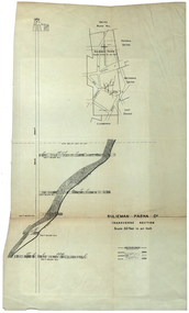
Plan, Sulieman Pasha Co Plan Transverse Section
The Sulieman Pasha is possibly named after the most important Sultan of the Ottoman Empire, Suleiman One, or Suleiman the Magnificent, when the Ottoman Empire was at its peak. Or potentially a number of Ottoman governors, statesmen and military commanders with the same name after, however the spelling is slightly different to the mine name. No Turkish connection was found relating to the formation of the company, and remains unconfirmed. The mine operated from two shafts; No. 1 near the corner of Humffray and Mair streets, and also near where the Welcome Nugget (2217 ounces) was found years earlier; and the controversial No. 2 shaft several blocks south bordering the northern side of the main highway through Ballarat. The company produced 62 666 ounces of gold, the twelfth highest quartz reef gold production for any mine on the Ballarat goldfield. Some crushing figure examples are January-June 1881: 3674 tonnes 1085 ounces; January-June 1885: 2949 tonnes 1281 ounces; July-December 1885: 4459 tonnes 1119 ounces; January-June 1887: 1869 tonnes 730 ounces; July-December 1892: 1450 tonnes 771 ounces; July-December 1896: 4365 tonnes 1372 ounces. Like many mines in the area, gold grades were low. John Watson was noted as mine manager in the 1880s, and John Williams 1890s. The company was re-organised twice increasing the number of shares from 4000 to 24 000, and increasing the capital available. The Sulieman Pasha Company was formed in 1878. David Fitzpatrick was given the honour of turning the first sod of both the No.1 and later No. 2 shafts. The first dividend was given to shareholders in July 1881. The company obtained a prospecting vote (government grant) to start, and was very proud to be the first Victorian gold mining company to pay the funds back to the government. The event was marked by a lavish banquet laid out for ministers and government officials by the company. Leases were purchased to the south in 1885 to the Llanberris Mine boundary, after poor results began accumulating from the small No. 1 shaft. To take advantage of this new land the company planned to sink a second shaft. Initially this was to take place on government land, but the uproar from nearby residents caused the company to purchase land along the Main Road (now Western Highway), and the old Yarrowee Hotel which had occupied the site since the alluvial digger days of the 1850's was demolished. The area had since those days become heavily occupied with a number of shops, houses, a post office, church and two schools in the immediate area. The thought of an underground mine next door drew considerable opposition. The company (before the days of public relations departments) wrote 'most people would have thought that progress as vital as mining would be supported by tradesmen whose business rely on the mining industry. It seems when it comes to mining they are bereft of their senses, and considering the low ebb of mining in Ballarat East, the action of our opponents are unaccountable. (Sarcastically) There are certain engineering difficulties in moving the quartz reefs to a new location, but if we could to appease our opponents we would'. The company also wanted to take over 4 acres of the St Paul's school oval for machinery, but accused the St Paul's Church of wanting extortionate amounts of money upfront, and on a yearly basis for the privilege. It stated the church could not be opposed to mining when several years earlier it had formed its own company to mine the land, only for shareholders to lose their money. In 1886, the company approached the Minister for Mines, and attended heated public meetings on the matter. The local residents, shop owners, and church submitted a 60 person petition to the local council and government authorities. They stated the shaft contravened the mining statutes, which stating no mining could take place within 150 yards of a public building or church. A speech by a resident stated 'mining always comes with glorious pictures of the great benefits which would accrue all parties concerned if their request is granted, but if property is destroyed or depreciated in value, no-one then comes forward and compensates them'. The No. 2 shaft was approved including taking over part of the school oval. In 1888, workers at the company's No. 2 shaft went on strike to try and bring their wages in line with other mines in the district (the No. 1 shaft was operated by tributers). William Madden (26) was killed from a fall of earth underground the same year, while a year later his father John Madden (70) was similarly killed in the Madame Berry Mine elsewhere in the district. In 1897 as the amount of gold being found fell away, it came to light part of the deal to purchase the Yarrowee Hotel site was a 5% royalty on gold found. Shareholders could not understand why they were paying a royalty to the former owners of the property. The mine closed in 1898 due to a lack of gold. In 1902 a boy (age unknown) called Charles Lee was killed from a fractured skull while working to dismantle the Sulieman Pasha plant. The fuss over the No. 2 shaft had a sequel. On the company winding up, the land was purchased by J.S. Trethowan who built a house next to the shaft. In 1907, the shaft caved-in creating a sinkhole immediately at the back of the house. A Mr Chamberlain heard a deep rumbling sound at 5am, and looked out the window to see his fowl house and thirteen chickens disappear down an expanding hole. He then went back to bed, and called the police later in the day. The shaft was 1050 feet deep, and the hole at the surface that developed was 20 feet by 17 feet across, and 20 feet depth. In 1930 it is reported a syndicate had been formed to clean out the old shaft, and re-open the mine. It is assumed this was the No. 1 shaft but no more was found. (https://www.mindat.org/loc-304239.html, accessed 07/08/2019) A transverse section plan of the Sulieman Pasha Mine.sulieman pasha company, plan, mining, united black hill mine, victoria united mine, victoria street, britannia united mine, last chance mine, llanberris mine, ottoman empire, john watson, john williams, david fitzpatrick -
 Ringwood and District Historical Society
Newspaper, Scrapbook Clipping, Library Collection, Ringwood, Victoria
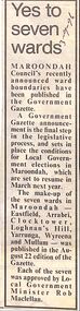
Newspaper Clipping from the "Mail", 03-09-1996. P5. Yes to seven wardsMaroondah Council's recently announced ward boundaries have been published in the Government Gazette. Each of the seven was approved by Local Government Minister Rob Maclellan -
 Ringwood and District Historical Society
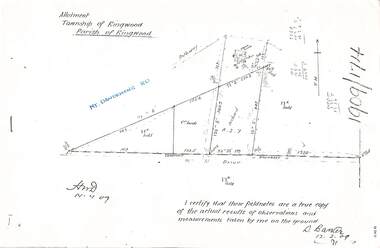
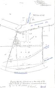
Document - Copy of Lands Department Field Notes - Parish of Ringwood, Victoria, Field Notes 1909/174 - Part of O.P. R72D surveyed 12.3.1909
Foolscap size photocopy of survey map with handwritten notations. References include Mount Dandenong Road, pathway, 2 room house, scillion, shed, WC, 17C sold, Cr lands, orchard, 17E sold, Township boundary, I certify that these field notes are a true copy of the actual results of observations and measurements taken by me on the ground (signed) D. Barker 12.3.09. -
 Ringwood and District Historical Society
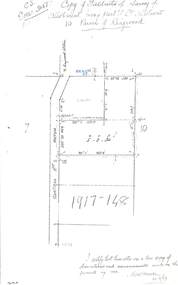
Document - Copy of Lands Department Field Notes - Parish of Ringwood, Victoria, Field Notes 1917/148 - Part of O.P. R72 - Crown Allotment 10, surveyed June 1917
5614b Foolscap size photocopy of survey map with handwritten notations. References include Wantirna Road, to Ringwood Station, Reilly Street, J. Marshall, fence to be erected on boundary, I certify that these notes are a true copy of observations and measurements made on the ground by me (signed) H.W. Moore 22/6/17. -
 Ringwood and District Historical Society
Document - Copy of Lands Department Field Notes - Parish of Ringwood, Victoria, Field Notes - OP34838 - surveyed in 1919 by D. Barker
5615b Foolscap size photocopy of survey map with handwritten notations. References include Braeside Avenue, Mount Dandenong Road, Rosedale Court, Railway Avenue, cyclone fence, Sec A, WB house, old tennis court netted, stable, old shed, tank stand, orchard, Township Boundary, netting fence, Railway fence, Ringwood to Lilydale Railway, I certify that these fieldnotes are a true copy of the actual results of observations & measurements taken by me on the ground (signed) D. Barker (1919). -
 Ringwood and District Historical Society
Newspaper, Scrapbook Clipping, Library Collection, Ringwood, Victoria, `
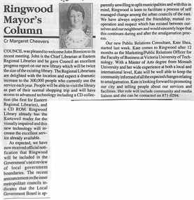
``Newspaper clipping from "The Post" 6-7-94 P9 Ringwood Mayor's Column. Cr Margaret Cheevers.Cr Cheevers welcomed John Binnion to the Ringwood library. He gave an excellent report on the progress of the new library.The Mayor also mentioned that Ringwood was in the government's next review of local government boundaries. A new Public Relations Consultant, Kate Shea, was welcomed to Ringwood Council` -
 Ringwood and District Historical Society
Newspaper, Scrapbook Clipping, Library Collection, Ringwood, Victoria, `
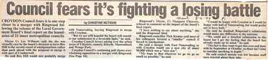
``Newspaper clipping from "The Mail" 8 -6- 94 P1 - Council fear's it's fighting a losing battle by Christine McTigheCroydon Council fears it is one step closer to a merger with Ringwood following the release of the Local Government Board's final report on the boundaries of 21 inner metropolitan councils. Croydon Mayor Cr Les Wilmott favors taking over the urban areas of Lilydale, namely Kilsyth, Mooroolbark and Wonga Park. The council fears that the Board has made up its mind to a merger between Croydon and Ringwood, which the councils don't want.` -
 Ringwood and District Historical Society
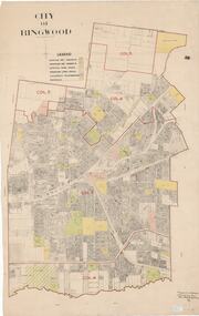
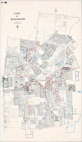
Map, City of Ringwood - Rateable Properties Layout - c.1966. Overlay showing Reserves, Open Space, Playgrounds, and Schools
A0-size (approx) map of named streets, lot-numbered properties and locality features within City of Ringwood boundary. Colour-coded legend identifying Existing Rec Reserves, Proposed Rec Reserves, Existing Open Space, Children's Playgrounds, and Schools.Scale: 8 chains to 1 inch. Map picked up in Engineer's office at old town hall prior to demolition 1971. -
 Ringwood and District Historical Society
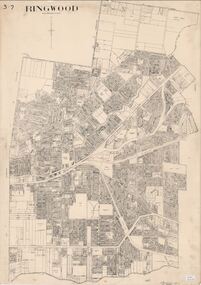
Map, City of Ringwood - Rateable Properties Layout - c.1966
A0-size (approx) map of named streets, lot-numbered properties and locality features within City of Ringwood boundary. Scale: 8 chains to 1 inch. City Engineer's signature in bottom right corner - Alan Robertson (City Engineer 1958-1987) -
 Ringwood and District Historical Society
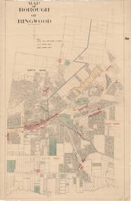
Map, Borough of Ringwood, Victoria - c.1950s
A0-size (approx) map of named streets and lot-numbered properties within Borough of Ringwood ward boundaries. Colour-coded key marking Land Under Control of Council, Factory Areas, and Business Areas.Scale: 8 chains to 1 inch. North Ward, East Ward, South Ward. -
 Ringwood and District Historical Society
Map, City of Ringwood - Rateable Properties Layout - c.1966
A0-size (approx) map of named streets, lot-numbered properties and locality features within City of Ringwood boundary. Coloured outlines of subsequent subdivisions. Seperate enlargement showing northern half of map.Scale: 8 chains to 1 inch. -
 City of Moorabbin Historical Society (Operating the Box Cottage Museum)
Book, compiled by Sandra Eldridge ( 2000- 2002), Bentleigh Secondary College a History 1950's to 2002, 2002
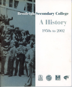
This is a medium soft cover book with a vertical wide green stripe down the front,on this green stripe is a sepia style print ( black) of school children in a large group, at the top of the cover is the title of the book in black and white writing,at the bottom of the cover are four badges depicting the four name changes the school had over that time frame, the back cover is the same as the front the only writing is a small acknowledgement to the compiler in the bottom left hand corner.non-fictionbentleigh, school, history, secondary, college, moorabbin, technical, boundary, sport, t.a.f.e. -
 City of Moorabbin Historical Society (Operating the Box Cottage Museum)
Newsletter, City of Moorabbin Historical Society No. 9 Vol.5 December 1965, City of Moorabbin Historical Society Newsletter No.9 Vol. 5 December 1965, 1965
This is Newsletter No 9 Vol . 5 produced in December 1965 by Mr T. A. Sheehy CMHS for members and visitors The Aims of the CMHS are ‘to record the history of the City, and register something of the Australian Atmosphere, which the necessary speed-up in post-world-war two (WW11) immigration has caused to be lost; to produce a magazine at regular intervals, featuring the work of pioneers and the changing Australian scene; to work constantly with a long range view towards building a hall where records and exhibits can be housed’ (1961) Topics ; 1965 in review; fourteen new organizations formed in City of Moorabbin; Moorabbin Community Hospital; CMHS Junior Citizens Scheme; vandalism in Moorabbin, Sport, 'Moorabbin News' Newspaper; This is Newsletter No. 9 Vol.5 of the CMHS December 1965 CMHS obtained a Kingston City Council Community Grant 2016 for the digitization and preservation of these Original CMHS Newsletters commenced in 1961 2 x L 26cm x W 21cm page 1 printed both sides CITY OF MOORABBIN HISTORICAL SOCIETY / AFFILIATED WITH THE ROYAL HISTORICAL SOCIETY OF / VICTORIA AND THE CHELTENHAM ARTS AND CRAFTS SOCIETY/ President Mrs N. Blackman….Editor of Newsletter Mr T.A.Sheehy Secretary Mrs F.Neville / VOLUME 5 No.9 NEWSLETTER DECEMBER 1965city of moorabbin historical society 1961, sheehy t.a., newsletters, blackman n ,neville f, moorabbin city council, moorabbin community hospital, moorabbin associations, moorabbin arts festival, victorian electoral boundaries 1965, moorabbin news 1965, turner road swimming pool, -
 City of Moorabbin Historical Society (Operating the Box Cottage Museum)
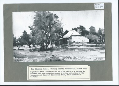
Photograph, B/W Watercolour,'Spring Grove' Charman Cottage built c1855 E Barlow c 1900, Elsie Barlow, c1900
... Road Cheltenham was a boundary of their land. moorabbin ...This is a B/W photograph of a Water colour by Elsie Barlow c 1900. The original water-colour is in the collection of the Beaumaris and District Historical Trust in the State Library of Victoria. 'Spring Grove' was the home of the Charman family in the Parish of Moorabbin. Stephen Charman, aged 21years, arrived in Melbourne in 1842 as one of Henry Dendy's Emigrants. 1852 he purchased 160 acres for £328 bounded by Charman Rd and Balcome Rd. 'The Spring' was an important water source for the local Aboriginal people and then for the early settlers. Charman's first wife Harriet and their infant child died and in 1850 he married a widow with 5 children, Mary Gettens. Their first home was made of wattle and daub and they had 7 more children. Later a weatherboard cottage was built c 1855 Together they developed a market garden and specialized in marigolds which were sold for medicinal purposes to the Melbourne Chemists - Martin & Pleasance . The first Methodist Church Services were held at Spring Grove and the Charmans donated land in 1857 for the first Chapel, Cemetery and Primary School . Mary died 1870 and Stephen married again and moved to Gippsland where he died aged 85 in 1906Stephen and Mary Charman were pioneer market gardeners in Moorabbin Shire 1842 and were involved in the development of Church, school and community in the area now called Cheltenham. Charman Road Cheltenham was a boundary of their land. Black & White photograph of a Watercolour of Charman family cottage built 1885 Cheltenham Signed E Barlow on back ; A Cottage in Charman Road - the Dandelion Season / by Elsie Barlow / In the Collection of the State Library Victoria / Reproduction requires the permission of the Library Moorabbin Standard Newspaper moorabbin, cheltenham, dendy henry, dendy's special survey 1841, assisted emigrants early settlers, pioneers, market gardeners, marigold flowers, pharmacy, charman stephen, gettens mary, charman harriet, methodist church, primitive methodists, box william, box elizabeth, state schools, education, moorabbin shire, moorabbin roads board, city of moorabbin, kingston city council -
 City of Moorabbin Historical Society (Operating the Box Cottage Museum)
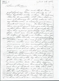
Document, Photocopy Letter Stephen Charman to Michael Charman UK 1853, 1853
... Cottage Museum) Joyce Park Jasper Road Ormond melbourne Stephen ...Stephen Charman, aged 21 years arrived in Melbourne in 1842 as one of Henry Dendy's emigrants. He established purchased land in 1852 and established a market garden at Spring Grove Cheltenham with his 2nd wife Mary nee Gettens. Stephen died 1906 in Gippsland. He wrote letters to his brother Michael who had remained in England Stephen and Mary Charman were pioneer market gardeners in Moorabbin Shire 1842 and were involved in the development of Church, school and community in the area now called Cheltenham. Charman Road Cheltenham was a boundary of their land. Letter, handwritten from Stephen Charman to his brother Michael in UK 1853 x 3 pages Handwritten signed Stephen early settlers, pioneers, spring grove, city of moorabbin, county of bourke, moorabbin roads board, parish of moorabbin, shire of moorabbin, henry dendy's special survey 1841, were j.b.; bent thomas, o'shannassy john, king richard, charman stephen, charman mary, gettens mary, marigold flowers, pharmacy, methodist church, state schools, education, highett william, ormond francis, maynard dennis, market gardens, -
 City of Moorabbin Historical Society (Operating the Box Cottage Museum)
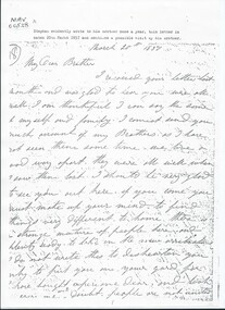
Document, Photocopy Letter Stephen Charman to Michael Charman UK 1857, 1857
... Road Cheltenham was a boundary of their land. moorabbin ...Stephen Charman, aged 21years, arrived in Melbourne in 1842 as one of Henry Dendy's Emigrants. 1852 he purchased 160 acres for £328 bounded by Charman Rd and Balcome Rd. 'The Spring' was an important water source for the local Aboriginal people and then for the early settlers. Charman's first wife Harriet and their infant child died and in 1850 he married a widow with 5 children, Mary Gettens. Their first home was made of wattle and daub and they had 7 more children. Later a weatherboard cottage was built c 1855 Together they developed a market garden and specialized in marigolds which were sold for medicinal purposes to the Melbourne Chemists - Martin & Pleasance . The first Methodist Church Services were held at Spring Grove and the Charmans donated land in 1857 for the first Chapel, Cemetery and Primary School . Mary died 1870 and Stephen married again and moved to Gippsland where he died aged 85 in 1906 Stephen and Mary Charman were pioneer market gardeners in Moorabbin Shire 1842 and were involved in the development of Church, school and community in the area now called Cheltenham. Charman Road Cheltenham was a boundary of their land. Letter, handwritten from Stephen Charman to his brother Michael in UK 1857 x 3 pageshandwrittenmoorabbin, cheltenham, dendy henry, dendy's special survey 1841, assisted emigrants, early settlers, pioneers, market gardeners, marigold flowers, pharmacy, charman stephen, gettens mary, charman harriet, methodist church, primitive methodists, box william, box elizabeth, state schools, education, moorabbin shire, moorabbin roads board, city of moorabbin, kingston city council, charman michael, cancel -
 City of Moorabbin Historical Society (Operating the Box Cottage Museum)
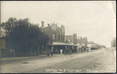
Photographs , Postcards x4 Charman Rd Cheltenham c 1910, c1910
... Road Cheltenham was a boundary of their land. fairlam p ...After the arrival of the Cheltenham Railyway Station Charman Road became the main shopping centre. From 1 small shop - Mrs Meeres who sold sweets, school requisites and drapery - it proceeded to develop throughout the 1890's with various traders until the 1910 Postcards show many shops on both sides of the road, Stephen Charman, aged 21years, arrived in Melbourne in 1842 as one of Henry Dendy's Emigrants. 1852 he purchased 160 acres for £328 bounded by Charman Rd and Balcome Rd. 'The Spring' was an important water source for the local Aboriginal people and then for the early settlers. Charman's first wife Harriet and their infant child died and in 1850 he married a widow with 5 children, Mary Gettens. Their first home was made of wattle and daub and they had 7 more children. Later a weatherboard cottage was built c 1855 Together they developed a market garden and specialized in marigolds which were sold for medicinal purposes to the Melbourne Chemists - Martin & Pleasance . The first Methodist Church Services were held at Spring Grove and the Charmans donated land in 1857 for the first Chapel, Cemetery and Primary School . Mary died 1870 and Stephen married again and moved to Gippsland where he died aged 85 in 1906 Stephen and Mary Charman were pioneer market gardeners in Moorabbin Shire 1842 and were involved in the development of Church, school and community in the area now called Cheltenham. Charman Road Cheltenham was a boundary of their land.4x Black & White Postcards c 1910 of Charman Road Cheltenham VictoriaFront; CHARMAN RD. CHELTENHAM P. FAIRLAM PHOTOfairlam p, cheltenham railway station, moorabbin, cheltenham, dendy henry, dendy's special survey 1841, assisted emigrants early settlers, pioneers, market gardeners, marigold flowers, pharmacy, charman stephen, gettens mary, charman harriet, methodist church, primitive methodists, box william, box elizabeth, state schools, education, moorabbin shire, moorabbin roads board, city of moorabbin, kingston city council, cancel, cheltenham primary school -
 City of Moorabbin Historical Society (Operating the Box Cottage Museum)
Clothing - Clothing, girl's party dress c 1927, 1927
... -roomed house in East Boundary Road, in the area then called East ...This child's green, silk, party dress was worn by Sylvia Marriott in 1927. The Marriott family were early settlers in the Moorabbin ShireMembers of the Marriott family arrived in Port Phillip in 1857. However it was John and Jane Marriott who in 1876, (after toiling hard since their arrival in1871, for very little gain), first leased, then purchased in 1882, 30 acres with a four-roomed house in East Boundary Road, in the area then called East Brighton. (Now known as East Bentleigh). The land they purchased had previously been a part of the 1841 Dendy Special Survey. Over the following years, John and his four sons with hard work and determination became prosperous vegetable growers and purchased further land in the area. Following John's retirement and subsequent death in 1903, the land was passed to his sons, and then onto the Marriott grandchildren. The family continued to remain very prosperous and successful vegetable growers and are one of many families steeped in the tradition of vegetable growing which significantly contributed to the prosperity of the Moorabbin ShireA home-sewn pale green silk party dress, worn to a wedding by four year old, Sylvia Marriott c 1927. The skirt of the dress has layers of ruffles. It has short cap sleeves. Decorative ribbons are attached at the shoulder continueing to the waist, then hang loosely over the skirt of the dress. Small pink and white ribbon rose buds have been applied at the neckline, waist and the edges of the sleeves .brighton, moorabbin, marriott, clothing, market gardeners, home, dressmaker, needlework, dendys special survey -
 City of Moorabbin Historical Society (Operating the Box Cottage Museum)
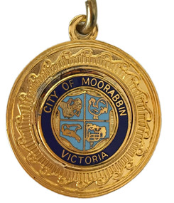
Badge - City of Moorabbin Key Chain
“City of Moorabbin” The township of Moorabbin, known as South Brighton until 1909, remained small, with the Plough and Harrow Hotel as its main building. In 1917 Sandringham borough was formed by severance from Moorabbin shire and in 1920 Mentone and Mordialloc were also severed. In the remaining Moorabbin shire the Moorabbin township was still small (1,770 persons), but the shire grew in population during the 1930s. On 10 October 1934 it was proclaimed a city. It existed as a separate municipality until 1995. When local government boundaries were changed in 1994 about half of Moorabbin city was united with Glen Eira city and about half with Kingston city. On 15 December, 1994 the City of Chelsea, parts of the Cities of Mordialloc, Moorabbin, Springvale and Oakleigh were amalgamated to create the City of Kingston by Order of the Governor in Council. On the same day Glen Eira City Council was formed from the City of Caulfield and the remaining part of the City of Moorabbin.Gold Key ring with a dark blue circle surrounding the shield of the City of Moorabbin.City of Moorabbin, Victoria,city of moorabbin -
 City of Moorabbin Historical Society (Operating the Box Cottage Museum)
Programme - Two Programs for Mayoral Functions held in the City of Moorabbin. 1946 & 1953, City of Moorabbin Council, 1946 & 1953
“City of Moorabbin” The township of Moorabbin, known as South Brighton until 1909, remained small, with the Plough and Harrow Hotel as its main building. In 1917 Sandringham borough was formed by severance from Moorabbin shire and in 1920 Mentone and Mordialloc were also severed. In the remaining Moorabbin shire the Moorabbin township was still small (1,770 persons), but the shire grew in population during the 1930s. On 10 October 1934 it was proclaimed a city. It existed as a separate municipality until 1995. When local government boundaries were changed in 1994 about half of Moorabbin city was united with Glen Eira city and about half with Kingston city. On 15 December, 1994 the City of Chelsea, parts of the Cities of Mordialloc, Moorabbin, Springvale and Oakleigh were amalgamated to create the City of Kingston by Order of the Governor in Council. On the same day Glen Eira City Council was formed from the City of Caulfield and the remaining part of the City of Moorabbin.Official functions held in the City of Moorabbin 1946 & 1953Two program cards, one green 1946 and the other cream 1953. The inside lists the entertainment during the reception of the Mayoral functions of the City of Moorabbina) RECEPTION /given by the / MAYOR AND MAYORESS / of MOORABBIN / 1946 b) RECEPTION / given by the / MAYORESS of MOORABBIN / 1953mcc, marriott, ward, coates, city of moorabbin, reception, program cards, entertainment, market gardeners, early settlers, cheltenham, moorabbin, bentleigh -
 Running Rabbits Military Museum operated by the Upwey Belgrave RSL Sub Branch
Invasion Money
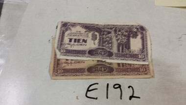
Japanese |Invasion money for Dutch East Indies !0 Guilder X2 (one with Japanese & English) hand writing on boundary.ephemera, ww2, general -
 Bendigo Historical Society Inc.
Newspaper - NEWSPAPER CLIPPINGS EARLY PHOTOGRAPHS OF BENDIGO STREETSCAPE, Unknown
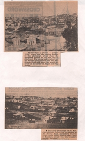
Two Black & White Early Photographs of Bendigo. (Photograph 1) Panorama is taken from the Masonic Hall location with the Rifle Brigade Hotel on the corner of Rowan and View Streets and Knipe's Folly in top right of image. (Photograph 2) An early photograph of the Bendigo Goldfields the suburb of Ironbark taken from the vicinity of Mt. Korong Road, overlooking Victoria Street and Quick Street. Image shows Knipe's Castle in Boundary Street ''on the Ironbark Ranges'' top right.bendigo, streetscape, rowan & view st, mt korong rd -
 Bendigo Historical Society Inc.
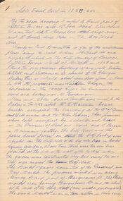
Document - LET'S TRAVEL EAST IN 1858 - 60'S
... Mitchell Street, along Lyttleton Terrace and McIvor Road... Lyttleton Terrace and McIvor Road to the City boundary ...Nine pages of handwritten account of businesses from Mitchell Street, along Lyttleton Terrace and McIvor Road to the City boundary on the Bendigo side of Murphy Street.document, let's travel east in 1858 - 60's, moorabbee sheep run, curr's sheep run, glasgow bakery, lachlan frazer, mr hardiman, steen and holm coach painters, mr h haisman coach builder, scholton and march, march and s brown, haisman factory, city hall, police court, city lockup, market square, senior citizens club, weighbridge, dunlop tyre service station, tommy burns, matt lynch, tom & mick kennedy, darling hotel, the innes, mr bullens fruit shop, bricklayers arms hotel, cheshire arms hotel, mr i boffey, newcombe's timber yard, quinns monumental establishment, alexandra fountain, cumberland hotel, sannaman's coach factory, town hall hotel, her majesties open air picture show, mr r anderson, john ohagan, sandhurst hotel, the melbourne café, haymarket hotel, the old haymarket hotel, the market ale house, the prince of wales theatre, manchester hotel, mr john doran, dr backhaus, manchester hall, the bendigo star, james griffen coach factory, mr george lansell, whitting's marine store, cartrights marine store, sandhurst flour mills, mr john buckley, moorhead hay and corn mills, brian boru hotel, mr m r?dea, mr worth, mr condon, mr c cahill, nolan family, mr sides, the nailons, mrs boyan, jacky bryant, john oconnell general store, mr pierce, mr matthews, mr neil ward, mr hagan, william clapton, mr joseph dowd, mr morris, ancient briton hotel, the woolpak, the railway bridge, ampol service station, farrells dairy, farringtons brickworks, jacksons hide & tallow yard, fergusons, royal oak hotel, mr jackson, mr knight, st marys common school no812, mrs rersol, w d quinn, mr march, mr fred randall, mr steeple, the limerick hotel, back creek police shooting range, police station, stone lockup, holts service station, steepe's butcher shop, joch, john hattam -
Bendigo Historical Society Inc.
Map - MAP WHITE HILL TO HUNTLY
Map of Bendigo creek and adjacent leads - White Hills to Huntly replotted from old 4 chain to 1 inch survey of 1860 by G. W. Hart - Surveyor. Base of roads and streets taken from D.L.S. 1 . 10000 base maps. Legend: battery site, puddling mill site, dam bank site, cutting altering course of creek, lead boundaries.bendigo, mining -
Port Melbourne Historical & Preservation Society
Photograph - J Kitchen & Sons site, Port Melbourne, 1978
Large black and white aerial photo in narrow gold-coloured metal frame of J Kitchen & Sons Pty Ltd factory . Port Melbourne Football/Cricket ground top left of photo . Photo taken approx 1978 or later, dated due to types of cars and by comparison with buildings along Boundary St opposite as shown in photos of catalogue iten 3202. Dated also by Glen Cosham who was a Councillor when Woodruff St was sealed and this did not occur until after Oct 1977, probably early 1978. It was paid for by the Country Roads Board as part of the preparations for the opening of the West Gate Bridge and the Johnson St Bridge later that year.industry - manufacturing, built environment - industrial, j kitchen & sons pty ltd, pental products pty ltd, symex, north port oval -
Port Melbourne Historical & Preservation Society
Plan - Tramway, Normanby Road, Ingles Street to Boundary Street, Port Melbourne, 14 Mar 1893
... Tramway, Normanby Road, Ingles Street to Boundary Street... of tramway in Normanby Road from Ingles Street to Boundary Street ...Plan of tramway in Normanby Road from Ingles Street to Boundary Street, together with written specification for works attached (Reg 66.2), 1893.A.V. Heath (Town Surveyor) J.J. Bartlett (Mayor)engineering - roads streets lanes and footpaths, transport - tramways, town planning, town clerks, mayors, arthur victor heath, james john bartlett -
Port Melbourne Historical & Preservation Society
Document - Specification, Tramway, Normanby Road, Ingles Street to Boundary Street, Port Melbourne, 14 Mar 1893
... Specification, Tramway, Normanby Road, Ingles Street to... Engineering - Roads Streets Lanes and Footpaths Transport - Tramways ...Written specification for works attached to plan of tramway in Normanby Road from Ingles Street to Boundary Street (Reg 66.1), 1893.A.V. Heath (Town Surveyor) J.J. Bartlett (Mayor)engineering - roads streets lanes and footpaths, transport - tramways, town planning, town clerks, mayors, arthur victor heath, james john bartlett -
Port Melbourne Historical & Preservation Society
Document - Specification, Metalling and chanelling, Boundary Street South, Graham Street to St Vincents Street, Arthur Victor Heath, Town Clerk et al, 14 Mar 1893
Specifications (Reg. 77.1) and plan (Reg 77.2) for metalling and channelling Boundary Street South [Pickles Street] from Graham Street to St. Vincents Street. Loan works 1893, plan No. 5.A.V. Heath (Town Surveyor):J.J. Bartlett (Mayor)engineering - roads streets lanes and footpaths, town planning, town clerks, mayors, arthur victor heath, james john bartlett -
Port Melbourne Historical & Preservation Society
Plan - Metalling and chanelling, Boundary Street South, Graham Street to St Vincents Street, 14 Mar 1893
Specifications (Reg. 77.1) and plan (Reg 77.2) for metalling and channelling Boundary Street South [Pickles Street] from Graham Street to St. Vincents Street. Loan works 1893, plan No. 5.J.J. Bartlett (Mayor) 14/3/93engineering - roads streets lanes and footpaths, town planning, town clerks, mayors, arthur victor heath, james john bartlett -
Port Melbourne Historical & Preservation Society
Plan - Metalling and channelling Evans Street from Ingles Street to Boundary Street, 14 Mar 1893
Specifications (94.1) and Plan (94.2) for metalling and channelling Evans Street from Ingles Street to Boundary Street . Loan Works 1893. Plan number 8.Both signed by J.J. Bartlett. (Mayor).engineering - roads streets lanes and footpaths, town planning, town clerks, mayors, arthur victor heath, james john bartlett