Showing 3407 items
matching bridge road
-
 Eltham District Historical Society Inc
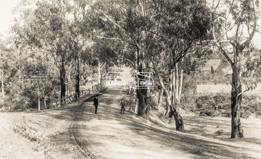
Photograph, Monash Bridge, Hurstbridge-Arthurs Creek Road, Hurstbridge
... Monash Bridge, Hurstbridge-Arthurs Creek Road, Hurstbridge... arched bridge hurstbridge hurstbridge arthurs creek road monash ...Black and white photographinfrastructure, shire of eltham infrastructure, bridge, arched bridge, hurstbridge, hurstbridge arthurs creek road, monash bridge -
 Eltham District Historical Society Inc
Photograph, Russell Yeoman, Mountain View Road railway bridge, Montmorency, c.1970, 1970c
... Mountain View Road railway bridge, Montmorency, c.1970... melbourne bridge bridges Montmorency Mountain View Road railways ...Roll of 35mm black and white negative film, 4 of 7 stripsIlford HP4bridge, bridges, montmorency, mountain view road, railways -
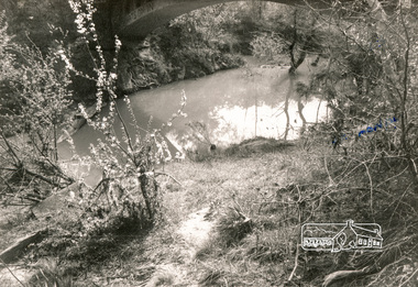
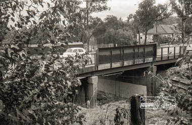
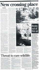 Wonga Park Community Cottage History Group
Work on paper - Newspaper cutting, Wonga Park: May 1999, Warrandyte Diary: "New Crossing Place" New bridge for Jumping Creek Road
... " New bridge for Jumping Creek Road... Old Yarra Road Wonga Park melbourne Wonga Park: May 1999 ... -
 Eltham District Historical Society Inc
Photograph - Photograph postcard, The Rose Stereograph Company, View at Eltham, Vic. Postcard sent from Ernest and family to Joe, 3 May 1936, c.1920
... main road bridge... the original Main Road Bridge and the Diamond Creek from near... the original Main Road Bridge and the Diamond Creek from near ...Postcard sent from Ernest and family to Joe, 3 May 1936. Original photo estimated to be circa 1920. Looking west across the original Main Road Bridge and the Diamond Creek from near the intersection of Antoinette Boulevard. To the right of the bridge appear to be orchard trees in flood waters. The long wooden suspension bridge over the Diamond Creek on Main Road at Eltham collapsed during flooding of the Diamond Creek on October 13 and 14, 1923. The original bridge was built around 1840 for the coach road when Cobb & Co.'s coach was the only conveyance between Eltham and Melbourne. Widespread damage was done in Melbourne and surrounding areas by floods resulting from the overflow of the Yarra at many points along its banks. A temporary bridge rigged up was severely damaged by the flooding of the creek and was closed to vehicular traffic in April 1924. A new concrete bridge was constructed to replace it and by May 1926 all the concrete piles and abutments had been completed. The bridge was finally completed and opened for traffic in September 1926, almost three years after it initially collapsed. The Rose Series P. 4346 Postcards scanned from the collection of Michael Aitken on loan to EDHS, 13 Feb 2018Digital file only Postcards scanned from the collection of Michael Aitken on loan to EDHS, 13 Feb 2018michael aitken collection, postcards, main road bridge, main road, eltham, antoinette boulevard, diamond creek (creek), eltham south -
 Eltham District Historical Society Inc
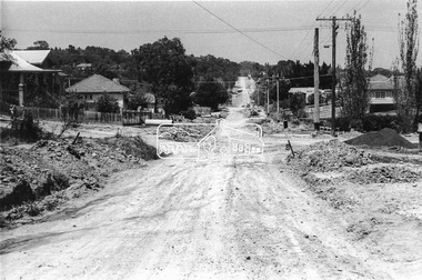
Photograph, Looking south along Bible Street towards intersection with Bridge Street, Eltham, c.September 1966, 1966c
... Bible Street, Bridge Street, Road construction, streets... area and crossed out Eltham-Yarra Glen Road, Bridge Street... melbourne Bible Street, Bridge Street, Road construction, streets ...Black and white photographic printOriginally located in a Filmpro King Size Prints processing envelope $3.01 Shire of Eltham 9/9/66 and noted as Calrossie Ave area and crossed out Eltham-Yarra Glen Road, Bridge Street to Elsa Court existing conditions mid 1967bible street, bridge street, road construction, streets -
 Eltham District Historical Society Inc
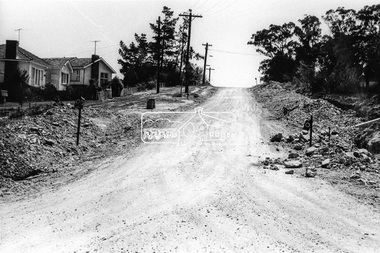
Photograph, Looking west along Bridge Street from intersection with Bible Street, Eltham, c.September 1966, 1966c
... Bible Street, Bridge Street, Road construction, streets... area and crossed out Eltham-Yarra Glen Road, Bridge Street... melbourne Bible Street, Bridge Street, Road construction, streets ...Black and white photographic printOriginally located in a Filmpro King Size Prints processing envelope $3.01 Shire of Eltham 9/9/66 and noted as Calrossie Ave area and crossed out Eltham-Yarra Glen Road, Bridge Street to Elsa Court existing conditions mid 1967bible street, bridge street, road construction, streets -
 Eltham District Historical Society Inc
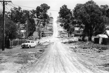
Photograph, Looking west along Bridge Street towards intersection with Bible Street, Eltham, c.September 1966, 1966c
... Bible Street, Bridge Street, Road construction, streets... area and crossed out Eltham-Yarra Glen Road, Bridge Street... melbourne Bible Street, Bridge Street, Road construction, streets ...Black and white photographic printOriginally located in a Filmpro King Size Prints processing envelope $3.01 Shire of Eltham 9/9/66 and noted as Calrossie Ave area and crossed out Eltham-Yarra Glen Road, Bridge Street to Elsa Court existing conditions mid 1967bible street, bridge street, road construction, streets -
 Tatura Irrigation & Wartime Camps Museum
Document, Waranga Conservation Study 1988. Volume 1, 1988
... on cover of Rimes farmhouse, Bakers Bridge Road Wanalta c 1874-8.... farmhouse, Bakers Bridge Road Wanalta c 1874-8. Waranga Conservation ...Recommendations and guidelines. A study of historical data on local conservation for Waranga Shores, includes early photos of houses in Murchison and RushworthWhite plastic back, Clear plastic on front. Picture on cover of Rimes farmhouse, Bakers Bridge Road Wanalta c 1874-8. -
 Eltham District Historical Society Inc
Book, Diamond Creek Basin Study. Part 1, A Compendium of Factors Relevant to Stormwater Flows, 1980
... arthurs creek road bridge... kinglake national park latiners hat factory main road bridge main ...Basin Studies are studies to evaluate water supply and demand and help ensure reliable water supplies by identifying strategies to address imbalances in water supply and demand.Spiral Bound. 157 leaves in various foliations (some folded) : illustrated. (some colour.), maps (some colour.)aerial photographs, allendale road, arthurs creek mine, arthurs creek road bridge, arthurs creek, bald spur look-out, bank protection, bolton steet, bridge street bridge, bridge street, bridges, challenger street, chute street, construction, coolaroo drive, culvert, deep creek, diamond creek basin, diamond creek region, diamond creek, diamond street bridge, drainage works, eltham lower park, eltham town park, eltham trestle bridge, eltham west drains, eltham, erosion, flood management, floods, footbridge, glen katherine estate, gold mining, gum glade, hurstbridge, kangaroo ground, kinglake escarpment, kinglake national park, latiners hat factory, main road bridge, main road, masons falls, melbourne metropolitan board of works, monash bridge, mount sugarloaf, nillumbik park, orchards, railway culvert, railway line, ramptons road, real estate advertisement, research creek, st helena east drain, st helena road, st helena, storm sewers, stormwater, sugarloaf-preston transfer main crossing, susan street, union mine, village pond, water flow, watkins street, wattletree road, weidlich road, wingrove park, yarra river, zig zag road, water supply, basin study -
 Eltham District Historical Society Inc
Folder, Colemans Corner, Eltham
... wattletree road bridge... to consultation on Wattletree Road Bridge replacement, 13 August 2007, 1p... to consultation on Wattletree Road Bridge replacement, 13 August 2007, 1p ...Letter from Nillumbik Council to H.Gilham in response to consultation on Wattletree Road Bridge replacement, 13 August 2007, 1p. VicRoads brochure on Wattletree Road bridge replacement project, August 2007, 1p Photo of "Coleman's house", 1904 with brief family history. (Photo retrieved by Harry Gilham from from a 1972 'time capsule bucket' found at the Eltham Shire Office during its demolition in July-August 1996 (See also SEPP_0745 and 1678A) Photo of "Coleman's house", 1971 Survey plan showing location of Coleman's houseFolder of information and photos relating to the Colemans Corner precinct located on the corner of Main Road and Wattletree Road, Eltham. HG Booklet 9bus services, wattletree road bridge, coleman family, coleman's corner, harry gilham collection -
Tatura Irrigation & Wartime Camps Museum
Document, Waranga Conservation Study. Volume 1, 1988
... on cover of Rimes farmhouse, Bakers Bridge Road, Wanalta C 1874-8.... Picture on cover of Rimes farmhouse, Bakers Bridge Road, Wanalta C ...Recommendations and guidelines. A study of historical data on local conservation for Waranga Shire. Includes early photos of houses in Murchison and RushworthWhite back cover, clear plastic over front cover. Picture on cover of Rimes farmhouse, Bakers Bridge Road, Wanalta C 1874-8waranga shire, documents, reports -
 Eltham District Historical Society Inc
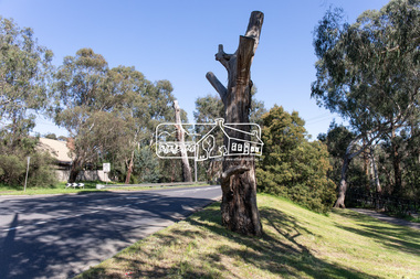
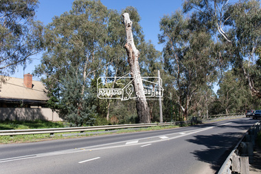
Photograph, Peter Pidgeon, Manna Gum, Main Road, Eltham South, 8 Sep. 2021
... main road bridge...This significant tree located near the Main Road Bridge... melbourne This significant tree located near the Main Road Bridge ...This significant tree located near the Main Road Bridge over the Diamond Creek at Eltham dates back to approximately 1870-1880. Though dead now, its trunk has been left as a wildlife habitat.These trees are not only significant for the natural environment but also present a navigational beacon back in time as the environmental landscape is developed around them.Born Digitaleltham south, main road bridge, manna gum, significant tree -
 Eltham District Historical Society Inc
Photograph, Peter Pidgeon, Manna Gum, Main Road, Eltham South, 8 Sep. 2021
... main road bridge...This significant tree located near the Main Road Bridge... melbourne This significant tree located near the Main Road Bridge ...This significant tree located near the Main Road Bridge over the Diamond Creek at Eltham dates back to approximately 1870-1880. Though dead now, its trunk has been left as a wildlife habitat.These trees are not only significant for the natural environment but also present a navigational beacon back in time as the environmental landscape is developed around them.Born Digitaleltham south, main road bridge, manna gum, significant tree -
Lakes Entrance Regional Historical Society (operating as Lakes Entrance History Centre & Museum)
Photograph, 1926 c
... railway bridge with road bridge visible behind at Bairnsdale... train going over railway bridge with road bridge visible behind ...Photograph taken from Bairnsdale wharf just downstream from bridge. Train heading back to Bairnsdale from Bruthen OrbostBlack and white photograph of steam train going over railway bridge with road bridge visible behind at Bairnsdale Victoriatopography, waterways -
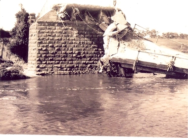 Federation University Historical Collection
Photograph - Photographs, Richard Vincent, Washed Away Bridge at Garibaldi, c1933
... to bridges and roads damaged by heavy flooding in 1933, in particular... and collapsed bridge/road. .2) mirror image of above .3) unknown man... bridge/road. .2) mirror image of above .3) unknown man waling ...Newspaper clipping documents deputations to the Minister of Public Works for grants to be made available for repairs to bridges and roads damaged by heavy flooding in 1933, in particular, the replacement of a stone and concrete bridge over the Leigh River at Garibaldi in the Buninyong Shire. The concrete slabs were still in the water in the 1960s/70s or even later. Three black and white photographs showing flood damage to the bridge over the Leigh River at Garibaldi, plus a photocopy of a newspaper clipping from The Argus December 1933 describing the extent of the flood damage. .1) shows blue stone buttress and collapsed bridge/road. .2) mirror image of above .3) unknown man waling an a girder of the Garibaldi bridge .4) photocopy of newspaper clipping about flood damage from The Argus December 1933Damage by Floods: Bridges washed away (The Argus December 1933)leigh river, garibaldi, buninyong shire, richard vincent, garibaldi bridge -
 The Beechworth Burke Museum
Photograph, c1900
... Bridge Road... machinery manufacturing Bridge Road Obverse: [Pin holes from ...Taken around 1858, depicting a row of five business buildings on a rocky, sloping hillside at New Town, with a view across to residences and open land. Businesses included, Joseph E. Bishop, Coach Builders; Straughair Duncan, Engineers, Blacksmiths & Farriers; Straughair Duncan, Beechworth Foundry; Wholesale & Retail Est. 1855, Mackenzie Family Store ; and T. Pratten, Grocer. The Mental Hospital can be seen in the background. Mark Straughair and John Duncan, established the Beechworth Foundry, Newtown in 1858 and went on to build an important industry, employing around sixteen men, after acquiring Alexander Roger's New Ford Street Foundry in the late 1860s. Making and repairing mostly mining and agricultural machinery for the Ovens District and a Beechworth brewery, the business continued to function after Straughair's death in 1882, up until the death of Duncan in 1896, when the business folded. This photograph is historically significant because it shows the development of the businesses in Beechworth from the early establishment of the town.Sepia rectangular photograph printed on photographic paper mounted on boardObverse: [Pin holes from circular tacks in all four corners] Reverse: 84.216-1/ Newtown/ 1997.2650/ 21/ BMM3056/new town, newtown, newtown beechworth, local business, 1858, 1850s beechworth, joseph e. bishop, coach builder, coach, mark straughair, m. straughair, straughair and duncan, john duncan, j. duncan, beechworth foundry, mackenzie family store, t. pratten, grocer, beechworth grocers, beechworth mental asylum, beechworth mental hospital, mayday hills mental asylum, mental hospital, alexander rogers, new ford street foundry, 1860s beechworth, 1860s, mining machinery, agricultural machinery, manufacturing, bridge road -
 Orbost & District Historical Society
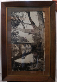
black and white photograph, first half 20th century
... bridge Snowy-River-Bridge road-transport-Orbost.... This bridge was built in the 1920s as a road and rail bridge.... This bridge was built in the 1920s as a road and rail bridge ...This is a bridge across the Snowy River at Orbost. This bridge was built in the 1920s as a road and rail bridge, and was partly washed away by flood waters in 1934. After the end of the first World War the Victorian Railways considered an extension of the railhead across the river at Orbost, and in 1922 a new timber and steel girder structure, a joint Country Roads Board — Victorian Railways venture, was built and completed at a cost of £41,000 (the steel girders came from the Flinders Street viaduct reconstruction). Subsequently it was decided not to take the railway across the river, and the bridge has only been used by road traffic.This is a pictorial record of an early bridge across the Snowy River at Orbost.A very large black / white photograph under glass in a timber frame. It is of a bridge across a river and is framed by trees.bridge snowy-river-bridge road-transport-orbost -
 Eltham District Historical Society Inc
Album - Photograph, J.A. McDonald, Healesville-Yarra Glen Road, Aug. 1958
... -1962 involving bridge and road reconstruction projects ...Long Gully Bridge August 1958Record of various Shire of Eltham infrastructure works undertaken during the period of 1952-1962 involving bridge and road reconstruction projects, sometimes with Eltham Shire Council Project Reference numbers quoted. It was during this period that a number of significant improvements were made to roads and new bridges constructed within the shire that remain in place as of present day (2022). In many situations, the photos provide a tangible visible record of infrastructure that existed throughout the early days of the Shire. The album was put together by or under the direction of the Shire Engineer, J.A. McDonald.infrastructure, shire of eltham, 1958-08, bridge construction, long gully bridge, road construction -
 Eltham District Historical Society Inc
Folder, Pioneers & Painters; Shire of Eltham Historical Society research notes, background information, etc, 1969-1986, 1969-1986
... bridge road.... thomas alan marshall bridge road charles joseph latrobe council ...Material pertaining to the production of a history of the Shire of Eltham, "Pioneers & Painters: One Hundred Years of Eltham and its Shire" in recognition of the shire's centenary in 1971 Item Title Caption 04768-1 Newspaper clipping - The Eltham of 1905; Gellibrand our first white visitor? Diamond Valley News, 24 June 1969, p5 04768-2 Newspaper clipping - The Eltham of 1905; Gellibrand our first white visitor? Heidelberger, 25 June 1969 04768-3 Notes on Eltham District Road Board Members 1866-1871 04768-4 Notes on Eltham District Road Board Members 1866-1871 04768-5 Map showing Gellibrand's likely route through district 12-13 February 1836 and Hoddles's route of Febrary 1838 04768-6 Notes by Shire Secretary, M.B. Watson regarding meeting with Reverend Longfield regarding history of St Margaret's Church 04768-7 Alan Marshall's notes from discussion with Mr. F. Barrett regarding SEPP images 611, 635 and 636 SEPP_0611 SEPP_0635 SEPP_0636 04768-8 Transcripts of letter from local residents to Charles Joseph Latrobe requesting a bridge over the Plenty River dated 10 April 1849 and his reply dated 5 May 1849; from Latrobe Library Archives - Land Branch Records 04768-9 Notes on history of Eltham Shire, Centenary events and publication of Pioneers & Painters for release in conjunction of opening of new Library 04768-10 Newspaper clipping - Glossy record of shire's romantic past and the people who made it by Fab Calafuri, Diamond Valley News, Tuesday, December 16, 1986, p18 SEPP_0755-3 Letter: Acknowledgement from Colin J. Bock, Eltham Shire Secretary to A.R. Thomas of Bendigo for copy of 1913 photograph of Shire of Eltham Councilors, 21 May 1973 A.R. Thomas' father Mr. A.G. Thomas, C.E., was the Shire Secretary at the time in 1913. Cross Ref: SEPP_0755 The idea to develop a book on the history of the Shire of Eltham to be edited by noted author, Alan Marshall in celebration of the shire's centenary was initiated in 1969. The Shire of Eltham Historical Society undertook significant research in conjunction with Alan Marshall locating material at various institutions and other societies; interviewing longer term residents and a public campaign through the local press to acquire photographic material for duplication and use in the book. The public campaign received generous response and the material collected became the genesis for the Shire of Eltham Pioneers Photograph collection now held in partnership between Eltham District Historical Society and Yarra Plenty Regional Library (Eltham Library).Paper documents of various sizes and newspaper clippingsa.g. thomas, a.r. thomas, alan marshall, bridge road, charles joseph latrobe, council members, d.w. lachlan, eltham district road board, eltham shire council, ernie orford, f. barrett, francis rogerson, g. bransprone, james donaldson, james johnston, john bell, john thomson, joseph tice gellibrand, lower plenty bridge, m.b. watson, main road, map, patrick turnbull, peter morris, pioneers and painters, post office, rev. longfield, sepp, shire of eltham pioneers photograph collection, shire secretary, st margaret's church, thomas armstrong, thomas bell, thomas sweeney, william bell (1796-1870), centenary celebrations, christmas hills, clifton pugh, david newbury, dudley street, eltham, gareth jones roberts, hurstbridge, john perceval, joy peck, kangaroo ground, kinglake, lower plenty, luther haley general store, montmorency, neil douglas, panton hill, peter glass, research (vic.), sheila ferguson, shire of eltham, st andrews, yarra glen -
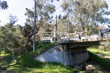
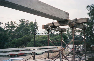
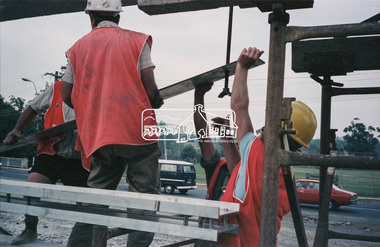
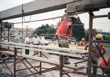
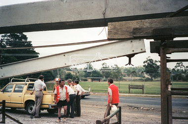
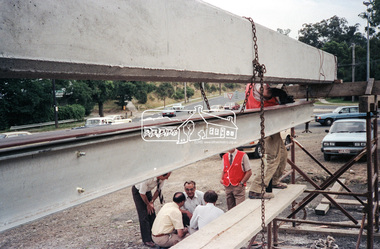
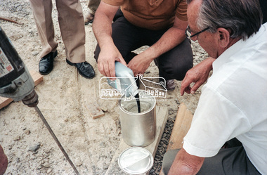
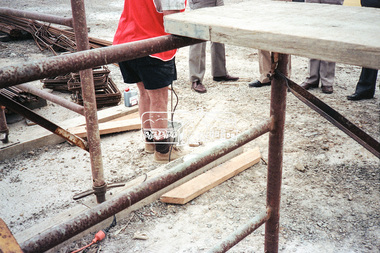
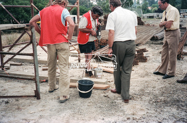
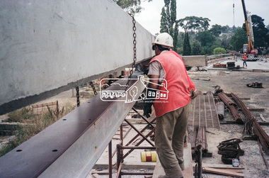
 Eltham District Historical Society Inc
Negative - Photograph, Construction work, Main Street Bridge, Greensborough, c.Dec. 1983
... the divided road across the river infrastructure roads bridge ...The original bridge over the Plenty River was replaced by a single lane bridge each way fed by two lanes each way on either side. As traffic grew a second bridge was added to complete the divided road across the riverFilm - Kodak CM 400 5079 7 strips, 26 framesinfrastructure, roads, bridge construction, greensborough, main street bridge, road construction -
 Eltham District Historical Society Inc
Negative - Photograph, Construction work, Main Street Bridge, Greensborough, c.Aug. 1978
... the divided road across the river infrastructure roads bridge ...The original bridge over the Plenty River was replaced by a single lane bridge each way fed by two lanes each way on either side. As traffic grew a second bridge was added to complete the divided road across the riverFilm - Kodak CM 400 5079 7 strips, 26 framesinfrastructure, roads, bridge construction, greensborough, main street bridge, road construction -
 Eltham District Historical Society Inc
Negative - Photograph, Construction work, Main Street Bridge, Greensborough, c.Dec. 1983
... the divided road across the river infrastructure roads bridge ...The original bridge over the Plenty River was replaced by a single lane bridge each way fed by two lanes each way on either side. As traffic grew a second bridge was added to complete the divided road across the riverFilm - Kodak CM 400 5079 7 strips, 26 framesinfrastructure, roads, bridge construction, greensborough, main street bridge, road construction -
 Eltham District Historical Society Inc
Negative - Photograph, Construction work, Main Street Bridge, Greensborough, c.Dec. 1983
... the divided road across the river infrastructure roads bridge ...The original bridge over the Plenty River was replaced by a single lane bridge each way fed by two lanes each way on either side. As traffic grew a second bridge was added to complete the divided road across the riverFilm - Kodak CM 400 5079 7 strips, 26 framesinfrastructure, roads, bridge construction, greensborough, main street bridge, road construction