Showing 418 items matching "digitised photograph"
-
 Melton City Libraries
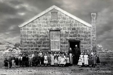
Photograph, Melton State School 430, 1870
... Robinson c 1980. In 2011 the original photograph was scanned... Robinson c 1980. In 2011 the original photograph was scanned ...Edna Barrie received this photo from Margaret nee McCoy Robinson c 1980. In 2011 the original photograph was scanned and digitised and restored by Morrie Forte. Norma ( Mothers’ Club Representative 1970) and Morrie Forte of Melton have been associated and supported the Melton State School No 430 and contributed to the 100 years celebrations. In December 2011 when viewing the enlarged restored print Mary Tolhurst identified brothers Andrew and Edward Byrns.[Burns] she is a descendent of this family. The brothers were enrolled at the Melton Common School in 1864 aged about 8 ½ and 5 years and left in 1870 and 1871. Head Teacher J H Murphy 1869-71Students in front of the bluestone buildinglocal architecture, education -
 Wodonga & District Historical Society Inc
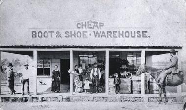
Photograph - Franz Gördes, Boot and Shoemaker, Wodonga
Franz Gördes (b.1843) who immigrated to Australia from Germany in 1871. After docking in Melbourne Franz headed for the goldfields at Spring Gully near Beechworth, but didn't strike gold. He returned to his trade and opened a boot shop in Wodonga, which burnt to the ground the day before the opening. Undeterred, he rebuilt and operated the business until his death on 8 June 1928. He was survived by his widow, Margaret as well as six sons and three daughters. Franz Gordes’ Boot & Shoe Warehouse was situated in Sydney Road, now High Street, Wodonga.This item has a well documented provenance and connection to the local history of Wodonga.A black and white photo which has also been digitised. Above shop: Cheap / Boot & Shoe Warehousebusinesses wodonga, franz gördes, geman migrants -
 Port Melbourne Historical & Preservation Society
Photograph - CD-ROM, various Port Melbourne images, Charles Nettleton, 1875 - 1911
Gives us a visual description of Bay Street and other highlights in the late 1800s to early 1900sCD of digitised images from late 1800s to early 1900s. Images are of Bay St, from the North East; the Freemasons Hotel; Corner Beach and Stokes Streetsnatural environment - beaches and foreshore, built environment - commercial, bay street, beach street, stokes street, charles nettleton, carlton ale, fosters lager beer, whittle, business and traders - hotels, freemason's tavern -
 University of Melbourne, Burnley Campus Archives
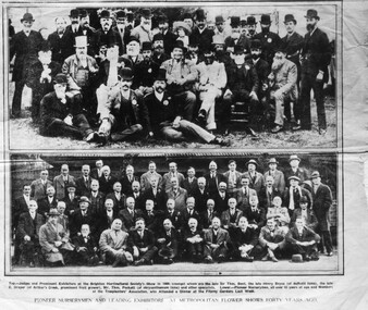
Newspaper - Photograph, Pioneer Nurserymen and Leading Exhibitors at Metropolitan Flower Shows Forty Years Ago, 1929-1930
charles draper, horticultural board of advice, garden show, brighton horticultural society, nurserymen, exhibitors, judges, burnley school of horticulture -
Bialik College
Photograph (Item) - Class Photograph set Year 7 2015
Printed in colour in 2015, digitised in 2023 for reunion scheduled in 2025 Please contact [email protected] to request access to this record. school photograph, class photograph, photograph, bialik, secondary college, 2000s, 2010s -
Bialik College
Photograph (Item) - Class photograph set Year 8 2016
Printed in 2016, digitised in 2023 for school reunion scheduled in 2025. Please contact [email protected] to request access to this record. school photograph, class photographs, bialik, secondary college, 2000s, 2010s -
Bialik College
Photograph (Item) - Class photograph set Year 9 2017
Printed in colour 2017, digitised in 2023 for scheduled reunion in 2025. Please contact [email protected] to request access to this record. photographs, secondary college, bialik, 2000s, 2010 -
Bialik College
Photograph (Item) - Class photograph set Year 10 2018
Printed in 2019, digitised in 2023 for the 2020 graduating class reunion scheduled for 2025 Please contact [email protected] to request access to this record. class photograph, year 10, bialik, secondary college -
 Bendigo Military Museum
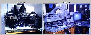
Photograph - AUTOMAP 2 Production - Army Survey Regiment, Fortuna, Bendigo, c1986
This collection of 23 photos of map production on the AUTOMAP 2 computer-based system in Air Survey and Cartographic Squadrons, was most likely taken in 1986. The AUTOMAP 2 system was an upgrade to the AUTOMAP 1 system, comprising Intergraph graphic edit workstation terminals networked to VAX 750/785 main frame computers. Unlike AUTOMAP 1, operators could display digital topographic features on monitors for editing. Successful adaptation of this system meant RASvy was at the forefront of digital mapping/cartographic systems in Australia and overseas. The system comprised Input (Wild B8 Aviograph feature extraction) Raster Scanning (digitising from compilation sheets, Graphic Edit (cartographic completion) and Plot Verification Sub Systems. The system was operational from 1984 to its ‘Newheart’ upgrade in 1993. Throughout its life, the system was progressively refined with productivity gains, achieved from award winning technical development in-house by talented and innovative Army Survey Regiment personnel.This is a set of 23 photograph of AUTOMAP 2 production at the Army Survey Regiment at Fortuna, Bendigo, c1986. The photographs were on 35mm colour slides and were scanned at 96 dpi. Photos .5P and .6P are also printed on photographic and scanned at 300 dpi. They are part of the Army Survey Regiment’s Collection. .1) - Photo, colour, c1986, AUTOMAP 2 Production - Army Survey Regiment, Fortuna, Bendigo. c1986. .2) - Photo, colour, c1986, AUTOMAP 2 Wild B8 Aviograph stereoplotter. .3) - Photo, colour, c1986, AUTOMAP 2 Wild B8 Aviograph stereoplotter feature extraction, unidentified technician. .4) - Photo, colour, c1986, Wild B8 Aviograph stereoplotter feature extraction, LCPL Raelene (Munting) Brodie. .5) - Photo, colour, c1986, AUTOMAP 2 computer tape maintenance, SPR Steve Linane. .6) - Photo, colour, c1986, AUTOMAP 2 Graphic Edit Workstation, SPR Steve Linane. .7) to .8) - Photo, colour, c1986, AUTOMAP 2 Graphic Edit Workstation, unidentified technician. .9 to .10) - Photo, colour, c1986, AUTOMAP 2 Graphic Edit Workstation. .11) - Photo, colour, c1986, AUTOMAP 2 Graphic Edit Workstation feature coding and command menu. .12) - Photo, colour, c1986, AUTOMAP 2 high resolution computer monitor. .13) to .16) - Photo, colour, c1986, AUTOMAP 2 production output comparison to AUTOMAP 1. .17) to .18) - Photo, colour, c1986, AUTOMAP 2 computer system components. .19) - Photo, colour, c1986, AUTOMAP 2 Intergraph 7596 verification plotter. .20) - Photo, colour, c1986, AUTOMAP 2 Benson verification plotter, SPR Steve Coulson. .21) - Photo, colour, c1986, AUTOMAP 2 drainage, contour, roads and cultural digital data verification plot. .22) - Photo, colour, c1986, AUTOMAP 2 drainage, contour, roads and cultural digital data on computer monitor. .23) - Photo, colour, c1986, AUTOMAP 2 3D digital terrain model on computer monitor. .1P to .23P - Some of the equipment is annotated on the frame of the 35mm slides. .5P & .6P prints annotated incorrectly ‘Steve Lenane’. Correct spelling is - ‘Steve Linane’ royal australian survey corps, rasvy, army survey regiment, army svy regt, fortuna, asr, automap 2 -
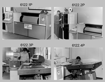
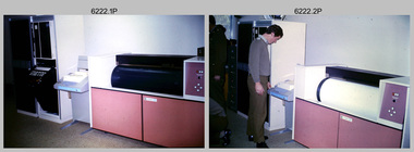 Bendigo Military Museum
Photograph - AUTOMAP 1 Production – Army Survey Regiment, Fortuna, Bendigo, c1978-1980
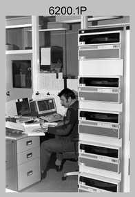
This collection of 17 photos was most likely taken in c1978-1980. The AUTOMAP 1 computer assisted cartography and mapping system was introduced in 1975. The components of AUTOMAP 1 were the Input Sub-System of four Wild B8s stereoplotters and three Gradicon digitising tables, the Optical Line Following Sub-System – Gerber OLF, the Verification Sub-System – Gerber 1442 drum plotter, the General Purpose Sub-system – HP21MX computer and the Output Sub-System – Gerber 1232 flatbed plotter). The first map was published in 1978 (Strickland 3665-3, 1:50,000). AUTOMAP 1 was the first computer assisted cartography and mapping system utilised by the Survey Corps and was the first system used by Australian mapping organisations. The history of the AUTOMAP 1 system is covered in more detail with additional historic photographs, in pages 116-118 of Valerie Lovejoy’s book 'Mapmakers of Fortuna – A history of the Army Survey Regiment’ ISBN: 0-646-42120-4. See items 6122.20P, 6410.24P, 6183.19P, 6184.20P, and 6200.5P for additional photographs of the AUTOMAP 1 system.This is a set of 17 photographs of Air Survey Squadron military and civilian personnel operating AUTOMAP 1 equipment at the Army Survey Regiment at Fortuna, Bendigo, c1978-1980. The photographs were on 35mm colour slides and were scanned at 96 dpi. They are part of the Army Survey Regiment’s Collection. .1) - Photo, colour, c1978-1980, Gerber 1442 verification drum plotter. .2) - Photo, colour, c1978-1980, Gerber 1442 verification drum plotter, SPR Garry Ames. In background - Hewlett Packard (HP) 2100A Minicomputer Input Subsystem controlling Wild B8 Aviograph stereo plotters. .3) - Photo, colour, c1978-1980, Gerber 1442 verification drum plotter. .4) - Photo, colour, c1978-1980, digitising topographic features with a Wild B8 Aviograph stereo plotter, CPL Adrian Rynberk. .5) to .6) - Photo, colour, c1978-1980, Wild PEB8 stereo profiler. .7) - Photo, colour, c1980, HP 9640A Programming System. .8) - Photo, colour, c1980, HP 9640A Programming System, L to R: unidentified, SGT Alan Toogood. .9) - Photo, colour, c1978-1980, Gerber Optical Line Follow (OLF), CAPT Rob Bridge. .10) - Photo, colour, c1978-1980, Gerber OLF. .11.) to .12) - Photo, colour, c1978-1980, Gerber OLF, SPR Gerry Gunn. .13) - Photo, colour, c1978-1980, Gerber OLF. .14) - Photo, colour, c1979, Gradicon edit table. .15) to .16) - Photo, colour, c1981, Gradicon edit table, SPR Chris Gordon. .17) - Photo, colour, c1981, Gradicon edit table, L to R: SPR Chris Brown, unidentified..1P to .17P - Some of the equipment is annotated on the frame of the 35mm slides.royal australian survey corps, rasvy, army survey regiment, army svy regt, fortuna, asr, automap 1 -
 Bendigo Military Museum
photograph - AUTOMAP 1 Production – Army Survey Regiment, Fortuna, Bendigo, c1980
This collection of 20 photos was most likely taken in 1980. The AUTOMAP 1 computer assisted cartography and mapping system was introduced in 1975. The components of AUTOMAP 1 were the Input Sub-System of four Wild B8s stereoplotters and three Gradicon digitising tables, the Optical Line Following Sub-System – Gerber OLF, the Verification Sub-System – Gerber 1442 drum plotter, the General Purpose Sub-system – HP21MX computer and the Output Sub-System – Gerber 1232 flatbed plotter). The first map was published in 1978 (Strickland 3665-3, 1:50,000). AUTOMAP 1 was the first computer assisted cartography and mapping system utilised by the Survey Corps and was the first system used by Australian mapping organisations. The history of the AUTOMAP 1 system is covered in more detail with additional historic photographs, in pages 116-118 of Valerie Lovejoy’s book 'Mapmakers of Fortuna – A history of the Army Survey Regiment’ ISBN: 0-646-42120-4. See items 6410.24P, 6183.19P, 6184.20P, 6200.5P, and 6222.17P for additional photographs of the AUTOMAP 1 system.This is a set of 20 photographs of Air Survey Squadron military and civilian personnel operating AUTOMAP 1 equipment at the Army Survey Regiment at Fortuna, Bendigo, c1980. The photographs were on 35mm negative film and were scanned at 96 dpi. They are part of the Army Survey Regiment’s Collection. Photos .19P and .20P are printed on photographic and scanned at 300 dpi. .1) - Photo, black & white, c1980, Gerber plotter. .2) - Photo, black & white, c1980, Gerber plotter, LT Rob John .3) - Photo, black & white, c1980, Gradicon edit table, SPR Jamie McRae .4) - Photo, black & white, c1980, Gradicon edit table, SPR Steve Linane .5) - Photo, black & white, c1980, 1130 System administration, unidentified. .6) - Photo, black & white, c1980, Wild B8 stereo plotter, SPR Van Dalen? .7) - Photo, black & white, c1980, Wild B8 stereo plotter, SPR Van Dalen? .8) - Photo, black & white, c1980, Gerber Optical Line Follower (OLF). .9) - Photo, black & white, c1980, Gerber OLF. .10) - Photo, black & white, c1980, Gerber OLF. .11) - Photo, black & white, c1980, Gerber OLF. .12) - Photo, black & white, c1980, Gerber OLF. .13) - Photo, black & white, c1980, Data management, CPL Greg Gilbert. .14) - Photo, black & white, c1980, Data management, CPL Greg Gilbert. .15) - Photo, black & white, c1980, 1130 Operating System administration, SGT Denis Marshall. .16) - Photo, black & white, c1980, Programming System, L to R: unidentified, SGT Alan Toogood. .17) - Photo, black & white, c1980, Programming System, L to R: Robert Cox, WO1 Bob Mason, John Dean. .18) - Photo, black & white, c1980, Programming System, L to R: Robert Cox, WO1 Bob Mason, John Dean. .19) - Photo, black & white, c1980, Gradicon edit table, CPL Chris Carter. .20) - Photo, black & white, c1980, Gerber plotter, LT Rob John..1P to .18P - No personnel are identified .19P - ‘CPL Chris Carter’ annotated on backroyal australian survey corps, rasvy, army survey regiment, army svy regt, fortuna, asr, air survey, automap -
 Bendigo Military Museum
Photograph - AUTOMAP 1 Production – Army Survey Regiment, Fortuna, Bendigo, c1979
This collection of 19 photos was most likely taken in 1980. The AUTOMAP 1 computer assisted cartography and mapping system was introduced in 1975. The components of AUTOMAP 1 were the Input Sub-System of four Wild B8s stereoplotters and three Gradicon digitising tables, the Optical Line Following Sub-System – Gerber OLF, the Verification Sub-System – Gerber 1442 drum plotter, the General Purpose Sub-system – HP21MX computer and the Output Sub-System – Gerber 1232 flatbed plotter). The first map was published in 1978 (Strickland 3665-3, 1:50,000). AUTOMAP 1 was the first computer assisted cartography and mapping system utilised by the Survey Corps and was the first system used by Australian mapping organisations. The history of the AUTOMAP 1 system is covered in more detail with additional historic photographs, in pages 116-118 of Valerie Lovejoy’s book 'Mapmakers of Fortuna – A history of the Army Survey Regiment’ ISBN: 0-646-42120-4. See items 6122.20P, 6410.24P, 6184.20P, 6200.5P, and 6222.17P for additional photographs of the AUTOMAP 1 system.This is a set of 19 photographs of Air Survey Squadron military and civilian personnel operating AUTOMAP 1 equipment at the Army Survey Regiment at Fortuna, Bendigo, c1979. The photographs were on 35mm negative film and were scanned at 96 dpi. They are part of the Army Survey Regiment’s Collection. .1) - Photo, colour, c1979, Gradicon edit table, SSGT John Bennett. .2) - Photo, colour, c1979, Gradicon edit table. .3) - Photo, colour, c1979, HP21MX computer General Purpose Sub-system. .4) - Photo, colour, c1979, HP21MX computer General Purpose Sub-system. L to R: CAPT Graham Baker, SPR Ian Belmont. .5) - Photo, colour, c1979, Gerber verification drum plotter. 1130 System administration, unidentified. .6) - Photo, colour, c1979, Gerber Optical Line Follower (OLF). .7) - Photo, colour, c1979, Gerber OLF .8) - Photo, black & white, c1979, Programming and system administration, L to R: WO1 Don Taylor, Robert Cox, Tony Spurling, SSGT John Bennett, SGT Alan Toogood. .9) to .14) - Photo, black & white, c1979, .15) - Photo, black & white, c1979, Gerber OLF, unidentified. .16) - Photo, black & white, c1979, Gerber verification drum plotter, unidentified using Gradicon edit table. .17) to .18) - Photo, black & white, c1979, - Photo, black & white, c1979, Programming and system administration, SSGT John Bennett. .19)- Photo, black & white, c1979, - Photo, black & white, c1979, HP21MX computer General Purpose Sub-system..1P to .19P No personnel are identified.royal australian survey corps, rasvy, army survey regiment, army svy regt, fortuna, asr, automap 1 -
 Bendigo Military Museum
Photograph - AUTOMAP 1 Production – Army Survey Regiment, Fortuna, Bendigo, c1980
This collection of five photos was most likely taken in c1980. The AUTOMAP 1 computer assisted cartography and mapping system was introduced in 1975. The components of AUTOMAP 1 were the Input Sub-System of four Wild B8s stereoplotters and three Gradicon digitising tables, the Optical Line Following Sub-System – Gerber OLF, the Verification Sub-System – Gerber 1442 drum plotter, the General Purpose Sub-system – HP21MX computer and the Output Sub-System – Gerber 1232 flatbed plotter). The first map was published in 1978 (Strickland 3665-3, 1:50,000). AUTOMAP 1 was the first computer assisted cartography and mapping system utilised by the Survey Corps and was the first system used by Australian mapping organisations. The history of the AUTOMAP 1 system is covered in more detail with additional historic photographs, in pages 116-118 of Valerie Lovejoy’s book 'Mapmakers of Fortuna – A history of the Army Survey Regiment’ ISBN: 0-646-42120-4. See items 6410.24P, 6122.20P, 6183.19P, 6184.20P and 6222.17P for more photos of the AUTOMAP 1 computer system.This is a set of five photographs of Air Survey Squadron military personnel operating AUTOMAP 1 equipment at the Army Survey Regiment at Fortuna, Bendigo, c1980. Black and white photos are on photographic paper and were scanned at 300 dpi. They are part of the Army Survey Regiment’s Collection. .1) - Photo, black & white, c1980, SGT Cliff Webb operating AUTOMAP 1 terminal. .2) - Photo, black & white, c1980, HP21MX computer General Purpose Sub-system. .3) - Photo, black & white, c1980, Gerber verification drum plotter. .4) and .5) - Photo, black & white, c1980, unidentified personnel operating AUTOMAP 1 terminal. .1P to .5P - No personnel are identified.royal australian survey corps, rasvy, army survey regiment, army svy regt, fortuna, asr, automap 1 -
 Eltham District Historical Society Inc
Audio - Audio Recording, AGM and Peter Pidgeon - Recent additions to the collection, 15 Apr. 2023
EDHS Newsletter No. 269 April 2023 At this meeting we are pleased to have Peter Pidgeon, our vice president, as our speaker to talk about a selection of photographs recently added to our collection. Peter, who is our Digital Collections, Website and Social Media Manager, has scanned and catalogued much of the content on our Victorian Collections website and maintains our website, facebook and social media. The focus of his presentation will be on new additions to the collection, records of interest that have been digitised over the past year and added to Victorian Collections and the processes we undertake.1:26:31 duration Digital MP3 file; 29.7MBaudio recording, eltham district historical society, meeting, society meeting, eltham, activities, catalogue, collections team, peter pidgeon, victorian collections -
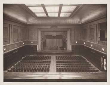
 Glen Eira City Council History and Heritage Collection
Photograph
One of 5 B/W photographs showing areas within Caulfield Town Hall. Production date unknown sometime after 1931 and before 1976. Copyright for this image is unknown, although likely commissioned by Council. It has been digitised and published here for educational and research purposes. If you believe that you have copyright to this image and would like it removed from the site please contact us through the 'Leave a Comment' tab below.B/W photograph showing the rear balcony, ceiling and seating in the Auditorium in the Glen Eira Town Hall. The image shows the Caulfield Town Hall Auditorium prior to 1987 when it was reconstructed and divided to make a lower floor to accommodate a gallery and an auditorium on the floor above.Small Sticker, green and gold, adhered to r.h.s. verso corner 'The Speciality Press Pty. Ltd.' -
 Glen Eira City Council History and Heritage Collection
Photograph
One of 5 B/W photographs showing areas within Caulfield Town Hall. Production date unknown, sometime after 1931 and before 1976. Original source unknown. Copyright for this image is unknown, although likely commissioned by Council. It has been digitised and published here for educational and research purposes. If you believe that you have copyright to this image and would like it removed from the site please contact us through the 'Leave a Comment' tab below.B/W photograph showing the main hall, Caulfield Town Hall, including the seating facing towards the stage set up with a table, chairs and a piano. The image shows the Caulfield Town Hall Auditorium prior to 1987 when it was reconstructed and divided to make a lower floor to accommodate a gallery and an auditorium on the floor above.Small Sticker, green and gold, adhered to r.h.s. verso corner 'The Speciality Press Pty. Ltd.' -
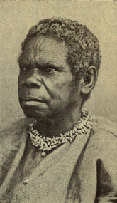 Federation University Historical Collection
Photograph - Image, Truganini
Digitised directly from 'Blackfellows of Australia' by Charles Barrett and A.S. Kenyon (Sun Books)Aboriginal woman named Truganini wearing a shell necklace. She was a native of Bruni Island, Tasmania. Title - Truganini (When She Died Her Race Became Extinct).aborigine, aboriginal, truganini, tasmania, bruni island, shell necklace -
 Greensborough Historical Society
Mixed media - Folder containing photographs and disc, Family photos of Chapman and Stock families, 1860o
A collection of photos of the Chapman and Stock families of Greensborough and Lower Plenty.Photos and letters have been digitised by Peter Blackbourn as part of his family history research.Compact Disc. Contains 95 images of Chapman, Stock, Blackbourn and Barnett families dating from late 19th century through the 20th century. Also printed copies of photographs.Greensborough and Lower Plenty photos from Chapman and Stock familiespeter blackbourn, chapman family, stock family lower plenty, chapman stock family -
Moorabbin Air Museum
Photograph (item) - (SP) 31 Squadron Various Photos and documents digitised - Squadron Leader John Madden
Moratai, Beaufighter Battle photos, Coomalie historical photos, Beaufighter photos and documents See some files under Media - Rest of files on SP -
 Bendigo Military Museum
Photograph - AUTOMAP 1 Production – Army Survey Regiment, Fortuna, Bendigo, c1978-1980
This collection of 20 photos was most likely taken in c1978. The AUTOMAP 1 computer assisted cartography and mapping system was introduced in 1975. The components of AUTOMAP 1 were the Input Sub-System of four Wild B8s stereoplotters and three Gradicon digitising tables, the Optical Line Following Sub-System – Gerber OLF, the Verification Sub-System – Gerber 1442 drum plotter, the General Purpose Sub-system – HP21MX computer and the Output Sub-System – Gerber 1232 flatbed plotter). The first map was published in 1978 (Strickland 3665-3, 1:50,000). AUTOMAP 1 was the first computer assisted cartography and mapping system utilised by the Survey Corps and was the first system used by Australian mapping organisations. The history of the AUTOMAP 1 system is covered in more detail with additional historic photographs, in pages 116-118 of Valerie Lovejoy’s book 'Mapmakers of Fortuna – A history of the Army Survey Regiment’ ISBN: 0-646-42120-4. See items 6122.20P, 6410.24P, 6183.19P, 6200.5P, and 6222.17P for additional photographs of the AUTOMAP 1 system.This is a set of 20 photographs of Air Survey Squadron military and civilian personnel operating AUTOMAP 1 equipment at the Army Survey Regiment at Fortuna, Bendigo, c1978-1980. Black and white photos .1P to .18P are on photographic paper and were scanned at 300 dpi. Photo .4P is in colour and mounted with a duplicate on manilla card. Black and white photos .19P to .20P are on 35mm negative film and scanned at 96 dpi.They are part of the Army Survey Regiment’s Collection. .1) - Photo, black & white, c1978-1980, Gerber Optical Line Follower (OLF), SSGT John Bennett. .2) - Photo, black & white, c1978-1980, HP21MX computer General Purpose Sub-system. .3) - Photo, black & white, c1978-1980, Gerber OLF .4) - Photo, colour, c1978-1980, unidentified digitising on Gradicon edit table. .5) - Photo, black & white, c1978-1980, Gerber verification drum plotter. .6) - Photo, black & white, c1978-1980, Gerber OLF, CAPT Rob Bridge. .7) - Photo, black & white, c1978-1980, Programming and system administration, SGT Alan Toogood. .8) - Photo, black & white, c1978-1980, Unidentified digitising on Gradicon edit table. .9) - Photo, black & white, c1978-1980, CPL Rick Downie digitising on Gradicon edit table. .10) - Photo, black & white, c1978-1980, SPR Dave Irving digitising on Gradicon edit table. .11) - Photo, black & white, c1978-1980, Gerber OLF and CPL Rick Downie. .12) - Photo, black & white, c1978-1980, 1130 Computer System administration, L to R: unidentified, SSGT Les Dixon, SPR Geoff Havelberg. .13) - Photo, black & white, c1978-1980, AUTOMAP 1 tape administration, Maryanne De Groot. .14) - Photo, black & white, c1978-1980, AUTOMAP 1 tape drive. .15) - Photo, black & white, c1978-1980, HP21MX computer General Purpose Sub-system. .16) - Photo, black & white, c1978-1980, digitising topographic features with a Wild B8 stereo plotter, L to R: unidentified, CPL John Smith. .17) - Photo, black & white, c1978-1980, digitising topographic features with a Wild B8 stereo plotter, CPL John Smith. .18) - Photo, black & white, c1978-1980, digitising topographic features with a Wild B8 stereo plotter, CPL Adrian Rynberk. .19) - Photo, black & white, c1978-1980, Programming and system administration, SGT Alan Toogood. .20) - Photo, black & white, c1978-1980, Gerber OLF, CPL Chris Edwards. .1P to .20P - No personnel are identified.royal australian survey corps, rasvy, army survey regiment, army svy regt, fortuna, asr, automap 1 -
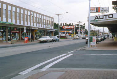 Glen Eira Historical Society
Album - Page 13 of folder D-F, Caulfield Municipality Photo Slide Collection, c.1976 - c.1994
The photographs for the slides are believed to have been taken by the inaugural Editor for the Caulfield Contact - the official newspaper of the former City of Caulfield from 1976-1994. The Editor was also Council's Community Liaison Officer and she (and her successor) took many photographs of official events and Council-related services and locations in connection with both these official roles. The City of Caulfield was the Municipal Council for an area of the South Eastern suburbs of Melbourne, including Brighton East, Carnegie, Caulfield, Elsternwick, Gardenvale, Glen Huntly, McKinnon, Murrumbeena, Ormond and St Kilda East. Credit: Glen Eira Historical Society - This item was digitised and made available through the Glen Eira Heritage Digitisation Strategy 2019-2023. Glen Eira Historical Society acknowledges the support of Glen Eira City Council. Page 13 of slide album D to F, in a polypropylene slide sleeve containing 12 x 35mm colour slides. A sample of 2 images from this page is included. glen eira city council, local government, caulfield city council, caulfield council, city of caulfield, caulfield contact, elsternwick, caulfield municipality photo slide collection, roads and streets, parking, shops, downshire road, glenhuntly road, trams, hopetoun gardens, parks and reserves, cannons -
University of Melbourne, Burnley Campus Archives
Photograph - Colour print, Kodak, Construction of Timber Bench & Table, Unknown
7 colour photographs showing construction of timber bench and table. Not at Burnley Campus. Not digitised.construction, timber bench, table, woodwork -
University of Melbourne, Burnley Campus Archives
Slide - Colour slides, Kodachrome, Plant Identification, Unknown
60 col;our slides of plants, flowers and trees, some labelled. Photographs not taken at Burnley. Not digitised.plant identification, plants, flowers, trees, plant id -
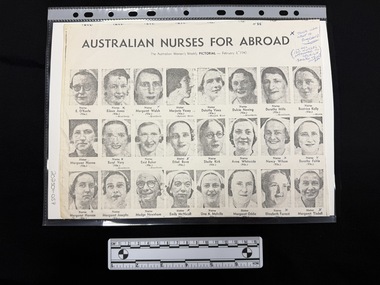 Returned Nurses RSL Sub-branch
Document - Photocopy of a magazine clipping, The Australian Women's Weekly Pictorial, Australian Nurses for abroad, February 3, 1940
Images of Australian nurses about to embark for WWII February 1940. [As there is no digitisation of this magazine (The Australian Women's Weekly Pictorial) this photocopy of the clipping is important.][Publication not found in digitised format]Black and white photocopy of a magazine page featuring head shot photographs of women in nursing uniforms, their names captioned under each one. There are also handwritten annotations.'H88' [blue ink at the top on the right hand side] 'X THOSE WHO / WENT TO / ENGLAND / (IN ALL / 120 NURSES / ATTACHED TO / 2/2A.GH / SAILED TO / MIDDLE / EAST)' [blue ink on at the top right hand side] [10 captions under the photographs marked with a blue inked X]wwii, world war two, ww2, australian nurses -
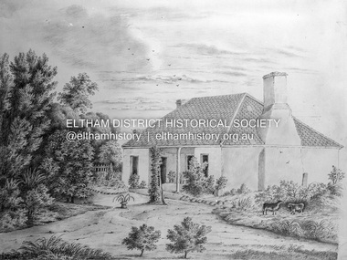 Eltham District Historical Society Inc
Negative - Photograph, Charles Bertie, Sketch; Sweeney's Cottage, Culla Hill, Eltham (n.d.), c.1905
In the early 1900s, Mary Sweeney commissioned artist Charles Bertie to paint the main house at Culla Hill. He charged her 5 shillings for the picture and 18 pence for the frame She took this painting with her when she married Michael Carrucan in 1910 and it hung in the Dalton Street farmhouse for many years. At a later time (1960s), the Burstons (the then owners of Culla Hill) had a card printed from the painting. The original sketch was photographed in 1970 for reproduction in the Shire history publication Pioneers & Painters (1971). The very fragile original was kept in the Council strongroom and suffered significant damage to its edges over the years, no doubt it has also yellowed. A comparison of the original as digitised (2022) with the negative taken 50 years earlier also reveals that the left 20% of the sketch has been cut off, probably due to damage. In June 1842 Thomas Sweeney applied to the Superintendent, C.J. La Trobe, asking permission to purchase a portion of the recently surveyed ‘Parish of Nillumbik'. His request was allowed and handed to the sub-treasurer and Land Board. He paid £110 for 110 acres and called the land 'Culla Hill'. He first built a temporary house, a slab hut 12 feet by 10 feet, in which he lived with his wife, an Irish girl whom he had married in 1838. (His first wife had been drowned at Port Jackson.) Some time later he built a permanent residence on the model of a Tipperary farmhouse. It was a rectangular building of hand-made bricks and stone quarried from the Western Hill with a recessed verandah in front, and bore a slate roof. The out-buildings consisted of a detached kitchen, stable and a barn. It was in this house that succeeding generations of Sweeneys were reared. The original slab hut became a washhouse and survived till recent years. 'Culla Hill' became a social centre for the district, church services being held there on various occasions. The first wheat crop in the district was planted by Sweeney who also supplied the first grain for a mill that later was built at Eltham. He took an active interest in the development of the district. At this time travelling people--many of them runaway sailors or convicts--often passed the settlement, and some of them stayed and worked with Sweeney. A tribe of aborigines living on the river below 'Culla Hill' were apparently on good terms with Sweeney, for it is said that they helped him with the building of his house. Very little is known about the aborigines who originally lived in the Eltham district. There must have been many of them; their stone axes, grinding stones, and anvil stones have been found in the gullies around Research and canoe trees and artifacts were found on the Kangaroo Ground hills. Early settlers remembered a tribe that camped on the site of the present railway bridge at Eltham. They held corroborees there and visited settlers for hand-outs of 'flour and bacca’. There was an aboriginal reserve on the Yarra, upstream from Eltham, but most of those who had collected there later went to live on the Pound Reserve at Warrandyte, where the last aborigines in the area finally ended their days. The Pound Reserve, of 1,103 acres, was established at Pound Bend in 1841. The chief protector, George Robinson, and his four assistants, were given instructions to care for the aged and sick, to provide blankets and rations for all who lived there, to train the able-bodied men in agriculture and other trades and to find them jobs. The Yarra blacks, who later came under the protection of William Thomas, have been described as a 'fine race, well made and above the average height'. Thomas Sweeney died on 6 September 1867 and was buried in the Eltham Cemetery. To his wife Margaret and his son John, he left the entire property of 'Culla Hill'. To his other son Patrick, he left 150 acres, including a small two-roomed wooden cottage. He had five daughters: Kate and Margaret (twins) who were born in 1842, Ellen 1846, Annie 1848 and Johanna 1851. John Sweeney farmed 'Culla Hill' until his death in 1909. He had ten children; one of them, Mary, became Mrs M. Carrucan whose son, Mr John Carrucan, still lives at Eltham. 'Culla Hill' passed out of the Sweeneys possession in 1939 and was renamed by its new owners, 'Sweeneys', in memory of its pioneers. - Pioneers & Painters: One Hundred Years of Eltham and its Shire, Alan Marshall 1971, pp10-12 Original colour sketch artwork 4 x 5 inch black and white negative of original colour sketchculla hill, art, charles bertie, drawing, mary carrucan (nee sweeney), sketches, sweeney's cottage -
University of Melbourne, Burnley Campus Archives
Photograph - Black and white prints, Gilbert Chandler Campus Dairy Factory, c. 1991
19 black and white photographs in photograph folder students and an instructor (Dean Wilkins) making cheese. . Possibly an excursion to the Gilbert Chandler Campus Dairy Factory. Not digitised.Labelled, "odd shots of Dean Wilkins and students at G. Ch." Many very similardean wilkins, students, gilbert chandler campus, dairy factory, cheese making, excursion -
University of Melbourne, Burnley Campus Archives
Photograph - Colour prints and negatives, Vege Field Day, 1991
... , "Vege Field Day May 2-3 1991." 19 colour photographs ...19 colour photographs in photograph folder Most very similar. They don't look like Burnley students. Possibly an excursion. Not digitised.Labelled, "Vege Field Day May 2-3 1991." vegetables field day, school students, excursion -
University of Melbourne, Burnley Campus Archives
Photograph - Colour prints, P. Kenyon, Plant Materials, Unknown
... . Labelled. Not digitised. Plant Materials Photograph Colour prints P ...16 colour photographs of native flowering plants. Probably used for Plant ID. Labelled. Not digitised.plants, native plants, flowering plants, plant id