Showing 3022 items
matching division
-
 Ringwood RSL Sub-Branch
Medal - L/Bomb. J.E.Ryan, 4th Division Ammunition Column
-
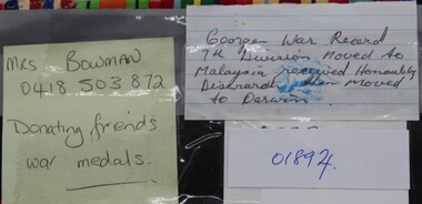 Ringwood RSL Sub-Branch
Medal - George's War medals, 7th division
-
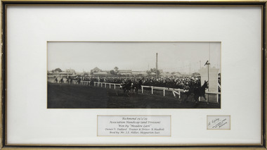 Victorian Harness Racing Heritage Collection at Lord's Raceway Bendigo
Photograph - Wooden framed photo finish, Meadow Lark. 25/2/1929 - Association Handicap (2nd Division), Owner V Dullard, Trainer and Driver R.Shadbolt. Bred by MrJ.F.Hillier, Shepparton East
trotting, richmond, vic dullard, joe hillier, meadow lark, shepparton, 25/2/1929 -
Moorabbin Air Museum
Book - Quantas Empire Airways (Western Operations Division) Indian Ocean Service 1943-1946, Barry Pattison et al
This book covers the story of the air route from Australia to India across the Indian ocean that was established after traditional methods of communication and transport had been cut with the fall of Singapore.Tan cover with black text and a monochrome photo of a docked sea plane.This book covers the story of the air route from Australia to India across the Indian ocean that was established after traditional methods of communication and transport had been cut with the fall of Singapore.ww2, qantas -
 Ringwood and District Historical Society
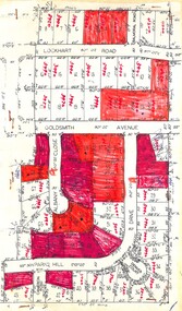
Plan, Residential Land Sale Sub-division
Subdivision map of 60 residential allotments for sale in North Ringwood, Vic., circa 1968, with handwritten asking price annotations. Subdivision includes Lockhart Road, Goldsmith Avenue, Albany Close and Park Hill Drive. -
 Victorian Railway History Library
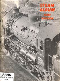
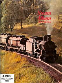
Book, The New South Wales Rail Transport Museum, Steam Album First Division, 1968
Pictures of steam locomotives in New South Wales.ill, p.56.non-fictionPictures of steam locomotives in New South Wales.steam locomotives - australia - history, railroad steam locomotives - new south wales - history -
 Victorian Railway History Library
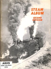
Book, The New South Wales Rail Transport Museum, Steam Album Second Division, 1969
Pictures of steam locomotives in New South Wales.ill, p.56.non-fictionPictures of steam locomotives in New South Wales.steam locomotives - australia - history, railroad steam locomotives - new south wales - history -
 Victorian Railway History Library
Book, The New South Wales Rail Transport Museum, Steam Album Third Division, 1973
Pictures of steam locomotives in New South Wales.ill, p.56.non-fictionPictures of steam locomotives in New South Wales.steam locomotives - australia - history, railroad steam locomotives - new south wales - history -
 Heidelberg Golf Club
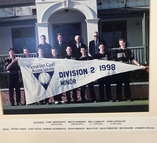
Photograph - Team Photograph, Victorian Golf Association Division 2 1998 Minor, 1998
Group photograph with caption: Back Row: Gary Armstrong (Manager), Bruce Harding (President), Bill Garratt (Vice Captain), John Gonzales (Captain). Front: Peter Cassidy, Luke Young, Robert Gilderdale, Adam Smedley, Rian Gist, Dale Streeter, Ben Fraser, Andrew Spicer.Mounted colour team photograph, with caption golf teams, pennant golf -
 Heidelberg Golf Club
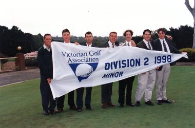
Photograph - Team Photograph, Victorian Golf Association Division 2 1998 Minor, 1998
Group photograph with pennant: Peter Cassidy, Luke Young, Robert Gilderdale, Adam Smedley, Rian Gist, Dale Streeter, Ben Fraser, Andrew Spicer.Colour team photograph golf teams, pennant -
Moorabbin Air Museum
Administrative record (Item) - (SP) CAC History files - Production Programme Factory - File 1 - 24Apr1942 to 18Mar1952, 19431119 Engine Division Project Priorities.pdf
-
Moorabbin Air Museum
Administrative record (Item) - (SP) CAC History files - Production Programme Factory - File 1 - 24Apr1942 to 18Mar1952, 19450911 Engine Division Production Report.pdf
-
Moorabbin Air Museum
Administrative record (Item) - (SP) CAC History files - Production Programme Factory - File 1 - 24Apr1942 to 18Mar1952, 1942 Engine Division Production Programme.pdf
-
 National Vietnam Veterans Museum (NVVM)
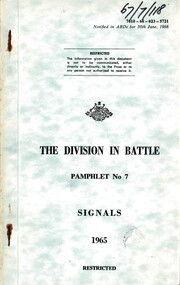
Booklet, Australian Army, Australian Army: The Division in Battle: Pamphlet No. 7: Signals, 1965, 1965
A multicoloured green/cream plastic cover with black information. Top right hand side handwritten in black texta is 67/7/118. Under this reads 7610-66-023-5721. There are two rusty metal staples down the left hand side.australia - armed forces - service manuals, signals -
 National Vietnam Veterans Museum (NVVM)
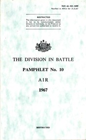
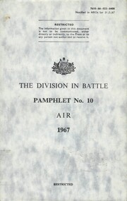
Booklet, Australian Army, Australian Army: The Division in Battle: Pamphlet No. 10: Air, 1967, 1967
A green/cream coloured plastic cover with black informaion on it. Top right hand side reads 7610-66-023-8400. The booklet is held together by two metal screws which are in the inside of the cover.australia - armed forces - service manuals, air -
 National Vietnam Veterans Museum (NVVM)
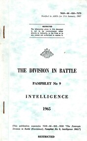
Booklet, Australian Army, Australian Army: The Division in Battle: Pamphlet No. 9: Intelligence, 1965, 1965
A green/cream coloured plastic cover with black informatio. Top right corner reads 7610-66-024-7173. Down he left hand side there are tow rusty metal staples.australia - armed forces - service manuals, intelligence -
 Bendigo Military Museum
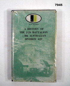
Book - BATTALION HISTORY WW2, 2/29 Battalion AIF Association/1983", "A HISTORY OF THE 2/29 BATTALION - 8th AUSTRALIAN DIVISION AIF", 1983 First Edition
Refer Cat No. 7944. Item in the collection of "Arthur E. Tranter". V50166 - VX52843 2/29th Bn. P.O.W.Hard cover book with dust cover. First Edition Book. Hard cover - cardboard, black colour buckram adhered cover. Dust cover - paper, with black print on front and spine. Cover ilustration - muted green colour tones of a tank and roadblock - "Muar Road Battle". Plastic cover - clear soft plastic - protective cover with adhesive tape. 224 pages, cut, plain white paper. Illustrated with black and white photographs and maps. A number of pages have handwritten notes in grey lead pencil and blue ink pen. P.186 has an added note on paper. Handwritten owner's name front end paper. Page 186 - note on paper, blue ink pen. "P.186/ This section by R.F. Nelson/ describes my experience/ fairly well./ I was with him throughout the whole/ term of imprisonment". Front end paper - handwritten owner's name - blue ink pen "Arthur E. Tranter/ 24-4-83".plublications, book, 2/29 battalion, ww2, arthur e tranter -
Lakes Entrance Historical Society
Book - Manuscript, Cunnnghame, Boyd Alexander, Mary, and Margaret, Commonwealth of Australia Electoral Roll, State of Victoria, Division of Gippsland. Roll of electors who vote at Cunninghame Polling Place, 1900c
Copies of typed transcripts of letters between Boyd and Mary Cunninghame, settlers in Gippsland, and members of the Cunninghame family in Scotland in the mid 19th. Centurysettlers -
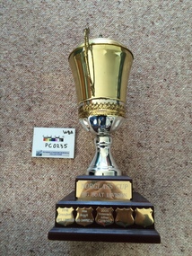 The Paynesville Maritime Museum
Award, Norglass Cup Big Boat Division
trophy, trophies, cup, cups, norglass -
 Greensborough Historical Society
Book - Pamphlet, The Division in battle; pamphlet No 4: Armour, 1965
Australian Army. Royal Australian Armoured Corps. Military Manual.In 4 parts, pages not numbered, Illus.Restricted. Contains classified Australian information.world war i, military manuals, armour, military equipment -
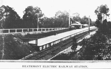 Ringwood and District Historical Society
Photograph, Heathmont Railway Station, 1926. Image taken from a land sale brochure advertising Charm-View Estate Sub-division opposite the station
Black and white photographs (2 copies - same size)Written under photograph - HEATHMONT ELECTRIC RAILWAY STATION. Written on back of photograph, "Photo taken from Sub. Div. Land Sale - Heathmont Electric Railway Station right opposite Estate. Charm-View Estate. Heathmont (For private Sale), 1926?" -
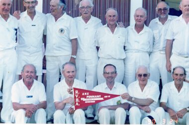 Ringwood and District Historical Society
Photograph, Ringwood Bowls Club - Pennant team, 1989-90. No 6 side, section winners, Division 12
Coloured photograph -
Moorabbin Air Museum
Book - A HISTORY OF EASTERN AIRCRAFT DIVISION, GENERAL MOTORS CORPORATION, 1944
-
Moorabbin Air Museum
Manual - Gulfstream Commander, Pilot's Checklist Commander Division
Pilot checklist for Gulfstream Commander 695B circa 1984Ring binder - 1 ring missingnon-fictionPilot checklist for Gulfstream Commander 695B circa 1984 -
Bendigo Military Museum
Manual - National Research Council of Canada, Division of Applied Physics - Strip triangulation of measured points, National Research Council of Canada, Nov 1961, Dec 1966, Oct 1966, Jan 1967
The Royal Australian Survey Corps, Army Survey Regiment used transformations of Aerial Photographic strip and block coordinates to accurately calculate setup parameters for the extraction of topographical features on Wild B8 stereo plotters. This manual describes the methods and "Fortran" computer programming language solutions. Chapter 1 - Transformation and adjustment of strip coordinates by electronic computation. Chapter 2 - An Introduction to Analytical Strip Triangulation with a "Fortran" program. Chapter 3 - A "Fortran" program for the adjustment of Strips and Blocks by Polynomial Transformations. Chapter 4 - A modified "Fortran" (IBM 1620) program for the adjustments of Strip coordinates.Hard Covered Manual containing Chapter 1 - 8 x pages, Chapter 2 - 84 x pages, Chapter 3 - 33 x pages, Chapter 4 - 29 x pages.Distribution stamps and labels on front cover.royal australian survey corps, rasvy, fortuna, army survey regiment, army svy regt -
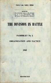 National Vietnam Veterans Museum (NVVM)
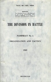
Booklet, Australian Army, Australian Army: The Division In Battle, Pamphlet No. 1: Organization And Tactics, 1965 (Copy 1), 1965
A light blue coloured cardbaord cover with black information on the front. Top of the booklet reads 7610 / 66 / 023 / 4924. The booklet is held together with two metal screws on the inside of the cover.booklet, division in battle, organization and tactics -
 National Vietnam Veterans Museum (NVVM)
Booklet, Australian Army, Australian Army: The Division In Battle, Pamphlet No. 1: Organization And Tactics, 1965 (Copy 2), 1965
A light blue coloured cardbaord cover with black information on the front. Top of the booklet reads 7610 / 66 / 023 / 4924. The booklet is held together with two metal screws on the inside of the cover.booklet, division in battle, organization and tactics -
 National Vietnam Veterans Museum (NVVM)
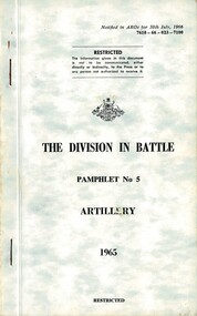
Booklet, Australian Army, Australian Army: The Division In Battle, Pamphlet No. 5: Pamphlet No. 5, Artillery, 1965 (Copy 1), 1965
A light blue cardboard caver with black information on the front. top right hand corner reads 610-66-023-7108. Under the Australian Coat of Arms is the details of the booklet. There is a white label on the left hand bottom with typed information on it. The booklet is covered with a plastic cover and there are two metal staples down the left hand side.booklet, division in battle, artillery -
 National Vietnam Veterans Museum (NVVM)
Booklet, Australian Army, Australian Army: The Division In Battle, Pamphlet No. 5: Pamphlet No. 5, Artillery, 1965 (Copy 2), 1965
A light blue cardboard caver with black information on the front. top right hand corner reads 610-66-023-7108. Under the Australian Coat of Arms is the details of the booklet. There are two metal staples down the left hand side.booklet, division in battle, artillery -
 National Vietnam Veterans Museum (NVVM)
Booklet, Australian Army, Australian Army: The Division In Battle, Pamphlet No. 10: Air, 1967 (Copy 1), 1967
A light blue coloured cover with black information on the front. Top right hand corner reads 7610-66-023-8400. The booklet is held together with metal screws from the inside of the cover. The booklet is covered with a plastic cover.australia - armed forces - service manuals, australian army, division in battle, air, booklet