Showing 1049 items
matching earth
-
 Eltham District Historical Society Inc
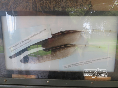
Photograph, Moor-Rul Viewing Platform Panel: Wing tailed feather of the Wedge-tailed Eagle (BUNJIL), 10 August 2016
One of eight double-sided interpretation panels on the Moor-rul viewing platform at the War memoiral park in Kangaroo Ground highlight the area's indigenous history. Wing feathers of the wedge-tailed Eagle (BUNJIL) Courtesy of the Melbourne Museum. "On a clear day a pair of these magnificent birds might be seen soaring high above this platform on rising thermals" For the Wurundjeri people, Bunjil, the Eaglehawk was seen as being the all powerful Being of the Dreamtime, the all-father who created the centre world and its creatures. After the creation Bunjil with his wives and sons went up intothe “tharingbeik”, the sky, where he remains today as the star Attair. Souce: Document compiled by EDHS in 1997 for a series of historic items for Diamond Valley Public Radio. The Moor-Rul Viewing Platform, part of the Kangaroo Ground War Memorial Park opened in April 2007. Eight double-sided interpretation panels on the Moor-rul viewing platform highlight the area's Aboriginal and European history of the area and also details of local geology, flora and fauna. These panels feature high quality graphic design and professionally written text. The subjects covered are: ''Womin Je Ka" Welcome The Kulin Nation Singing, Dancing, Ceremony, Celebration This Country, My Home The Highland Taken Auld Lang Syne "Same Land Different Views" Working the Land Food from the Earth or "Earth's Harvest" Lest We Forget, "And with the going down of the Sun .... (3 panels) This Black Earth Those other indigenous inhabitants - Kangaroo Ground's Wildlife Silent Witnesses - Kangaroo Ground's White Manna Gums Belonging A Place of Reverence and A Tower of Strength Souce: EDHS Newsletter No 173 March 2007. As part of a program to acknowledge the Anzac Centenary Nillumbik Shire Council partnered with Yarra Plenty Regional Library to provide a bus tour with commentary of local sites of significance: Shire of Nillumbik World War One Memorials tour, 10 August 2016. These included Eltham township, the Shire of Eltham War Memorial at Kangaroo Ground, Christmas Hills war memorial, Hurstbridge memorial recreation park and finshed at Eltham Library to view the Writing the War exhibtion at Eltham Library Community Gallery. Born Digitalshire of nillumbik, kangaroo ground, moor-rul viewing platform, interpretative signage, eagle, feather, interpetation panel, dreamtime, bunjil -
 Bendigo Historical Society Inc.
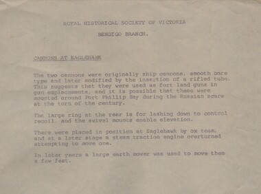
Document - CANNONS AT EAGLEHAWK, c1970?
Document. Cannons at Eaglehawk. Typed document by the Bendigo Branch of the Royal Historical Society of Victoria on the cannons at Eaglehawk. It reads - The two cannons were originally ship cannons, smooth bore type and later modified by the insertion of a rifled tube. This suggests that they were used as fort land guns in gun emplacements, and it is possible that these were mounted around Port Phillip Bay during the Russian scare at the turn of the century. The large ring at the rear is for lashing down to control recoil, and the swivel mounts enable elevation. These were placed in position at Eaglehawk by ox team, and at a later stage a steam traction engine overturned attempting to move one. In later years a large earth mover was used to move them a few feet.cottage, miners, cannons at eaglehawk -
 Bendigo Historical Society Inc.
Document - IAN DYETT COLLECTION: AUCTION CATALOGUE - THE CITY OF GREATER BENDIGO
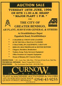
Bright yellow auction catalogue with black printing for a sale on 18th June, 1996 for the City of Greater Bendigo, AH Plant, Surveyor General & Others at Strathfieldsaye Depot, Strathfieldsaye. For sale were Earth moving equipment, tractors, 3 P/L equipment, caravans, various mowers, chippers,shredders, brush cutters, trailers, scrap, tools, Surveyors equipment, office furniture & computer equipment, drums of bitumen and R/C concrete drains. J. H. Curnow & Son P/L were the auctioneers. Map of how to get to auction site inside front cover. Loose pink Supplementary List, account Coliban Water listing backhoe/F.E. loaders, tractor, tipper crane and 4WD wagon listed.business, auctioneers, j h curnow & son pty ltd, ian dyett collection - auction catalogue - the city of greater bendigo, ah plant, surveyor general & others, darryl young, ian dyett, j h curnow & son p/l, coliban water, noel dyett, fred dyett -
 The Beechworth Burke Museum
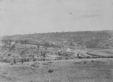
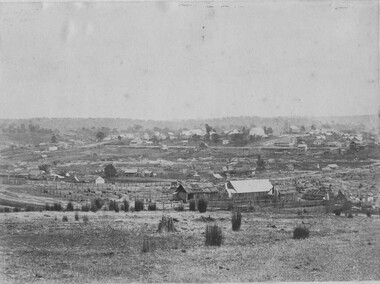
Photograph, c1865
This was taken in 1865 of Spring Creek, Beechworth. Gold was discovered in this area in 1852 and within eleven months of this discovery, over 8000 hopeful prospectors had descended on the region, transforming the seemingly undisturbed land into what a visiting journalist in 1880s referred to as; "A Titan's Field". Huge mounds of earth were churned by hundreds of miners in search for gold, almost every available resource the land had to offer was used for something; even the bark off the gums were stripped to line huts and shafts. By 1857 more than 20,000 people lived in Beechworth, and with this influx the town prospered with the building of numerous churches, banks, schools, shops and hotels along with a prison and hospital.Black and white rectangular photograph. Image is printed on matte photographic paper and is mounted on cardboard. Obverse: NO INSCRIPTION Revese: 97.22.95 / 7772 / 25/1 / beechworth, burke museum, gold rush, 1865 -
 Warrnambool and District Historical Society Inc.
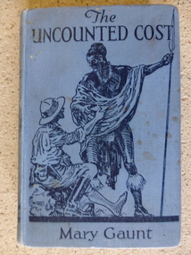
Book, The Uncounted Cost by Mary Gaunt, 1925
The Uncounted Cost is one of a number of works written by Mary Gaunt. Her other works include, Alone in West Africa, A Woman in China, The End of the Earth, Kirkhams Find, The Moving Finger and Deadman’s. Mary was born at Indigo near Chiltern in 1862 and lived for many years in Ballarat where her father W.H. Gaunt was gold commissioner and later a judge. The original Gaunt family home was converted into St Patrick’s College. She married Dr Lindsay Miller and moved to Warrnambool and after his death in 1899 she embarked on her travels which took her to many parts of the world. She died in Cannes, France in January 1942.Mary Gaunt wrote over 25 novels, numerous travel books and many stories and articles. She had a strong link with Warrnambool and details of the district are included among her writings. She also wrote regularly in the early 1900’s for the Times in London on women issues. She was an independent thinker and worker. Blue hard cover with illustration in dark blue depicting one person sitting looking upwards to another person holding spear. 248 pages. Clementine E Coles written in black pen inside front cover. Dedication: To my friend Agnes Herbert. the uncounted cost, mary gaunt, alone in west africa, warrnambool -
 4th/19th Prince of Wales's Light Horse Regiment Unit History Room
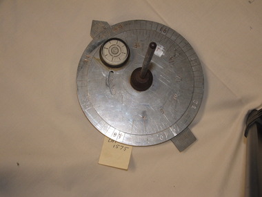
Functional object - Sun Compass
This type of kit was used by the Regiment for vehicular cross country navigation. The crew commander would stand in front of the vehicle with a prismatic compass and guide the driver to align the vehicle on the back bearing of the required direction of travel. The discs were set for time of day and the required bearing and the driver would watch the compass and steer so that the shadow of the gnome was on the arrow. The compass would be re-set about every half hour to adjust for rotation of the Earth. In featureless country navigation was by dead reckoning by direction travelled by compass and distance travelled from the vehicle odometer. Armoured vehicles are now equipped with GPS navigation aids rendering the sun compass obsolete Type of equipment used by the Regiment on exercisesMetal construction. One fixed and one rotatable aluminium disc with a vertical steel gnome at the centre. The lower disc is marked with bearings in mils, the upper with time of day. There is a rotatable aluminium arrow under the 2 discs. A 33 mm dia spirit level is fixed to the top disc.On spirit level "GENERAL #847"daytime use only, navigation aid -
 Eltham District Historical Society Inc
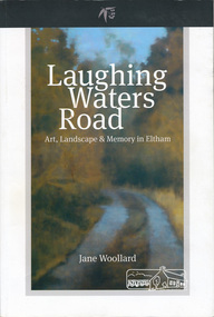
Book, Shire of Nillumbik, Laughing Waters Road: art, landscape & memory by Jane Woollard, 2016
"Laughing Waters has been a source of inspiration for many artists and designers, and was a natural extension of the dynamic art and lifestyle movement that began in the 1930s at Montsalvat. It was also an important site in the development of the Melbourne art scene in the 1960s and '70s, especially the earth building movement known as the Eltham Style. Since 2001 more than eighty artists have been in residence at Laughing Waters in Birrarung House and Riverbend. Their experiences and art making are woven together with Wurundjeri, European and family histories to create an evocative account of a special place in a bushy outer suburb of Melbourne." -- back cover. Eltham District Historical Society is acknowledged in the Acknowledgments section of this book.264 pages : illustrations, maps, portraits ISBN 9780994486707laughing waters, eltham, yarra river, artists, killeavey, mud bricks -
 Warrnambool and District Historical Society Inc.
Book, Alone in West Africa by Mary Gaunt, Printed 1912
“Alone in West Africa” is one of a number of works written by Mary Gaunt. Her other works include, A Woman in China, The End of the Earth, Kirkhams Find, The Moving Finger and Deadman’s. Mary was born at Indigo near Chiltern in 1862 and lived for many years in Ballarat where her father W.H. Gaunt was gold commissioner and later a judge. The original Gaunt family home was converted into St Patrick’s College. She married Dr Lindsay Miller and moved to Warrnambool and after his death in 1899 she embarked on her travels which took her to many parts of the world. She died in Cannes, France in January 1942. Mary Gaunt wrote over 25 novels, numerous travel books and many stories and articles. She had a strong link with Warrnambool and details of the district are included among her writings. She also wrote regularly in the early 1900’s for the Times in London on women issues. She was an independent thinker and worker. Apart from the text of “Alone in West Africa,” the work contains 97 black and white photographs which Mary had taken and developed herself. These photos are a significant view of aspects of life in Africa at that timeDark blue cover with gold text. Title, “Alone in West Africa” with sketch of two children in the centre, with Mary Gaunt underneath. The back cover has an embossed letter “L”. Inside the front cover is a rough sketch of the author’s route of the French Ivory Coast. It contains a number of black and white plates and index. 399 pages.T Werner Laurie on bottom of spine. Black and white photograph of author with autograph underneath. T Werner Laurie Clifford’s Inn London. Acknowledgements included in the dedication , Sir Charles Lucas, Sir George Denton, Elder Dempster and Co. Messrs. Swanzy and Co.,gaunt, mary gaunt, alone in west africa, french ivory coast 1912 -
 Churchill Island Heritage Farm
Tool - Three Quarter Yard Scoop, Gaston & Sons, 1920
The Three Quarter Yard scoop was used to scrape out and relocate dirt. Early scoops would be dragged behind horses with the worker guiding direction. In later years scoops were attached to a tractor. The dragging collected dirt in the bucket, the bucket was then raised and the contents taken to be dumped. The scoop could also flatten earth. This scoop may have originally sat in a chassis with wheels and tow bar. Early agricultural photos of scoops show their use on Victorian farms in dam and road construction. The manufacturers are Gaston Bros who produced farming equipment in Kensington, Victoria until 1988. This particular scoop was recovered from a San Remo property.Scoop, three quarter yardGaston 3/4 Yardfarm machinery; scoop; horse drawn -
 Melton City Libraries
Photograph, Peter Barrie, 1963, Unknown
Peter Ernest born Nov 7th 1945. Peter and his brother Robert continued operating the farm on Ferris Road. Peter remembers the horses being used. Robert and Peter worked with their father uncles and cousins until the decline of farming and the impending division of the properties and the encroaching urban development made farming no longer viable. The remaining connection of the Barrie family with property known as Darlingsford finally ceased in 1982. Peter continues to combine a small farm with his earth moving business, known as Melton Plant Hire (MPH) . Peter’s wife Jennie and daughters Deborah and Coralie administer the MPH (Melton Plant Hire) Office, and assist with operation the machinery. Photographs of Peter Barrie from different eraslocal identities, agriculture -
 The Beechworth Burke Museum
Postcard, George Symons, c.1990
The photograph printed on this postcard comes from the collection of the Mitchell Library in Sydney. It is sepia in tone and depicts seven men standing and sitting around a mine shaft in the Beechworth region. The photograph has been dated to approximately 1872. This period in history post-dates the Victorian gold rushes which occurred 1852-1853 in Ballarat, Bendigo and Beechworth. During this period, in the 1870s, the surface alluvial gold had been discovered and removed from location. Therefore, in order to reach the deeper and less accessible alluvial gold, diggers began to dig shafts into the earth. These shafts sunk below the ground level by 20 to 30 feet and required timber structures around the entrance and winches to bring the paydirt to the top. The top of this wooden structure is visible behind the man standing in the upper right of the image. This type of mining was highly dangerous as mines often caved in which injured the minors and often resulted in death. Thus, following this period, in the early 1900s, miners opted instead for hydrolic slucing which cut away the earth without the devastating consequences of a mine cave in. This particular group of miners appear to have been unable to afford a horse (then worth around 50 pounds) which were generally used at mines like this to help pull buckets attached to ropes up and down the mine. Instead, this group brought the buckets up and down by windlass. The windlass was a wooden structure mounted over the mining shaft and fitted with a hand-cranked winch which enabled the bucket attached to the rope to be brought up and down.Gold was first discovered in Beechworth in Spring and Reid's Creek in the summer of 1852-1853. At its popularity, this region had approximately 8000 people on the gold fields searching for gold on the banks of these creeks. These periods did not require the use of heavy machinery or the digging of deep mining shafts like the one depicted in this image. Therefore, this image has important connotations for the technologies associated with mining during the approximated 1870s when gold was harder to access. This is a later period in gold history which does not fit into the "gold rush" period. Instead, it occurred after the surface gold had disappeared and therefore, is essential for researchers who are investigating the mining techniques and structures used to reach the alluvial gold which was located deeper under ground in the 1870s. This period predates the use of big heavy machinery used to mine in the 1900s which include dredges. Images such as this one can also impart essential information as to the wardrobe and fashion of men during this period. It also imparts knowledge about the landscape of Beechworth which is useful for people researching the environment and impact of gold mining in the north-east region of Victoria. In addition, since this image is a postcard reproduction of an early Australian image which may date to approximately 1990 it can impart knowledge as to the interests of people during this time period when there may have been an increase into Australian history.A sepia tone facsimile of an early Australian photograph (circa 1872) printed as a postcard.Obverse: BEECHWORTH / Victoria, Australia / Reverse: GM 2 3275 / CORRESPONDENCE / AUSTRALIAN / YESTERYEAR / CARDS / ADDRESS / Published by George Symons (057) 65 3240 / THE MINEHEAD C. 1872 / The easily gleaned gold of the early fields did / not last very long. In order to reach less / accessible alluvial gold diggers began sinking shafts as much as twenty to thirty feet down / and the mines required timbering and winches / to bring the paydirt to the top. / This syndicate has been unable to afford the / luxury of a horse (about 50 pounds) and so everything / must go up and down by windlass and rawhide / bucket. / Photo: Mitchell Library, Sydney / A sepia tone facsimile of / an early Australian photographmining album, gold mine, beechworth, burke museum, mine shaft, postcard, australian yesteryear cards, george symons, the minehead, gold fields, alluvial gold, early australia, c.1872, 1872, gold diggers, north east victoria -
 Kiewa Valley Historical Society
Electric Megger (Insulation Tester) and its case
Megger as the device was called, is in fact its brand name. It is a device that supplies a DC (direct current as per car batteries) voltage to enable testing of electrical apparatus. This particular device produces 250volts DC when the handle is turned vigorously. If an electrical device, such as a kettle or toaster, blew a fuse or tripped a circuit breaker, when switched on, then it must be checked electrically before any more use. Following the repair of the faulty item a megger would be used to check if either of the AC 240volt plugs leads were touching the metal case (earth). The output leads of the megger would be connected with one to the earth (metal case) and the other to each of the power connections in turn. A good megger reading of 50,000 ohms (resistance) would enable the device to be returned to service. A reading of zero ohms resistance would mean that it would again blow a fuse, and was therefore unsafe to use. In the electrical industry e.g. the former State Electricity Commission, a megger would be used to test lots of similar item in sequence. Because of the vigorous job of winding the handle, two persons were often used to save time. One would crank madly whilst the other shifted the leads. This particular megger is of a small voltage, but other meggers are bigger and have a few ranges of DC voltages able to be selected. The optimal megger for large Generating machines was motor driven megger. This was applied to the device being tested for a duration of approximately 30 minutes with reading of the resistance taken at regular intervals.All equipment belonging to the State Electricity Commission of Victoria was labelled with a metal plaque attached to it. The SECV constructed the Kiewa Hydro Electric Scheme in the Upper Kiewa Valley and on the Bogong High Plains. The scheme began in 1938 and finished in 1961 when this megger was used and also possibly later as the SECV remained to maintain and operate the Scheme. This megger is of significance in relation to the advancement of technology.A rectangular box in dark brown bakerlite casing. It has an agent's plaque fixed to the left of the face and on the right is the marker's recessed stamp. In the middle in a transparent window so the level of ohms can be read. The front also has two recessed fixing knobs in black. On one side is a crank handle with a knob that lifts up and is turned vigorously to create the voltage. The back has four recessed screws and four small leather pads. There is a hole on each side to insert wires. There are two copper insulated wires. The SECV Plaque states: State/Electricity Commission/of/Victoria/ Electrical Engineer's Section/ No.1747 The Agent's Plaque states: H. Rowe & Co. Pty Ltd/Melbourne & Sydney/Sole Agents/in Australia for/Evershed & Vignoles Ltd Maker's states: 500 volts/Megger/Regd Trade Mark/Made in England/Patent No/400728electrical meters, electrical equipment, fuses, safety, state electricity commission of victoria, mt beauty, bogong village -
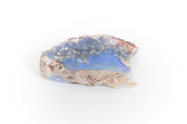 The Beechworth Burke Museum
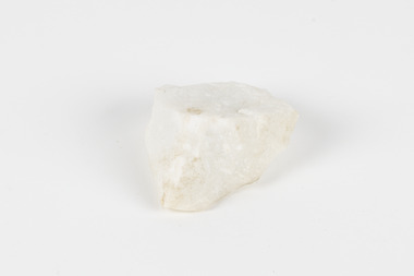
Geological specimen - Precious Opal
In Australia, precious opal is found in Cretaceous age sandstones and mudstones. These sedimentary rocks were deeply weathered and this weathering released silica into the groundwater.Australia is the only part of the world where opalised animal and plant fossils have been found. Opal artefacts several thousands of years old have been discovered in East Africa. As early as 250 BC the Romans prized opals, thought to have come from mines in Eastern Europe, the ancient world's main source of opals. There are many aboriginal dreamtime stories that feature opal. Australian opals discovered during the late 1800's found little favour with European markets but their commercial value increased in the 1900's and in 1932 Australia took over as the major producer of opals in the world and remains the largest producer to this day. Opal is found around the world (Brazil, Mexico, Honduras and the western US) however Australia produces 95% of the world's precious opal and it is our official national gemstone. Opal was first mined commercially at Listowel Downs in Queensland in 1875 and later at White Cliffs in NSW. Today, Coober Pedy (SA) is the main producer of white opal, though in recent years this field has expanded and all types of opals are found. Other centres in SA include Andamooka and Mintabe. Lightning Ridge (NSW) is renowned for black opal and formerly White Cliffs was a large producer of high quality opal. Boulder opals (opals in concretionary ironstone) are mined in Queensland from numerous localities in a zone extending from the Eulo and Cunnamulla district in the south and northwest for a distance of over 700 km to Kynuna in the north. The towns of Quilpie, Yowah and Winton are the main opal mining and wholesale centres. Opals are considered gemstones and have been used in jewellery for thousands of years.Throughout much of history, opals were actually believed to be good luck. The Romans thought that opals were one of the luckiest gemstones and a symbol of hope. In the Middle Ages, opals were believed to be bestowed with all the positive properties of coloured gemstones due to its rainbow-like play of colour. Finally, there is a superstition that you should not wear an opal unless it is your birthstone otherwise misfortune will befall you. This, of course, is far-fetched, but the notion could have been promoted in the late 19th and early 20th Centuries by diamond traders who were trying to increase sales of diamonds and deter people from buying opals. Possibly related to this is the thought that you should set opal jewellery with diamonds as their powers of good fortune will override any negativity held by the opal. The great majority of opal does not show play of colour and is called common opal or potch however this is not the case with a precious opal. Opal is a precious gemstone, like rubies, emeralds or diamonds. Opal is rare, and it is expensive to prospect and mine for.Silica is one of the most common minerals on the planet, but precious opal is very rare – far more rare than diamonds. Precious opal is rare because the natural processes that create it rarely occur.Most (at least 95%) of the opal found by miners is common opal without gem colour. In Australia we call it potch. It can be white, grey, black or amber coloured. Even when a miner finds gem-coloured opal, most of it can’t be cut into gemstones because it’s too thin, or sandy. This specimen is part of a larger collection of geological and mineral specimens collected from around Australia (and some parts of the world) and donated to the Burke Museum between 1868-1880. A large percentage of these specimens were collected in Victoria as part of the Geological Survey of Victoria that begun in 1852 (in response to the Gold Rush) to study and map the geology of Victoria. Collecting geological specimens was an important part of mapping and understanding the scientific makeup of the earth. Many of these specimens were sent to research and collecting organisations across Australia, including the Burke Museum, to educate and encourage further study.It is not known where this opal originated, except that it is probably from Victoria, as it has been recorded from many localities in the State. Common Opal is formed from silica-rich water circulating through rocks near the Earth’s surface. It consists of minute spheres of silica arranged in different ways. In common opal, the spheres are of different sizes and randomly arranged, unlike in precious opal where the spheres are of similar size and uniformly arranged in three dimensions. These differences account for common opal generally being translucent to opaque and without the play of colours, or opalescence, displayed by precious opal. Common opal is found in many localities and different geological environments throughout Australia and the world. Precious opal requires special conditions to form and is much less common. Australia produces most to the world’s precious opal. burke museum, beechworth, indigo shire, beechworth museum, geological, geological specimen, precious opal, opal, brazil, mexico, honduras, queensland, coober pedy, gemstones, jewellery, play-of-colour, light blue -
 Orbost & District Historical Society
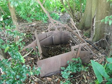
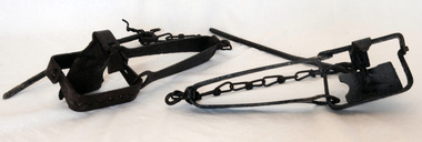
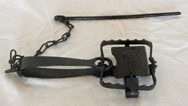
rabbit traps, First half 20th century
During the Great Depression from 1929 to 1932, rabbit trapping was a means of survival for many people. Rabbits provided meat and pelts which were sold for making felt hats such as the Akubra. Rabbit populations are controlled in the 21st century by poisoning, destroying or 'ripping' burrows (warrens), biological control with rabbit haemorrhagic disease and myxomatosis, and by shooting. Rabbit-proof fences also prevent the spread of rabbits into some areas. (ref. Powerhouse Museum) Steel-jawed rabbit traps were widely used in urban and rural Australia from 1880 to 1980. This trap is symbolic of the battle that Australians have waged against burgeoning rabbit populations for over a century. Rabbits cause enormous damage to Australian soils and biodiversity. The introduction of rabbits to this country was an environmental disaster.Two iron rabbit traps. Each consists of a pair of jaws held closed by spring tension and a triggering mechanism. When the trap is triggered the jaws close over the top of the bridge, plate and tongue mechanism that is designed to trigger the trap. A chain is attached by a hook on the bent end of the trap's spring with a long steel spike looped over the last link of the other end of the chain. The trap is designed so that the metal jaws snap shut against each other when the trap is activated by the application of weight to the pressure plate. In use, traps are set with open jaws, buried lightly just below the surface of the earth. When an animal steps on the pressure plate, the jagged teeth of the jaws snap around the animal's leg, usually breaking bone and sinew. Thus the animal is immobilised.rabbits rural trapping -
 Orbost & District Historical Society
rabbit trap, first half 20th century
During the Great Depression from 1929 to 1932, rabbit trapping was a means of survival for many people. Rabbits provided meat and pelts which were sold for making felt hats such as the Akubra. Rabbit populations are controlled in the 21st century by poisoning, destroying or 'ripping' burrows (warrens), biological control with rabbit haemorrhagic disease and myxomatosis, and by shooting. Rabbit-proof fences also prevent the spread of rabbits into some areas. (ref. Powerhouse Museum) This trap was used in the Orbost district. Steel-jawed rabbit traps were widely used in urban and rural Australia from 1880 to 1980. This trap is symbolic of the battle that Australians have waged against burgeoning rabbit populations for over a century. Rabbits cause enormous damage to Australian soils and biodiversity. The introduction of rabbits to this country was an environmental disaster.A rusted iron rabbit trap which consists of a pair of jaws held closed by spring tension and a triggering mechanism. When the trap is triggered the jaws close over the top of the bridge, plate and tongue mechanism that is designed to trigger the trap. A chain is attached by a hook on the bent end of the trap's spring with a long steel spike looped over the last link of the other end of the chain. The trap is designed so that the metal jaws snap shut against each other when the trap is activated by the application of weight to the pressure plate. In use, traps are set with open jaws, buried lightly just below the surface of the earth. When an animal steps on the pressure plate, the jagged teeth of the jaws snap around the animal's leg, usually breaking bone and sinew. Thus the animal is immobilised. rabbit-trap rural -
 Bendigo Historical Society Inc.
Book - GOLDEN SQUARE LAUREL STREET P.S. COLLECTION: NATURE NOTES
Shiny black covered exercise book with hand written notes and ink illustrations, titled Nature Notes. Initials in the front J.C. 9/10/40. Written index in the front. Items mentioned are: The Dahlia, The peach, The Pear, The Cosmos, The Bathurst Burr, Autumn Leaves, Jonquil, Roots, The Wattle, Orange, An Insect, Mantis, Magpie, Mosquito, Termites, Jackass, Spider, Earth-worm, Violet, Cape-weed, Iceland Poppy, Beaks of Birds, Feet of Birds, The Snail, The Rose, Emperor Gum Moth, The Bee and the Chrysanthemum. From Page 101 on Observations in Nature. Book also includes the loose printed notes pasted to orange card titled Air, Evaporation and Smells and Growing Chrysalis. Some Nature Notes in the form of a diary at the back of the book.education, primary, golden square laurel st p.s., golden square laurel street p.s. collection - nature notes, observations in nature -
 Wodonga & District Historical Society Inc
Album - Hume Reservoir Australia Album - Concrete pillar for tall tower, New South Wales, August 1927, 1927
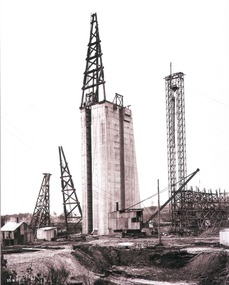
This set of photos is from a leather bound album bearing the inscription "HUME RESERVOIR AUSTRALIA" plus 'The Rt. Hon. L. C. M. S. Amery, P. C., M .P.' all inscribed in gold. It was presented to The Rt. Hon. L. C. M. S. Amery, P. C., M. P, Secretary of State for Dominion Affairs on the occasion of his visit to the Hume Reservoir on 2nd November 1927. This album is of local and national significance as it documents the planning and development of the Hume Reservoir up to 1927. It was the largest water reservoir in the British Empire. The album records the pioneering engineering work that went into its construction.DEPARTMENT OF PUBLIC WORKS, N.S.W. RIVER MURRAY WATERS SCHEME. HUME RESERVOIR. 28. Concrete Pillar for Tail Tower. This shows the back and upstream side of the tower. The groove at the back is left for the reception of the concrete core wall of the earth embankment. The groove is being used at present as a hoist well, up and down which men and materials are conveyed in connection with the re-erection of the Tail Tower of the cableway. The pillar is 108 feet from the ground and is within 4 feet of its ultimate height. The foundation of this part at its deepest is 90 feet below the natural surface so that when the 80 feet tower and jury mast are in place the total height from foundation to top of mast will be about 300 feet. New South Wales, August 1927.hume reservoir australia, river murray waters scheme, hume reservoir construction -
 Melbourne Tram Museum
Document - Report, Melbourne & Metropolitan Tramways Board (MMTB), "MMTB Passenger Shelters as at", c1978
Set of 3 Reports and one photograph, titled "MMTB Passenger Shelters as at" .1 - 16 foolscap pages, dated 1/4/1979, listing the route, route number intersection, tram stop, identification number, and type. Includes bus routes. .2 - ditto, 17 pages, dated 8/10/1979, prepared by R. G. Vanselow .3 - similar 8 pages, with hand written notes and giving drawing numbers. .4 - colour photograph of modular steel and glass type at stop 19, possibly St Kilda Road. Stop 19 in St Kilda Road was at Toorak Road, but the building is not there on Google Earth. Stop 19 on Flemington Road is at Abbotsford St (a Service Station) and Stop 19 Royal Parade is at College Crescent.trams, tramways, tram stops, tram shelters, bus routes -
 The Beechworth Burke Museum
Geological specimen - Marble, Unknown
A granular metamorphic rock, marble is derived from limestone or dolomite and composed of calcite or dolomite interlocking grains. Heat and pressure from overlying sediments form it from limestone buried deep in Earth's crust. Graphite, pyrite, quartz, mica, and iron oxides can affect rock texture and colour. This specimen was found in Carrara, Italy. Carrara marble is the most common marble found in Italy, and it gets its name from the region where it is located. The marble was also called Luna marble and was used as a decorative element in buildings and sculptures. It has been quarried since Roman times in the Lunigiana, the northernmost tip of Tuscany, just outside the city of Carrara in the province of Massa and Carrara.Marble is one of the most popular and expensive rocks used in sculpture, architecture, interior decorations, statues, table tops, and novelties. It is available in various colors and textures depending on the chemical composition. The strength of the rock and its ability to hold finer details have made it a favorite among designers. This specimen is part of a larger collection of geological and mineral specimens collected from around Australia (and some parts of the world) and donated to the Burke Museum between 1868-1880. A large percentage of these specimens were collected in Victoria as part of the Geological Survey of Victoria that begun in 1852 (in response to the Gold Rush) to study and map the geology of Victoria. Collecting geological specimens was an important part of mapping and understanding the scientific makeup of the earth. Many of these specimens were sent to research and collecting organisations across Australia, including the Burke Museum, to educate and encourage further study.A solid hand sized Marble (metamorphic rock) predominantly white with specks light grey and ochre geological specimen, geology, geology collection, burke museum, beechworth, marble, carrara marble, italian marble, marble specimen, tuscany -
 The Beechworth Burke Museum
Photograph
The photograph depicts a mine cut with a tractor. Water is being used to sluice the front of the tractor, possibly to separate any gold that may have been picked up from the earth. A few people watch the demonstration. Water was a significant part of gold mining in the Beechworth area and miners used a method known as 'hydraulic sluicing'. Due to the amount of water required, many water races were constructed throughout the Beechworth Mining District. These were cut through solid rock and are an example of engineering achievement. Water usage in the area put Beechworth at the heart of water policy, with many firsts for Victorian colonial goldfield water management being established in the Beechworth Mining District. This photograph is significant as it depicts the use of water in gold mining in Beechworth. Beechworth was notable for it's use of water in mining.Black and white square photograph (portrait orientation) printed on matte photographic paper.Reverse: SW-50-2 / 1997 31136 / unreadable pencil markingssluicing, gold mining, mining, hydraulic sluice, hydraulic sluicing, beechworth mining district -
 The Beechworth Burke Museum
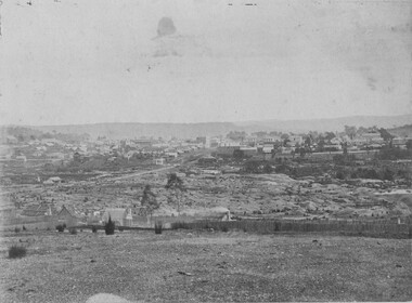
Photograph, 1865
This image was taken in 1865 overlooking the diggings at Spring Creek, Beechworth. Gold was discovered in this area in 1852 and within eleven months of this discovery, over 8000 hopeful prospectors had descended on the region, transforming the seemingly undisturbed land into what a visiting journalist in 1880s referred to as; "A Titan's Field". Huge mounds of earth were churned by hundreds of miners in search for gold, almost every available resource the land had to offer was used for something; even the bark off the gums were stripped to line huts and shafts. By 1857 more than 20,000 people lived in Beechworth, and with this influx the town prospered with the building of numerous churches, banks, schools, shops and hotels along with a prison and hospital.Black and white rectangular photograph. Image is printed on matte photographic paper and is mounted on cardboard. Obverse: NO INSCRIPTION Reverse: 7771 / BEECHWORTH / FROM SPRING CREEK / 1865 spring creek, diggings, beechworth, 1865 -
 The Beechworth Burke Museum
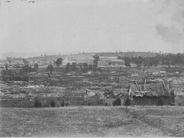
Photograph, 1865
This image was taken of the diggings at Spring Creek. In February 1852 gold was discovered at Spring Creek, Beechworth. Within eleven months of this discovery, over 8000 hopeful prospectors had descended on the region, transforming the seemingly undisturbed land into what a visiting journalist in 1880s referred to as; "A Titan's Field". Huge mounds of earth were churned by hundreds of miners in search for gold, almost every available resource the land had to offer was used for something; even the bark off the gums were stripped to line huts and shafts. By 1857 more than 20,000 people lived in Beechworth, and with this influx the town prospered with the building of numerous churches, banks, schools, shops and hotels along with a prison and hospital.Black and white rectangular photograph. Image is printed on matte photographic paper and is mounted on cardboard. Obverse: NO INSCRIPTION Reverse: BMM6926 / BEECHWORTH FROM SPRING CREEK 1865 spring creek, beechworth, burke museum, 1865, gold rush -
 The Beechworth Burke Museum
Geological specimen - Basalt (igneous-volcanic) containing Olivine, unknown
This particular geological specimen was found in Mount Franklin or Lalgambook in Djadjawurrung, located between Daylesford and Newstead, approximately ninety minutes drive from Melbourne. The mountain is an example of a breached scoria cone (a steep conical hill of loose pyroclastic fragments) which was created by a volcanic eruption about 470,000 years ago, a date which may indicate the age of this geological specimen. The volcanic eruptions of Mount Franklin were most likely witnessed by members of the Dja Dja Wurrung Aboriginal tribe, who referred to this country as the 'smoking grounds'. Mount Franklin and the surrounding area appears to have been a place of considerable religious significance to Aboriginal people, there is evidence which indicates that frequent large ceremonial gatherings took place in the area. Basalt is the most common rock on Earth’s surface, more than 90% of all volcanic rock on Earth is basalt. Basalt is an aphanitic extrusive igneous rock formed from the rapid cooling of low-viscosity lava exposed at or very near the surface of a rocky planet or moon. Specimens are black in colour and weather to dark green or brown. Basalt is rich in iron and magnesium and is mainly composed of olivine, pyroxene, and plagioclase. Olivine is the name of a group of rock-forming silicate minerals with compositions ranging between Mg2SiO4 and Fe2SiO4. Unlike other minerals, Olivine has a very high crystallisation temperature which makes it the first of the minerals to crystallise from magma. As magma cools, the crystals begin to form and settle on the bottom of the lava and form basalts that are abnormally enriched in olivine in the lower part of lava flows. According to H. M. King (on geology.com) "Olivine is thought to be an important mineral in Earth's mantle. Its presence as a mantle mineral has been inferred by a change in the behaviour of seismic waves as they cross the boundary between Earth's crust and mantle". Lava from Mount Franklin and other volcanoes in the area filled valleys and buried the gold bearing streams that became the renowned ‘deep leads’ of the gold mining era. In 1852, as part of the Victorian gold rush, gold was discovered in the immediate area, this gold was created by lava flows during the Newer Volcanic period, which were mined intensively during the nineteenth century. Around 1865 the presence of a deep lead in Mount Franklin was established. Deep lead mining was initially unsuccessful, and it was not until the late 1870s that the Franklinford Gold Mining Company mined at Mount Franklin on a significant scale. A few years later the Mount Franklin Estate Gold Mining Company also struck gold, followed by the Shakespeare and Great Western companies in the mid-1880s. By the late 1880s, however, deep lead mining had ceased in the area. Soon after gold was discovered in 1851, Victoria’s Governor La Trobe wrote to the Colonial Office in London, urging ‘the propriety of selecting and appointing as Mineral Surveyor for this Colony a gentleman possessed of the requisite qualifications and acquaintance with geological science and phenomena’. Alfred Selwyn was appointed geological surveyor in Australia in 1852 which began the Geological Survey of Victoria. In 1853-69 the Geological Survey issued under Selwyn's direction sixty-one geological maps and numerous reports; they were of such high standard that a writer in the Quarterly Journal of the Geological Society of London bracketed the survey with that of the United States of America as the best in the world. During his years spent in Australia, Selwyn collected numerous significant geological specimens, examples of which are held in collections such as the Burke Museum.This geological specimen is an example of basalt and olivine which shows the volcanic lava activity and geographical specific nature of Mt Franklin as a significant volcanic site. According to Agriculture Victoria 'The crater is one of the deepest in the Central Highlands area. It is a major megacryst site with some of the largest known Victorian examples of megacrysts of augite and an orthoclase. The small parasitic mound of Lady Franklin on the western flanks adds to the geological interest of the site'. This specimen also highlights the locality as a significant place for both indigenous activity and Victorian gold rush era mining practices. This specimen is part of a larger collection of geological and mineral specimens collected from around Australia (and some parts of the world) and donated to the Burke Museum between 1868-1880. A large percentage of these specimens were collected in Victoria as part of the Geological Survey of Victoria that begun in 1852 (in response to the Gold Rush) to study and map the geology of Victoria. Collecting geological specimens was an important part of mapping and understanding the scientific makeup of the earth. Many of these specimens were sent to research and collecting organisations across Australia, including the Burke Museum, to educate and encourage further study.An angular, solid hand-sized piece of grey volcanic Basalt with green/brown Olivine phenocrysts along one flat edge.Olivine in basalt / - label is probably / correct. / C. Willman / 15/4/21burke museum, beechworth, indigo shire, beechworth museum, geological, geological specimen, mineralogy, basalt, igneous rock, igneous-volcanic, volcanic geology, volcanic, olivine, olivine specimen, basaltoid -
 The Beechworth Burke Museum
Photograph
This image shows an unknown location in the area of Beechworth that was possibly used as a sluicing mining site for gold during the Victorian Gold Rush. This era saw an influx of Chinese immigrants and Australian prospectors hoping to strike it rich on the fields. Many companies such as the Rocky Mountain Extended Gold Sluicing Company Ltd and the Cocks Pioneer Gold &Tin Sluicing Company also set up mines in the area. This site may be the location of one of these company's mines. The wooden logs are reminiscent of known sluicing operations in the era from that time. Sluicing involved the use of high-pressured hoses to clear away soil from earth that had been dug up by miners and was a popular method of excavation in the area, although it had severe impacts on the environment.The search for gold is ingrained into the history of Victoria and therefore, images like this one which portray an open cut sluicing site can reveal important information for society and technology for the date when the photograph was taken. This image is of important historical significance for its ability to convey information about sluicing and the methods used to find gold. It also shows a location where sluicing was undertook which provides insight into the impact of sluicing on the environment at a time when it was done.A colour rectangular photograph printed on glossy photographic paperReverse: 6855 /beechworth, gold rush, sluicing, mining -
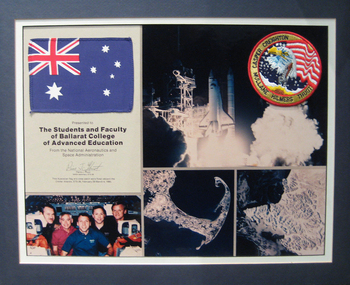 Federation University Historical Collection
Assemblage, National Aeronautics & Space Administration (NASA) presentation to the Students of the Ballarat College of Advanced Education
The assemblage was presented to the students of Ballarat College of Advanced Education (BCAE) by a NASA astronaut. The Australian Flag and NASA Astronauts crew patch were flown aboard the Orbiter Atlantis, STS-36, 28 February to 4 March 1990. Astronaut Pierre Thout's first flight was as a mission specialist on the crew of STS-36 which launched from the Kennedy Space Center, Florida, on February 28, 1990, aboard the Space Shuttle Atlantis. This mission carried Department of Defense payloads and a number of secondary payloads. Following 72 orbits of the Earth in 106 hours, the STS-36 mission concluded with a lakebed landing at Edwards Air Force Base, California, on March 4, 1990, after travelling 1.87 million miles. bcae, nasa, space, pierre thuot, creighton, caspar, mullane, hilmers -
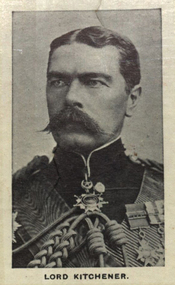 Federation University Historical Collection
Photograph (black & White), Horatio Herbert Kitchener, 1st Earl Kitchener - South Africa
For his achievements in the Battle of Omdurman and Sudan in 1898, Kitchener was made Lord Kitchener of Khartoum, becoming an Earl - qualifying peer of mid-rank. Kitchener was a senior British Army officer and colonial administrator who won notoriety for his campaigns, most especially his scorched earth policy against the Boers and his establishment of concentration camps during the Second Boer War. Awards he received include: Knight of the Order of the Garter; Knight of the Order of St Patrick; Knight Grand Cross of the Order of the Bath; Member of the Order of Merit; Knight Grand Commander of the Order of the Star of India; Knight Grand Cross of the Order of St Michael and St George; Knight Grand Commander of the Order of the Indian Empire. Individual imagae take from photographed poster of tobacco and cigarette cards.battle of omdurman, sudan, kitchener, earl, scorched earth policy, boers, concentration camps, colonial administrator, knight of the order of st patrick, knight of the order of the garter, knight grand cross of the order of st michael and st george, knight grand cross of the order of the bath, member of the order of merit, knight grand commander of the order of the star of india, knight grand commander of the order of the indian empire -
 The Beechworth Burke Museum
Photograph, 1865
Taken in Beechworth 1865, this photograph depicts the view of the Spring creek with the Beechworth township in the background. This photograph was taken 13 years after the discovery of Gold at Spring Creek. Within eleven months of the discovery in 1852, over 8000 hopeful prospectors had descended on the region, transforming the seemingly undisturbed land into what a visiting journalist in 1880s referred to as; "A Titan's Field". Huge mounds of earth were churned by hundreds of miners in search for gold, almost every available resource the land had to offer was used for something; even the bark off the gums were stripped to line huts and shafts. By 1857 more than 20,000 people lived in Beechworth, and with this influx the town prospered with the building of numerous churches, banks, schools, shops and hotels along with a prison and hospital.Black and white rectangular photograph. Image is printed on matte photographic paper and is mounted on cardboard.Obverse: NO INSCRIPTION Reverse: BMM6925 / BEECHWORTH FROM SPRING CREEK 1865 beechworth, spring creek, gold rush, titan's field, 1865, prospectors -
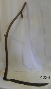 Flagstaff Hill Maritime Museum and Village
Tool - Scythe, 1930-1960
A Scythe was one of the most important of all agricultural hand tools, consisting of a curved blade fitted at an angle to a long, curved handle and used for cutting grain. In modern scythes the handle has a projecting peg that is grasped by one hand, facilitating control of the swinging motion by which grass and grain are cut. The exact origin of the scythe is unknown, but it was little used in the ancient world. It came into wide use only with agricultural developments of the Carolingian era (8th century AD) in Europe, when the harvesting and storing of hay became important to support livestock through winters. Scythes can still be found in use today by hobby farmers and permaculturists. ( producing food, by using ways that do not deplete the earth's natural resources) to cut grass in a more eco-friendly way as opposed to using a machine.A hand tool used for the cutting of crops and grain, modern versions are still being produced today in Europe. The subject item gives us a snapshot into agricultural practices in times past.Scythe with long wood Snath (curved handle) with 1 hand holding piece & curved blade. Noneflagstaff hill, warrnambool, shipwrecked-coast, flagstaff-hill, flagstaff-hill-maritime-museum, maritime-museum, shipwreck-coast, flagstaff-hill-maritime-village -
 Federation University Historical Collection
Booklet, Berry Anderson & Co, Ballarat School of Mines Student's Magazine, Fourth Term, 1907, 1907
Table of contents: Editorial, A motor problem, Electricity in mining, The wet assay of tin, Sintering slimes at the Broken Hill Pty Works, Smokeless cities, An unusual process for the treatment of concentrates, Diamond drilling, E. M. Weston, Recent advancements in the treatment of slimes from the reduction of gold bearing ores, Norman Stuckey, W. T. Cronow, The gold miner and the prospector, Cornish mining, A trip to the North-East, New Zealand coal, Rich mine water, Making standard solution of alkalies, Notes on the refining of base bullion, Pipe lines for corrosive liquors, Electro-galvanising, Ankylostomiasis or earth eating disease, News and notes, Method of preparing blue paper, Past students, Correspondence, Answers to correspondents, Magazine balance sheet, Editorial notices.Peach coloured booklet of 28 pages.Signed on front cover by Les? M. Deaneballarat school of mines, students' magazine, oliver wendell holmes, a. e. c. kerr, t. w. gronow, norman stuckey, e, m. weston, j. h. collins, s. b. vial,, t. w. hood, o. e. jager, hubert krause, s. j. lindsay, fred nettle, a. w. parramore, e. prendergast, basil a. reid, g. m. roberts, h. c. valentine, r. vaughan,, w. j. lakeland, d. scott, dave thomas, a. d. turner, tom williams, w. b. tucker, percy millar, o. c. witherden, john adam, h. f. denny, g. a. denny,, w. a. gosman, hilary dowling, d. m. deane, cecil eeles, j. o'farrell, t. f. fleetwood, miles a. gabriel, a. a. gibson, t. j. andrews, t. brennan, j. a. reid. -
Bendigo Historical Society Inc.
Pamphlet - Frank A. Hill and Co. 100 years, 1953
L. McPherson Sternberg and Co. was a large public company set up in Bendigo in the year 1853 especially to cater for the New South Wales consignments of cattle and horses which came regularly to Bendigo in those days to feed the thousands of hungry miners who had congregated from the four comcri:; of the earth in search of gold. The cattle were sold in the Municipal Cattle Yards ,and the horses in the Bazaar at Charing Cross. The founders of the business must have had tremendous faith in the future of Bendigo to have built such a large and solid structure as the Bazaar, including ample space for the administrative offices which, though reconstructed, are still basically as they were in the far-off fifties. When L. McPherson Sternberg & Co. retired from business in or about the year 1892, the business was acquired by Mr. Frank A. Hill. Frank A. Hill and Co. - a 14 page pamphlet outlining the history of the company and its 100 year development. Black and white, contains texts and photos.history, bendigo, frank a hill and co