Showing 5918 items
matching east road
-
 Glen Eira Historical Society
Article - CAMDEN TOWN
... East Brighton Road...’ Glenhuntly East Brighton Road Watts T. Surveyor Elsternwick Timbered ...This file contains three items. 1. Two copies of articles, dated 08/1857. The Argus neg 14 and roneoed copy neg 13 The Argus 16/07/1857 on benefits of living in Camden Town. 2. A photocopied photo of Camden Town Sports Club event undated and specific location unknown; and one photo on the corner of Glen Eira and Bambra Road. 3. Photocopied pages from Sands and McDougall 1874 of Caulfield c1900’s listing residents of Caulfield including Camden Town (three mentioned).‘camden town’, glenhuntly, east brighton road, watts t., surveyor, elsternwick, timbered, william gledhill (estate agent), camden town sports club, glen eira road, bambra road, attrill james t., o’brian john -
 Glen Eira Historical Society
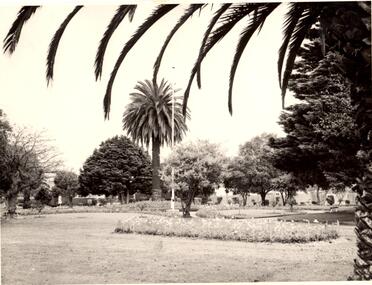
Photograph - Greenmeadows Gardens, St. Kilda East
... Gardens Greenmeadows Park St. Kilda East Neerim Road Hermes ...This file contains one item. 1. Four black and white photographs of Greenmeadows Gardens in St. Kilda East. Three of the Photographs have handwritten annotations and two are stamped identifying the printers as Hermes Studios on 356 Neerim Road, Carnegie. All Photographs are undated.greenmeadows gardens, greenmeadows park, st. kilda east, neerim road, hermes studios, carnegie, parks and reserves -
Glen Eira Historical Society
Document - Banks in Caulfield
... Caulfield East Derby Road 9... Carnegie Koornang Road 86 Caulfield East Caulfield East Derby Road ...This file contains two items. 1. A hand written list of branches of the English, Scottish and Australian Bank Limited and its merger the Australia and New Zealand Banking Group Limited, undated and author unknown. The list records the opening dates of branches in Carnegie, Caulfield East, Caulfield South, Elsternwick, Glen Huntly, Murrumbeena, Ormond, Garden Vale, Caulfield and Caulfield West encompassing years from 1886 to 1927, listing also the merger of the two banks as being in 1970 as well as 1852 as being the founding year of the English, Scottish, and Australian Bank Limited. 2. Three identical Elsternwick State Savings Bank withdrawal slips, from the 1910s. All three are blank, and include brief directions for filling in the slip typed at the bottom. Also included on the slip is a decorative illustration.banks, banks mergers, bank deposits, bank withdrawals, documents, banking, pass books, business and finance, annual reports, bank equipment, commercial equipment, bank branches, carnegie, carnegie koornang road 86, caulfield east, caulfield east derby road 9, caulfield south, caulfield south glen huntly road 790, elsternwick, elsternwick glen huntly road 324, elsternwick glen huntly road 426, glen huntly, glen huntly glen huntly road 1173, murrumbeena, murrumbeena murrumbeena road 59, ormond, ormond north road, ormond north road 553, garden vale, caulfield, caulfield west, caulfield hawthorn road 242, commercial establishments, the state savings bank of victoria, the state savings bank of victoria elsternwick branch, the english scottish and australian bank limited, the australian and new zealand bank limited, the australian and new zealand banking group limited -
Glen Eira Historical Society
Book - Chisholm Institute of Technology
... 900 Dandenong Road, Caulfield East, Victoria, Australia... Derby Road Caulfield East Dandenong Road Caulfield Chisholm ...Chisholm Institute of Technology’s Faculty of Technology Magazine, Feedback, No.3 1989. 1988 Prospectus of Chisholm Institute of Technology Official Invitation to opening of Continuity and Change, dated November 1985. Chisholm Institute of Technology Planning Brief (draft copy) dated 1985. Includes architectural drafts of campus. Fourteen pages including Building Plans. Official invitation to staff and students’ exhibition at Chisholm Institute of Technology 1983. Chisholm Institute of Technology Conferring of Awards booklet dated May 20, 1983. Includes list of graduates, staff and council. With handwritten notes on rear end pages. Undated brochure of advertising courses offered at Chisholm Institute of Technology. Loose card inside with description At Chisholm You’ll Get More Than Just A Piece Of Paper. Includes campus plans. Chisholm Institute of Technology Open Day brochure dated 1982. Includes map at back.vaughan geoffrey n. dr., jakovidis greg, mcleod ian, mckenry keith, chisholm caroline, jones b.o. hon., coogan c. k. dr., green k.d., aboriginal medicine, solar, engineering, applied physics, prospectus, chisholm history, school of art and design, david syme business school, school of education, school of nursing, school of social and behavioural studies, faculty of technology, centre for applied mathematical modelling, centre for business technology, centre for industrial tribology, centre for development of entrepreneurs, chisholm timber engineering technology centre, international business centre, polymer research centre, building plans, building construction, invitations, caulfield plaza, princes avenue, railway avenue, queens avenue, caulfield station, derby road, caulfield east, dandenong road, caulfield, chisholm institute of technology, caulfield campus, frankston campus, education, tertiary education -
 City of Moorabbin Historical Society (Operating the Box Cottage Museum)
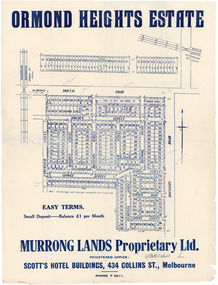
Flyer - Ormond Heights, East Bentleigh
... Boundary Road (now East Boundary Road)...) Boundary Road (now East Boundary Road) Murrong Avenue Bay View ...The train line from the city to Frankston was electrified which intensified the sale in the municipality of Moorabbin, particularly land which was in the vicinity of the railway stations.Example of the progress of the Municipality of MoorabbinAdvertising flyer for auction of real estate sales - plan of building blocks for salenorth road, moulden street, george street, garden road, bruce street (now bethwyn street), boundary road (now east boundary road), murrong avenue, bay view street, rochford street, mitchell street, lancaster street, east bentleigh, real estate -
Whitehorse Historical Society Inc.
Document, Motor Cycle Climb and mud bash|A Walk down memory lane|An early glimpse of Royton Street, 1994
... Road in 1929 - 30. History of Royton Street, East Burwood ...Hartwell Motor Cycle Club.Hartwell Motor Cycle Club. The East Burwood section of its run comprised Holland road, Burwood Road and Ely Road. It was very steep and muddy. Description of a walk along Burwood Road to Middleborough Road in 1929 - 30. History of Royton Street, East Burwood and its neighbourhood from the 1930's to the present.Hartwell Motor Cycle Club. motor cycles, hartwell motor cycle club, holland road, burwood east, eley road, burwood east, burwood east state school no 454, royton street, burwood east, walford family, orchards, cooinda court, burwood east, market gardens, east burwood methodist church, french, joseph a, black, roy, rescheck family, french, harry w, crow, ernie, mclean, leckie, newbigin family, royton street, burwood east, no 30, hele family, french family, carrol family, tally ho post office, walford family -
Whitehorse Historical Society Inc.
Legal record - Land Title, Certificate of Title, 23/12/1927 12:00:00 AM
... Middleborough Road Burwood East... Burwood East Highbury Road Burwood East 3 Acres 2 roods 8 and 7 ...3 Acres 2 roods 8 and 7/10th perches, pt. Crown section 108 Parish of Nunawading, owned by Thomas Gifford Anderson. Vol. 5411 fol. 10820053 Acres 2 roods 8 and 7/10th perches, pt. Crown section 108 Parish of Nunawading, owned by Thomas Gifford Anderson. Vol. 5411 fol. 10820053 Acres 2 roods 8 and 7/10th perches, pt. Crown section 108 Parish of Nunawading, owned by Thomas Gifford Anderson. Vol. 5411 fol. 1082005anderson, thomas gifford, middleborough road burwood east, highbury road burwood east -
 Whitehorse Historical Society Inc.
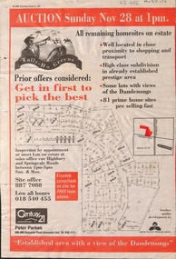
Newspaper - Article, Tally Ho Greens, 17/11/1993
... , 28-11-1993. auctions springvale road burwood east highbury ...Advertisement in the Post for auction of 81 home sites on the Tally Ho Estate.Advertisement in the Post for auction of 81 home sites on the Tally Ho Estate bordered by Springvale Road and Highbury Road, 28-11-1993.Advertisement in the Post for auction of 81 home sites on the Tally Ho Estate. auctions, springvale road, burwood east, highbury road, robinson drive, hoadley crescent, betts way, trainor place, sutton court, cole close, mcclelland way, kennard place, vision drive -
Whitehorse Historical Society Inc.
Newspaper - Advertisement, Bellevue Hill, 1971
... underwriting pty. ltd. mahoneys road burwood east springvale road ...Newspaper cutting advertising sale of Bellevue Hill Estate, East Burwood in 1971. Comprising 113 home sites. Estate bordered by Mahoneys Road and Springvale Roadland subdivision, land sales, development underwriting pty. ltd., mahoneys road, burwood east, springvale road, the sun property guide -
 Whitehorse Historical Society Inc.
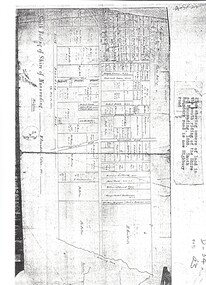
Map, Shire of Nunawading 1888
... road burwood east highbury road springvale road mahoneys road ...Plan showing owners of land in the South Riding of the Shire of Nunawading, 1888. South Boundary Road is now Highbury Road.shire of nunawading. south riding, south boundary road, burwood east, highbury road, springvale road, mahoneys road, forest hill, holland road, blackburn south, burwood highway -
Whitehorse Historical Society Inc.
Map, Survey for road from Doncaster to Ringwood, 01/03/1867
... Mitcham Doncaster Road Doncaster East Mitcham Road Mitcham Survey ...Survey in County of Bourke, Road Plan no. 390, showing early routes of Doncaster, Whitehorse and Mitcham Roads.Survey in County of Bourke, Road Plan no. 390, showing early routes of Doncaster, Whitehorse and Mitcham Roads. Measurement in chains. Surveyor: Thomas E. Rawlinson.Survey in County of Bourke, Road Plan no. 390, showing early routes of Doncaster, Whitehorse and Mitcham Roads. parish of nunawading, parish of bulleen, whitehorse road mitcham, doncaster road, doncaster east, mitcham road mitcham -
Whitehorse Historical Society Inc.
Map, Springvale Road, 1968
... Mitcham melbourne Aerial photographs Highbury Road Burwood East ...Aerial photograph of cnr Springvale Road and Burwood Highway, south past Highbury Road.Aerial photograph of cnr Springvale Road and Burwood Highway, south past Highbury Road.Aerial photograph of cnr Springvale Road and Burwood Highway, south past Highbury Road.aerial photographs, highbury road, burwood east, burwood highway, burwood east, springvale road, burwood east -
 Whitehorse Historical Society Inc.
Photograph, Subdivision of Area of Burwood, 1971
... Mitcham melbourne highbury road burwood east springvale road ...Black and white photo of Subdivision of Area of Burwood, Springvale and Highbury Roads.highbury road, burwood east, springvale road, burwood highway burwood east -
 Whitehorse Historical Society Inc.
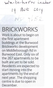
Article, Brickworks, 2019
... Burwood East Middleborough Road Burwood East Work is about ...Work is about to begin on the 267 residential apartments at the Burwood Brickworks site.Work is about to begin on the 267 residential apartments at the Burwood Brickworks site of which 261 have been pre-sold.Work is about to begin on the 267 residential apartments at the Burwood Brickworks site.brickworks, burwood east, middleborough road, burwood east -
 Whitehorse Historical Society Inc.
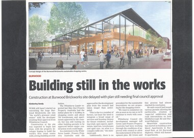
Article, Burwood Brickworks Shopping Centre, 2018
... east middleborough road eley road city of whitehorse Work still ...Work still hasn't started on building 'the world's greenest retail centre' due to the developer awaiting final approval from Whitehorse Council.brickworks, australand, burwood highway, burwood east, middleborough road, eley road, city of whitehorse -
 Whitehorse Historical Society Inc.
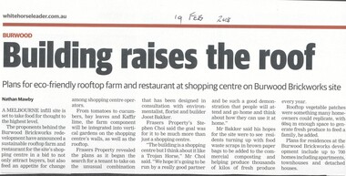
Article, Building Raises The Roof, 2018
... Whitehorse Historical Society Inc. 2-10 Deep Creek Road ...The proponents of the Burwood Brickworks redevelopment have announced a sustainable rooftop farm and restaurant for the site's shopping centre.brickworks, burwood highway, burwood east, middleborough road, eley road, restaurants -
 Whitehorse Historical Society Inc.
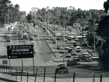
Photograph, Springvale Rd. and Burwood Highway intersection, 1999
... springvale road burwood east... Mitcham melbourne burwood highway burwood east springvale road ...Black and white photograph of the intersection of Burwood Highway and Springvale Rd. East Burwood. Sign on left of photograph. Small black car in foreground.burwood highway burwood east, springvale road burwood east -
 Ballarat Heritage Services
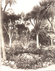
Image, Ballarat East Gardens, c1895, c1895
... main road ballarat east... Office goldfields ballarat east main road ballarat east ballarat ...Black and white image of the a fountain in the Ballarat East Gardens. ballarat east, main road ballarat east, ballarat east gardens -
Glen Eira Historical Society
Article - St Peter's Catholic Church, Bentleigh East
... East Boundary Road...844 Centre Road, Bentleigh East, Victoria, Australia... Francis Orrong Road Little Brighton Oakleigh Port Phillip Bay East ...Included In The File is A Newspaper Clipping From The Age Newspaper, Dated Sat 09/11/1974 On The Opening Written By Stuart Sayers. The Article Mentions A Brief History Of The Church & School Beginnings & The Opening Ceremony. There Are Two Copies Of The Living Harvest (One Without The Cover), The Book Gives A Detailed History Of St Peter's Catholic Church, Bentleigh East Written By W.T. Dobson And Published in 1974. From The First White Settlers, The Irish Exodus, And The Irish Catholic families, The School House And The History Of The Parish & Clergy Up To 1974.st peter's catholic church, niall patrick rev, emerald hill, bentleigh east, dobson w. t., yarra, moorabbin, heriot m. b., elsternwick, north road, quinn fred, bentleigh, centre road, kennedy james joseph, melbourne south, bignell road, kennedy market garden, oakleigh, st peter's parish, st james parish, the living harvest, catholic church, hibernian society, bavarian brass band, st peter's primary school, st james regional college, brighton catholic school, brighton – st kilda mission, niall patrick william fr, dendy henry, guiney john mr, king richard, king john, keys george, o’ shanassy john, keys robert, were jonathan b., o’ connell john fr, glass hugh mr, o’ farrell peter, brady peter, kennedy james, boland michael, mccormick francis, orrong road, little brighton, oakleigh, port phillip bay, east boundary road, north road, ormond, old dandenong road, mordialloc creek, moorabbin, springvale, no good damper road, kingstown, keysborough, bignell road, south road, heatherton, big brighton, gardenvale, elsternwick, brady road, jasper road, chesterville road, cochrane road, mcguinness road, h.a.c.b.s., school house, st patrick's church, brighton parish, denominational school, little brighton school, moorabbin catholic school, temporary chapel, st james regional college, sister of mercy, lanigans ball, east brighton public hall company ltd, east bentleigh hall, messrs. robert dunn & son, bavarian brass band, st joan of arc parish, east bentleigh parish, the sisters of our lady of sacred heart, the anchor club, mccormick cornelius, cochrane james, cochrane david, mcguinness margaret, cormick john, cahill james, quinn frederick, prendegast john patrick, naughton dennis, leary william, charlston john, carey matthew fr, gibbons patrick, kennedy joseph james, o’ sullivan tim fr, mckenna fred fr, casey william fr, browne joseph fr, crawford mal fr, hanrahan mr, gillon rose miss, sampson kate mrs, horan miss, coakley daniel fr, dillon kevin fr, whitehouse ray fr, mannix daniel dr, dobson william mr, gahan patrick, hallinan thomas, delaney john, fitzgerald patrick, st peter's catholic church -
 Melton City Libraries
Photograph, Western Highway, 1983
... East of Reserve Road towards Ferris Road... for over 100 years. Landscapes of significance Misc. East ...Construction of service road in front of the former Ann Dowling (Miers) 1866 Crown Grant, Title dated October 1870. She married Henri Miers in 1867.Their house was located on the site near the Myers Gully part of Ryans Creek. Built in 1867 and later named “Burnbank” by Martha Myers after the Street in Ballarat were she lived before arriving in Melton in 1907. She married Frederick Myers in 1908. He died in 1963, and Martha moved to a new home at 5 McKenzie Street Melton in 1968. Attempts made by the family to retain the historic cottage were unsuccessful. A demolition order imposed by the Housing Commission and it was pulled down by the family. It was the home of the family and stood for over 100 years.East of Reserve Road towards Ferris Roadlandscapes of significance, misc. -
 Melbourne Tram Museum
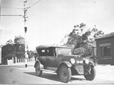
Photograph - 1926 Hudson Super 6 - Riversdale and Warragul Roads, Ray Pearson, 1930s
... was known as East Boundary Road. Behind the car on the tramway pole..., down end loop line, corner of Riversdale and East Boundary... are in plague. At the time, Warragul Road was known as East Boundary ...Photograph of a 1926 Hudson Super 6 parked at the tea room/kiosk on the intersection of Riversdale Road and Warragul Road. Distinguishing features of the car include the triangular badge on the radiator and the unusual disc wheels. The 1926 Hudson also had horizontal radiator shutters. On this vehicle, a finer mesh has been attached in front of the shutters. This is normal practice when insects such as locusts are in plague. At the time, Warragul Road was known as East Boundary Road. Behind the car on the tramway pole is a colour light tramway signal for the single-line section between Warragul Road and the terminus. On 1 July 1928, the Wattle Park line was extended from Boundary Road via Riversdale Road to Elgar Road. It was built as a single track with a passing loop about halfway along, plus a passing loop at the former Boundary Road terminus. The tramway pole has a stop sign and a telephone box as well. In a box of negatives received is an envelope noting the car was owned by Ray Pearson and photo taken during the 1930s. Inside the motor car are two people, the driver, and a lady. In the background is part of the tea rooms located at this corner with a Shell gravity-fed petrol bowser. At the time, petrol was not sold at Service Stations on a Sunday - Sunday trading laws, but they allowed Tea Rooms or kiosks to be open.Yields information the intersection of Warragul and Riversdale Road and MMTB single line signals.Black and white photograph on Velox paper.On rear in pencil "Colour light signal Wattle Park Route, down end loop line, corner of Riversdale and East Boundary Roads".trams, tramways, riversdale road, wattle park, warragul road, motor cars, hudson super 6, shell fuel, signalling, single line, ray pearson -
Whitehorse Historical Society Inc.
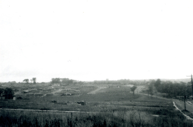
Map, Aerial photograph, c1950
... Aerial photo of Vermont South and Burwood East...Whitehorse Historical Society Inc. 2-10 Deep Creek Road ...Arial photo of Vermont South and Burwood East, Middleborough Road, Burwood Highway, Springvale Road, Highbury Road and environs.Aerial photo of Vermont South and Burwood East, Middleborough Road, Burwood Highway, Springvale Road, Highbury Road and environs.Arial photo of Vermont South and Burwood East, Middleborough Road, Burwood Highway, Springvale Road, Highbury Road and environs.vermont south, burwood east, aerial photographs -
 Whitehorse Historical Society Inc.
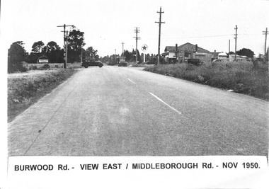
Photograph, Burwood Road 1950, 1/11/1950 12:00:00 AM
... Black and white photograph of Burwood Road. View east... and white photograph of Burwood Road. View east - corner ...Black and white photograph of Burwood Road. View east - corner of Middleborough Road Burwood in November 1950. 4 Copies.burwood road, burwood, middleborough road -
 Whitehorse Historical Society Inc.
Photograph, Blackburn Shopping Centre, 2012
... and Railway Rd Blackburn looking east. Blackburn Road coming... looking east. Blackburn Road coming in on the right ...Coloured photograph of intersection of Blackburn Rd and Railway Rd Blackburn looking east. Blackburn Road coming in on the right of the roundabout.blackburn shopping centre, shops -
 Brimbank City Council Art Collection
Photograph, Robert Pointon, Twin Pines, 1988
... East of Fairbiarn Road, South Sunshine, looking east... Landscape landscape photograph East of Fairbiarn Road, South ...Local LandscapeEast of Fairbiarn Road, South Sunshine, looking east - AR0002landscape, photograph -
 Greensborough Historical Society
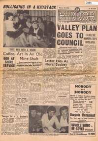
Newspaper, Elliott Provincial newspapers Pty Ltd, Diamond Valley Mirror May 4, 1965, 04/05/1965
... 1407 Burke Road , East Kew, Victoria, Australia ...Contains article "Valley plan goes to Council", discussing the development of the Plenty Valley, north of Greensborough.Early plan submitted to Diamond Valley Council in 19658 p.greensborough -
 Kiewa Valley Historical Society
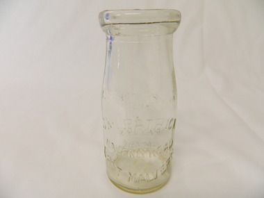
Bottle - Cream, 1935
... ) / Waverly Road (across middle) / East Malvern (half moon on bottom...Waverly Road, East Malvern, Melbourne, Victoria, Australia..., East malvern. Historical: Change of bottles - shape, size ...Cream came in bottles bought at the local store or at a large city store on a shopping expedition. The shape of the bottles changed as did the stopper used to seal it. The amount of liquid was measured in ounces and pints pre 1966. History of J. Kikpatrick, Waverley, East malvern.Historical: Change of bottles - shape, size, stopper, embossing and use. Aesthetic; Display showing embossing and shapeClear small glass cream bottle with heavy embossing on both sides. Inside the opening is a rim to hold a cardboard disc used to seal the bottle. The sides are straight half way up then taper to the opening. One side: The Property of / J. Kilpatrick (half moon on top) / Waverly Road (across middle) / East Malvern (half moon on bottom) Other side: Please / wash / & / Return (also curved with & in the middle) Along side at base: "Contents not less than 8 ozs." Base: Across middle M93 above M, and AGM below. cream, dairy, milkbar, bottle, household -
 Glen Eira Historical Society
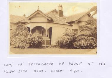
Letter - Maher, Francis Patrick
... re information about a property at 173 Glen Eira Road, St...173 Glen Eira Road, East St Kilda, Victoria, Australia... Road, St Kilda East. Included is a copy of Frank Maher’s ...Correspondence between Mr Frank Maher and Felicitie Ampbell re information about a property at 173 Glen Eira Road, St Kilda East. Included is a copy of Frank Maher’s recollections of people and places around east St Kilda area. Also includes a copy of a photograph of his childhood home c. 1930 and a map of the area around the property where he lived.st kilda east, elsternwick, caulfield, myrtle street, bailey ave, atley grove, glen eira road, hotham street, glenhuntly road, elizabeth street, regent street, balaclava road, mcwhae ave, gordon street, ripponlea mansion, caulfield grammar school, caulfield race course, elsternwick police station, caulfield city hall, city of glen eira city hall, glen eira historical society, holy angels catholic church, st. josephs catholic church, a.r.p. wardens, drill hall, brighton rifles, grocers, sweet shops, terrace houses, tennis courts, saddlers, billiard rooms, horse drawn vehicles, market gardens, motor cycles, fuel merchants, maher frank, tracey martin brian, tracey john edmond, tracey margaret, maher mary eleanor, maher martin john, tracey kathleen, bent thomas, nathan benjamin -
 Newcomb Secondary College Archives
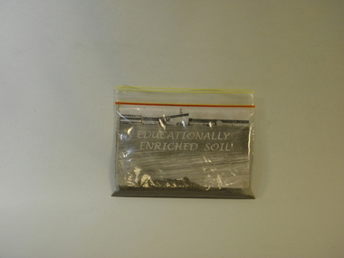
Curio - 2001 Bag of Educationally Enriched Soil, August 2006
... Boundary Road, East Geelong, Great Ocean Road, Victoria ...Soil collected for the 2006 Staff reunion of Geelong East Technical School/James Harrison College. The College merged with Newcomb Secondary College in 2001. The old site became part of The Gordon TAFE. The Reunion Committee wanted a memento of the school to give to the staff who attended.Clear Ziploc bag containing soil, organic material (Leaf) and paper.Side A Titled "Educationally Enriched Soil". Side B "Certificate of Authenticity./School/No.1765/geelong east technical school, james harrison college, 2006 -
 Ballarat Heritage Services
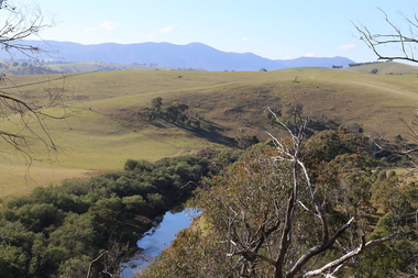
digital photographs, Lisa Gervasoni, Omeo High Plains, 2017
... Great Alpine Road, East Gippland Shire, Victoria, Australia ...Colour photograph of the Omeo High Plains.2017, great alpine road, omeo high plains