Showing 6426 items matching "housing"
-
 Queenscliffe Maritime Museum
Binnacle from Victoria Tower, see description
In memory of the owner's husband Chief Petty Officer(GNR) Frank Hillier RANHousing for a ship's compass with a window at the back to light the face of the compass during daylight and a small compartment on the right hand side with a hinged door for inserting a candle for night viewing (mounted on a wooden base)Model p 6: Magnetic Liquid Compass No 2767: Date 12-1956 WT 5 kgs: Manu. by C8879 T2757: Nunotani Keiki Seisakusho Ltd: Amagasaki: Japan -
 Wangaratta Art Gallery
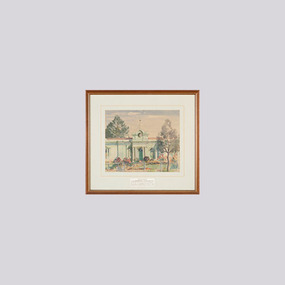
Painting, Mollie Hill, Borough Offices, 1962
Mollie Hill was a famous Welsh-born Australian watercolourist who studied at the Melbourne National Gallery Art School and is known for her 'eye for colour'. Her work features many landscapes of northern Victoria as she lived for some time in Shepparton and Wandiligong. She was also a well-known journalist. Depicted in this painting is the old council borough offices which were demolished in 1962. Rural City of Wangaratta Collection. Gift of Wangaratta Co-operative Housing Society No. 3 Ltd.A watercolour landscape of the old Wangaratta borough offices painted using shades of green, red, blue, and brown.Obverse: Mollie Hill/ (bottom right corner) PRESENTED/ TO THE BOROUGH OF WANGARATTA/ BY WANG. CO-OP. HOUSING SOCIETY/ NO. 3. LTD. IN APPRECIATION OF THE/ GENEROUS ASSISTANCE RECEIVED./ (in mounting board)wangaratta art gallery, mollie hill, watercolour, painting, landscape, borough offices -
 National Vietnam Veterans Museum (NVVM)
Booklet, Re-establishment Benefits for National Servicemen, 1/11/1969 12:00:00 AM
Booklet with 22 pages and olive green soft-cover outlining benefits paid to National Servicemen for such matters as reinstatement in civilian employment, post-discharge vocational training, retirement, housing, and protection of financial commitments.national service - australia, re-establishment, repatriation, payments, swainston collection -
Clunes Museum
Functional object - LANTERN
LANTERN USED ON WORK SITE - WARNING POSSIBBLE HAZARD.RED PAINTED LANTERN. FORMERLY OWNED BY PMG.([DEPARTMENT OF POST MASTER GENERAL) METAL CASE HOUSING, REMOVABLE FUEL BOWL RED LAMPSHADE, HANDLE TO HANG LANTERN ON LOW POST, HINGED LID.P.M.G.local history, lighting, kerosene, oil, lighting -
Whitehorse Historical Society Inc.
Newspaper - Article, Federal Plan to sell former Migrant Centre, 25/09/1985
Article from Nunawading Gazette, 25th September, 1985, re the Sale of Eastbridge Migrant Property in Rooks Road, Nunawading. The 22 1/2 acre site seems certain to be sold for Housing Development.eastbridge migrant hostel, rooks road, nunawading -
Whitehorse Historical Society Inc.
Letter - Correspondence, Schwerkolt Cottage, 7/11/1960
Letter from Housing Commission, Victoria to Mrs Jackschowsky re deferment of demolition of Schwerkolt Cottage, 7 November 1960. Declaration of unfitness for human habitation, 7 November 1960 and demolition order attached.schwerkolt cottage, jackschowsky, mary elizabeth, victoria. housing commission -
 Whitehorse Historical Society Inc.
Photograph, Narmara Primary School, 13/01/1994 12:00:00 AM
Coloured photo of Narmara Primary School looking North along East boundary. School on North side of Highbury Road between Middleborough Road and Blackburn Road. Since demolished and site developed for housing.narmara primary school, warner, philip -
 Whitehorse Historical Society Inc.
Photograph, Narmara Primary School, 13/01/1994 12:00:00 AM
Coloured photo of Narmara Primary School site looking West along Highbury Road. School on North side of Highbury Road between Middleborough and Blackburn Roads. Since demolished and site developed for housing.narmara primary school, warner, philip -
Port Melbourne Historical & Preservation Society
Audio - PMHPS Meeting, Steve Tserkizidis, Hosuing in Garden City, John Kirby, 27 Jan 2014
PMHPS meeting on 27.01.2014. Steve Tserkizidis talks about housing development in Garden City and Victorian Public Recoprds Office. Duration 01:02:50 (includes meeting preliminaries) .02 - CD of abovebuilt environment - domestic, garden city estate development, public records office victoria, dunston housing estate, state savings bank of victoria, montague housing development -
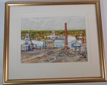 Bendigo Historical Society Inc.
Painting - JOHN HALL COLLECTION: HUSTLERS MINE
BHS CollectionWatercolour by John Hall of Hustler's Mine, Hustler's Hill, North Bendigo. Painting in gold frame, cream mount board. Painting shows a mine chimney and poppet heads on RH side, housing on left.John Hall, Eaglehawkbendigo, mining, hustler's mine -
 Whitehorse Historical Society Inc.
Photograph - ColouredPhotograph, Narmara Primary School, 13/01/1994 12:00:00 AM
Coloured photo of Narmara Primary School, looking North from south boundary. School on North side of Highbury Road between Middleborough Road and Blackburn Road. Since demolished and site developed for housing.narmara primary school, warner, philip -
![Newspaper Clipping - Digital Image, Dunvegan estate will be 'ideal' 1973 [Macleod], 21/08/1973](/media/collectors/4f729f5697f83e03086015b8/items/5eb3d35f21ea670b942b615e/item-media/5eb3d3bd21ea670b942bcc1d/item-fit-380x285.jpg) Greensborough Historical Society
Greensborough Historical SocietyNewspaper Clipping - Digital Image, Dunvegan estate will be 'ideal' 1973 [Macleod], 21/08/1973
In 1973, the planning for the Dunvegan Estate in North Macleod was well under way, with some residential blocks owned and developed by the Housing Commission of Victoria (later the Ministry of Housing).News clipping, black and white text.dunvegan estate macleod, north macleod, housing commission of victoria, ministry of housing victoria -
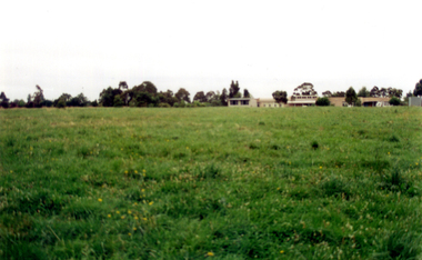
City of Kingston
Photograph - Colour, Circa 1993
Edithvale is a suburb in the City of Kingston. It is located between Aspendale and Chelsea on the Port Phillip Bay and built within remnant areas of the Carrum Carrum swamp. The foreshore precinct comprises a wide sandy beach, with low sand dunes and numerous historic boat sheds. The suburb consists of older style dwellings and former holiday houses, combined with mid-century housing and newer homes. The large blocks are increasingly subdivided and the existing dwellings demolished to accommodate units and townhouses, thus changing the landscape of the area and reducing the tree canopy.The beachside suburb of Edithvale was previously part of the extensive Carrum Carrum Swamp. The area was once a source of fish and eels for the Mayone-Bulluk clan of the Bunurong people. Over time the area was drained and predominantly devoted to dairy farming and holiday houses. The farms were gradually sold and subdivided with a large number of homes built after World War II and in the 1960s. Edithvale is mainly residential with a shopping strip along Nepean Highway but little significant industry was ever established in the area apart from a plaster works and confectionary factory, both now closed.Aerial colour photograph of Edithvale as viewed from Alexandra Avenue in the north to Ella Grove Chelsea/Edithvale in the south. The area is built-up with residential housing and facilities including Edithvale Primary School, numerous churches and the Edithvale Railway station. Large sections depict the remnant Carrum Carrum swamp. Edithvale Common and the former "Duck Inn" (Melbourne Water/Friends of Edithvale Seaford Wetlands) can be seen. Edithvale Recreational reserve, the velodrome and Edithvale Public Golf Course are prominent. The image shows vacant land in the area now known as Aspendale Gardens and the newer residential section of Chelsea Heights is not developed. A bike path has been established to cover the secondary drain. The Golf Links Court residential development located off Hughes Avenue is a large vacant block.Yellow circular adhesive sticker on plastic Black ink (marker): * (asterisk) Black type on white adhesive sticker: P000108edithvale, aspendale, chelsea, carrum carrum swamp -
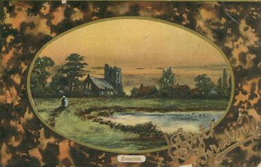 Bendigo Historical Society Inc.
Postcard - POSTCARD.OVAL FRAMED LANDSCAPE.BIRTHDAY GREETINGS
Postcard. Oval framed landscape with church to the left and other housing off centre right, Eventid. Birthday wishes. Two people walking a path to the left. Pond or dam to centre left. Rear. Names deleted. -
 Port Melbourne Historical & Preservation Society
Photograph - Princes Street, Port Melbourne, Geoff Cross, 1990
Panoramic view of Princes Street 1990. Shot by Princes Street resident Geoff Cross from the top of the Housing Commission flats. Originally combined from several shots, taken before the demolition of Bakery building.built environment, geoff cross, bakery building, princes street, housing commission of victoria flats -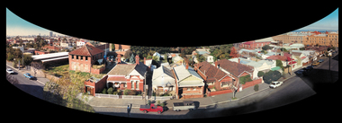
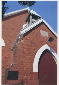 Uniting Church Archives - Synod of Victoria
Photograph, 2007
Colour photograph of the exterior of the Corryong U.C. including the AD 1895 foundation stone. The photograph shows a close up of the bell housing. A centenary plaque commemorates the construction of St. Andrew's church in 1895 by Thomas Greenhill.corryong u.c., st. andrew's presbyterian church corryong, thomas greenhill -
 Whitehorse Historical Society Inc.
Photograph - Coloured photograph, Narmara Primary School, 13/01/1994 12:00:00 AM
Coloured photo of Narmara Primary School Site, looking East from South East corner. North side of Highbury Road between Middleborough Road and Blackburn Road. Since demolished and site developed for housing.narmara primary school, warner, philip -
 Whitehorse Historical Society Inc.
Photograph - Coloured photograph, Narmara Primary School, 13/01/1994 12:00:00 AM
Coloured photo of Narmara Primary School, looking South from North West corner. School on North side of Highbury Road between Middleborough Road and Blackburn Road. Since demolished and site developed for housing.narmara primary school, warner, philip -
 Robin Boyd Foundation
Document - Manuscript, Robin Boyd, ("One of the few things.."), 1970
Discusses future cities and speculates on future trends. Looks back at ideas on the future of housing held by Boyd and his contemporaries in the 1950s and discusses how the reality of housing in the 1970s differs.Typewritten, quarto, 9 pagesfuture cities, apartments, suburban sprawl, modern houses, australian families, prefabrication, density, tensile construction, habitat 67, caravans, fred hoyle, tange, habitat 67, moomba, robin boyd, manuscript -
City of Kingston
Photograph - Black and white, 20 December 1945
This photograph depicts a section of Cheltenham with a mix of housing and market gardens. The visible market gardens, farms and paddocks have gradually been sub-divided into housing, commercial and industrial estates. A large part of Cheltenham was originally established as a rural market gardening community. The railway line and station brought urban development to the area and the gradual subdivision of farmland and large land holdings for the development of housing. Aerial photograph dated 1945 of the Cheltenham area in the City of Kingston. Sydney Street (bottom left); Sinclair Street (top left); Weymar Street area off Wilson Street, Charles Street (botton right).White print VIC-170; 57197; RUN5; PROJ.No.5; MELB.METROP AREA Lens information [indecipherable] Small photograph: clockface Black ink: 57197cheltenham, market gardens, urbanisation -
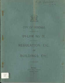 Bendigo Historical Society Inc.
Book - CITY OF BENDIGO BY-LAW NO 31 REGULATION OF BUIDLINGS ETC, 1916
City of Bendigo, By-Law No 31, regulation etc. of buildings etc. 51 pages. J.H. Curnow 21/12/16 written in top RH corner. Printed by Bolton Bros. BendigoCity of Bendigobendigo, housing, by-laws, bendigo, by-laws, history, housing -
 Queenscliffe Maritime Museum
Plan - Proposed option for housing for the QUEENSCLIFFE, Vacant Council Depot at Queenscliffe, unknown
Queenscliffe lifeboat housing optionOption to house the QUEENSCLIFFEPlan of vacant council depot proposed to house the QUEENSCLIFFE in 2-partsReverse - " nil ".historical references -
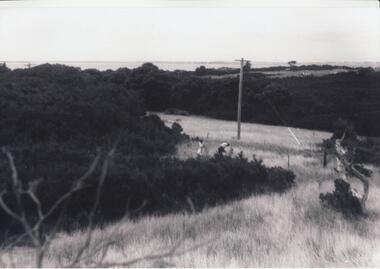 Phillip Island and District Historical Society Inc.
Photographs, Gary Field, 1963
Photographs taken by Gary Field. Lady in photos is Gary's mother. She planted Angophora trees near corner of Daffyd Street and Appley Avenue. (Information supplies by John Eddy).Four black & white photographs of panoramic views from and of Daffyd Street, Red Rocks in 1963, looking north with French Island and the Peninsula on the horizon, view of houses and caravans in Daffyd Street and showing local scrub and housing.daffyd street red rocks, red rocks phillip island, houses 1960's, gary field -
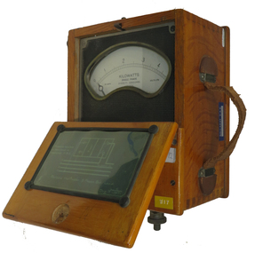 Federation University Historical Collection
Instrument - Electrical Instrument, Everett AC Wattmeter, 1923
Would have been used by staff and students of electrical Engineering at the School of Mines, Lydiard St. campus up until the start of the Mount Helen campus E building third floor. The meter would have had limited use in classes until 2009. This Wattmeter became part of the historical collection in 2011 after the movement of Engineering out of the E building. In working condition and a good example of early 20th century electrical instruments.A polished natural timber case with partial flip top lid and leather carry handle, housing a single phase AC Wattmeter, rated at 170 volts , 30 amps Scale 0 to 5 kilowatt. Serial no :210088Schematic diagram on inside lid showing how to connect the Wattmeter to measure a 3 phase balanced load. Paper sticker on top "1/92" Information for voltage and current ranges painted with white paint on left hand side by Voltage terminals Voltage terminals labelled A and N Also white on black "W8" on same surface Aluminium plate "67" on right hand side near current terminals which are engraved To A and Ti A to indicate current flow direction Aluminium sticker with Ballarat CAE Electrical Engineering by carry handleeverett instruments, single phase, wattmeter, electrical, scientific instruments -
Port Melbourne Historical & Preservation Society
Book, "The People of the Inner Urban Region. A Socio- demographic profile", Nov 1983
"The people of the Inner Urban Region. A socio-demographic profile" Detailed statistics under the major headings - the people of the region - the region's work force and the housing of inner urban residents of Melbourne; includes Port Melbourne . 1976 to 1981local government - city of port melbourne -
 Port Melbourne Historical & Preservation Society
Photograph - Excelsior Hall, Port Melbourne, Glen Stuart, 2003
Colour photos of early redevelopment of Excelsior Hall to become public housing. . from the corner of Bridge and Princes Streets June 2003 . from the corner of Bridge and Station Streets August 2003 . interior demolition August 2003built environment - domestic, built environment - civic, excelsior hall -
Port Melbourne Historical & Preservation Society
Photograph - Nomad aircraft at Fishermen's Bend, 1972
This Nomad, produced at the GAF, was the last official plane off the Fishermens Bend production line.Heavyweight colour lasercopy A3 size of an ASTA photo of Nomad aircraft showing government Aircraft Factory, West Gate Bridge under construction, beginnings of Webb Dock, piers, foreshore and Fishermens Bend housing c1972armed services - air force, industry - manufacturing, transport - aviation and aerodrome, fishermans bend, government aircraft factory -
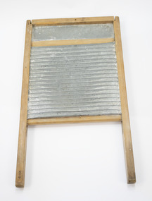 Clunes Museum
Domestic object - WASH BOARD
USED AS DESCRIBED ABOVEWOODEN WASH BOARD - WOODEN FRAME HOUSING RIPPLED METAL ONE SIDE, RIPPLED WOOD THE OTHER. SMALL LEDGE TO HOLD SOAP. WASH BOARD WAS SUPPORTED IN THE WASHING TUB WHILE LAUNDRESS RUBBED ITEMS TO BE LAUNDERED.local history, domestic, laundering, laundering -
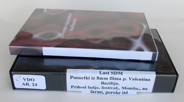 Slovenian Association Melbourne
Video and DVD, Footage of Slovenian migrants in 1956 in Australia, 1956
- Migrant ships arriving into Port Melbourne in 1956. Migrants boarding the train to Bonegilla camp and resettling in Victoria. - Section on Olympic Games in Melbourne was filmed by Father Basil Valentin OFM who was the Chaplain of the American Olympic team. -Also showed extracts of Moomba festival in 1957. - Slovenian settling on Australian farms and weddings of members of the Slovenian community This video shows the magnitude of migrants who arrived in Australia in 1956 by ships mainly from Italian ports from Genoa, Trieste and Naples. It shows the settling of migrants into camps and depicts their everyday life including education and recreation and assimilation into Australia. 120 minute video cassette in colour depicting migrant ships arriving to Port Melbourne in 1956 and short clips of the Melbourne Olympic Games. Also includes footage of train journey to Bonegilla camp and camp housing facility.0002migration, resettlement, bonegilla, slovenians, ships, olympics 1956