Showing 573 items
matching land surveyed
-
 St Kilda Historical Society
Photograph - Photo map, 11/01/1968
One of a series of photo-maps produced for the Department of Crown Lands and Survey (1857-1983). For correlation with a current map, and access to other historical photo maps of Victoria, see the Historic Photo-Maps Index published by the Department of Environment, Land, Water and Planning at https://services.land.vic.gov.au/DELWPmaps/historical-photomaps/Black and white aerial photographVic 2132 State Aerial Survey Melbourne 1968 Proj. Run 27E 11.1.68 5100 ASL 69st kilda, albert park, st kilda east, st kilda beach, alma park, windsor, prahran, 1968 -
 St Kilda Historical Society
Photograph - Photo map, 11/01/1968
One of a series of photo-maps produced for the Department of Crown Lands and Survey (1857-1983). For correlation with a current map, and access to other historical photo maps of Victoria, see the Historic Photo-Maps Index published by the Department of Environment, Land, Water and Planning at https://services.land.vic.gov.au/DELWPmaps/historical-photomaps/Black and white aerial photographVic 2132 State Aerial Survey Melbourne 1968 Proj. Run 28E 11.1.68 5100 ASL 81st kilda, balaclava, st kilda east, ripponlea, elwood, elsternwick, caulfield, st kilda botanical gardens, 1968 -
 St Kilda Historical Society
Photograph - Photo map, 11/01/1968
One of a series of photo-maps produced for the Department of Crown Lands and Survey (1857-1983). For correlation with a current map, and access to other historical photo maps of Victoria, see the Historic Photo-Maps Index published by the Department of Environment, Land, Water and Planning at https://services.land.vic.gov.au/DELWPmaps/historical-photomaps/Black and white aerial photographVic 2132 State Aerial Survey Melbourne 1968 Proj. Run 29E 11.1.68 5100 ASL 194elwood, elwood beach, elwood park, elsternwick park, ripponlea, elwood canal, balaclava, st kilda, 1968 -
 St Kilda Historical Society
Photograph - Photo map, 11/01/1968
One of a series of photo-maps produced for the Department of Crown Lands and Survey (1857-1983). For correlation with a current map, and access to other historical photo maps of Victoria, see the Historic Photo-Maps Index published by the Department of Environment, Land, Water and Planning at https://services.land.vic.gov.au/DELWPmaps/historical-photomaps/Black and white aerial photographVic 2132 State Aerial Survey Melbourne 1968 Proj. Run 27E 11.1.68 5100 ASLst kilda, st kilda west, st kilda pier, catani gardens, st kilda beach, albert park, 1968 -
 St Kilda Historical Society
Photograph - Photo map, 11/01/1968
One of a series of photo-maps produced for the Department of Crown Lands and Survey (1857-1983). For correlation with a current map, and access to other historical photo maps of Victoria, see the Historic Photo-Maps Index published by the Department of Environment, Land, Water and Planning at https://services.land.vic.gov.au/DELWPmaps/historical-photomaps/Black and white aerial photographVic 2132 State Aerial Survey Melbourne 1968 Proj. Run 29E 11.1.68 5100 ASL 196elwood, elwood park, elwood canal, elwood beach, st kilda marina, mc moran reserve, point ormond, 1968 -
 St Kilda Historical Society
Photograph - Photo map, Department of Crown Lands and Survey (1857-1983), 22/01/1970
One of a series of photo-maps produced for the Department of Crown Lands and Survey (1857-1983). For correlation with a current map, and access to other historical photo maps of Victoria, see the Historic Photo-Maps Index published by the Department of Environment, Land, Water and Planning at https://services.land.vic.gov.au/DELWPmaps/historical-photomaps/Black and white aerial photographVic 2358 Department of Crown Lands and Survey Victoria,.© Melbourne 1970 Project Run 41E 22.1.70 5,100 ASL 62caulfield, caulfield north, st kilda east, armadale, 1970 -
 St Kilda Historical Society
Photograph - Photo map, 14/12/1963
One of a series of photo-maps produced for the Department of Crown Lands and Survey (1857-1983). For correlation with a current map, and access to other historical photo maps of Victoria, see the Historic Photo-Maps Index published by the Department of Environment, Land, Water and Planning at https://services.land.vic.gov.au/DELWPmaps/historical-photomaps/Black and white aerial photographVic 1807 Melbourne 1963 Project Run 17 14.12.63 Lens 205 152.70 M/M 5.150 36st kilda, st kilda botanical gardens, balaclava, st kilda east, elwood canal, ripponlea, caulfield north, elwood, caulfield, 1963 -
 St Kilda Historical Society
Photograph - Photo map, Department of Crown Lands and Survey (1857-1983), 22/01/1970
One of a series of photo-maps produced for the Department of Crown Lands and Survey (1857-1983). For correlation with a current map, and access to other historical photo maps of Victoria, see the Historic Photo-Maps Index published by the Department of Environment, Land, Water and Planning at https://services.land.vic.gov.au/DELWPmaps/historical-photomaps/Black and white aerial photographVic 2358 Department of Crown Lands and Survey Victoria,.© Melbourne 1970 Project Run 42E 22.1.70 5,100 ASL 77st kilda, st kilda east, st kilda marina, elwood, elwood canal, elsternwick park, point ormond, balaclava, mc moran reserve, ripponlea, st kilda botanical gardens, peanut farm, 1970 -
 St Kilda Historical Society
Photograph - Photo map, Department of Crown Lands and Survey, 22/01/1970
One of a series of photo-maps produced for the Department of Crown Lands and Survey (1857-1983). For correlation with a current map, and access to other historical photo maps of Victoria, see the Historic Photo-Maps Index published by the Department of Environment, Land, Water and Planning at https://services.land.vic.gov.au/DELWPmaps/historical-photomaps/Black and white aerial photographVic 2358 Department of Crown Lands and Survey Victoria,.© Melbourne 1970 Project Run 43E 22.1.70 5,100 ASL 208elwood, elwood beach, point ormond, elwood park, elwood canal, mc moran reserve, 1970 -
 St Kilda Historical Society
Photograph - Photo map, Department of Crown Lands and Survey, 22/01/1970
One of a series of photo-maps produced for the Department of Crown Lands and Survey (1857-1983). For correlation with a current map, and access to other historical photo maps of Victoria, see the Historic Photo-Maps Index published by the Department of Environment, Land, Water and Planning at https://services.land.vic.gov.au/DELWPmaps/historical-photomaps/Black and white aerial photographCONTROLLED Vic 2358 Department of Crown Lands and Survey Victoria,.© Melbourne 1970 Project Run 41E 22.1.70 5,100 ASL 66st kilda, albert park, st kilda west, catani gardens, st kilda botanical gardens, st kilda pier, st kilda beach, 1970 -
 St Kilda Historical Society
Photograph - Photo map, Department of Crown Lands and Survey, 22/01/1970
One of a series of photo-maps produced for the Department of Crown Lands and Survey (1857-1983). For correlation with a current map, and access to other historical photo maps of Victoria, see the Historic Photo-Maps Index published by the Department of Environment, Land, Water and Planning at https://services.land.vic.gov.au/DELWPmaps/historical-photomaps/Black and white aerial photographVic 2358 Department of Crown Lands and Survey Victoria,.© Melbourne 1970 Project Run 42E 22.1.70 5,100 ASL 75st kilda, st kilda beach, st kilda marina, point ormond, st kilda pier, 1970 -
 St Kilda Historical Society
Photograph - Photo map, 14/12/1963
One of a series of photo-maps produced for the Department of Crown Lands and Survey (1857-1983). For correlation with a current map, and access to other historical photo maps of Victoria, see the Historic Photo-Maps Index published by the Department of Environment, Land, Water and Planning at https://services.land.vic.gov.au/DELWPmaps/historical-photomaps/Black and white aerial photographVic 1807 Melbourne 1963 Project Run 16 14.12.1963 Lens 205 152.70 M/M 5.150 177st kilda, st kilda pier, catani gardens, middle park, albert park, st kilda west, st kilda beach, 1963 -
 St Kilda Historical Society
Photograph - Photo map, Department of Crown Lands and Survey, 22/01/1970
One of a series of photo-maps produced for the Department of Crown Lands and Survey (1857-1983). For correlation with a current map, and access to other historical photo maps of Victoria, see the Historic Photo-Maps Index published by the Department of Environment, Land, Water and Planning at https://services.land.vic.gov.au/DELWPmaps/historical-photomaps/Black and white aerial photographVic 2358 Department of Crown Lands and Survey Victoria,.© Melbourne 1970 Project Run 41E 22.1.70 5,100 ASL 64st kilda, st kilda cemetery, balaclava, st kilda east, windsor, caulfield north, alma park, 1970 -
 St Kilda Historical Society
Photograph - Photo map, Department of Crown Lands and Survey, 08/01/1970
One of a series of photo-maps produced for the Department of Crown Lands and Survey (1857-1983). For correlation with a current map, and access to other historical photo maps of Victoria, see the Historic Photo-Maps Index published by the Department of Environment, Land, Water and Planning at https://services.land.vic.gov.au/DELWPmaps/historical-photomaps/Black and white arial photographVic 2345 Department of Crown Lands and Survey Victoria,.© Melbourne 1970 Project Run 40 8.1.70 5,100 ASL 77albert park, fawkner park, south yarra, middle park, prahran, windsor, st kilda, st kilda west, 1970 -
 St Kilda Historical Society
Photograph - Photo map, 22/01/1970
One of a series of photo-maps produced for the Department of Crown Lands and Survey (1857-1983). For correlation with a current map, and access to other historical photo maps of Victoria, see the Historic Photo-Maps Index published by the Department of Environment, Land, Water and Planning at https://services.land.vic.gov.au/DELWPmaps/historical-photomaps/Black and white aerial photographVic 2358 Department of Crown Lands and Survey Victoria,.© Melbourne 1970 Project Run 43E 22.1.70 5,100 ASL 206elwood, elsternwick, elsternwick park, 1970 -
 Clunes Museum
Document - LAND LICENCE
... OF LANDS AND SURVEY LAND ACT 1869 OCCUPATION BRANCH REVENUE OFFICE ....1 LICENCES FOR DEPARTMENT OF LANDS AND SURVEY - OCCUPATION BRANCH. LICENCE NO 315892 TO 315901. 25 FEBRUARY 1901 TO FEBRUARY 1902 STAPLED TOGETHER .2 LAND ACT 1869 SEC 20 BOOK 88. ON SPINE "THE CROWN - LAND ACT1869. SEC 20. 88 RECEIPTS FROM REVENUE OFFICE NO 2 TO 118 RECEIPTS 119 TO 249 HAVE NOT BEEN USED, THEY ARE CUT IN HALF.2 WHITE ROUND STICKER WITH "5" ON FRONTdepartment of lands and survey, land act 1869, occupation branch, revenue office -
Clunes Museum
Document - TIMBER LICENCE
... DEPARTMENT OF LAND AND SURVEY... LICENCE DEPARTMENT OF LAND AND SURVEY .2 ON FRONT A WHITE ROUND ....2 TWO PAGES OUT OF LICENCE BOOK 12 8TH APRIL 1903 TO HARVEST WOOD IN STATE FOREST IN CAMPBELLTOWN LICENCE EXPIRES 7 JULY 1903 .2 BOOK 375 NO 1 TO NO 24 TIMBER LICENCE ORDINARY WOOD, DATED 23 OCTOBER 1901 TO 29/07/1903.2 ON FRONT A WHITE ROUND STICKER WITH "16". ON THE BACK HANDWRITTEN 8/9/04timber licence, department of land and survey -
Tatura Irrigation & Wartime Camps Museum
Book, Warwick Finlay, The Doctor, The Captain, The Poet and Others, 2004
This book was printed to commemorate the 150th Anniversary of the survey, naming of the town and sale of land at Murchison.Black and white cover featuring the Goulburn River and portraits of Doctor McMillan, Captain John Murchison and Orion Horne over and early plan of Murchison Townshipmurchison -
Tatura Irrigation & Wartime Camps Museum
Map, Department of Land and Survey, County of Rodney
... Department of Land and Survey... of Rodney Map Department of Land and Survey ...Early county maps.One original map of County of Rodney and 3 photo copies. Original and one copy in colour. 2 copies in black and white. county of rodney -
Tatura Irrigation & Wartime Camps Museum
Book, Soils and Land Use, 1963
... Advice to land holders on how to use the Soil Survey Report... Survey Report. Soils and land use in the deakin Irrigation area ...Advice to land holders on how to use the Soil Survey Report. Soils and land use in the deakin Irrigation area, Vict, Technical Bulletin No. 16, Melb. Includes maps for Deakin Irrigation AreaCream cover, black writing, Techical Bulletin No. 16soils and land use, tatura, irrigation, books, technical, rural, industry -
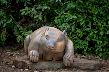 Hepburn Shire Council Art and Heritage Collection
Public Art Work, 'Wombat' - Miriam Porter. 2013, 2012 - 2013
Commissioned by the Friends of Wombat Hill Botanical Gardens and gifted to the Hepburn Shire in 2012. Historical Significance - In 1848, Irish immigrant John Egan took up land on the future town site then known as Wombat Flat. He and a party of searchers found alluvial gold in 1851 on ground now covered by Lake Daylesford initiating the local gold rush. Other finds quickly followed. With the finding of alluvial gold a town site was surveyed and founded in 1852. Initially called Wombat, it was renamed Daylesford. Cultural and Artistic Significance - Miriam Porter's 'Wombat' is a symbol of the Wombat Hill Botanical Gardens where visitors and locals alike love being photographed. Large scale solid redgum wombat sculpture.Artist intends to sign the work with 'M' on one leg.daylesford, hepburn shire, public art, miriam porter, wombat, art, sculpture, red gum, australian wood, australia, tourist attraction -
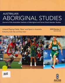 Victorian Aboriginal Corporation for Languages
Periodical, Australian Institute of Aboriginal and Torres Strait Islander Studies, Australian Aboriginal studies : journal of the Australian Institute of Aboriginal and Torres Strait Islander Studies, 2009
Darkness and a little light: ?Race? and sport in Australia Colin Tatz (AIATSIS & Australian National University) and Daryl Adair (University of Technology Sydney) Despite ?the wonderful and chaotic universe of clashing colors, temperaments and emotions, of brave deeds against odds seemingly insuperable?, sport is mixed with ?mean and shameful acts of pure skullduggery?, villainy, cowardice, depravity, rapaciousness and malice. Thus wrote celebrated American novelist Paul Gallico on the eve of the Second World War (Gallico 1938 [1988]:9-10). An acute enough observation about society in general, his farewell to sports writing also captures the ?clashing colors? in Australian sport. In this ?land of the fair go?, we look at the malice of racism in the arenas where, as custom might have it, one would least want or expect to find it. The history of the connection between sport, race and society - the long past, the recent past and the social present - is commonly dark and ugly but some light and decency are just becoming visible. Coming to terms: ?Race?, ethnicity, identity and Aboriginality in sport Colin Tatz (AIATSIS & Australian National University) Notions of genetic superiority have led to some of the world?s greatest human calamities. Just as social scientists thought that racial anthropology and biology had ended with the cataclysm of the Second World War, so some influential researchers and sports commentators have rekindled the pre-war debate about the muscular merits of ?races? in a new discipline that Nyborg (1994) calls the ?science of physicology?. The more recent realm of racial ?athletic genes?, especially within socially constructed black athletic communities, may intend no malice but this search for the keys to their success may well revive the old, discredited discourses. This critical commentary shows what can happen when some population geneticists and sports writers ignore history and when medical, biological and sporting doctrines deriving from ?race? are dislocated from any historical, geographic, cultural and social contexts. Understanding discourses about race, racism, ethnicity, otherness, identity and Aboriginality are essential if sense, or nonsense, is to be made of genetic/racial ?explanations? of sporting excellence. Between the two major wars boxing was, disproportionately, a Jewish sport; Kenyans and Ethiopians now ?own? middle- and long-distance running and Jamaicans the shorter events; South Koreans dominate women?s professional golf. This essay explores the various explanations put forward for such ?statistical domination?: genes, biochemistry, biomechanics, history, culture, social dynamics, the search for identity, alienation, need, chance, circumstances, and personal bent or aptitude. Traditional games of a timeless land: Play cultures in Aboriginal and Torres Strait Islander communities Ken Edwards (University of Southern Queensland) Sports history in Australia has focused almost entirely on modern, Eurocentric sports and has therefore largely ignored the multitude of unique pre- European games that are, or once were, played. The area of traditional games, especially those of Aboriginal and Torres Strait Islander peoples, is an important aspect of the cultural, social and historical experiences of Indigenous communities. These activities include customs of play that are normally not associated with European notions of competitive sport. Overall, this paper surveys research undertaken into traditional games among Indigenous Australians, as well as proposals for much needed further study in this area. Culture, ?race? and discrimination in the 1868 Aboriginal cricket tour of England David Sampson As a consequence of John Mulvaney?s important historical research, the Aboriginal cricket and performance tour of Britain in 1868 has in recent decades become established as perhaps the most famous of all public events in contact history involving Aborigines, white settlers and the British metropolis. Although recognition of its importance is welcome and significant, public commemorations of the tour have enveloped the tour in mythologies of cricket and nation. Such mythologies have obscured fundamental aspects of the tour that were inescapable racial and colonial realities of the Victorian era. This reappraisal of the tour explores the centrality of racial ideology, racial science and racial power imbalances that enabled, created and shaped the tour. By exploring beyond cricketing mythology, it restores the central importance of the spectacular performances of Aboriginal skills without which the tour would have been impossible. Such a reappraisal seeks to fully recognise the often trivialised non-cricketing expertise of all of the Aboriginal performers in 1868 for their achievement of pioneering their unique culture, skills and technologies to a mass international audience. Football, ?race? and resistance: The Darwin Football League, 1926?29 Matthew Stephen (Northern Territory Archive Service) Darwin was a diverse but deeply divided society in the early twentieth century. The Commonwealth Government introduced the Aboriginals Ordinance 1911 in the Northern Territory, instituting state surveillance, control and a racially segregated hierarchy of whites foremost, then Asians, ?Coloureds? (Aborigines and others of mixed descent) and, lastly, the so-called ?full-blood? Aborigines. Sport was important in scaffolding this stratification. Whites believed that sport was their private domain and strictly controlled non-white participation. Australian Rules football, established in Darwin from 1916, was the first sport in which ?Coloured? sportsmen challenged this domination. Football became a battleground for recognition, rights and identity for all groups. The ?Coloured? community embraced its team, Vesteys, which dominated the Northern Territory Football League (NTFL) in the 1920s. In 1926, amidst growing racial tension, the white-administered NTFL changed its constitution to exclude non-white players. In reaction, ?Coloured? and Chinese footballers formed their own competition - the Darwin Football League (DFL). The saga of that colour bar is an important chapter in Australia?s football history, yet it has faded from Darwin?s social memory and is almost unknown among historians. That picture - Nicky Winmar and the history of an image Matthew Klugman (Victoria University) and Gary Osmond (The University of Queensland) In April 1993 Australian Rules footballer Nicky Winmar responded to on-field racist abuse by lifting his jersey and pointing to his chest. The photographic image of that event is now famous as a response to racial abuse and has come to be seen as starting a movement against racism in football. The racial connotations in the image might seem a foregone conclusion: the power, appeal and dominant meaning of the photograph might appear to be self-evident. But neither the fame of the image nor its racial connotation was automatic. Through interviews with the photographers and analysis of the use of the image in the media, we explore how that picture came to be of such symbolic importance, and how it has remained something to be re-shown and emulated. Rather than analyse the image as a photograph or work of art, we uncover some of its early history and explore the debates that continue to swirl around its purpose and meaning. We also draw attention to the way the careful study of photographs might enhance the study of sport, race and racism. ?She?s not one of us?: Cathy Freeman and the place of Aboriginal people in Australian national culture Toni Bruce (University of Waikato) and Emma Wensing (Independent scholar) The Sydney 2000 Olympic Games generated a national media celebration of Aboriginal 400 metre runner Cathy Freeman. The construction of Freeman as the symbol of national reconciliation was evident in print and on television, the Internet and radio. In contrast to this celebration of Freeman, the letters to the editor sections of 11 major newspapers became sites for competing claims over what constitutes Australian identity and the place of Aboriginal people in national culture. We analyse this under-explored medium of opinion and discuss how the deep feelings evident in these letters, and the often vitriolic responses to them, illustrate some of the enduring racial tensions in Australian society. Sport, physical activity and urban Indigenous young people Alison Nelson (The University of Queensland) This paper challenges some of the commonly held assumptions and ?knowledges? about Indigenous young people and their engagement in physical activity. These include their ?natural? ability, and the use of sport as a panacea for health, education and behavioural issues. Data is presented from qualitative research undertaken with a group of 14 urban Indigenous young people with a view to ?speaking back? to these commentaries. This research draws on Critical Race Theory in order to make visible the taken-for-granted assumptions about Indigenous Australians made by the dominant white, Western culture. Multiple, shifting and complex identities were expressed in the young people?s articulation of the place and meaning of sport and physical activity in their lives. They both engaged in, and resisted, dominant Western discourses regarding representations of Indigenous people in sport. The paper gives voice to these young people in an attempt to disrupt and subvert hegemonic discourses. An unwanted corroboree: The politics of the New South Wales Aboriginal Rugby League Knockout Heidi Norman (University of Technology Sydney) The annual New South Wales Aboriginal Rugby League Knockout is so much more than a sporting event. Involving a high level of organisation, it is both a social and cultural coming together of diverse communities for a social and cultural experience considered ?bigger than Christmas?. As if the planning and logistics were not difficult enough, the rotating-venue Knockout has been beset, especially since the late 1980s and 1990s, by layers of opposition and open hostility based on ?race?: from country town newspapers, local town and shire councils, local business houses and, inevitably, the local police. A few towns have welcomed the event, seeing economic advantage and community good will for all. Commonly, the Aboriginal ?influx? of visitors and players - people perceived as ?strangers?, ?outsiders?, ?non-taxpayers? - provoked public fear about crime waves, violence and physical safety, requiring heavy policing. Without exception, these racist expectations were shown to be totally unfounded. Research report: Recent advances in digital audio recorder technology provide considerable advantages in terms of cost and portability for language workers.b&w photographs, colour photographs, tablessport and race, racism, cathy freeman, nicky winmar, rugby league, afl, athletics, cricket, digital audio recorders -
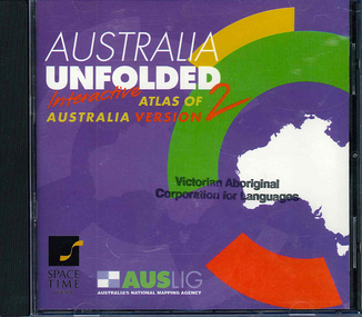 Victorian Aboriginal Corporation for Languages
CD-ROM, Australian Surveying and Land Information Group, Australia unfolded : interactive atlas of Australia, 1996
... of Australia CD-ROM Australian Surveying and Land Information Group ...Systems requirements: Macintosh version: Mac Plus (68030 or higher recommended), 5 MB hard disk space, 2 MB RAM (4 MB RAM recommended), CD-ROM drive, mouse, System 7 or above. "9314231106006"--CD-ROM. System requirements: Windows version: IBM compatible 386 or higher, 5MB hard disk space, 4MB RAM (8MB RAM recommended), VGA monitor, CD-ROM drive, mouse, Windows 3.1 or above. In box (19 x 27 x 5 cm.).CD-ROMtopographic maps, australian maps, surveying -
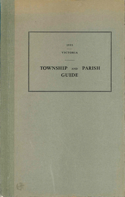 Victorian Aboriginal Corporation for Languages
Book, Department of Crown Lands and Survey Victoria, Township and parish guide : Victoria, 1955
A alphabetical list of townships proclaimed under the Land Acts of Victoria. Shows the parish, land district and the municipality in which each is situated, and the particulars of Gazettal of Proclamation.victorian geographical names, victorian administration -
University of Melbourne, Burnley Campus Archives
Document, [Notes on early history of Burnley land], 1857
Copies of letters re Survey paddock, roads, etc. Refer to paper catalogueburnley, survey paddock -
Lakes Entrance Regional Historical Society (operating as Lakes Entrance History Centre & Museum)
Book, Marjorie Morgan, Captain Slades Census 1853 Tarraville and Alberton, 1987
... Entrance gippsland Settlers Surveying Land Settlement Fasimile ...Fasimile reproduction of Victorian Government records giving valuation of Crown Lands under Pre emptive right originally printed in sixteen counties and four districts are included.settlers, surveying, land settlement -
Lakes Entrance Regional Historical Society (operating as Lakes Entrance History Centre & Museum)
Photograph, 1900 c
On baqck of original Raymond Island Tambo River in distance. This survey lookout has been washed away, seawater has killed vegetation and allowed erosionBlack and white photograph of a timber beacon on land in Gippsland Lakes in vacinity of Raymond Island Victoriaboats and boating, competitions, celebrations -
Clunes Museum
Document - LEASE
LICENCE ISSUED TO MR. PATRICK KEIRCE [INCORRECT SPELLING KIERCE] ON 29TH AUGUST 1870PHOTOCOPY OF LEASE OF LANDASSISTANT COMMISSIONER OF LANDS AND SURVEY. BALLARAT.local history, document, lease, kierce, michael mr. -
Clunes Museum
Book, DEPARTMENT OF LAND AND SURVEY, LICENCE
... DEPARTMENT OF LAND AND SURVEY... - 124130 LICENCE Book BOOK DEPARTMENT OF LAND AND SURVEY ...RECEIPTS ISSUED TO CUSTOMER DENOTING LOCALITY TO SPLIT AND TAKE AWAY EUCALYPTUS TIMBER FROM BUSH. LICENCES ISSUED PER QUARTER.BLUE CARDBOARD COVERED BOOK CONTAINING TIMBER LICENSE FOR ORDINARY WOOD ISSUED SEPTEMBER 1884 TO OCTOBER 1892. RECEIPT NUMBERS 124121 - 124130ON FRONT COVER: TIMBER LICENSE ORDINARY WOOD 50/- NO.1 EXHAUSED AFTER AUDIT 23-8-92local history, book, licence, receipt, timber licence -
Clunes Museum
Administrative record - BOOK, DEPARTMENT OF LAND AND SURVEY, LICENCE
... DEPARTMENT OF LAND AND SURVEY... record BOOK DEPARTMENT OF LAND AND SURVEY TIMBER LICENCE ORDINARY ...RECEIPTS ISSUED BY DEPARTMENT OF LANDS AND SURVEY TO CUT AND TAKE AWAY WOOD. ISSUED EACH QUARTER. LOCALITY - ALL CROWN LANDS, NOT BEING IN STATE FORESTS OR RESERVES FOR ANY SPECIAL PURPOSE. GUM, STRINGYBARK, BOX, MESSMATE AND OTHER KINDS OF EUCALYPTUS TIMBER EXCEPTING RED GUM AND IRON BARK.BLUE CARDBOARD COVERED BOOK CONTAINING TIMBER LICENCES FOR ORDINARY WOOD, COSTING 5/- .1 ISSUED 1886 - 1887 RECEIPT NUMBERS 181901 - 181925 .2 ISSUED 1885 - 1886 RECEIPT NUMBERS 185276 - 185300 DETAILS OF NAMES OF PERSONS LICENCES ISSUED TO ATTACHED TO BACK OF BOOKSlocal history, receipt books, early citizens, wood licences