Showing 407 items matching "language maps"
-
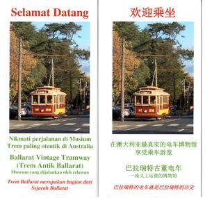 Ballarat Tramway Museum
Pamphlet, Warren Doubleday, "Welcome Aboard", Dec. 2019
Set of four Printed colour foreign language versions of BTM "Welcome Aboard" pamphlets for handing out to passengers on trams. Features photos of 26, 38, 1 & 14 and interior photo ex 26 and text describing "Your Trip", the trams, Ballarat Tramways, and the museum itself and has maps of the Ballarat system and the Gardens area. See Reg. items 712 and 1532 for details of earlier productions. Item folded as presented to a passenger or picked up at the depot. 250 each printed 12/2019 by Waller and Chester. .1 - Korean version .2 - Japanese version .3 - Indonesian version .4 - Chinese version Work by etranslate, Pamela Lee, March 2016. When checked 26/12/2019 - now part of Transperfect, with a Sydney office. Word and pdf versions of the items are stored on the website server - 8-1-2020. trams, tramways, btm, handouts, passengers, pamphlets, foreign language -
 Federation University Art Collection
Painting - Acrylic on Linen, 'Tingari Cycle' by Walala Tjapaltjarri
Walala Tjapaltjarri (b. c1960) Language: Pintupi Region: Kiwirrkuru In late 1984 Walala Tjapaltjarri and several other members of the Pintupi Tribe walked out of the remote wilderness of the Gibson Desert in Western Australia and made contact for the first time with European society. Described as 'The Lost Tribe', he and his family created international headlines. Until that day in 1984, Walala and his family lived the traditional and nomadic life of a hunter-gatherer society. Their intimate knowledge of the land, its flora and fauna and waterholes allowed them to survive, as their ancestors had for thousands of years. It is this sacred landscape, and its significant sites, that Walala so strikingly describes in his paintings. His style is generally highlighted by a series of rectangles set against a monochrome background. He paints the Tingari Cycle (a series of sacred and secret mythological song cycles) which are associated with the artist's many dreaming sites - they are Wilkinkarra, Maruwa, Tarrku, Njami and Yarrawangu, to name a few. These Dreamings are the locations of significant rockholes, sandhills, sacred mountains and water soakages in the Gibson Desert. (http://www.kateowengallery.com/artists/Wal90/Walala-Tjapaltjarri.htm, accessed 18 May 2015) Walala Tjapaltjarri started painting in 1997. His earliest works were in a classical Tingari style usually reserved for body painting, ground painting and the decoration of traditional artifacts. Within a couple of months his painting had evolved into his own innovative style of work, including the abstraction of classical Pintupi designs which resulted in a highly graphic language to speak of his country and ceremonial sites. The rectangles so prominent in his paintings form both a physical and spiritual map establishing Walala as a discerning draughtsman for his ancient country. (http://www.kateowengallery.com/artists/Wal90/Walala-Tjapaltjarri.htm, accessed 18 May 2015) This item is part of the Federation University Art Collection. The Art Collection features over 1000 works and was listed as a 'Ballarat Treasure' in 2007.Tingari Cycle - During the Tjukurrpa (Creation Era) Tingari ancestors beings gathered at a series of sites for Malliera (Initiation) Ceremonies. They travelled vast stretches of the country, performing rituals at specific sites that in turn created the diverse natural features of the environment. The Tingari men were accompanied by novices and usually followed by Tingari Women. The creation stories and rituals are venerated in the song cycles and ceremonies of today, forming part of the teachings of the post initiatory youths, whilst also providing explanations for contemporary customs. Walala Tjapaltjarri uses a highly personalised and minimal style to represent aspects of the sacred Tingari Cycle, an epic journey of Ancestors of the TJukurrpa (Creation Era). He paints aspects of the Tingari Cycle which are associated with the artist's many sacred sites - such as Wilkinkarra, Maruwa, Tarrku, Njami and Yarrawangu, to name a few. These are locations of significant rockholes, sandhills, sacred mountains and water soakages in the Gibson Desert. (http://www.kateowengallery.com/artists/Wal90/Walala-Tjapaltjarri.htm, accessed 18 May 2015)art, artwork, walala tjapaltjarri, aboriginal, dreaming, creation era, acrylic on linen, pintupi, kiwirrkuru, tingari, wilkinkarra, tarrku, njami, yarrawangu -
 The Celtic Club
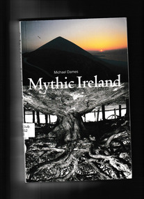
Book, Michael Dames, Mythic Ireland, 1992
Ireland, more than any other country in Europe, has retained its mythological heritage, which lives today in the oral tradition of folk tales, in literature, in place-names and language, in ceremonies and monuments. Mountains and loughs are the homes of gods and goddesses, of saints and monsters, and pattern, beauty and cyclical logic are revealed in their stories. Michael Dames, whose previous works have won him a wide and enthusiastic following, has walked through each.Index, bib,notes, maps, plates, ill, p.258.non-fictionIreland, more than any other country in Europe, has retained its mythological heritage, which lives today in the oral tradition of folk tales, in literature, in place-names and language, in ceremonies and monuments. Mountains and loughs are the homes of gods and goddesses, of saints and monsters, and pattern, beauty and cyclical logic are revealed in their stories. Michael Dames, whose previous works have won him a wide and enthusiastic following, has walked through each.1. spirituality, 2. irish myths. -
 The Celtic Club
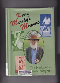
Book, Kerry Murphy, Kerry Murphy's Memoirs: The diaries of an Irish immigrant, 1998
Based on meticulously-kept diaries, this book represents a compelling narrative of a man passionate about all things Gaelic - hurling, Gaelic football, language, religion, politics, dance and the celebration of St Patrick's Day.Index, bib., tables, maps, plates. p.320.non-fictionBased on meticulously-kept diaries, this book represents a compelling narrative of a man passionate about all things Gaelic - hurling, Gaelic football, language, religion, politics, dance and the celebration of St Patrick's Day.australia - hstory 1788-1900, convicts - australia -
 The Celtic Club
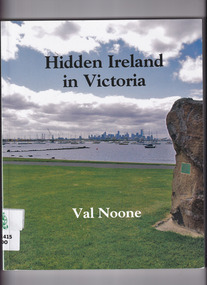
Book, Val Noone, Hidden Ireland in Victoria, 2012
This book is about songs, stories, poems, prayers and accents - as well as events and monuments - of those whose original language was Irish. A first ever history of the Irish language and Gaelic culture in Victoria.Index, bib., ill, map, p.215.non-fictionThis book is about songs, stories, poems, prayers and accents - as well as events and monuments - of those whose original language was Irish. A first ever history of the Irish language and Gaelic culture in Victoria.victoria - social life and customs., irish- victoria - history. -
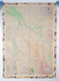 Woodend RSL
Map, Afghanistan South Western Oruzgan Helmad and Kandahar Province’s July 2009, September 2009
Map was used by Alan Mitchell-Lapin during patrols with Commando Regiment. Alan Mitchell-Lapin is a resident of Woodend.Alan Mitchell-Lappin is a member of the Woodend RSL who served with the Commandos in Afghanistan. Alan was awarded a Commendation for Gallantry for his service in Afghanistan. The map was utilised by Alan during his patrols.Patrol map for South Western Orguzgan Helmand and Kandahar Province’s. Scale 1:200,000. Produced by Australian Government Department of Defence Intelligence and Security. Table top right -Military Legend. Tables middle right - Language distribution, and translation glossary. Table bottom right hand corner - Topograhic Legend. Table centre bottom - Grid magnetic Diagrams. Table top left corner - Tarwin Kowt weather infromation.Produced by the Defence Imagery and Geospatial Organisation, Geospatial Analysis Centre, September 2009. Restricted at time of issue.afghanistan, map, orguzgan, helmand, kandahar, operation slipper, mitchell-lapin, 2009, digo 0098-0910, commando, special forces -
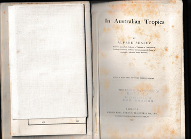 Mrs Aeneas Gunn Memorial Library
Book, Kegan Paul Trench Trubner and Co, In Australian tropics, 1907
Early history of N.T. and explorations; Detailed account of intercepting Macassan proas around coast of Arnhem Land whilst author was Sub-Collector of Customs for 14 years; Names of proas and masters, Malay camps & smoke houses along coast & nearby islands; Natives employed by Malays in trepang fishing and collecting tortoiseshell, relationships between Malays and Aborigines; influences (physical & cultural); Habit of exchanging children between tribes (Roper R. & Normanton) for the purpose of learning each others language & customs; Description of native camps at Fort Dundas (1895) shelters, finding of bark water bags, types of canoes used; Platform burial at Daly R.; Sacred burial site on Maria Island; Geographical features, vegetation, climate etc., general ecology, depredations & murders by natives; Cannibalism practiced by Fitzmaurice River tribes.Ill, maps, p.373.non-fictionEarly history of N.T. and explorations; Detailed account of intercepting Macassan proas around coast of Arnhem Land whilst author was Sub-Collector of Customs for 14 years; Names of proas and masters, Malay camps & smoke houses along coast & nearby islands; Natives employed by Malays in trepang fishing and collecting tortoiseshell, relationships between Malays and Aborigines; influences (physical & cultural); Habit of exchanging children between tribes (Roper R. & Normanton) for the purpose of learning each others language & customs; Description of native camps at Fort Dundas (1895) shelters, finding of bark water bags, types of canoes used; Platform burial at Daly R.; Sacred burial site on Maria Island; Geographical features, vegetation, climate etc., general ecology, depredations & murders by natives; Cannibalism practiced by Fitzmaurice River tribes. northern australia - description and travel, ethnography -
 City of Kingston
Map - Parish of Moorabbin
Warning: This object includes historical language referring to First Nations Peoples which is no longer appropriate but has been recorded for historical purposes. Produced in 1853, this map shows the land holdings of European families. While the majority of holdings are small there are also large land holdings as can be seen with Henry Dendy's Special Survey. Of particular note is the "Reserve for Aborigines" which was established in approximately 1841 and consisted of over 830 acres. This area is the current location of Mordialloc township and Attenborough Park, in Mordialloc, is the last remnant of the reserve. An Alfred Sikes, possibly the surveyor/cartographer who drew this parish plan, purchased land in Berwick in 1854.A handrawn map on fabric, with blue markings representing the coastline to Port Phillip Bay, red markings representing a proposed train line to Mordialloc, major roads and street, as well as a "Reserve for Aborigines", which constituted approximately 830 acres. In the bottom right hand corner, the map has been signed and dated.Handwritten in ink: Alfred Sikes / 38 Collins St East / June. 1853moorabbin, mordialloc, dendy, port phillip bay, aboriginal reserve, attenborough park -
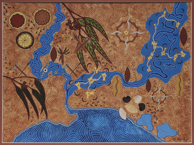 Merri-bek City Council
Acrylic on watercolour paper, Mandy Nicholson, Cultural Map of Melbourne, 2003
Primarily a painter, Mandy Nicholson also produces ceramics, carvings, murals, prints, designs and children’s clothing. Born in 1975, Nicholson was raised in Healesville and belongs to the Wurundjeri-willam (Woiwurrung language) clan of the Kulin Nation. Mandy’s paintings often represent important cultural rituals and are executed in her distinct graphic style using the traditional motifs of her people blended with contemporary interpretation. Cultural Map of Melbourne shows significant sites across Melbourne. These include scar trees, corroboree trees, stone quarries, bush tucker sites, significant rivers, fresh water wells and traditional campsites. -
 Bendigo Historical Society Inc.
Book - STRAUCH COLLECTION: WESTGARTHTOWN
BHS CollectionWhite 3 ring binder contains information on Westgarthtown,Tatura german heritage trail with illustrations, photographs and maps, mostly written in German language.victoria, history, german, history-victoria-german-westgarthtown-tatura -
 Melbourne Tram Museum
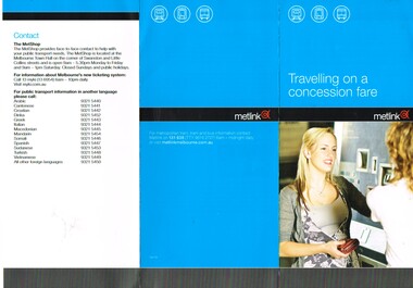
Pamphlet, Metlink, "Travelling on a concession fare" "Public Transport Fares Guide", Dec. 2009
Set of two DL pamphlets issued by Metlink. .1 - Three fold, titled "Travelling on a concession fare", issued Dec. 09, with images of allowable concession cards, notes travelling on both Metcards and Myki. Has contact details, languages and Metlink logos. .2 - Twelve page + cover with fold out maps of the CBD city save section, Metro trains and tram system titled "Public Transport Fares Guide". Centre stapled. Dated Sept. 2011, has Metlink logos.trams, tramways, fares, tickets, metlink, metcard, concession fares, public transport -
 Melbourne Tram Museum
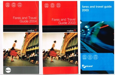
Pamphlet, Metlink, "Fares and Travel Guide", 2003 to 2008
Set of nine "Fares and Travel Guide" for years 2003 (2 issues) to 2008. Each have contact details, and maps of the tram and train systems of Melbourne. Details fares, Metcard products, buying and validating Metcards, concession cards, refunds, travelling with pets, surfboards, general info. .1 - 2003 - Pamphlet - DL size, blue coloured covers six fold full colour printed on gloss paper, with details of operators - M>Train, Connex, M>Tram, Yarra trams - early 2003. .2 - 2003 - Pamphlet - DL size, red coloured covers six fold full colour printed on gloss paper, with details of operators - M>Train, Connex, M>Tram, Yarra trams - late 2003. .3 - 2004 - Pamphlet - DL size, red coloured covers six fold full colour printed on gloss paper, with details of operators - Yarra trams and Connex Trains. .4 - 2005 - Pamphlet - DL size, red coloured covers six fold full colour printed on gloss paper, with details of operators - Yarra trams and Connex Trains. Dated Jan. 2005. .5 - 2006 - Book - DL size, red coloured covers 20 pages, centre stapled, colour printed on gloss paper with fold out map, has index, ticket guides and other details about the Melbourne transport system. Dated Jan. 2006. .6 - 2007 - Book - DL size, red coloured covers 24 pages, centre stapled, colour printed on gloss paper with fold out map, has index, ticket guides and other details about the Melbourne transport system. Dated Jan. 2007. .7 - 2007 - June - as for .6 .8 - 2008 - January 2008 - as for .6, with D1 3510 and Flinders St station on front cover. (.7 added 16-11-2015 and .8 added 16-8-2017) .9 added - as for .5, but dated Feb. 2006. - added 8/7/2018. .10 - 2010 - 32 pages, red cover with an C2 class at Southern Cross station, etc - added 19/11/2020 See 2476.1 > 2476.4 for 2009 copy and another three languages. See 2328 for a 2011 copy. See 2393 for a 2013 copy. See 2507 for 2000 and 2001 copies.trams, tramways, tickets, fares, connex, m>tram, m>train, yarra trams, guides -
 Melbourne Tram Museum
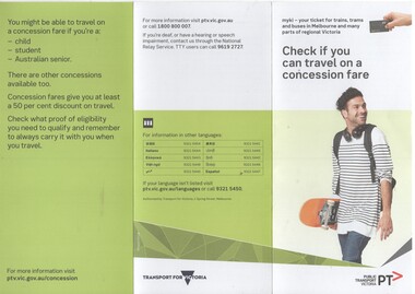
Pamphlet, Public Transport Victoria (PTV), "Check if you can travel on a concession fare", late 2017 to 4/19
.1 - Three fold, DL titled "Check if you can travel on a concession fare", issued late 2017 early 2018 with images of allowable concession cards, including senior and other concession card. ..2 - Five fold DL titled "Your go-to guide to myki" explaining the Myki system costs, types, the Explorer pack for visitors and has a map of the CBD Free Tram Zone. .3 - two fold DL titled "Explore the Night" giving details of night services for trains, trams, bus and coaches. .4 - three fold DL update of .1, issued April 19. Has contact details, languages and Transport for Victoria logo with PTV web address. Printed on recycled paper.trams, tramways, fares, tickets, myki, concession fares, public transport, free tram, night trams -
 Melbourne Tram Museum
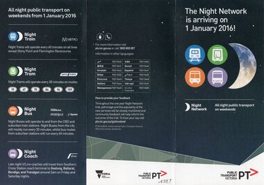
Pamphlet, Public Transport Victoria (PTV), "The night network is arriving on 1 January 2016", late 2015
Pamphlet - 3 fold DL titled "The night network is arriving on 1 January 2016", giving details of the night services on trains, trams, buses and coaches. Has a diagrammatic map of services. Provides contact details, language phone numbers. Published late 2015, Two copies held.trams, tramways, night trams, public transport, ptv, buses, railways, all night services -
 Bendigo Historical Society Inc.
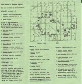
Document - BENDIGO CEMETERIES COLLECTION: SELF GUIDED TOUR NO. 4 DOCUMENT
BHS CollectionGreen trifold document: Self Guided Tour No. 4 of the Bendigo Cemetery, Friends of the Bendigo Cemeteries 1997. Map of Bendigo Cemetery with numbered grave sites. Theme : National and religious diversity. Text on back describes how early colonists arrived with different religions, languages, social habits etc Sandhurst Cemetery Register recorded denomination not nationality, but noted if the dead person was coloured.Friends of the Bendigo Cemeteries Inc 1997bendigo, cemetery, bendigo cemetery tour -
 Mont De Lancey
Book, Rev. John Brown, Brown's Self-Interpreting Family Bible, late 1800's
Illustrated late Victorian family Bible— the beloved King James text, augmented by the late Revd John Brown of Haddington’s comprehensive Bible study aids— with a total of 36 plates (25 in color) handsomely bound. First published in 1611, the King James Version of the Bible has exercised an incalculable impact on piety, language and literature throughout the English-speaking world. "Other translations may engage the mind, but the King James Version is the Bible of the heart" (Campbell, 275). It is probably the text most commonly found in decorative family Bibles such as this one, which has a total of 36 plates, including an engraved title page, a 12-page family register, the Lord's Prayer, two maps and nine other plates all printed in color. The Rev. John Brown of Haddington was "a tirelessly faithful pastor"—"For eight months of the year he delivered a lecture, two sermons, and an exercise each Sunday"—and also a prolific author. He is best remembered for his Self-Interpreting Bible, first published 1778, which became "as familiar in Presbyterian households as John Bunyan's Pilgrim's Progress and Thomas Boston's Human Nature in its Fourfold State" (DNB). Without Apocrypha. After page 302 at the end of the Old Testament is a highly colourful and decorative page of 'The Lord's Prayer' after which is a separate New Testament title page.Brown's Self-Interpreting Family Bible. London: John G. Murdoch, circa 1875. Thick folio, full dark brown morocco, beveled edges, all edges gilt, brass trim, clasps and catches. The title, Holy Bible is printed in an indented star shaped decorative surround, around the edges of the letters in the middle of the front cover. The spine has four bands across it with Holy Bible printed in gold lettering at the top. The beautifully coloured Title Page is very decorative all over with tan, pale green, dark green and white patterns. Opposite is a black and white plate depicting Moses in his basket in the bulrushes with his mother hiding behind him. There is a plain black and white title page too with full details, including publisher and other details. At the front, information about the Reverend John Brown is included over several pages as well as details of his Monument Inscription in Haddington Churchyard 19th June A.D. 1787, aged 65 years. Following this is an Introduction to the Right Understanding of the Oracles of God. There are many black and white, plus coloured plates included throughout the Bible. Pp. 1123 (Bible) At the back are many additional inclusions: Alphabetical Index, A Collection of names given to Jesus Christ and others, The Psalms of David in Metre, Hymns and Passages of Scripture Paraphrased. In all a most complex Bible for the family.non-fictionIllustrated late Victorian family Bible— the beloved King James text, augmented by the late Revd John Brown of Haddington’s comprehensive Bible study aids— with a total of 36 plates (25 in color) handsomely bound. First published in 1611, the King James Version of the Bible has exercised an incalculable impact on piety, language and literature throughout the English-speaking world. "Other translations may engage the mind, but the King James Version is the Bible of the heart" (Campbell, 275). It is probably the text most commonly found in decorative family Bibles such as this one, which has a total of 36 plates, including an engraved title page, a 12-page family register, the Lord's Prayer, two maps and nine other plates all printed in color. The Rev. John Brown of Haddington was "a tirelessly faithful pastor"—"For eight months of the year he delivered a lecture, two sermons, and an exercise each Sunday"—and also a prolific author. He is best remembered for his Self-Interpreting Bible, first published 1778, which became "as familiar in Presbyterian households as John Bunyan's Pilgrim's Progress and Thomas Boston's Human Nature in its Fourfold State" (DNB). Without Apocrypha. After page 302 at the end of the Old Testament is a highly colourful and decorative page of 'The Lord's Prayer' after which is a separate New Testament title page. bibles, religious books, religion -
 Bendigo Military Museum
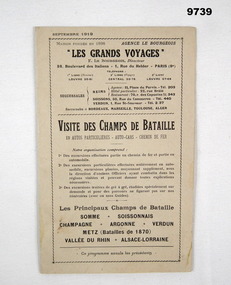
Pamphlet - FRENCH TOURISM, 1919, C.1919
Item in the collection relating to C.J.C. McQuie MM, refer Cat No 9680P for his service details.Pamphlet 16 pages, light brownish colour, all print in black, language is French, pages cover places to visit, advertising, maps and drawings, one metal staple holds all together."Les Grands Voyages"french, mcquie, pamphlet