Showing 613 items
matching location map
-
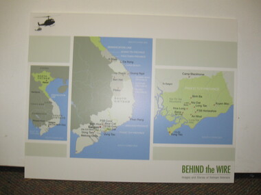 National Vietnam Veterans Museum (NVVM)
Poster - Poster, Information Board, Behind The Wire
Storybord with three maps of Vietnam showing various locations of importance such as Saigon, Nui Dat, Vung Tau, Binh Ba, Long Tan, FSB Horseshoe, An Nhut, Baria, Hoa Long and Xuyen Moc.storyboard, behind the wire, maps, saigon, nui dat, vung tau, long tan -
 Clunes Museum
Map, 1890
Features location of Club Hotel, Union Bank, Engine rooms, Port Phillip Hotel, Pyrites furnace, Battery, Office, Smith Shop,Surface Tramway to BatteryPhotocopy of map/plan of Dixon's New North Clunes, Central Clunes Co. and South Clunes utd showing various shafts and pre-emptive rights. Scale 1 inch = 100 feetOn front in red ink; "drawn in 1890"mine shafts, hotels, plans -
Clunes Museum
Map, Surface Geology Plan
Plans show various shaft locations.1 Photocopy of Plan Block 23/19 Scale 1 inch = 100 feet .2 Photocopy of Plan Block 19/19 Scale 1 inch = 100 feet .3 AERIAL PHOTOGRAPH WITH WORKINGS MARKED - LAMINATED.1 C-21 North Broken Hill Ltd Clunes Block 23/19 .2SOUTH CLUNES MINE Ltd Clunes Block 19/19north broken hill ltd, surface geology plan -
Clunes Museum
Map, PRODUCED BY CHARLES FENTON, TRADERS OF FRASER STREET CLUNES
4 X SHETS OF PAPER COMMECTED WITH STICKY TAPE SHOWING SHOPS OF FRASER STREET CLUNES WITH THE NAMES OF TRADERS AT EACH SHOP LOCATION. ALTHOUGH UNDATED IT IS EXPECTED THAT THIS MAP DATES TO APPROX 1870C1870fraser street, traders of clunes -
Clunes Museum
Document - NEWSPAPER CUTTING AND HISTORICAL GUIDE, WHAT TO LOOK FOR IN AND WHERE TO FIND IT, 1971/1972
HISTORY LOCATIONS CLUNES SITES.1 NEWSPAPER CUTTING CLUED ONTO PAPER - HISTORY OF CLUNES .2 3 X PAGES AND MAP DETAILING PLACES OF INTEREST IN CLUNESlocal history, places of interest clunes -
Clunes Museum
Photograph, EXTENT OF MINE WORKINGS AT CLUNES, 1987
MINE WORKINGS IN CLUNESAERIAL PHOTOGRAPH CLUNES GOLD WORKINGS MAP SUPERIMPOSED. MOUNTED ON CARDBOARD WITH DETAILS OF MINE LOCATION. TYPED DESCRIPTION PASTED BELOW.port phillip mine, aerial photograph, quartz mining -
Tatura Irrigation & Wartime Camps Museum
Document, Geological Plan, Eildon Dam Site, 1945
To record details of geological aspects of EildonA series of maps illustrating rock formations etc., locations, boundaries and planswater/irrigation, documents, maps -
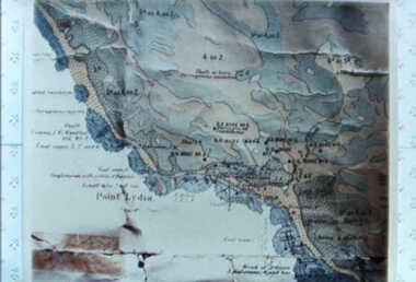 Inverloch Historical Society
000587 - Map - Point Lydia - Harmers Haven - Location of coal test bore holes - from Iris Earnshaw
-
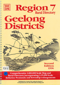 Victorian Aboriginal Corporation for Languages
Map, Country Fire Authority, Region 7 rural directory Geelong districts, 1996
Shows roads, railway, power lines, buildings and emergency locations. Lists property owners.mapsgeelong, regional victoria, fire protection -
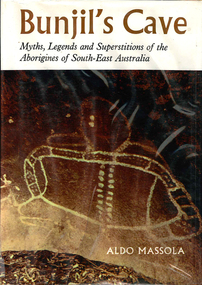 Victorian Aboriginal Corporation for Languages
Book, Aldo Massola, Bunjil's cave : legends and superstitions of the Aborigines of South-East Australia, 1968
Stories from the Aboriginal people of South-East Australia. Includes Creation Stories, Myths and legends. Written in two sections, The myths and The Land Beyond the Sky. Includes location lists.Maps, b&w photographs, illustrationswotjobaluk, mara, kulin, kurnai, murray river, myths, legends, creation stories -
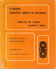 Victorian Aboriginal Corporation for Languages
Book, W J Oates, A revised linguistic survey of Australia, 1970
Lists languages under areas and language classification; records location, previous research, degree of urgency of research and assessment of total linguistic knowledge; index of variant language names.Mapslinguistics -
Victorian Aboriginal Corporation for Languages
Book, C C Culvenor, The boundaries of the Mount Franklin Aboriginal Reserve, 1992
"This enquiry into the boundaries of the Mount Franklin Aboriginal Reserve had its origins in the preparation of a biography of geologist Thomas Smith of Sandon, which raised queries about Boundary Gully Road, Parkers Gully and the location in that vicinity of the Reserve boundary. At a subsequent meeting of the Daylesford Historical Society, commemorating the 150th anniversary of the founding of the Aboriginal Reserve at Franklinford in 1841, it became clear that the actual boundaries were only poorly known ... A search for information srouces in Melbourne and Sydney did not produce an overall Plan, but it is hoped that the material obtained will present a sufficiently accurate picture to be useful to other local historians and be of some interest also to the general reader" --Preface. Contents: The boundaries of the Mt. Franklin Aboriginal Reserve The five mile radius The Tarrengower challenge Provisional boundaries Survey of the Reserve Breakup of the Reserve References Appendices.maps, b&w illustrations, b&w photographsmount franklin -
 Victorian Aboriginal Corporation for Languages
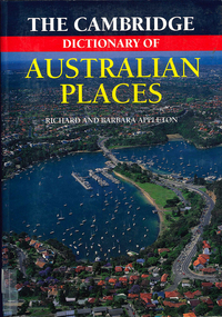
Book, The Cambridge dictionary of Australian Places, 1992
Lists thousands of place names across Australia, giving a detailed account of the name and location, shire etc.maps, pronunciation guidesgazetteer, nomenclature, maps, geography, pronunciation -
Victorian Aboriginal Corporation for Languages
Book, Leon Costermans, Native trees and shrubs of South-eastern Australia, 1998
Coloured photos and detailed line drawings are used to give a very clear description of the specific plants and details of their locations and environments.Colour photographs, illustrations, mapsplants, botany, nsw, victoria, south australia -
Clunes Museum
Photograph - PHOTOGRAPHS AND DOCUMENTS
... of James Goldsworthy Scholl 4. Copy of parish map showing school... of parish map showing school location 5. Written account of family ...James Goldsworthy Scholl had a private school in Clunes in early 1870's. He was born in Cornwall, U.K. in 1836 and married Emily Bennett in February 1857. James arrived in Melbourne on the "Agincourt" in November 1863 and Emily in July 1863 on the "Golden Land" James died in 1893 and Emily 19321. Enlarged photo of Mrs. James Goldsworthy Sholl (nee Bennett) Approx 1879 with 5 of 11 children (from left to right Albert 1875, Laura 1864, Emily Scholl, Bertha 1877, Arthur 1870, Anne 1868) 2. Original photo of Emily Scholl 3. Original photo of James Goldsworthy Scholl 4. Copy of parish map showing school location 5. Written account of family historyOn item 2. and 3. Printed gold lettering Yeoman, Paris Panel, Royal Arcade Melbournescholl, goldsworthy, private school, education -
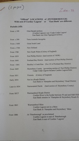 Peterborough History Group
Document - Names of town and locations
copy of gazetting of the town, history of names within the district, history of the street names in PeterboroughPhotocopied pages, map, typed documents -
 Peterborough History Group
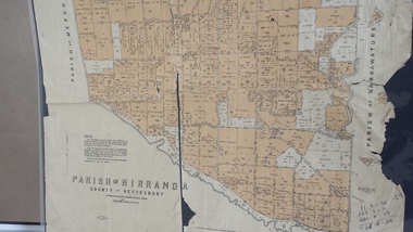
Map - Map of the Parish of Nirranda, Parish of Nirranda
Map of the Parish including roads, names of landowners, location of schools etc in 1939A3 size map of the Parish of Nirranda in 1939nirranda, maps, parish map -
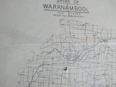 Peterborough History Group
Map - Shire of Warrnambool East Riding
Contextual location of Peterborough town within the shire at that time, including local roads.Historic informationA3 size map of the Warrnambool Shire East Riding, includes landscape details, and the location of town in the Shire.Irvine written in pencil on the backpeterborough, curdies river inlet, old maps, warrnambool shire map -
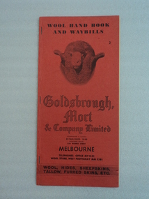 National Wool Museum
Booklet, 1946
Red paper booklet with three metal staples on spine on left side. Front cover has black text at top reading -WOOL HAND BOOK / AND WAYBILLS-. Below is an image of a rams head. Below, in decorative font is text that reads -Goldsbrough, / Mort / & Company Limited-. Contact details and services provided are also listed on the front cover. Back cover has an image and addresses of warehouse storage locations. Inside are four white pages of instructions on how to use the booklet, as well as tips on the inside of the front and back covers. There are several yellow lined pages upon which the owner can record the wool bale details with carbon paper. Several pages have been used/removed from this booklet. There is a foldout map inside the back cover.wool growing, wool production, wool auctions, wool bales, wool sales, mrs robyn adams, wool transport, goldsbrough, mort and company limited, elder smith goldsbrough mort limited, dalgety and company limited elder smith goldsbrough mort limited -
 Stawell Historical Society Inc
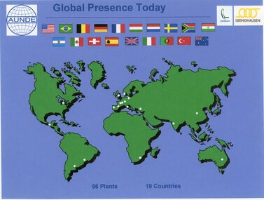
Photograph - Aunde Album 29, Global Presence Today, 2002
Aunde / Norwellan Textiles North Western Woolen Mills became Norwellan Textiles then AUNDEColour landscape photo: World map with flags, white dots showing locations of 56 plants in 19 coutries.Global Presence 56 plants in 19 Countries. Esteban logo, Isinghausen logo, Aunde logo with flagsindustry, aunde -
Stawell Historical Society Inc
Map, Gold Mines of Australia, Stawell Investment Geological Plan. Mine Area showing Mineshafts
The Reefs Mine shaft locationsGold Mines of Australia Ltd mining, gold, map -
Stawell Historical Society Inc
Map, Gold Mines of Australia, Plan of Stawell Goldfield. Mining Leases, 1952
And Shaft Locations 1952 G G Birch Mining Surveyormining, gold, map -
Koorie Heritage Trust
Book, Blake, Barry J, Australian Aboriginal Languages : a general introduction, 1991
Non-technical introduction covering phonology, grammar, vocabulary, sociolinguistics, language relationships pidgin and Aboriginal English, loan words in English, wordlists in Tiwi, Malak-Malak, Alyawarre, Walmajarri, Nyungar, Pitjantjatjara, Wemba-Wemba, Dharawal, Bidyara, Pitta-Pitta, Kalkatungu and Mayi-Yabi. In 1788 Australia had more than 200 such languages -- as different from each other as English is from French. Today, more than 100 are extinct and many of the rest are under threat. Professor Blake describes the sounds, spelling and location of the different languages, and dispels many popular myths.viii, 138 p. : ill., map. ; 21 cm.Non-technical introduction covering phonology, grammar, vocabulary, sociolinguistics, language relationships pidgin and Aboriginal English, loan words in English, wordlists in Tiwi, Malak-Malak, Alyawarre, Walmajarri, Nyungar, Pitjantjatjara, Wemba-Wemba, Dharawal, Bidyara, Pitta-Pitta, Kalkatungu and Mayi-Yabi. In 1788 Australia had more than 200 such languages -- as different from each other as English is from French. Today, more than 100 are extinct and many of the rest are under threat. Professor Blake describes the sounds, spelling and location of the different languages, and dispels many popular myths.australian languages. | aboriginal australians -- languages. | language - linguistics - phonology and phonetics | language - kriol | language - sociolinguistics - secret and special languages | language - vocabulary - human classification | language - vocabulary - word lists -
Whitehorse Historical Society Inc.
Map, Dandenong Ranges Area, 1956
Sheet 1. Parts of Parishes: Nunawading, Warrandyte and Ringwood. Scale: 10 chains : 1 inch. Contour intervals marked and locations of buildings.Sheet 1. Parts of Parishes: Nunawading, Warrandyte and Ringwood. Scale: 10 chains : 1 inch. Contour intervals marked and locations of buildings. Compiled from aerial photographs and cadastral survey information.Sheet 1. Parts of Parishes: Nunawading, Warrandyte and Ringwood. Scale: 10 chains : 1 inch. Contour intervals marked and locations of buildings. maps, ringwood, mitcham, warrandyte -
Whitehorse Historical Society Inc.
Map, Map of Mitcham, Tunstall and Blackburn, c1937
Map of Mitcham, Tunststall and Blackburn showing the location of T.M. McDonnell, real estate agent, Whitehorse Road, MitchamMap of Mitcham, Tunststall and Blackburn showing the location of T.M. McDonnell, real estate agent, Whitehorse Road, MitchamMap of Mitcham, Tunststall and Blackburn showing the location of T.M. McDonnell, real estate agent, Whitehorse Road, Mitchammaps, mcdonnell, t.m. -
Whitehorse Historical Society Inc.
Map, Map of Mont Albert, Box Hill, Surrey Hills and Blackburn, c 1933
Map of Box Hill and Surrounds, showing location of Box Hill Grammar School.Map of Box Hill and Surrounds, showing location of Box Hill Grammar School.Map of Box Hill and Surrounds, showing location of Box Hill Grammar School.maps, box hill grammar school -
Whitehorse Historical Society Inc.
Map, City of Nunawading, c1975
Map of City of Nunawading, showing location of 186 parks and reserves.Map of City of Nunawading, showing location of 186 parks and reserves. Scale 1:10,000 with list of streets and their map coordinates.Map of City of Nunawading, showing location of 186 parks and reserves. city of nunawading, parks and reserves -
Whitehorse Historical Society Inc.
Map, City of Nunawading, c1980
... schools Map of the City of Nunawading with list and location of 47 ...Map of the City of Nunawading with list and location of 47 schools.Map of the City of Nunawading with list and location of 47 schools. Scale 1 mile = 3.75 inMap of the City of Nunawading with list and location of 47 schools. city of nunawading, maps, schools -
Whitehorse Historical Society Inc.
Map, Facilities provided for you, 1970
Map of the City of Nunawading showing main roads and reserves with numbers indicating location of Halls, Infant Welfare Centres, Elderly Citizens Clubrooms and other major Council facilities. Route of proposes Healesville Freeway marked.Map of the City of Nunawading showing main roads and reserves with numbers indicating location of Halls, Infant Welfare Centres, Elderly Citizens Clubrooms and other major Council facilities. Route of proposes Healesville Freeway marked.Map of the City of Nunawading showing main roads and reserves with numbers indicating location of Halls, Infant Welfare Centres, Elderly Citizens Clubrooms and other major Council facilities. Route of proposes Healesville Freeway marked.city of nunawading, maps, maternal and child health centres, senior citizens centres, healesville freeway, parks and reserves -
Whitehorse Historical Society Inc.
Map, Tunstall 1945, 1945
A map drawn from memory about 20 years ago by Colin Fraser of the businesses and residents of Tunstall, 1945, including the location of Fraser General Store.A map drawn from memory about 20 years ago by Colin Fraser of the businesses and residents of Tunstall, 1945, including the location of Fraser General Store.A map drawn from memory about 20 years ago by Colin Fraser of the businesses and residents of Tunstall, 1945, including the location of Fraser General Store.tunstall, tunstall railway station, tunstall avenue nunawading, tunstall state school no 4190, fraser, colin