Showing 126342 items
matching main-road
-
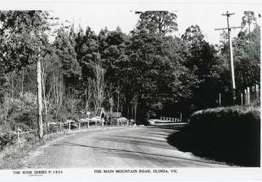 Mt Dandenong & District Historical Society Inc.
Photograph, The Main Mountain Road, Olinda, c1950s
Copy of Rose Series Postcard number 1834Copy of Rose Series Postcard # 1834 showing the Main Road, Olinda looking towards Sassafras. The Lich gate and 'Hathaway" on LHS. c1950s.olinda, lich gate, hathaway -
 Melbourne Tram Museum
Pamphlet, Major Road Projects Authority, "There's big changes on Punt Road from 30 January 2019", Jan. 2019
Pamphlet describing roadworks at Punt Road and Swan St intersection during January and February 2019. Photo of intersection has a B class at the Punt Road tram stop travelling west towards the city.trams, tramways, road works, punt rd, swan st -
 Eltham District Historical Society Inc
Slide - Photograph, Possibly the Ersilac Parade travelling along Main Road, Eltham, c.1958
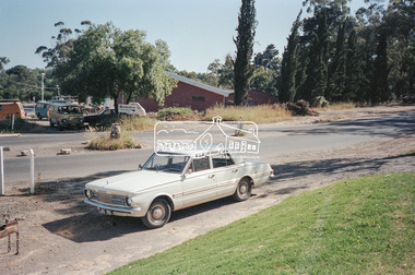
View from Grace Mitchell's shop at the corner of Mount Pleasant Road and Main Road. Grace Mitchell was probably best known for her Eltham shop at the corner of Mt Pleasant Road and Main Road. Grace's memories covered many local identities who were patrons of her shop between 1954 and 1971. From the elevated position of her shop and home Grace was able to view a varied passing parade of Eltham events from ERSILAC, Easter and Eltham Festival parades passing on their way to Eltham Lower Park, circuses in Wingrove Park (then Bremner’s Reserve), roadworks and other happenings. Bremner's Reserve was renamed Wingrove Park c.1970 This photo was from a series of images presented by Grace Mitchell at a Society talk 10 March 1993 on the theme of “My Eltham”. Alistair Knox had one of the first VW Beetles in Eltham; perhaps the one shown is his. This model has a large rear window, first introduced in 1958. The Holden ute could be an FC or FE. The FE was produced July 1956-April 1958 and the FC May 1958-January 196035mm Kodak 5052 TMX Black and White transparency, 1 strip, 6 frames Black and white print 17 x 25.4 cmcars, bremner's flat, eltham, ersilac parade, main road, mount pleasant road, wingrove park, festival, horse drawn carriage -
 Mt Dandenong & District Historical Society Inc.
Photograph, 1908 View of Kalorama Gap From the Main Road, 1908
View of the Kalorama Gap from main Road (now Ridge Road), looking across Walker's raspberry patch with Mountjoy coaching stables on the LHS and Mountjoy Guest House in centre. Price's house and shop on the RHS.mountjoy, walker, raspberry, coach, stables -
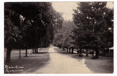 Marysville & District Historical Society
Postcard (item) - Black and white postcard, Main Road Marysville, Unknown
Postcard of early black and white photograph of the main street of Marysville in Victoria. This street is now known as Murchison Street.Postcard of early black and white photograph of the main street of Marysville in Victoria. This street is now known as Murchison Street.POST CARD PLACE/ POSTAGE/ STAMP/ HEREmarysville, victoria, murchison street, postcard, souvenir -
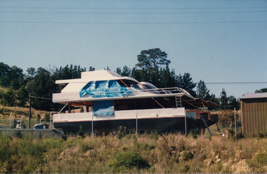 Eltham District Historical Society Inc
Photograph, Peter Bassett-Smith, Research Industrial Centre, Main Road, April 1988, 1988
Two colour photographs showing two views of Research Industrial Centre, Main Road, April 1988 including site with boats under construction.main road, research vic., industrial estate, boats -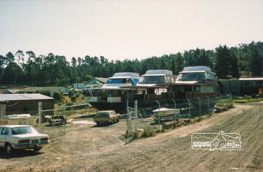
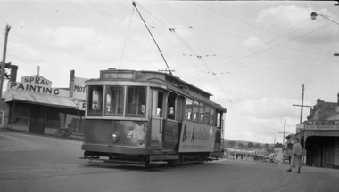 Ballarat Tramway Museum
Negative, Wal Jack, No. 21 outbound in Main Road Ballarat East, 15-9-1953
Print notes the "Made in Australia" side posters on the side of tram 21. Taken opposite Ballarat East Post Office, Main St 15-9-1953.Yields information about celebrations the intersection of Main Road and Humffray St and Ballarat 21.Negative and Digital image of the Wal Jack Ballarat Negative file of No. 21 outbound in Main Road Ballarat East at the intersection with Humffray St. Tram has a large "Buy Australia" panel on the side and destination of Mt Pleasant. - See Reg Item 5333 for another photo of the tram. in the background is a motor body workshop and Robson's Glass shop. Print also held - see item 8992trams, tramways, humffray st, main road, mt pleasant, decorated trams, buy australian, tram 21 -
 Ballarat Heritage Services
Photograph - Photograph - Colour, Clare Gervasoni, Former Yandoit Hills School 2052 after being moved to Hepburn Springs, c2005, c2005
This building was moved from Yandoit Creek to the corner of Main Road and Seventh Street, Hepburn Springs. Colour photograph of on old schoolhouse that was moved from Yandoit Hills to the corner of Main Road and Seventh Street, Hepburn Springs. The building was used for religious services before being turned into a private residence. yandoit hills state school no 2052, education, hepburn springs, yandoit hills, yandoit creek -
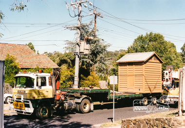 Eltham District Historical Society Inc
Photograph, Lock-up No. 17 arriving at the Local History Centre, 728 Main Road, Eltham, March 2001, March 2001
The portable lockup at Eltham is not original to the site. The date of construction is unknown, believed from the 1880s. It is a prefabricated design and each of the timber panels are individually numbered on the inside surfaces. It is amongst a large group of portable lockups, categorised as 'Portable Lock Up - Timber - Later' and also known as the "Casterton style", based on the only known plan for portable lock ups, built for the Casterton Police Station, in 1907. The later portables have been in use since the 1880s. It is not known how many lock ups of this type have been constructed in Victoria. At least 50 examples have been documented around the state. Of these, 42 are known to be extant. The original 1860s site lockup was a 2-cell bluestone construction. Some of the original bluestone remains. It was used in the 1970s as traffic island edging at the intersection of Main Road and Wattletree Road where it was painted white then later relocated back to this site in the 1980s to be used as edging for a driveway access off Main Road beside the former Police Residence where the Police Station originally stood. Evidence of some of this edging remains in place today leading to the replica Police Station. Other blocks were used to define the garden edging in the carpark at the rear of the residence.This lockup used to be located at the Police Station in Pryor Street and was then stored in Youth Road before being acquired for the Local History Centre 3 colour photographseltham, main road, police residence, local history centre, eltham district historical society, courthouse, youth road -
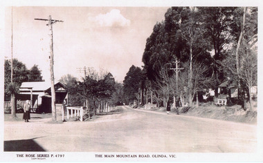 Mt Dandenong & District Historical Society Inc.
Photograph, The Main Mountain Road, Olinda, c1940
Copy of Rose Series Postcard #4797Copy of Rose Series Postcard #4797. View down Main Road Olinda towards Sassafras c1940s showing Post Office to the left.Three people visible in picture.rose series, post office, postcard, olinda, main road -
 Stawell Historical Society Inc
Photograph, Upper Main Street Stawell looking East with on left the 2 story Allingham building & behind the cart is the Commercial Hotel c1910
Upper Main Street Stawell. Looking East c1910. On left two story Allingham building behind cart is Commercial Hotel. Oriental Bank. Punchard Furniture. Crown Cross Poppet head visible on Big Hill. The side of the Mechanics Institute visible near centre. H S Dawson Chemist. Clarke & Scott Drapery on right. Same as 6730-1 & 1423Streetscape of upper main street looking east, Crown Cross poppet head at end of street in middle of streetUpper Main Street Stawell.mining, streetscape, businesses -
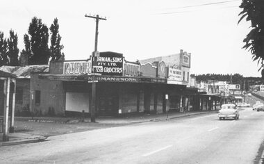 Ringwood and District Historical Society
Photograph, Maroondah Highway Central, Ringwood. Corner Main Street & Adelaide St. looking east towards Warrandyte Road- 1966
History of the Norman Cash Grocery Stores. Normans started grocery store in Drummond Street Oakleigh in 1903 and expanded to 13 stores in adjacent suburbs, Ringwood being one of these. Photo is Norman & Sons P/L corner of Maroondah Highway and Adelaide Street.Black and white photograph (2 copies) Typed below one copy: "Corner Main Street & Adelaide St. looking east towards Warrandyte Road - 1966". Image shows Norman & Sons Grocer store on corner of Adelaide Street and Main Street. -
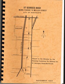 Melbourne Tram Museum
Document - Report, Road Construction Authority - RCA, "Report to the Minister by the Steering Committee on Options for St Georges Road, Northcote", Nov. 1984
Set of two comb bound, brown covers with a plan of the location on the cover, with a report for the reconstruction of St Georges Road, Merri Parade to Miller St, November 1984. First volume is titled "Report to the Minister by the Steering Committee on Options for St Georges Road, Northcote", looks at four different options with sub options. Has drawings for the various options. Second volume - "Steering Committee Recommendations" Prepared by the Road Construction Authority - RCA - Metropolitan Division. See Reg item 621 for the actual drawings.trams, tramways, st georges rd, thornbury, northcote, tramways, road works, construction -
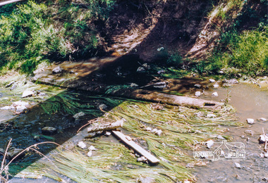 Eltham District Historical Society Inc
Photograph, Cross beam from old timber Main Road bridge over the Diamond Creek, 1992, 1992
Two colour photographs of old cross beam from original Main Road trestle bridge lying in creek bed. It is downstream from the current re-structured bridgebridges, diamond creek, main road, eltham south -
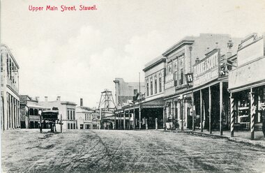
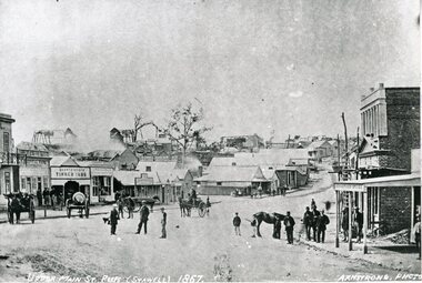 Stawell Historical Society Inc
Photograph, Upper Main Street looking East from Patrick Street corner across Layzell Street 1866
Upper Main Street looking East. Poppet Heads in Background. Oriental Bank second on left then Quartz Reef Timber Yards. Intersection is Layzell St Main Street. Advertiser Office on right in front of Earlier Mechanics Institute. Part of a collection of Photographs by Mr. O.G. Armstrong as commissioned by the Shire of Stawell for the Inter-colonial and Paris Exhibition in Melbourne in 1866.Upper Main street with Poppet Heads in the background, the Oriental Bank second on left & then Quartz Reef Timber Yard 1867 Advertiser Office on right and earlier Mechanics Institute.Upper Main Street Reefs 1867stawell mining streetscape -
 Eltham District Historical Society Inc
Photograph, Ruth H. Pendavingh, Reconstruction of Main Road from Main Road Bridge to Mount Pleasant Road, Eltham, 1984
The original timber bridge over the Diamond Creek was built around 1840. It was destroyed by floodwaters in October 1923. A temporary bridge was rigged up but further damaged in April 1924. A new concrete bridge was built and opened in October 1926. The bridge decking was widened along with Main Road to Dalton Street by the Road Construction Authority in 1984. The upgraded bridge was re-opened October 25, 1984, 78 years after its original opening. (EDHS Chronology of known local events 1835- early 2000)Three colour photograph prints 1984, bridge construction, diamond creek (creek), eltham south, main road, main road bridge, road construction -
 Eltham District Historical Society Inc
Photograph, Main Road, Research
Three colour photographs showing Main Road, Research in the vicinity of Research Industrial Estate. 1. Looking north towards the Aqueduct 2. Looking north towards former road alignment 3. Looking north towards the Little Eltham Theatre 3.main road, research, research industrial estate -
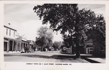 Bacchus Marsh & District Historical Society
Postcard, Main Street, Bacchus Marsh, circa 1950
The Main Street of Bacchus Marsh underwent significant change from the early 1960s. Many older buildings began to be demolished after the early 1960s and into the 1980s. This view shows a central section of Main Street before this transformation took place. Produced as part of a series by the Murray Views Postcards and Souvenirs Company.Black and White postcard image of Main Street, Bacchus Marsh dated around 1950. View is looking towards the West.Murray Views No.7, Main Street, Bacchus Marsh, Vic.roads and streets bacchus marsh vic., main street bacchus marsh vic. -
 Eltham District Historical Society Inc
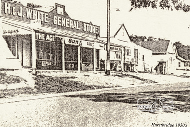
Greeting Card, Main Road, Hurstbridge, 1950s, 1950s
Greeting card with stylised sepia image of Main Road, Hurstbridge in the 1950s featuring Whites General Store and Feed Store next to the Post Office and the then new Police Station beyond.Hurstbridge & District Local History Group, Seasons Greetingsmain road, hurstbridge, whites general store, post office -
 Eltham District Historical Society Inc
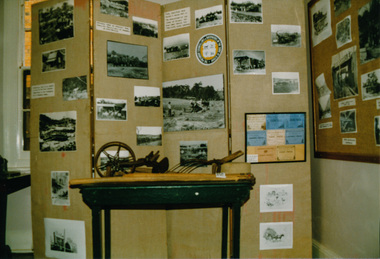
Photograph, Heritage Display, Heritage Week at 728 Main Road, Eltham, 1990, 1990
Two colour photographs of the Heritage Photographic Displays during Heritage Week in the former Police Residence and current home of Eltham District Historical Society at 728 Main Road, Eltham. One display was titled: Public Works- Construction of roads, bridges, railways etc.heritage week, eltham, courthouse, heritage display, exhibition, photographs, activities -
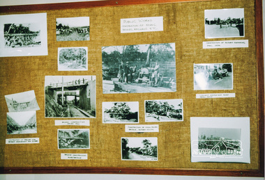 Eltham District Historical Society Inc
Photograph, Heritage Display, Heritage Week at 728 Main Road, Eltham, 1990, 1990
Two colour photographs of the Heritage Photographic Displays during Heritage Week in the former Police Residence and current home of Eltham District Historical Society at 728 Main Road, Eltham. One display was titled: Public Works- Construction of roads, bridges, railways etc.heritage week, eltham, courthouse, heritage display, exhibition, photographs, activities -
 Glen Eira Historical Society
Album - Album page, Kambrook Road, Circa 1972
This page of photographs is part of the Caulfield Historical Album 1972. This album was created in approximately 1972 as part of a project by the Caulfield Historical Society to assist in identifying buildings worthy of preservation. The album is related to a Survey the Caulfield Historical Society developed in collaboration with the National Trust of Australia (Victoria) and Caulfield City Council to identify historic buildings within the City of Caulfield that warranted the protection of a National Trust Classification. Principal photographer thought to be Trevor Hart, member of Caulfield Historical Society. Most photographs were taken between 1966-1972 with a small number of photographs being older and from unknown sources. All photographs are black and white except where stated, with 386 photographs over 198 pages. First 2 images: milkbar and residence corner Kambrook and Balaclava Roads ie south west corner - building named Airdrie 3rd image: https://vhd.heritagecouncil.vic.gov.au/places/43737 - re 26 Kambrook Road and 345 Balaclava Road corner building ie south east corner: A prominently situated two-storeyed complex of late Victorian buildings consisting of "Wybar's Buildings" occupying the Balaclava Road/ Kambrook Road corner and the "Caulfield Bakery" facing Kambrook Road, separated by a driveway from a single storeyed shop. The main building has a comer splay and balustraded parapet with curved pediments, the words "Wybar's Buildings 1887" having been obliterated but "Caulfield Bakery 1887" with the characteristic wheatsheaf surviving in raised cement work. The walls are stuccoed and richly ornamented with bracketed cornices and keystones with masks extending to the Bakery. The main building is further distinguished by the Masonic symbol of the mason's dividers in the pediment whilst the upper level of the bakery is in overpainted brickwork. The single storeyed shop incorporates the bracketed cornice and consoles characteristic of the main buildings and is in other respects a utilitarian structure. 4th image: https://vhd.heritagecouncil.vic.gov.au/places/42415 (on 24/01/2021) - 196 Kambrook Road An imposing late Victorian poly-chrome brick asymmetrical villa with corner verandah and projecting west facing wing with faceted window bay to the facade. Body bricks are red and relieved by cream and black brick banding and by cream bricks to the bracketed eaves. The fretted barge with king post treatment and timber posted verandah are unique in the Municipality and unusual in the metropolitan area and demonstrate an understated appreciation of the emerging Queen Anne mode.345 Balaclava and 26 Kambrook Roads HO91 - City of Glen Eira https://vhd.heritagecouncil.vic.gov.au/places/43737 (on 24/01/2021) "Wybar's Buildings" at the corner of Balaclava Road and Kambrook Road are important as a prominent late Victorian commercial development incorporating a variety of activities including a bakery and possibly a coffee palace, the latter understood to be unique within the municipality, but characteristic of the period. It is a rare complex of its type in Caulfield and is important also as evocative evidence of the late Victorian Land Boom and the creation of a small now defunct commercial centre at this location by the George Wybrow. 196 Kambrook Road HO122 - City of Glen Eira https://vhd.heritagecouncil.vic.gov.au/places/42415 "Glencoe" is situated at no. 196 Kambrook Road, Caulfield North and was built for the boot manufacturer, Robert Bruce Mair, in 1888. It is of historic and aesthetic significance. It is historically significant (Criterion A) as the home of an inner suburban industrialist, notable a boot manufacturer, demonstrating the attraction of Caulfield as a residential location for the manufacturers of the metropolis during the late Victorian Boom period. It is aesthetically significant (Criterion E) as a very early example of a Queen Anne influenced late Victorian villa, comparing at the State level with ''Woodlands'' (1888), North Essendon, generally acknowledged to be one of Australia's earliest houses to fully exploit this emerging style. The ornamental timberwork is especially expressive of the new architectural fashion and compares with the house at 33 Clarence Street, Elsternwick (1888-89).Page 105 of Photograph Album with two photographs of a milk bar and attached residence, one older photograph of Wybar's Building and another photograph of a house on Kambrook Road (all are landscape).Handwritten: 196 KAMBROOK ROAD / 1970 - GAFFNEY MRS S.M. [under bottom right photo] / 100 [bottom left]trevor hart, kambrook road, victorian style, caulfield north, parapets, wybar's buildings 1887, caulfield bakery 1887, architectural features, painted bricks, balaclava road, george wybrow, shops, milk bars, airdrie, polychrome bricks, verandahs, queen anne architectural style, houses, glencoe, robert mair -
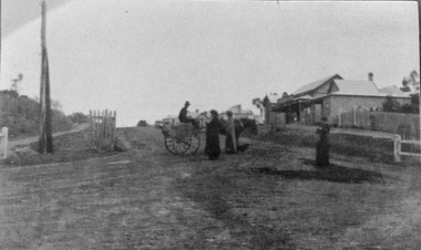 Phillip Island and District Historical Society Inc.
Photograph, Main Street, Cowes
Building on the right is Robb Brothers StoreCopy of a sepia photo of Main Street,[Thompson Ave] Cowes, showing dirt road with buildings on the right side.Looking south uphill along Thompson Ave. A man on a jinker on road talking to 2 women and another woman standing on right side of road.Main Street [Thompson Ave] Cowes. Robb Bros Storecowes, thompson avenue cowes, photographs, transport - jinker, robb brothers -
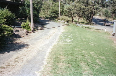
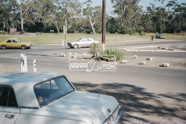
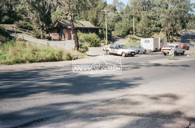 Eltham District Historical Society Inc
Negative - Photograph, Intersection of Mt Pleasant Road at Main Road, Eltham, c.Dec. 1983
Reconstruction work was planned for Main Road to install a roundabout at Mount Pleasant Road. Traffic to Lower Plenty and Templestowe to be diverted down Bridge Street (and Bolton Street) effective January 1984. The proposed roundabout did not proceed. Instead traffic islands on Mount Pleasant Road were installed in place of temporary blocked out islands and revised extended driveway to properties 622-642 Main Road with access off Mount Pleasant Road instead.Film - Kodak CM 400 5079 7 strips, 26 framesinfrastructure, roads, road construction, roundabout, road sign, main road, mount pleasant road, eltham -
 Eltham District Historical Society Inc
Negative - Photograph, Intersection of Mt Pleasant Road at Main Road, Eltham, c.Dec. 1983
Reconstruction work was planned for Main Road to install a roundabout at Mount Pleasant Road. Traffic to Lower Plenty and Templestowe to be diverted down Bridge Street (and Bolton Street) effective January 1984. The proposed roundabout did not proceed. Instead traffic islands on Mount Pleasant Road were installed in place of temporary blocked out islands and revised extended driveway to properties 622-642 Main Road with access off Mount Pleasant Road instead.Film - Kodak CM 400 5079 7 strips, 26 framesinfrastructure, roads, road construction, roundabout, road sign, main road, mount pleasant road, eltham