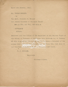
Showing 428 items
matching north greensborough
-
 Eltham District Historical Society Inc
Photograph - Digital Photograph, Alan King, Graves of Thomas Sweeney and family, Eltham Cemetery, Victoria, 27 January 2008
The grave of Thomas Sweeney, former convict turned respectable citizen. The Murray and Sweeney families were both early settlers of the Eltham district and connected by marriage. Their family plots are located side by side in the Catholic section of the Eltham Cemetery. Irish-born Thomas Sweeney is regarded as the first settler in Eltham. He was transported to Sydney in 1823 after being convicted of arson. He was granted his freedom in 1838 and married Margaret Meehan in the same year. They moved to Melbourne and in 1842 Thomas purchased 110 acres beside the Yarra River in the vicinity of present-day Sweeneys Lane. He called the property ‘Culla Hill’ and built a small slab hut (reputedly with Wurundjeri help; Margaret is said to have run an informal hospital for them in return). This was followed in 1846 by more substantial buildings consisting of a three-roomed Irish-style ‘longhouse’ and a barn made of stone and handmade bricks, with doors large enough to accommodate a fully loaded wagon. When the gold rush came, Thomas prospered by selling meat and potatoes to the prospectors, enabling him to purchase a further 308 acres in 1856. He promoted the construction of a bridge over the Plenty River and the establishment of a school at Eltham. Roman Catholic Church services were held at Culla Hill in the early years. When he died in 1867, he was regarded as a respected member of the community. Thomas and Margaret are buried in Eltham Cemetery with many of their descendants. Their first son John continued to farm Culla Hill until his death in 1909. Culla Hill passed out of the Sweeneys' possession in 1939. The house and barn remain today, though lesser outbuildings have gone. The facade of the house is much the same as it was in the 1840s. Sacred To the memory of Thomas Sweeney Who died Sep 6th 1867 Aged 65 years May his soul res in peace Also his wife Margaret Died Oct 3rd 1884 aged 73 years And their daughters Annie Died Aug 22nd 1860 aged 21 years Johanna Died Aug 19th 1872 aged 22 years Margaret Died 7th Sep 1913 aged 72 years R.I.P. Also In Memory Of John Sweeney Died 24th May 1909 Aged 65 years Also of his wife Ellen Died 8th March 1910 Aged 64 years R.I.P Also In Memory Of Caroline Infant daughter of John & Ellen Sweeney Published: Nillumbik Now and Then / Marguerite Marshall 2008; photographs Alan King with Marguerite Marshall.; p55 From the piety and poverty of 19th century Eltham, 20th century artists and environmentalists, to today’s comfortable middle class, Eltham Cemetery records it all — and more. A visit to Eltham Cemetery reveals an important social record since its beginnings in 1858. The cemetery was situated on about six acres (2.4ha) (now around 4.8ha) at the corner of Mount Pleasant and Metery Roads.1* It is thought that Metery Road was originally called Cemetery Road, but in the early 1940s, a resident, possibly a councillor, objected to the name resulting in the change.2 Much can be gleaned about the developing Eltham community from burial styles and the names of former local residents. Originally the cemetery was divided into Christian denominations, like others of that time, following the United Kingdom burial system. In 1861 the cemetery included Church of England, Presbyterian, Roman Catholic and Wesleyans (later Methodist) sites. Graves also indicated social class. Some had grand tombstones, perhaps fenced with ornamental cast iron railing, but most in the 1860s and 1870s were constructed of modest stone slabs.3 This indicated the poverty of the district, which was largely inhabited by farmers on small landholdings. A poignant reminder of the high rates of infant mortality of those times, are the many infants and young children recorded on the headstones. Major changes occurred in the cemetery in the late 20th century as Christian adherence weakened and society became more egalitarian and informal. In the early 1970s a non-denominational lawn section for burials was established. Since then all new areas have been non-denominational to accommodate the more diverse local community. Now, instead of large ornamental headstones, some mourners have chosen boulders, reflecting the natural Eltham style, while others choose graves in the lawn areas or niches in walls. In the late 1970s, the University Donor Section was established north-west of Candlebark Lawn for those who donated their bodies for The University of Melbourne medical research. In the early 1980s the natural Australian garden style, popular in Eltham, was mirrored in a new section called Ashes Walk. Local landscape architect Gordon Ford, who had popularised this style, designed the Walk using boulders shaded by native plants beside curved pathways. Landscape architect Robert Boyle later redesigned Ashes Walk and developed other parts of the cemetery in keeping with this style.4 Appropriately Ford, who died in 1999, was interred in the Native Garden Section in a cluster of sites shaded by a large eucalyptus tree.5 By 2007, about 6400 interments were recorded in the Eltham Cemetery. Close inspection reveals notable names in the district’s history. The grave of Thomas Sweeney, a former convict who became a respected citizen, can be found in the Roman Catholic section near the path. Eltham Primary School’s first headmaster, David Clark, is buried in a modest grave in the Church of England section to the east of the path from the main entrance. Sir William Irvine, Victorian Premier from 1900 to 1902, whose grave is in the north-east Presbyterian section was at various times Victoria’s Chief Justice, Deputy Governor and Treasurer.6 Further south is the grave of social reformer Bertram Wainer, born in Scotland in 1928 and died in 1987. He campaigned to legalise abortion and exposed police corruption in allowing illegal ‘backyard’ abortions. Other prominent local residents interred in the cemetery include: Justus Jörgensen, who founded Montsalvat; Alistair Knox, the mud-brick housing pioneer and Eltham Shire Councillor from 1971 to 1975 and President in 1975; Clem and Nina Christensen, who had a major influence on the literary development of post World War Two Australia. Others were: composer Dorian Le Gallienne; artist Peter Glass; Stephen Dattner, a prominent Melbourne furrier; ALP parliamentarian for Greensborough, Pauline Toner and political scientist and commentator, Professor William Macmahon Ball.This collection of almost 130 photos about places and people within the Shire of Nillumbik, an urban and rural municipality in Melbourne's north, contributes to an understanding of the history of the Shire. Published in 2008 immediately prior to the Black Saturday bushfires of February 7, 2009, it documents sites that were impacted, and in some cases destroyed by the fires. It includes photographs taken especially for the publication, creating a unique time capsule representing the Shire in the early 21st century. It remains the most recent comprehenesive publication devoted to the Shire's history connecting local residents to the past. nillumbik now and then (marshall-king) collection, annie sweeney, caroline sweeney, ellen sweeney, eltham cemetery, graves, gravestones, johanna sweeney, john murray, john sweeney, margaret sweeney, mary ellen drain, mary murray, thomas murray, thomas sweeney -
 Eltham District Historical Society Inc
Photograph - Digital Photograph, Alan King, Kangaroo Ground General Store, Eltham-Yarra Glen Road, 28 December 2007
The present store was built circa 1900 to replace another which had been destroyed by fire in 1898, which had replaced a predecessor on the opposite side of the road in 1865. The store was also used as a post office until early 2000s. The general store is historically significant because it has a long association with Kangaroo Ground and has been an important centre of community life for more than 120 years - Council meetings used to be conducted in the front room of the store at a time when Kangaroo Ground rivalled Eltham as the major centre of the Shire. The general store is historically and aesthetically significant as one of a group of three well preserved public buildings in the Kangaroo Ground hamlet and as a major heritage component of Kangaroo Ground which was one of the earliest settled areas of the Shire and which has the character of an English village rather than an Australian settlement. Covered under Heritage Overlay, Nillumbik Planning Scheme. Published: Nillumbik Now and Then / Marguerite Marshall 2008; photographs Alan King with Marguerite Marshall.; p77 Today the general store is an uncommon form of trade but the one at Kangaroo Ground continues a long tradition of friendliness and service. For more than 100 years it has been a centre of community life. In the settlement’s early days a previous general store, on the same site, was the meeting place for the Eltham District Road Board, precursor to the Eltham Shire Council. For years Kangaroo Ground rivalled Eltham as the shire’s major centre. It developed very differently from the rest of the shire as its rich soil attracted prosperous Presbyterian Scots who had large agricultural properties.1 The present store was built to replace another one, which had burnt down in 1898, after replacing a predecessor on the other side of the road in 1865. The store retains its outward character and its cellar, although inside it has changed considerably. It now includes a café and offers local produce, milk bar products, grocery items, gas and other fuel. Until early this century the store was also used as a post office. Kangaroo Ground’s first postmaster was Andrew Ross, who first operated from the school opposite, then from his hotel next to the present tennis court site. The first postmaster at this store was Edward Weller, followed in 1868 by James Anderson. At that time a mail coach ran three times a week between Eltham and Woods Point through Kangaroo Ground, Yarra Flats, Healesville, Fernshaw, Marysville and Matlock. Some early postmasters were Rodger, McLaughlin, Greenway and Burns.2 Burns was the only postmaster operating from the store. The others operated from Andrew Ross’s hotel. The mail service improved in 1892 when coaches ran from Melbourne to Queenstown (now known as St Andrews) and changed horses at Kangaroo Ground twice daily. The only telegraph office in the district at that time was at the Kangaroo Ground Post Office. Telegrams to outlying areas such as Queenstown and Kinglake had to be sent by hand. A local resident in the early 1900s often rode his pony to deliver telegrams and was paid one shilling a mile porterage. The store has also contributed to the lighter side of Kangaroo Ground life. During the years that Con Wraight owned the store, between 1906 and 1946, a new piano was needed for the Kangaroo Ground Hall, so monthly dances were held to raise money. When the piano was bought, a grand ball was held in the Kangaroo Ground Hall to celebrate the occasion and supper followed at Mr Wraight’s barn, cleaned especially for the occasion. Every New Year’s Eve, a Scottish piper would set off from between the store and the schoolhouse, playing his pipes, and march to Cameron’s Pigeon Bank homestead on the Kangaroo Ground-Warrandyte Road. Between 1914 and 1922, the store was a station for the Kangaroo Ground Bush Fire Brigade’s tanker. It consisted of a wooden barrel on a cart, fitted with a hand-pump, and stood on the side of the road outside the store. Joy Ness, who belonged to an early Kangaroo Ground family, moved here in 1940 and recalled her impressions of the store at that time: ‘It was a very dark shop stained in a dark colour and on the walls just below the ceiling hung hurricane lamps, ropes, kitchen utensils and other goods for sale. ‘Goods were weighed on a brass scale with weights, on which mothers also weighed their babies, because the nearest Infant Welfare Centre was at Greensborough. The bacon was cut with a hand slicer and later a pot-bellied stove warmed the store. Farmers and other locals used to gossip around it as they collected their daily mail. In those days the butter and cheese were kept in the cellar as no ice was delivered for cooling.’This collection of almost 130 photos about places and people within the Shire of Nillumbik, an urban and rural municipality in Melbourne's north, contributes to an understanding of the history of the Shire. Published in 2008 immediately prior to the Black Saturday bushfires of February 7, 2009, it documents sites that were impacted, and in some cases destroyed by the fires. It includes photographs taken especially for the publication, creating a unique time capsule representing the Shire in the early 21st century. It remains the most recent comprehenesive publication devoted to the Shire's history connecting local residents to the past. nillumbik now and then (marshall-king) collection, eltham-yarra glen road, kangaroo ground general store -
 Eltham District Historical Society Inc
Photograph - Digital Photograph, Alan King, Heritage apple tree, 24 January 2008
This old apple tree situated beside the Plenty River Trail at Greensborough has been associated with Melbourne Founder John Batman. Known as Batman's Tree, this apple tree is on the bank of the Plenty River near Leischa Court, Greensborough. It is said that Melbourne Founder John Batman may have planted the tree and later signed his treaty here with the Aboriginal people. It still bears fruit and its recorded on the National Trust's Register of Significant Trees, as the oldest apple tree in Victoria. Published: Nillumbik Now and Then / Marguerite Marshall 2008; photographs Alan King with Marguerite Marshall.; p7 Was This John Batman's Tree? An apple tree on the bank of the Plenty River near Leischa Court, Greensborough, is believed to have belonged to Melbourne’s founder, John Batman. It could also stand where John Batman signed his famous treaty with the Aboriginal people.1 Known as Batman’s Tree, it still bears fruit and is recorded on the National Trust’s Register of Significant Trees, as the oldest apple tree in Victoria. It is ‘Believed to have been planted by either John Batman, (c1837) or Martin Batey (1841)’.2 In 1966 a Horticultural Adviser, Mr Rolfe, after extensive questioning of aged Greensborough residents, wrote: ‘it thus seems fairly certain that the old tree on the banks of the Plenty River is an original Batman apple tree’. Mr Rolfe said that the tree stood on a spot formerly called Wattle Bend: ‘one of the sites claimed to be where John Batman signed his famous treaty with the aboriginals. ‘My main source of information has been interviews with people who attended school in the Greensborough area from 70 to 80 years ago. Their parents were close to the days when Melbourne was founded so information passed on by word of mouth.’ Around 1920 the tree was struck by lightning and a concrete block was placed in the split. The concrete is inscribed with the date 1841 when the tree was thought to have been planted. Not everyone agrees with Mr Rolfe however. Former secretary of the Nillumbik Historical Society, Kevin Patterson, said there was no written evidence to support the claim. But he said the tree had been known to locals for decades as Batman’s Tree. In the 1920s a holiday resort in the area advertised: ‘Come to Greensborough and see John Batman’s tree’. Mr Patterson said it was thought that when Batman died in 1839 his land was sold and a Greensborough man Frederick Flintoff bought seedlings from his orchard for £1 each. This was the only one left.3 Mr Rolfe said: ‘If planted in 1837, or even a few years later, it undoubtedly is the oldest living apple tree in Victoria. Title records of the property on which the tree grows show that the land was a crown grant of F D Wickham in 1840. Mr Wickham was reputed to be a friend of John Batman. All the early settlers prior to the crown grants were squatters, by virtue of Batman’s treaty. This treaty was revoked by the then New South Wales Government, so it is likely that Wickham or an agent was in occupation before 1840. ‘According to Mrs Mavis Latham (John Batman – Great Australian Series, Oxford University Press) when Batman came to Port Phillip in 1835 he brought fruit trees with him. He failed to get a crown grant for his selection on Collins Street, which included 20 acres (eight ha) of orchard and cultivation. His residence became the Government Office and Melbourne grew from wild bushland in 1835 to a town of over 20,000 people by 1841. It is possible Batman visited Wickham and presented him with a tree.’ However a Flintoff descendant in 1933 said Frederick Flintoff ordered his bailiff Martin Batey to transplant the Batman Tree from the Spencer Street orchard to its present site as a memorial to his friend Batman.4 Mr Rolfe spoke to many people, including descendants of the Bateys and Flintoffs and pupils at the Greensborough Primary School. Many had gained their information from a ‘very highly respected’ head master Lewis Amiet at the Greensborough School from 1895 to 1917. He must have gained this information from residents in the district and had this information been incorrect, the parents of the children would have promptly corrected him.’ One woman who attended the school before Mr Amiet’s appointment, said the previous teacher also taught that the tree on the Plenty River was a Batman tree, Mr Rolfe said.This collection of almost 130 photos about places and people within the Shire of Nillumbik, an urban and rural municipality in Melbourne's north, contributes to an understanding of the history of the Shire. Published in 2008 immediately prior to the Black Saturday bushfires of February 7, 2009, it documents sites that were impacted, and in some cases destroyed by the fires. It includes photographs taken especially for the publication, creating a unique time capsule representing the Shire in the early 21st century. It remains the most recent comprehenesive publication devoted to the Shire's history connecting local residents to the past. nillumbik now and then (marshall-king) collection, greensborough, john batman tree, plenty river trail -
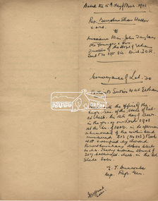 Eltham District Historical Society Inc
Document, Certificate of Consent of Sale of Lot 20 Henry Street, Eltham to Hope of Eltham Tent No. 195 Victoria District Independent Order of Rechabites, 28 Nov 1901
Alexander Robert Edgar, President of the Victoria and Tasmania Conference of the Wesleyan Methodist Church by Certificate of Consent of Sale dated 28 November 1901, declared that the Conference of the Church held in Melbourne, 27 February 1894, agreed to the sale by the Trustees of Lot 20 Henry Street. Indenture dated 15 November 1901 between Revd. Barnabas Shaw Walker, Minister of the Pentridge Circuit, Joseph Cooper, Gardener of Keelbundora, Samuel Jeffrey, Farmer of Jika Jika, John Brown, State School Teacher, Robert David Taylor, Gardener and Isaac Hill, Dealer, all of Eltham, the Trustees conveyed the land to William John Taylor the Younger, Gardener, George Knapman, Blacksmith and Isaac Hill junior, Carrier, all of Eltham and Trustees at the time for a Friendly Society known as the Hope of Eltham Tent No. 195 Victoria District Independent Order of Rechabites for the sum of £40. The conveyance was received into the Office of the Registrar General, State of Victoria, 12 December 1901. Originally purchased in 1856 from Thomas Roberts, Yeoman of Little Eltham, for £10 for use by the Wesleyan Chapel, represented by indentured Trustees, Rev. Barnabas Shaw Walker, Minister of the Pentridge Circuit, Francis Thomas, Farmer of Keelbundora, William Harriman, Blacksmith of Nillumbik, Nicholas Rodda, Farmer of Nillumbik, Aaron Grimshaw, Farmer of Greensborough, Joseph Cooper, Gardener of Keelbundora, Peter Dredge, Scholmaster of Jika Jika and Samuel Jeffrey, Farmer of Jika Jika. Lot 20 of Subdivision of Portion 13, Section 4 of the Parish of Nillumbik in the County of Evelyn was located on the southern side of Henry street in Little Eltham North, where the current Our Lady Help of Christians Catholic Church is situated. It became the location of the Eltham Rechabite Hall. In 1893 a new hall was built and further enlarged in 1919. At the commencement of 1922, the property was purchased from the Independent Order of Rechabites with publicly subscribed funds and a new hall built at a cost of £750 and improved road access constructed to reduce the grade, running from Dudley Street to Henry Street. This hall was eventually replaced with the new Shire Offices and Hall built on the corner of Arthur Street and Main Road, which was opened in 1941. Traces the earliest history of the Eltham Public Hall in Henry Street and the various names, occupations and abodes of the Trustees associated with the propertyaaron grimshaw, blacksmith, edmond perry, eltham public hall, eltham rechabite hall, eltham wesleyan chapel, francis thomas, george knapman, george smith, henry street, hope of eltham tent no. 195, i.w. lucas, isaac hill, james blanch, james chapman, james william brown, john brown, john jenkins peacock, john jones, john neale, john van mangerhoussen weiss, joseph cooper, joseph morris holloway, josiah atwool, keelbundora, lancelot iredale, little eltham, little eltham north, lizar elliott, mark blanchard, methodist church, nicholas rodda, p. mather, peter dredge, rev barnabas shaw walker, robert david taylor, samuel jeffrey, samuel moor munce, thomas roberts, thomas wheaten bowden, trustee, victoria district independent order of rechabites, wesleyan methodist church, william harriman, william hebblewhite, william john munce, william john taylor, william matthews, william rose -
 Eltham District Historical Society Inc
Document, Declaration of Trust as to The Eltham Hall, Lot 20 Henry Street, Eltham, 5 Aug 1922
William James Capewell, Ernest James Andrew and George Harrison all of Eltham collected the sum of £150 towards the purchase of Lot 20 Henry Street and whereby a Contract of Sale dated 30 December 1921 agreed to purchase (as Trustees of The Eltham Hall to be used in perpetuity for the benefit of the inhabitants of the Eltham District) the land, furniture, fittings and chattels from Jack Alfred Harrison, George Hugh Bird and Edward Samuel McColl for £750. The first President was declared to be Ernest James Andrew, Honorary Secretary, A.J. Morse, Honorary Treasurer, Charles Robert Nicholls and the first elective committee to be Thomas Nunn Jewell, William John Pasco, George Burchall, William James Burgess, John William Cox, Ernest James Andrew, John Michael Ryan, Frederick William Gillespie Didfield, Charles Harold Williams, Joseph Banks, Laurence Bourke, Charles Robert Nicholls, William James Capewell and James Pascal. This committee was appointed until the Annual meeting of subscribers held in January 1923 at which point all could stand for re-election (held annually). The Trust Deed was signed by Ernest James Andrew, William James Capewell and George Harrison in the presence of John Michael Ryan, Builder of Eltham, 5 August 1922. Originally purchased in 1856 from Thomas Roberts, Yeoman of Little Eltham, for £10 for use by the Wesleyan Chapel, represented by indentured Trustees, Rev. Barnabas Shaw Walker, Minister of the Pentridge Circuit, Francis Thomas, Farmer of Keelbundora, William Harriman, Blacksmith of Nillumbik, Nicholas Rodda, Farmer of Nillumbik, Aaron Grimshaw, Farmer of Greensborough, Joseph Cooper, Gardener of Keelbundora, Peter Dredge, Scholmaster of Jika Jika and Samuel Jeffrey, Farmer of Jika Jika. Lot 20 of Subdivision of Portion 13, Section 4 of the Parish of Nillumbik in the County of Evelyn was located on the southern side of Henry street in Little Eltham North, where the current Our Lady Help of Christians Catholic Church is situated. It became the location of the Eltham Rechabite Hall. In 1893 a new hall was built and further enlarged in 1919. At the commencement of 1922, the property was purchased from the Independent Order of Rechabites with publicly subscribed funds and a new hall built at a cost of £750 and improved road access constructed to reduce the grade, running from Dudley Street to Henry Street. This hall was eventually replaced with the new Shire Offices and Hall built on the corner of Arthur Street and Main Road, which was opened in 1941. Traces the earliest history of the Eltham Public Hall in Henry Street and the various names, occupations and abodes of the Trustees associated with the propertya.j. morse, charles harold williams, charles robert nicholls, edward samuel mccoll, eltham public hall, eltham rechabite hall, eltham wesleyan chapel, ernest james andrew, frederick william gillespie didfield, george burchall, george harrison, george hugh bird, henry street, jack alfred harrison, james pascal, john michael ryan, john william cox, joseph banks, laurence bourke, thomas nunn jewell, trustee, william james burgess, william james capewell, william john pasco -
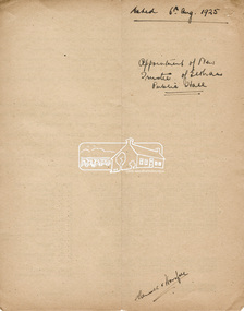 Eltham District Historical Society Inc
Document, Appointment of new Trustee for Eltham Public Hall, Lot 20 Henry Street, Eltham, 6 Aug 1925
Indenture made 6 August 1925 between Ernest James Andrew, News Agent, Cyril Robert Nicholls, Grocer, John Michael Ryan, Builder, Ellen Matilda Andrew, Married Woman, Alice Maude Bourke, Spinster, Mary Ellen Birchall, Married Woman, Adeline Gertrude Phillips, Married Woman, Minnie Maria Isherwood, Married Woman, Florence Garner, Spinster, Ethel Boake, Married Woman, Edith Marion Bowman, Married Woman, Clarice Armstrong, Spinster, Annie Ryan, Married Woman, William Pasco, Gentleman, Thomas Bowman, Printer, Arthur Copeland Christopherson, Grocer, Thomas Nunan Jewell, Carpenter all of Eltham (the Committee of The Eltham Hall) and William James Capewell, Butcher and Ernest James Andrew both of Eltham and Trustees for The Eltham Hall and George Birchall, Hatter of Eltham to be appointed a Trustee in lieu of George Harrison who requested to be discharged as a Trustee. Originally purchased in 1856 from Thomas Roberts, Yeoman of Little Eltham, for £10 for use by the Wesleyan Chapel, represented by indentured Trustees, Rev. Barnabas Shaw Walker, Minister of the Pentridge Circuit, Francis Thomas, Farmer of Keelbundora, William Harriman, Blacksmith of Nillumbik, Nicholas Rodda, Farmer of Nillumbik, Aaron Grimshaw, Farmer of Greensborough, Joseph Cooper, Gardener of Keelbundora, Peter Dredge, Scholmaster of Jika Jika and Samuel Jeffrey, Farmer of Jika Jika. Lot 20 of Subdivision of Portion 13, Section 4 of the Parish of Nillumbik in the County of Evelyn was located on the southern side of Henry street in Little Eltham North, where the current Our Lady Help of Christians Catholic Church is situated. It became the location of the Eltham Rechabite Hall. In 1893 a new hall was built and further enlarged in 1919. At the commencement of 1922, the property was purchased from the Independent Order of Rechabites with publicly subscribed funds and a new hall built at a cost of £750 and improved road access constructed to reduce the grade, running from Dudley Street to Henry Street. This hall was eventually replaced with the new Shire Offices and Hall built on the corner of Arthur Street and Main Road, which was opened in 1941. Traces the earliest history of the Eltham Public Hall in Henry Street and the various names, occupations and abodes of the Trustees associated with the propertyadeline gertrude phillips, alice maude bourke, annie ryan, arthur copeland christopherson, clarice armstrong, cyril robert nicholls, edith marion bowman, ellen matilda andrew, eltham public hall, eltham rechabite hall, eltham wesleyan chapel, ernest james andrew, ethel boake, florence garner, george birchall, george harrison, grocer, henry street, john michael ryan, mary ellen birchall, minnie maria isherwood, thomas bowman, thomas nunan jewell, trustee, william james capewell, william pasco -
 Eltham District Historical Society Inc
Document, Conveyance, Lot 20 Henry Street, Eltham, Hope of Eltham Tent No. 195 I.O.R. to W.J. Capewell and others, 31 Dec 1926
Indenture between Jack Alfred Harrison, Accountant, Edward Samuel McColl, Council Employee, both of Eltham and William Wilson, Coachbuilder of Research, the Trustees of a certain Friendly Society known as The Hope of Eltham Tent No. 195 Victorian District I.O.R of the one part and William James Capewell, Butcher, Ernest James Andrew, News Agent and George Birchall, Hatter all of Eltham of the other part, Trustees for The Eltham Hall, for the purchase of Lot 20 Henry Street for £750. Witnessed by Hubert James Carter J.P for Jack Alfred Harrison, A.H.C. Price J.P. for Edward Samuel McColl and J. Webster J.P. for William Wilson. Originally purchased in 1856 from Thomas Roberts, Yeoman of Little Eltham, for £10 for use by the Wesleyan Chapel, represented by indentured Trustees, Rev. Barnabas Shaw Walker, Minister of the Pentridge Circuit, Francis Thomas, Farmer of Keelbundora, William Harriman, Blacksmith of Nillumbik, Nicholas Rodda, Farmer of Nillumbik, Aaron Grimshaw, Farmer of Greensborough, Joseph Cooper, Gardener of Keelbundora, Peter Dredge, Scholmaster of Jika Jika and Samuel Jeffrey, Farmer of Jika Jika. Lot 20 of Subdivision of Portion 13, Section 4 of the Parish of Nillumbik in the County of Evelyn was located on the southern side of Henry street in Little Eltham North, where the current Our Lady Help of Christians Catholic Church is situated. It became the location of the Eltham Rechabite Hall. In 1893 a new hall was built and further enlarged in 1919. At the commencement of 1922, the property was purchased from the Independent Order of Rechabites with publicly subscribed funds and a new hall built at a cost of £750 and improved road access constructed to reduce the grade, running from Dudley Street to Henry Street. This hall was eventually replaced with the new Shire Offices and Hall built on the corner of Arthur Street and Main Road, which was opened in 1941. Traces the earliest history of the Eltham Public Hall in Henry Street and the various names, occupations and abodes of the Trustees associated with the property -
 Eltham District Historical Society Inc
Document, Conveyance of Lot 20 Henry Street, Little Eltham North to Trustees of Wesleyan Chapel, 1856
Originally purchased in 1856 from Thomas Roberts, Yeoman of Little Eltham, for £10 for use by the Wesleyan Chapel, represented by indentured Trustees, Rev. Barnabas Shaw Walker, Minister of the Pentridge Circuit, Francis Thomas, Farmer of Keelbundora, William Harriman, Blacksmith of Nillumbik, Nicholas Rodda, Farmer of Nillumbik, Aaron Grimshaw, Farmer of Greensborough, Joseph Cooper, Gardener of Keelbundora, Peter Dredge, Scholmaster of Jika Jika and Samuel Jeffrey, Farmer of Jika Jika. Lot 20 of Subdivision of Portion 13, Section 4 of the Parish of Nillumbik in the County of Evelyn was located on the southern side of Henry street in Little Eltham North, where the current Our Lady Help of Christians Catholic Church is situated. It became the location of the Eltham Rechabite Hall. In 1893 a new hall was built and further enlarged in 1919. At the commencement of 1922, the property was purchased from the Independent Order of Rechabites with publicly subscribed funds and a new hall built at a cost of £750 and improved road access constructed to reduce the grade, running from Dudley Street to Henry Street. This hall was eventually replaced with the new Shire Offices and Hall built on the corner of Arthur Street and Main Road, which was opened in 1941. Traces the earliest history of the Eltham Public Hall in Henry Street and the various names, occupations and abodes of the Trustees associated with the propertyaaron grimshaw, blacksmith, edmond perry, eltham public hall, eltham rechabite hall, eltham wesleyan chapel, francis thomas, george smith, henry street, i.w. lucas, james blanch, james chapman, james william brown, john jenkins peacock, john jones, john neale, john van mangerhoussen weiss, joseph cooper, joseph morris holloway, josiah atwool, keelbundora, lancelot iredale, little eltham, lizar elliott, mark blanchard, methodist church, nicholas rodda, p. mather, peter dredge, rev barnabas shaw walker, samuel jeffrey, samuel moor munce, thomas roberts, thomas wheaten bowden, william harriman, william hebblewhite, william john munce, william matthews, william rose -
 Eltham District Historical Society Inc
Document, Certificate as to Trustees of Wesleyan Church land, Lot 20 Henry Street, Little Eltham North, 7 Oct 1901
The Trustees for Lot 20 Henry Street were declared by the Wesleyan Methodist Church on 7 October 1901 to be Revd. Barnabas Shaw Walker, Minister of the Pentridge Circuit, Joseph Cooper, Gardener of Keelbundora, Samuel Jeffrey, Farmer of Jika Jika, Francis Thomas, Farmer of Doncaster and sometime of Keelbundora, John Brown, State School Teacher, William John Taylor, Gardener, Robert David Taylor, Gardener and Isaac Hill, Dealer, all of Eltham. Originally purchased in 1856 from Thomas Roberts, Yeoman of Little Eltham, for £10 for use by the Wesleyan Chapel, represented by indentured Trustees, Rev. Barnabas Shaw Walker, Minister of the Pentridge Circuit, Francis Thomas, Farmer of Keelbundora, William Harriman, Blacksmith of Nillumbik, Nicholas Rodda, Farmer of Nillumbik, Aaron Grimshaw, Farmer of Greensborough, Joseph Cooper, Gardener of Keelbundora, Peter Dredge, Scholmaster of Jika Jika and Samuel Jeffrey, Farmer of Jika Jika. Lot 20 of Subdivision of Portion 13, Section 4 of the Parish of Nillumbik in the County of Evelyn was located on the southern side of Henry street in Little Eltham North, where the current Our Lady Help of Christians Catholic Church is situated. It became the location of the Eltham Rechabite Hall. In 1893 a new hall was built and further enlarged in 1919. At the commencement of 1922, the property was purchased from the Independent Order of Rechabites with publicly subscribed funds and a new hall built at a cost of £750 and improved road access constructed to reduce the grade, running from Dudley Street to Henry Street. This hall was eventually replaced with the new Shire Offices and Hall built on the corner of Arthur Street and Main Road, which was opened in 1941. Traces the earliest history of the Eltham Public Hall in Henry Street and the various names, occupations and abodes of the Trustees associated with the propertyeltham public hall, eltham rechabite hall, eltham wesleyan chapel, francis thomas, henry street, james abel marsland, james massland, john brown, joseph cooper, little eltham north, rev barnabas shaw walker, robert david taylor, samuel jeffrey, trustee, william john taylor, little eltham, isaac hill -
 Eltham District Historical Society Inc
Document - Folder, Shallard family
Jack and Mary Emma Shallard and their three children, Bill, Joyce and Jack, moved to the Eltham area around 1912. Jack married Blanche Everard and lived in Montmorency and was active in community matters. Contents Photocopy page, October 1920, re Eltham, noting Joseph Bromley Shallard as a Councillor for Eltham. Photograph: Eltham Historical Society display at home of Joy and Bruce Ness 1987, Les Robertson, Jack Shallard, Blanche Shallard and Margorie North. Photograph: Eltham Historical Society float, Eltham Festival Parade 1988, Blanche Shallard, Opal Smith and Eileen Gibbon. Manuscript and typed notes, no date: Memories of Eltham and district by Jack Shallard Newspaper article: "Jack Shallard will be sadly missed", Diamond Valley News, 18 June 1991. Obituary of Jack Shallard. Letter Elizabeth Pidgeon to Eltham District Historical Society, 20 March 2001: Seeking information on Shallard family of Eltham, provides information on Roberts and Tinker families. Newspaper death notice for Blanche Shallard, The Age, 12 September 2002. Newspaper funeral notice for Blanche Shallard, The Age, 13 September 2002. Order of Service: Blanche Emily Shallard, St Faith's Anglican Church, Montmorency, 13 September 2002. Eulogies for Blanche Shallard by Jan Mullins, Kerry Knowles, and grandchildren of Blanche Shallard. Letter Sue Law to the Shallard family, 15 September 2002. Acknowledging contribution of Blanche Shallard to EDHS and seeking copies of eulogies. Newspaper article: "Community honours a favourite resident", Diamond Valley Leader, 20 November 2002. Obituary of Blanche Emily Shallard with photograph. Notes, undated, of Sue Law's recollections from Blanche Shallard. Newspaper advertisement: "63 and 65 Rattray Road, Montmorency", Diamond Valley News, no date. For sale 63 and 65 Rattray Road, Montmorency. Newspaper advertisement: "63 and 65 Rattray Road, Montmorency", Diamond Valley Leader, 12 March 2003. Auction 5 April of 63 and 65 Rattray Road, Montmorency.Newspaper clippings, A4 photocopies, etcjoseph shallard, mary emma shallard nee tinker, elizabeth ann tinker nee roberts, susan shallard nee roberts, james roberts, sarah roberts nee pope, joseph bromley shallard, william shallard, joseph tinker, jack vincent shallard, jocelyn shallard, christopher shallard, elsie shallard nee mills, meruka house sherbourne road, mary north, jack shallard, blanche shallard nee everard, bill everard, eltham primary school, melbourne high school, university of melbourne, holy trinity church of england kew, st margaret's church of england eltham, st faith's church of england montmorency, best hooper rintoul and shallard, diamond valley community hospital, blanche emily shallard nee everard, 63-65 rattray road montmorency, jan mullins, kerry knowles, joy neww, bruche ness, les robertson, marjorie north, eltham festical parade 1988, opal smith, eileen gibbon, joyce shallard, falkiner street eltham, bridge street eltham, karingal drive montmorency, sherbourne road montmorency, "kaweka" sherbourne road montmorency, greensborough road eltham, eltham state school, rechabites hill henry street eltham, eltham hotel, boy scouts troup eltham, eltham district cricket association, first world war memorial tltham, eltham railway station -
 Eltham District Historical Society Inc
Document, Appointment of New Trustees, Eltham Public Hall, Lot 20 Henry Street, Eltham, 1940
Draft of Indenture made __ day of __ 1940 between William Allen, Nurseryman, Ernest James Andrew, Gentleman, Ronald Walter Bradbury, Medical Practioner, Robert Sutherland Bryan, John Neville Burgoyne, Grocer, James Francis Cresp, Frederick Haines Collis, Grocer, William Hickey, Harold Claude Hutchison, David Andrew Lyon, Garage Proprietior, Albert E. Parsons, James Clyde Rains, News Agent, Eric Nicholl Staff, Store-keeper and William Walker, Plumber all of Eltham in the State of Victoria and Anton William Brinkkotter, Poultry Farmer in the said State and Sidney William Browne, Hotel Proprietor of Lower Plenty and Robert David Taylor, Secretary of Rosanna (the Committee) to appoint John Neville Burgoyne, William Hickey and David Andrew Lyon as Trustees to replace William James Capewell, Ernest James Andrew and George Birchall. William James Capewell, Butcher and Ernest James Andrew, News Agent and both of Eltham and George Harrison were the original Trustees appointed in the Declaration of Trust dated 5 August 1922. George Birchall replaced George Harrison 6 August 1925 but after being absent from the State for more than two years and William James Capewell and Ernest James Andrew desirous of being discharged as Trustees, under the power of appointing new Trustees vested in the Committee, the Committee resolved on 14 November 1935 that Albert Henry Charles Price, Cecil Martin and Albert John Fahle should be Trustees in place of George Birchall, Ernest James Andrew and William James Capewell however the said resolution was never carried into effect and the said writing was never completed. Subsequently in 1940 Albert Henry Charles Price, Cecil Martin and Albert John Fahle each resigned in writing as Trustees even though never appointed and so the Committee appointed John Neville Burgoyne, William Hickey and David Andrew Lyon as Trustees in place of William James Capewell, Ernest James Andrew and George Birchall. Originally purchased in 1856 from Thomas Roberts, Yeoman of Little Eltham, for £10 for use by the Wesleyan Chapel, represented by indentured Trustees, Rev. Barnabas Shaw Walker, Minister of the Pentridge Circuit, Francis Thomas, Farmer of Keelbundora, William Harriman, Blacksmith of Nillumbik, Nicholas Rodda, Farmer of Nillumbik, Aaron Grimshaw, Farmer of Greensborough, Joseph Cooper, Gardener of Keelbundora, Peter Dredge, Scholmaster of Jika Jika and Samuel Jeffrey, Farmer of Jika Jika. Lot 20 of Subdivision of Portion 13, Section 4 of the Parish of Nillumbik in the County of Evelyn was located on the southern side of Henry street in Little Eltham North, where the current Our Lady Help of Christians Catholic Church is situated. It became the location of the Eltham Rechabite Hall. In 1893 a new hall was built and further enlarged in 1919. At the commencement of 1922, the property was purchased from the Independent Order of Rechabites with publicly subscribed funds and a new hall built at a cost of £750 and improved road access constructed to reduce the grade, running from Dudley Street to Henry Street. This hall was eventually replaced with the new Shire Offices and Hall built on the corner of Arthur Street and Main Road, which was opened in 1941. Traces the earliest history of the Eltham Public Hall in Henry Street and the various names, occupations and abodes of the Trustees associated with the propertyalbert e. parsons, albert henry charles price, albert john fahle, anton william brinkkotter, cecil martin, david andrew lyon, eltham public hall, eltham rechabite hall, eltham wesleyan chapel, eric nicholl staff, ernest james andrew, frederick haines collis, george birchall, grocer, harold claude hutchison, henry street, james clyde rains, james francis cresp, john neville burgoyne, robert david taylor, robert sutherland bryan, ronald walter bradbury, sidney william browne, trustee, william allen, william hickey, william james capewell, william walker -
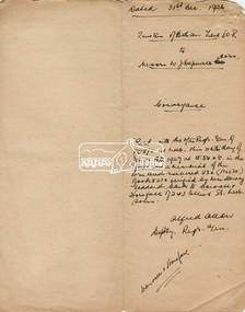
 Eltham District Historical Society Inc
Document, Declaration of Trustees, Eltham Public Hall, Lot 20 Henry Street, Eltham, 18 Mar 1927
Robert David Taylor of Eltham declared he was the Secretary of a certain Friendly Society known as the Hope of Eltham Tent No. 195 Victoria District of the Independent Order of Rechabites; that William John Taylor the Younger, George Knapman and Isaac Hill junior the Purchasers mentioned and described in a certain Indenture of Conveyance from Barnabas Shaw Walker and others also therein described registered in the office of the Registrar General were at the time of the registration of the said Conveyance the trustees of the said Friendly Society and purchased the land and hereditaments described in the Conveyance as such Trustees; and that Edward Samuel McColl, Jack Alfred Harrison and William Wilson were on 31 December 1926 the trustees of the said Friendly Society and as such were entitled to grant and convey the land and hereditaments described in the said Indenture of Conveyance. Originally purchased in 1856 from Thomas Roberts, Yeoman of Little Eltham, for £10 for use by the Wesleyan Chapel, represented by indentured Trustees, Rev. Barnabas Shaw Walker, Minister of the Pentridge Circuit, Francis Thomas, Farmer of Keelbundora, William Harriman, Blacksmith of Nillumbik, Nicholas Rodda, Farmer of Nillumbik, Aaron Grimshaw, Farmer of Greensborough, Joseph Cooper, Gardener of Keelbundora, Peter Dredge, Scholmaster of Jika Jika and Samuel Jeffrey, Farmer of Jika Jika. Lot 20 of Subdivision of Portion 13, Section 4 of the Parish of Nillumbik in the County of Evelyn was located on the southern side of Henry street in Little Eltham North, where the current Our Lady Help of Christians Catholic Church is situated. It became the location of the Eltham Rechabite Hall. In 1893 a new hall was built and further enlarged in 1919. At the commencement of 1922, the property was purchased from the Independent Order of Rechabites with publicly subscribed funds and a new hall built at a cost of £750 and improved road access constructed to reduce the grade, running from Dudley Street to Henry Street. This hall was eventually replaced with the new Shire Offices and Hall built on the corner of Arthur Street and Main Road, which was opened in 1941. Traces the earliest history of the Eltham Public Hall in Henry Street and the various names, occupations and abodes of the Trustees associated with the propertyedward samuel mccoll, eltham public hall, eltham rechabite hall, eltham wesleyan chapel, george knapman, henry street, hope of eltham tent no. 195, isaac hill junior, jack alfred harrison, trustee, victoria district independent order of rechabites, william john taylor the younger, william wilson -
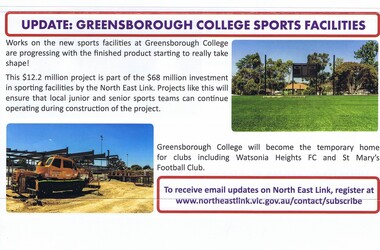 Greensborough Historical Society
Article - Newsletter Clipping, Colin Brooks, Update: Greensborough College sports facilities, 2021
... during the building of the North East Link. greensborough college ...Article from Brooksy's Briefing about works on the new sports facilities at Greensborough College which will temporarily house Watsonia Heights Football Club and St Mary's Football Club during the building of the North East Link.Newsletter article, text with two colour imagesgreensborough college, colin brooks, north east link, watsonia heights football club, st marys football club -
 Eltham District Historical Society Inc
Photograph - Digital Photograph, Alan King, Pauline Toner Butterfly Reserve, 2008
One of seven sites in Eltham and Greensborough where the butterfly survives. Published: Nillumbik Now and Then / Marguerite Marshall 2008; photographs Alan King with Marguerite Marshall.; p181 The rare Eltham Copper Butterfly, Paralucia pyro-discus, was saved from near extinction by a community campaign in the late 1980s. Thanks to that effort, the butterfly, a form of the Fiery Copper Butterfly, with a wing span of only 2.5cm, can be seen in parts of Eltham and Greensborough from late November to April. As late as 1987 the butterfly was thought to be near extinction. But that year, entomologist, Michael Braby, found several colonies, including two major ones in natural bushland on Diosma Road, Eltham. However these were threatened with destruction, as their habitat was to be destroyed by a development of 71 houses. The colonies were on a 14 hectare subdivision owned by Esanda Finance, an ANZ Bank subsidiary. It would cost around $5 million, to reimburse the bank for the land. The butterfly, which depends on woodland, a stunted form of the Sweet Bursaria bush, and the Notoncus ant, was considered too fragile to relocate. Braby’s discovery led to a sometimes fiery two-year campaign, which even became an election issue. It involved the local community, local and state governments and the developer, before a compromise was reached. The larvae have an intricate relationship with the small black ant, Notoncus. During the day, the larvae shelter in nests made by the ants around the base of the trunk and roots of the Sweet Bursaria (Bursaria spinosa). The ants are thought to protect the larvae from predators and parasites, as they attend them from the nests to feed on the Bursaria leaves at night. In return, the larvae excrete a sugar solution, which the ants love to eat. The butterfly was first recorded in Victoria in 1893, and first collected scientifically from Eltham in 1931. But it was only officially named in 1951, by Victoria’s then top butterfly expert, David Crosby.2 However, from 1970, rapid housing development in Eltham destroyed much of the butterfly’s habitat. The discovery of several major colonies in 1987 met with great excitement, and 250 people attended the first local public meeting. The State Government commissioned Crosby to investigate how to protect the butterfly, and the council froze development for three weeks. Then Esanda agreed to suspend development for several months, until a compromise was reached. Crosby recommended that 62 of the 71 lots be kept to ensure the butterflys’ survival. However this would cost $1 million to $1.5million in compensation to Esanda. Greensborough MP Pauline Toner, launched a $1million fundraising campaign and many artists donated their works to the appeal. Toner offered Clifton Pugh’s painting Eltham Copper Country to millionaire Alan Bond for $1 million, after having heard that he had offered $6 million for the Van Gough painting Sunflowers. However Bond did not accept. The butterfly was considered a ‘hot’ election issue during the by-election, following Pauline Toner’s resignation. Liberal party candidate, Margaret Brown, was accused of falsely saying she had been involved in the butterfly campaign so as to win votes. Sadly, the $1million appeal fell short at $426,000, so a compromise was reached. The State Government donated the Education Department site on Eucalyptus Road, but only nine lots of the Diosma site were bought, and the rest of the development went ahead. On March 3, 1989, Ms Toner died. Thee Eucalyptus Road site was named in her honour. Around 2000 the butterfly was further threatened by proposed developments on Pitt Street, facing the Pauline Toner Reserve and between Diosma and Nyora Roads. Fortunately the Friends of the ECB, with the Shire of Nillumbik, ensured that more habitat was made available. The butterfly now survives in seven sites in Eltham and Greensborough, including the main sites at the Pauline Toner Reserve on Eucalyptus Road, the Western and Eastern colonies on Diosma Road, and the Yandell Reserve in Greensborough.5 The butterfly survives also in Castlemaine and in the Kiata and Salisbury areas. However, it remains endangered.This collection of almost 130 photos about places and people within the Shire of Nillumbik, an urban and rural municipality in Melbourne's north, contributes to an understanding of the history of the Shire. Published in 2008 immediately prior to the Black Saturday bushfires of February 7, 2009, it documents sites that were impacted, and in some cases destroyed by the fires. It includes photographs taken especially for the publication, creating a unique time capsule representing the Shire in the early 21st century. It remains the most recent comprehenesive publication devoted to the Shire's history connecting local residents to the past. nillumbik now and then (marshall-king) collection, eltham copper butterfly, pauline toner butterfly reserve -
 Eltham District Historical Society Inc
Photograph - Digital Photograph, Alan King, Sweet Bursaria, 2008
Published: Nillumbik Now and Then / Marguerite Marshall 2008; photographs Alan King with Marguerite Marshall.; p181 The rare Eltham Copper Butterfly, Paralucia pyro-discus, was saved from near extinction by a community campaign in the late 1980s. Thanks to that effort, the butterfly, a form of the Fiery Copper Butterfly, with a wing span of only 2.5cm, can be seen in parts of Eltham and Greensborough from late November to April. As late as 1987 the butterfly was thought to be near extinction. But that year, entomologist, Michael Braby, found several colonies, including two major ones in natural bushland on Diosma Road, Eltham. However these were threatened with destruction, as their habitat was to be destroyed by a development of 71 houses. The colonies were on a 14 hectare subdivision owned by Esanda Finance, an ANZ Bank subsidiary. It would cost around $5 million, to reimburse the bank for the land. The butterfly, which depends on woodland, a stunted form of the Sweet Bursaria bush, and the Notoncus ant, was considered too fragile to relocate. Braby’s discovery led to a sometimes fiery two-year campaign, which even became an election issue. It involved the local community, local and state governments and the developer, before a compromise was reached. The larvae have an intricate relationship with the small black ant, Notoncus. During the day, the larvae shelter in nests made by the ants around the base of the trunk and roots of the Sweet Bursaria (Bursaria spinosa). The ants are thought to protect the larvae from predators and parasites, as they attend them from the nests to feed on the Bursaria leaves at night. In return, the larvae excrete a sugar solution, which the ants love to eat. The butterfly was first recorded in Victoria in 1893, and first collected scientifically from Eltham in 1931. But it was only officially named in 1951, by Victoria’s then top butterfly expert, David Crosby.2 However, from 1970, rapid housing development in Eltham destroyed much of the butterfly’s habitat. The discovery of several major colonies in 1987 met with great excitement, and 250 people attended the first local public meeting. The State Government commissioned Crosby to investigate how to protect the butterfly, and the council froze development for three weeks. Then Esanda agreed to suspend development for several months, until a compromise was reached. Crosby recommended that 62 of the 71 lots be kept to ensure the butterflys’ survival. However this would cost $1 million to $1.5million in compensation to Esanda. Greensborough MP Pauline Toner, launched a $1million fundraising campaign and many artists donated their works to the appeal. Toner offered Clifton Pugh’s painting Eltham Copper Country to millionaire Alan Bond for $1 million, after having heard that he had offered $6 million for the Van Gough painting Sunflowers. However Bond did not accept. The butterfly was considered a ‘hot’ election issue during the by-election, following Pauline Toner’s resignation. Liberal party candidate, Margaret Brown, was accused of falsely saying she had been involved in the butterfly campaign so as to win votes. Sadly, the $1million appeal fell short at $426,000, so a compromise was reached. The State Government donated the Education Department site on Eucalyptus Road, but only nine lots of the Diosma site were bought, and the rest of the development went ahead. On March 3, 1989, Ms Toner died, and the Eucalyptus Road site was named in her honour. Around 2000 the butterfly was further threatened by proposed developments on Pitt Street, facing the Pauline Toner Reserve and between Diosma and Nyora Roads. Fortunately the Friends of the ECB, with the Shire of Nillumbik, ensured that more habitat was made available. The butterfly now survives in seven sites in Eltham and Greensborough, including the main sites at the Pauline Toner Reserve on Eucalyptus Road, the Western and Eastern colonies on Diosma Road, and the Yandell Reserve in Greensborough.The butterfly survives also in Castlemaine and in the Kiata and Salisbury areas. However, it remains endangered.This collection of almost 130 photos about places and people within the Shire of Nillumbik, an urban and rural municipality in Melbourne's north, contributes to an understanding of the history of the Shire. Published in 2008 immediately prior to the Black Saturday bushfires of February 7, 2009, it documents sites that were impacted, and in some cases destroyed by the fires. It includes photographs taken especially for the publication, creating a unique time capsule representing the Shire in the early 21st century. It remains the most recent comprehenesive publication devoted to the Shire's history connecting local residents to the past. nillumbik now and then (marshall-king) collection, eltham copper butterfly, sweet bursaria -
 Greensborough Historical Society
Article - Newsletter Clipping, Colin Brooks, St Mary's Primary School hall refurbishment now open, June 2024
Article from Brooksy's Briefing about St Mary's Primary School's refurbished hall thanks to school fundraising and a North East Link Community Grant.Newsletter article text with colour imagest. mary's primary school, colin brooks, st marys parish greensborough, st marys primary school -
 Melbourne Tram Museum
Ephemera - Timetable - bus - The Met - set of 24, The Met, 1992 & 1993
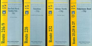
SSet of 24 The Met bus timetables, with diagrammatic map, major stops and contact details. All dated during1993 unless noted otherwise. 1 - Route 216/9 - Deer Park West & Sunshine Park - City 2 - Route 220 - Sunshine - City - 1992 3 - Route 232 - Altona North - City - 1992 4 - Route 233 - Fishermens Bend - City - 1992 5 - Route 254 - Northland Shopping Centre - City - 1992 6 - Route 256 - La Trobe Uni - City - 1992 7 - Routes 258 & 259 - Northland Shopping Centre, and La Trobe Uni - City via Eastern Freeway - 1992 8 - Route 260 etc - Deep Creek Templestow - Donvale - City 9 - Route 264 - Mitcham, Donvale City 10 - Route 265 - Deep Creek - City 11 - Route 602 - Brighton - city 12 - Route 269, 291 and 296 - Greensborough, Heidelberg & Newmans Road to Box Hill 13 - Route 272 - Warrandyte - City 14 - Route 276 & 278 - Warrandyte - City 15 - Route 284 & 270 - East Kew - City or Box Hill 16 - Route 285 - The Pines - Box Hill 17 - Route 286 & 288 - The Pines and Templestowe - Box Hill 18 - Route 290 - North Nunawading - Box Hill 19 - Route 292 etc - Box Hill, Deep Creek, Ringwood, Warrandyte 20 - Route 301, 281 315 - Ringwood, Park Orchards and Donvale - City 21 - Route 305 - Box Hill - Ringwood 22 - Route 366 & 367 - Ringwood - Croydon 23 - Route 600 - St Kilda - Brighton Beach - 1992 24 - Route 601 - Gardenvale - City - 1992Yields information about some of The Met bus services 1993Set of 24 The Met timetables, DL size, printed in two colours.timetables, the met, route 216, route 220, route 232, route 233, route 254, route 258, route 259, route 260, route 264, route 265, route 256, route 602, route 269, route 272, route 276, route 284, route 270, route 285, route 286, route 288, route 290, route 292, route 301, route 305, route 366, route 367, route 600, route 601 -
Greensborough Historical Society
Leaflet, Road changes: Greensborough and Watsonia March 2019, 2019_03
Outline of proposed changes to the plan for roads around the Old Greensborough Road and Watsonia Station areas1 p. leaflet printed in colour both sides north east link, watsonia station, old greensborough road watsonia -
 Greensborough Historical Society
Book - Annual Report, Diamond Valley Football League, Diamond Valley Football League. Annual Report. Season 1994, 1994
A complete record of the DVFL season 1994, includes financial report, description of events, membership, teams, scores from the seasons games and winners of best and fairest awards for all divisions and age groups. including black and white photos. In 1994 the Division 1 Premiers were North Heidelberg Football Club.This annual report covers many teams from within the Diamond Valley area. Includes junior and senior teams.Foolscap size book. 188 pages, printed on double sides of pages. Orange, White & Blue cover with black text and includes typed tables and black and white photosaustralian rules football, greensborough football club, diamond valley football league, dvfl, northern football league, nfl, northern football netball league, nfnl, north heidelberg football club -
 Eltham District Historical Society Inc
Photograph, Looking north across the Fitzsimons Lane Bridge over Yarra River between Eltham and Templestowe, c.1985, 1985c
Turnoff to Candlebark Park on right. The bridge over the Yarra River was initially opened September 22nd, 1961. Newspaper reports at the time of opening stated it linked Bolton Street, Eltham, with Fitzsimons Lane, Templestowe. In 1955 the Country Roads Board (CRB) produced survey plans that showed proposed land acquisition for the future bridge and road approaches. The 1955 plan shows that it was proposed to connect Fitzsimons Lane with Bolton Street in Eltham by a diagonal road across the river. The road connection would then continue along Bolton Street to Main Road. Prior to construction of the bridge the CRB modified the proposal significantly so that there was a new road parallel with Bolton Street and then curving to join Main Road at what was then its intersection with Old Eltham Road. This involved significantly more land acquisition and altered the pattern of land subdivision through this corridor. Initially the new road was just a single two-way carriageway as it would have required a significant widening of the cutting on the Shire of Eltham side of the river. The road was officially un-named but was known locally as the Eltham-Templestowe Road. The 1966 Melway street directory and other 1960s editions also listed the road as the Eltham-Templestowe Road. In December 1970, Eltham Shire Council, in pursuance of the provisions of the Local Government Act, named it Templestowe Road. The road was renamed Fitzsimons Lane around 1984 in conformity with the section south of the river. In 1991 a new bridge was built to the west of the original bridge. Fitzsimons Lane was widened to four traffic lanes although on the Eltham side this was done within the limits of the existing cutting. NEW BRIDGE STARTS THEM EXPLORING Without any fanfares, Country Roads Board workmen on Friday afternoon put the finishing touches to the approaches, removed the barricades, and let the traffic roll over the new Yarra bridge linking Bolton Street, Eltham, with Fitzsimons Lane, Templestowe. Over the week-end many “bridge watchers” who were making one of their periodic inspections of the progress on the new bridge found to their surprise that they could drive over it, so that people who had gone for a run out to Eltham suddenly found themselves wandering through Templestowe and Doncaster. By Monday the word of the bridge’s opening had got around sufficiently for many regular travellers to the city from Eltham and beyond to vary the monotony by going to town via Templestowe and Kew instead of through Heidelberg. They were surprised at the distances – about 3 ½ miles from Eltham to Templestowe, 6 miles from Eltham Shire hall to the Lower Heidelberg Road-Banksia Street intersection. NEW NEIGHBOURS For people on both sides of the river, the new bridge has turned distant friends into near neighbours. A Greensborough man on Sunday took 35 minutes to reach the home of a friend in East Doncaster, but the return trip over the new bridge took only 17 minutes. It will be some time yet before most people work out the possibilities in shorter and quicker trips form the north-eastern areas to the eastern and south-eastern suburbs. The coming of the warmer months will soon teach many, though the short cuts to Peninsular beaches and eastern suburban drive-ins. And before very long it is likely there will be a Tramways bus running from Templestowe to Eltham station. NEW BRIDGE STARTS THEM EXPLORING (1961, September 27). The Diamond Valley News (News clipping held in SEA_74-1_047) The previously un-named road between Main Road and Yarra River, Eltham South, east of Bolton Street was named Templestowe Road, December 15, 1970 NAMING OF STREETS AND ROADS. (1970, December 15). The Diamond Valley News (News clipping held in SEA_74-2_022)Colour photographinfrastructure, shire of eltham infrastructure, bridge, fitzsimons lane bridge, yarra river, candlebark park, red nose day -
 Eltham District Historical Society Inc
Photograph, Fitzsimons Lane Bridge over Yarra River between Eltham and Templestowe
The bridge over the Yarra River was initially opened September 22nd, 1961. Newspaper reports at the time of opening stated it linked Bolton Street, Eltham, with Fitzsimons Lane, Templestowe. In 1955 the Country Roads Board (CRB) produced survey plans that showed proposed land acquisition for the future bridge and road approaches. The 1955 plan shows that it was proposed to connect Fitzsimons Lane with Bolton Street in Eltham by a diagonal road across the river. The road connection would then continue along Bolton Street to Main Road. Prior to construction of the bridge the CRB modified the proposal significantly so that there was a new road parallel with Bolton Street and then curving to join Main Road at what was then its intersection with Old Eltham Road. This involved significantly more land acquisition and altered the pattern of land subdivision through this corridor. Initially the new road was just a single two-way carriageway as it would have required a significant widening of the cutting on the Shire of Eltham side of the river. The road was officially un-named but was known locally as the Eltham-Templestowe Road. The 1966 Melway street directory and other 1960s editions also listed the road as the Eltham-Templestowe Road. In December 1970, Eltham Shire Council, in pursuance of the provisions of the Local Government Act, named it Templestowe Road. The road was renamed Fitzsimons Lane around 1984 in conformity with the section south of the river. In 1991 a new bridge was built to the west of the original bridge. Fitzsimons Lane was widened to four traffic lanes although on the Eltham side this was done within the limits of the existing cutting. NEW BRIDGE STARTS THEM EXPLORING Without any fanfares, Country Roads Board workmen on Friday afternoon put the finishing touches to the approaches, removed the barricades, and let the traffic roll over the new Yarra bridge linking Bolton Street, Eltham, with Fitzsimons Lane, Templestowe. Over the week-end many “bridge watchers” who were making one of their periodic inspections of the progress on the new bridge found to their surprise that they could drive over it, so that people who had gone for a run out to Eltham suddenly found themselves wandering through Templestowe and Doncaster. By Monday the word of the bridge’s opening had got around sufficiently for many regular travellers to the city from Eltham and beyond to vary the monotony by going to town via Templestowe and Kew instead of through Heidelberg. They were surprised at the distances – about 3 ½ miles from Eltham to Templestowe, 6 miles from Eltham Shire hall to the Lower Heidelberg Road-Banksia Street intersection. NEW NEIGHBOURS For people on both sides of the river, the new bridge has turned distant friends into near neighbours. A Greensborough man on Sunday took 35 minutes to reach the home of a friend in East Doncaster, but the return trip over the new bridge took only 17 minutes. It will be some time yet before most people work out the possibilities in shorter and quicker trips form the north-eastern areas to the eastern and south-eastern suburbs. The coming of the warmer months will soon teach many, though the short cuts to Peninsular beaches and eastern suburban drive-ins. And before very long it is likely there will be a Tramways bus running from Templestowe to Eltham station. NEW BRIDGE STARTS THEM EXPLORING (1961, September 27). The Diamond Valley News (News clipping held in SEA_74-1_047) The previously un-named road between Main Road and Yarra River, Eltham South, east of Bolton Street was named Templestowe Road, December 15, 1970 NAMING OF STREETS AND ROADS. (1970, December 15). The Diamond Valley News (News clipping held in SEA_74-2_022)Black and white photographinfrastructure, shire of eltham infrastructure, bridge, fitzsimons lane bridge, yarra river -
 Eltham District Historical Society Inc
Photograph, Looking south across the Fitzsimons Lane Bridge over Yarra River between Eltham and Templestowe
The bridge over the Yarra River was initially opened September 22nd, 1961. Newspaper reports at the time of opening stated it linked Bolton Street, Eltham, with Fitzsimons Lane, Templestowe. In 1955 the Country Roads Board (CRB) produced survey plans that showed proposed land acquisition for the future bridge and road approaches. The 1955 plan shows that it was proposed to connect Fitzsimons Lane with Bolton Street in Eltham by a diagonal road across the river. The road connection would then continue along Bolton Street to Main Road. Prior to construction of the bridge the CRB modified the proposal significantly so that there was a new road parallel with Bolton Street and then curving to join Main Road at what was then its intersection with Old Eltham Road. This involved significantly more land acquisition and altered the pattern of land subdivision through this corridor. Initially the new road was just a single two-way carriageway as it would have required a significant widening of the cutting on the Shire of Eltham side of the river. The road was officially un-named but was known locally as the Eltham-Templestowe Road. The 1966 Melway street directory and other 1960s editions also listed the road as the Eltham-Templestowe Road. In December 1970, Eltham Shire Council, in pursuance of the provisions of the Local Government Act, named it Templestowe Road. The road was renamed Fitzsimons Lane around 1984 in conformity with the section south of the river. In 1991 a new bridge was built to the west of the original bridge. Fitzsimons Lane was widened to four traffic lanes although on the Eltham side this was done within the limits of the existing cutting. NEW BRIDGE STARTS THEM EXPLORING Without any fanfares, Country Roads Board workmen on Friday afternoon put the finishing touches to the approaches, removed the barricades, and let the traffic roll over the new Yarra bridge linking Bolton Street, Eltham, with Fitzsimons Lane, Templestowe. Over the week-end many “bridge watchers” who were making one of their periodic inspections of the progress on the new bridge found to their surprise that they could drive over it, so that people who had gone for a run out to Eltham suddenly found themselves wandering through Templestowe and Doncaster. By Monday the word of the bridge’s opening had got around sufficiently for many regular travellers to the city from Eltham and beyond to vary the monotony by going to town via Templestowe and Kew instead of through Heidelberg. They were surprised at the distances – about 3 ½ miles from Eltham to Templestowe, 6 miles from Eltham Shire hall to the Lower Heidelberg Road-Banksia Street intersection. NEW NEIGHBOURS For people on both sides of the river, the new bridge has turned distant friends into near neighbours. A Greensborough man on Sunday took 35 minutes to reach the home of a friend in East Doncaster, but the return trip over the new bridge took only 17 minutes. It will be some time yet before most people work out the possibilities in shorter and quicker trips form the north-eastern areas to the eastern and south-eastern suburbs. The coming of the warmer months will soon teach many, though the short cuts to Peninsular beaches and eastern suburban drive-ins. And before very long it is likely there will be a Tramways bus running from Templestowe to Eltham station. NEW BRIDGE STARTS THEM EXPLORING (1961, September 27). The Diamond Valley News (News clipping held in SEA_74-1_047) The previously un-named road between Main Road and Yarra River, Eltham South, east of Bolton Street was named Templestowe Road, December 15, 1970 NAMING OF STREETS AND ROADS. (1970, December 15). The Diamond Valley News (News clipping held in SEA_74-2_022)Black and white photographinfrastructure, shire of eltham infrastructure, bridge, fitzsimons lane bridge, yarra river -
 Eltham District Historical Society Inc
Photograph, Fitzsimons Lane Bridge over Yarra River between Eltham and Templestowe
The bridge over the Yarra River was initially opened September 22nd, 1961. Newspaper reports at the time of opening stated it linked Bolton Street, Eltham, with Fitzsimons Lane, Templestowe. In 1955 the Country Roads Board (CRB) produced survey plans that showed proposed land acquisition for the future bridge and road approaches. The 1955 plan shows that it was proposed to connect Fitzsimons Lane with Bolton Street in Eltham by a diagonal road across the river. The road connection would then continue along Bolton Street to Main Road. Prior to construction of the bridge the CRB modified the proposal significantly so that there was a new road parallel with Bolton Street and then curving to join Main Road at what was then its intersection with Old Eltham Road. This involved significantly more land acquisition and altered the pattern of land subdivision through this corridor. Initially the new road was just a single two-way carriageway as it would have required a significant widening of the cutting on the Shire of Eltham side of the river. The road was officially un-named but was known locally as the Eltham-Templestowe Road. The 1966 Melway street directory and other 1960s editions also listed the road as the Eltham-Templestowe Road. In December 1970, Eltham Shire Council, in pursuance of the provisions of the Local Government Act, named it Templestowe Road. The road was renamed Fitzsimons Lane around 1984 in conformity with the section south of the river. In 1991 a new bridge was built to the west of the original bridge. Fitzsimons Lane was widened to four traffic lanes although on the Eltham side this was done within the limits of the existing cutting. NEW BRIDGE STARTS THEM EXPLORING Without any fanfares, Country Roads Board workmen on Friday afternoon put the finishing touches to the approaches, removed the barricades, and let the traffic roll over the new Yarra bridge linking Bolton Street, Eltham, with Fitzsimons Lane, Templestowe. Over the week-end many “bridge watchers” who were making one of their periodic inspections of the progress on the new bridge found to their surprise that they could drive over it, so that people who had gone for a run out to Eltham suddenly found themselves wandering through Templestowe and Doncaster. By Monday the word of the bridge’s opening had got around sufficiently for many regular travellers to the city from Eltham and beyond to vary the monotony by going to town via Templestowe and Kew instead of through Heidelberg. They were surprised at the distances – about 3 ½ miles from Eltham to Templestowe, 6 miles from Eltham Shire hall to the Lower Heidelberg Road-Banksia Street intersection. NEW NEIGHBOURS For people on both sides of the river, the new bridge has turned distant friends into near neighbours. A Greensborough man on Sunday took 35 minutes to reach the home of a friend in East Doncaster, but the return trip over the new bridge took only 17 minutes. It will be some time yet before most people work out the possibilities in shorter and quicker trips form the north-eastern areas to the eastern and south-eastern suburbs. The coming of the warmer months will soon teach many, though the short cuts to Peninsular beaches and eastern suburban drive-ins. And before very long it is likely there will be a Tramways bus running from Templestowe to Eltham station. NEW BRIDGE STARTS THEM EXPLORING (1961, September 27). The Diamond Valley News (News clipping held in SEA_74-1_047) The previously un-named road between Main Road and Yarra River, Eltham South, east of Bolton Street was named Templestowe Road, December 15, 1970 NAMING OF STREETS AND ROADS. (1970, December 15). The Diamond Valley News (News clipping held in SEA_74-2_022)Black and white photographinfrastructure, shire of eltham infrastructure, bridge, fitzsimons lane bridge, yarra river -
 Greensborough Historical Society
Poster - Planning Document, Shire of Diamond Valley et al, Subdivision Plan # 1018 - Parish of Nillumbik, County Bourke, Crown Allotment 4 Section 15, and Crown Allotment B Section 12, Eltham North, 1981-1982
Subdivision Plan # 1018 - Parish of Nillumbik, County Bourke, Crown Allotment 4 Section 15, and Crown Allotment B Section 12, Eltham North. This subdivision plan includes Ryans Road (also known as Government Road) and St Clems Street. The developer for this subdivision is Taunton Developments and the Surveyors are Fisher Cleeland Turner & Dwyer Vic, Surveyors and Engineers.An example of hard copy subdivision plans from the Greensborough area. Mainly from the Shire of Diamond Valley era (1964-1994).Plan (single sided) mounted on heavy card. Stamped and handwritten Council permissions, dates and other details. subdivision plans, shire of diamond valley, taunton developments -
 Greensborough Historical Society
Poster - Planning Document, Shire of Diamond Valley et al, Subdivision Plan # 1026 - Parish of Nillumbik, County Bourke, Crown Allotment B Section 12, Eltham North, 1981-1984
Subdivision Plan # 1026 - Parish of Nillumbik, County Bourke, Crown Allotment B Section 12, Eltham North. This subdivision plan includes Ryans Road (also known as Government Road) and St Clems Street. The developer for this subdivision is Taunton Developments and the Surveyors are Fisher Cleeland Turner & Dwyer Vic, Surveyors and Engineers.An example of hard copy subdivision plans from the Greensborough area. Mainly from the Shire of Diamond Valley era (1964-1994).Plan (single sided) mounted on heavy card. Stamped and handwritten Council permissions, dates and other details. subdivision plans, shire of diamond valley, taunton developments -
 Greensborough Historical Society
Poster - Planning Document, Shire of Diamond Valley et al, Subdivision Plan # 1044 - Parish of Nillumbik, County Bourke, Crown Allotment B Section 12, Eltham North, 1981-1987
Subdivision Plan # 1044 - Parish of Nillumbik, County Bourke, Crown Allotment B Section 12, Eltham North. This subdivision plan includes Weidlich Road and St Clems Street. The developer for this subdivision is Taunton Developments and the Surveyors are Fisher Cleeland Turner & Dwyer Vic, Surveyors and Engineers.An example of hard copy subdivision plans from the Greensborough area. Mainly from the Shire of Diamond Valley era (1964-1994).Plan (single sided) mounted on heavy card. Stamped and handwritten Council permissions, dates and other details. subdivision plans, shire of diamond valley, taunton developments -
 Eltham District Historical Society Inc
Photograph, Russell Yeoman, Fitzsimons Lane Bridge over Yarra River between Eltham and Templestowe, c.1970, 1970c
The bridge over the Yarra River was initially opened September 22nd, 1961. Newspaper reports at the time of opening stated it linked Bolton Street, Eltham, with Fitzsimons Lane, Templestowe. In 1955 the Country Roads Board (CRB) produced survey plans that showed proposed land acquisition for the future bridge and road approaches. The 1955 plan shows that it was proposed to connect Fitzsimons Lane with Bolton Street in Eltham by a diagonal road across the river. The road connection would then continue along Bolton Street to Main Road. Prior to construction of the bridge the CRB modified the proposal significantly so that there was a new road parallel with Bolton Street and then curving to join Main Road at what was then its intersection with Old Eltham Road. This involved significantly more land acquisition and altered the pattern of land subdivision through this corridor. Initially the new road was just a single two-way carriageway as it would have required a significant widening of the cutting on the Shire of Eltham side of the river. The road was officially un-named but was known locally as the Eltham-Templestowe Road. The 1966 Melway street directory and other 1960s editions also listed the road as the Eltham-Templestowe Road. In December 1970, Eltham Shire Council, in pursuance of the provisions of the Local Government Act, named it Templestowe Road. The road was renamed Fitzsimons Lane around 1984 in conformity with the section south of the river. In 1991 a new bridge was built to the west of the original bridge. Fitzsimons Lane was widened to four traffic lanes although on the Eltham side this was done within the limits of the existing cutting. NEW BRIDGE STARTS THEM EXPLORING Without any fanfares, Country Roads Board workmen on Friday afternoon put the finishing touches to the approaches, removed the barricades, and let the traffic roll over the new Yarra bridge linking Bolton Street, Eltham, with Fitzsimons Lane, Templestowe. Over the week-end many “bridge watchers” who were making one of their periodic inspections of the progress on the new bridge found to their surprise that they could drive over it, so that people who had gone for a run out to Eltham suddenly found themselves wandering through Templestowe and Doncaster. By Monday the word of the bridge’s opening had got around sufficiently for many regular travellers to the city from Eltham and beyond to vary the monotony by going to town via Templestowe and Kew instead of through Heidelberg. They were surprised at the distances – about 3 ½ miles from Eltham to Templestowe, 6 miles from Eltham Shire hall to the Lower Heidelberg Road-Banksia Street intersection. NEW NEIGHBOURS For people on both sides of the river, the new bridge has turned distant friends into near neighbours. A Greensborough man on Sunday took 35 minutes to reach the home of a friend in East Doncaster, but the return trip over the new bridge took only 17 minutes. It will be some time yet before most people work out the possibilities in shorter and quicker trips form the north-eastern areas to the eastern and south-eastern suburbs. The coming of the warmer months will soon teach many, though the short cuts to Peninsular beaches and eastern suburban drive-ins. And before very long it is likely there will be a Tramways bus running from Templestowe to Eltham station. NEW BRIDGE STARTS THEM EXPLORING (1961, September 27). The Diamond Valley News (News clipping held in SEA_74-1_047) The previously un-named road between Main Road and Yarra River, Eltham South, east of Bolton Street was named Templestowe Road, December 15, 1970 NAMING OF STREETS AND ROADS. (1970, December 15). The Diamond Valley News (News clipping held in SEA_74-2_022)Roll of 35mm black and white negative film, 4 of 7 stripsIlford HP4bridge, bridges, fitzsimons lane bridge, infrastructure, shire of eltham infrastructure, yarra river -
 Eltham District Historical Society Inc
Photograph, Fitzsimons Lane Bridge over Yarra River between Eltham and Templestowe, c.1966, 1966c
The bridge over the Yarra River was initially opened September 22nd, 1961. Newspaper reports at the time of opening stated it linked Bolton Street, Eltham, with Fitzsimons Lane, Templestowe. In 1955 the Country Roads Board (CRB) produced survey plans that showed proposed land acquisition for the future bridge and road approaches. The 1955 plan shows that it was proposed to connect Fitzsimons Lane with Bolton Street in Eltham by a diagonal road across the river. The road connection would then continue along Bolton Street to Main Road. Prior to construction of the bridge the CRB modified the proposal significantly so that there was a new road parallel with Bolton Street and then curving to join Main Road at what was then its intersection with Old Eltham Road. This involved significantly more land acquisition and altered the pattern of land subdivision through this corridor. Initially the new road was just a single two-way carriageway as it would have required a significant widening of the cutting on the Shire of Eltham side of the river. The road was officially un-named but was known locally as the Eltham-Templestowe Road. The 1966 Melway street directory and other 1960s editions also listed the road as the Eltham-Templestowe Road. In December 1970, Eltham Shire Council, in pursuance of the provisions of the Local Government Act, named it Templestowe Road. The road was renamed Fitzsimons Lane around 1984 in conformity with the section south of the river. In 1991 a new bridge was built to the west of the original bridge. Fitzsimons Lane was widened to four traffic lanes although on the Eltham side this was done within the limits of the existing cutting. NEW BRIDGE STARTS THEM EXPLORING Without any fanfares, Country Roads Board workmen on Friday afternoon put the finishing touches to the approaches, removed the barricades, and let the traffic roll over the new Yarra bridge linking Bolton Street, Eltham, with Fitzsimons Lane, Templestowe. Over the week-end many “bridge watchers” who were making one of their periodic inspections of the progress on the new bridge found to their surprise that they could drive over it, so that people who had gone for a run out to Eltham suddenly found themselves wandering through Templestowe and Doncaster. By Monday the word of the bridge’s opening had got around sufficiently for many regular travellers to the city from Eltham and beyond to vary the monotony by going to town via Templestowe and Kew instead of through Heidelberg. They were surprised at the distances – about 3 ½ miles from Eltham to Templestowe, 6 miles from Eltham Shire hall to the Lower Heidelberg Road-Banksia Street intersection. NEW NEIGHBOURS For people on both sides of the river, the new bridge has turned distant friends into near neighbours. A Greensborough man on Sunday took 35 minutes to reach the home of a friend in East Doncaster, but the return trip over the new bridge took only 17 minutes. It will be some time yet before most people work out the possibilities in shorter and quicker trips form the north-eastern areas to the eastern and south-eastern suburbs. The coming of the warmer months will soon teach many, though the short cuts to Peninsular beaches and eastern suburban drive-ins. And before very long it is likely there will be a Tramways bus running from Templestowe to Eltham station. NEW BRIDGE STARTS THEM EXPLORING (1961, September 27). The Diamond Valley News (News clipping held in SEA_74-1_047) The previously un-named road between Main Road and Yarra River, Eltham South, east of Bolton Street was named Templestowe Road, December 15, 1970 NAMING OF STREETS AND ROADS. (1970, December 15). The Diamond Valley News (News clipping held in SEA_74-2_022)Black and white photographManufacturer's marks: Polaroid, Batch #J62K181 (Sep 1966).infrastructure, shire of eltham infrastructure, bridge, fitzsimons lane bridge, polaroid, yarra river -
 Eltham District Historical Society Inc
Photograph, Fitzsimons Lane Bridge over Yarra River between Eltham and Templestowe, c.1966, 1966c
The bridge over the Yarra River was initially opened September 22nd, 1961. Newspaper reports at the time of opening stated it linked Bolton Street, Eltham, with Fitzsimons Lane, Templestowe. In 1955 the Country Roads Board (CRB) produced survey plans that showed proposed land acquisition for the future bridge and road approaches. The 1955 plan shows that it was proposed to connect Fitzsimons Lane with Bolton Street in Eltham by a diagonal road across the river. The road connection would then continue along Bolton Street to Main Road. Prior to construction of the bridge the CRB modified the proposal significantly so that there was a new road parallel with Bolton Street and then curving to join Main Road at what was then its intersection with Old Eltham Road. This involved significantly more land acquisition and altered the pattern of land subdivision through this corridor. Initially the new road was just a single two-way carriageway as it would have required a significant widening of the cutting on the Shire of Eltham side of the river. The road was officially un-named but was known locally as the Eltham-Templestowe Road. The 1966 Melway street directory and other 1960s editions also listed the road as the Eltham-Templestowe Road. In December 1970, Eltham Shire Council, in pursuance of the provisions of the Local Government Act, named it Templestowe Road. The road was renamed Fitzsimons Lane around 1984 in conformity with the section south of the river. In 1991 a new bridge was built to the west of the original bridge. Fitzsimons Lane was widened to four traffic lanes although on the Eltham side this was done within the limits of the existing cutting. NEW BRIDGE STARTS THEM EXPLORING Without any fanfares, Country Roads Board workmen on Friday afternoon put the finishing touches to the approaches, removed the barricades, and let the traffic roll over the new Yarra bridge linking Bolton Street, Eltham, with Fitzsimons Lane, Templestowe. Over the week-end many “bridge watchers” who were making one of their periodic inspections of the progress on the new bridge found to their surprise that they could drive over it, so that people who had gone for a run out to Eltham suddenly found themselves wandering through Templestowe and Doncaster. By Monday the word of the bridge’s opening had got around sufficiently for many regular travellers to the city from Eltham and beyond to vary the monotony by going to town via Templestowe and Kew instead of through Heidelberg. They were surprised at the distances – about 3 ½ miles from Eltham to Templestowe, 6 miles from Eltham Shire hall to the Lower Heidelberg Road-Banksia Street intersection. NEW NEIGHBOURS For people on both sides of the river, the new bridge has turned distant friends into near neighbours. A Greensborough man on Sunday took 35 minutes to reach the home of a friend in East Doncaster, but the return trip over the new bridge took only 17 minutes. It will be some time yet before most people work out the possibilities in shorter and quicker trips form the north-eastern areas to the eastern and south-eastern suburbs. The coming of the warmer months will soon teach many, though the short cuts to Peninsular beaches and eastern suburban drive-ins. And before very long it is likely there will be a Tramways bus running from Templestowe to Eltham station. NEW BRIDGE STARTS THEM EXPLORING (1961, September 27). The Diamond Valley News (News clipping held in SEA_74-1_047) The previously un-named road between Main Road and Yarra River, Eltham South, east of Bolton Street was named Templestowe Road, December 15, 1970 NAMING OF STREETS AND ROADS. (1970, December 15). The Diamond Valley News (News clipping held in SEA_74-2_022)Black and white photographManufacturer's marks: Polaroid, Batch #J62K181 (Sep 1966).infrastructure, shire of eltham infrastructure, bridge, fitzsimons lane bridge, polaroid, yarra river