Showing 469 items
matching public reserve
-
 Friends of Ballarat Botanical Gardens History Group
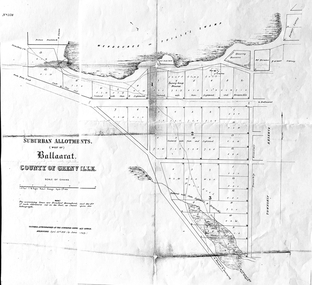
Work on paper - Suburban Allotments (west of) Ballaarat, Wendouree or Yuille's Swamp, County of Grenville 30/4/1856, 30/4/1856. No date given for photocopy
This map of the 1856 survey shows the numbered suburban allotments and the boundaries surrounding this area including Wendouree or Yuilles's Swamp close to where the Ballarat Botanical Gardens and the Lake exist today. This map gives a clear idea of an early survey of this western area and directions to areas of Ballarat surrounding these allotments.2 pages of the same map, except p.2 shows the Township Reserve on the lefthand side of the page. On the back of p.2, righthand corner is the Public Records Stamp.P2, righthand corner is the citation in pencil.john garner, doctor john garner, ballarat botanical gardens, friends of ballarat botanical gardens, map of western suburban allotments 1856, county of grenville, public record office of victoria, john garner collection, gardens, ballarat -
 Tarnagulla History Archive
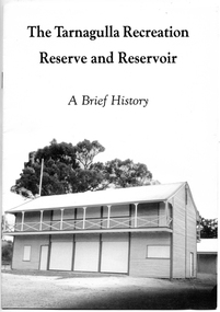
Booklet: The Tarnagulla Recreation Reserve and Reservoir, A Brief History, 1990
David Gordon Collection. Compiled by the Committee of Management of the Tarnagulla Recreation Parks in 1990. -
 Tarnagulla History Archive
Booklet: The Tarnagulla Recreation Reserve and Reservoir, A Brief History, 1990
David Gordon Collection. Compiled by the Committee of Management of the Tarnagulla Recreation Parks in 1990. -
 Tarnagulla History Archive
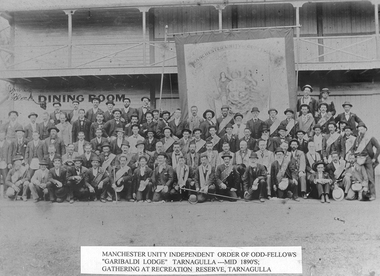
Photograph - Photograph: Members of Manchester Unity Oddfellows, at Tarnagulla, mid 1890s
Williams Family Collection. Monochrome photograph of members of Manchester Unity Oddfellows in full regalia, with banner behind, assembled at Tarnagulla Recreation Reserve. An original photograph, mounted on card. According to information on reverse, subject indicated by arrow is James Alexander Black, who was killed in the Yorkshire Mine at Tarnagulla on Good Friday 1899. Handwritten on back: 'L. Williams' and 'James Alexander Black. Killed in the Yorkshire Mine at Tarnagulla on Good Friday 1899'. Handwritten on front: 'James Alexander Black'tarnagulla, people, mining -
 Tarnagulla History Archive
Photograph: Members of M.U.I.O.O.F (Garibaldi Lodge) of Tarnagulla, 1890s
Donald Clark Collection. A monochrome photograph of men posed in front of a large wooden building. All are members of Manchester Unity Independent Order of Oddfellows (Garibaldi Lodge) of Tarnagulla. They are posed in their Lodge regalia with a large banner in front of the wooden pavillion which still stands at the Tarnagulla Recreation Reserve. Good quality copy photograph. Written in pen on image: 'James Black' or 'Block' and arrow pointing to man in left end of second back row.tarnagulla, lodge, garibaldi, ioof, manchester unity, societies, men -
 Tarnagulla History Archive
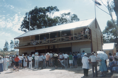
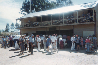
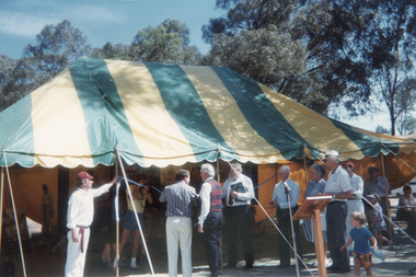
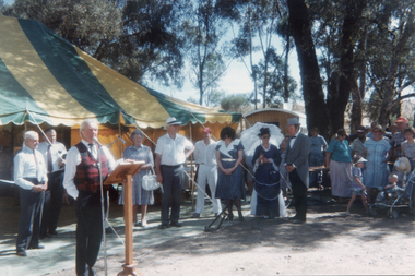
Photograph: Opening of restored pavillion at Tarnagulla Recreation Reserve, 1st December, 1990
Donald Clark Collection. A colour photograph depicting a ceremony for the re-opening of restored pavillion at Tarnagulla Recreation Reserve Original photograph. -
 Tarnagulla History Archive
Photograph: Opening of restored pavillion at Tarnagulla Recreation Reserve, 1st December, 1990
Donald Clark Collection. A colour photograph depicting a ceremony for the re-opening of restored pavillion at Tarnagulla Recreation Reserve Original photograph. -
 Tarnagulla History Archive
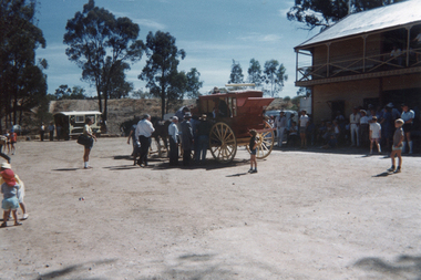
Photograph: Opening of restored pavillion at Tarnagulla Recreation Reserve, 1st December, 1990
Donald Clark Collection. A colour photograph depicting a Cobb & Co coach at the event for re-opening of restored pavillion at Tarnagulla Recreation Reserve Original photograph. -
 Tarnagulla History Archive
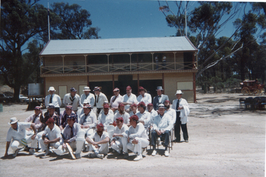
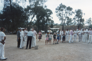
Photograph: Cricket teams at Tarnagulla Recreation Reserve, 1st December, 1990
Donald Clark Collection. A colour photograph depicting cricket teams at the event for re-opening of restored pavillion at Tarnagulla Recreation Reserve Original photograph. -
 Tarnagulla History Archive
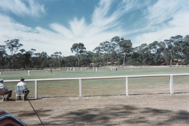
Photograph: Cricket match at Tarnagulla Recreation Reserve, 1st December, 1990
Donald Clark Collection. A colour photograph depicting a cricket match at the event for re-opening of restored pavillion at Tarnagulla Recreation Reserve Original photograph. -
 Tarnagulla History Archive
Photograph: Medal presentation at Tarnagulla Recreation Reserve, 1st December, 1990
Donald Clark Collection. A colour photograph depicting medal presentation after a cricket match at the event for re-opening of restored pavillion at Tarnagulla Recreation Reserve Original photograph. -
 Tarnagulla History Archive
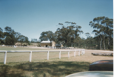
Photograph: Tarnagulla Recreation Reserve, 1st December, 1990
Donald Clark Collection. A colour photograph depicting Tarnagulla Recreation Reserve on the day of an event to re-open the restored pavillion. Original photograph. -
 Tarnagulla History Archive
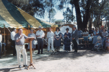
Photograph: Launch of Bet Bet & Korong Tourism Promotion, 1st December, 1990
Donald Clark Collection. A colour photograph depicting the launch of the Bet Bet & Korong Shire Tourism Promotion held at Tarnagulla Recreation Reserve. Held on the same day of re-opening the restored pavillion. Tom Roper at microphone. Original photograph. -
 Tarnagulla History Archive
Photograph: Launch of Bet Bet & Korong Tourism Promotion, 1st December, 1990
Donald Clark Collection. A colour photograph depicting the launch of the Bet Bet & Korong Shire Tourism Promotion held at Tarnagulla Recreation Reserve. Held on the same day of re-opening the restored pavillion. Original photograph. -
 Tarnagulla History Archive
Photograph: Launch of Bet Bet & Korong Tourism Promotion, 1st December, 1990
Donald Clark Collection. A colour photograph depicting the launch of the Bet Bet & Korong Shire Tourism Promotion held at Tarnagulla Recreation Reserve. Held on the same day of re-opening the restored pavillion. Lindsay Holt at microphone. Original photograph. -
 Tarnagulla History Archive
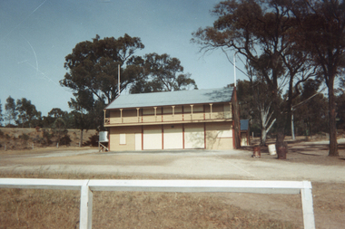
Photographs: Pavilion at Recreation Reserve, Tarnagulla, early 1990s
Donald Clark Collection. Two copies of a colour photograph depicting the pavilion at the Recreation Reserve, Tarnagulla. Original photograph. -
 Tarnagulla History Archive
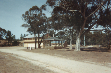
Photographs, Pavilion and bandstand at Recreation Reserve, Tarnagulla, early 1990s
Donald Clark Collection. Three copies of a colour photograph depicting the pavilion and bandstand at the Recreation Reserve, Tarnagulla. Original photograph. -
 Tarnagulla History Archive
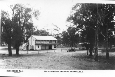
Postcard, Reids Series No.2 - The Reservoir Pavilion, Tarnagulla, circa 1920
Donald Clark Collection. A photographic copy of a monochrome postcard, depicting the Pavilion at the Tarnagulla Recreation Reserve. Titled: Reids Series No.2 - The Reservoir Pavilion, Tarnagulla Copy. -
Tarnagulla History Archive
'Two Historical Gatherings' by Don Clark, Donald Clark, 1988
Donald Clark Collection.Two copies of a typed first-hand account written by amateur historian Donald Clark about two gatherings which occurred in Tarnagulla to commemorate historic events. The first was a bonfire to celebrate Australia's Bi-centenary, held at the Tarnagulla Recreation Reserve on June 18th, 1988, also including unveiling of a plaque to mark the restoration of the band rotunda. The second was a celebration to commemorate the centenary of the 1888 opening of the railway line Dunolly to Inglewood, held on November 20th, 1988. -
Tarnagulla History Archive
Account of Bicentennial Bonfire at Tarnagulla, after 1988
Donald Clark Collection.A handwritten account of a Bicentennial Bonfire held at Tarnagulla Recreation Reserve. -
 Tarnagulla History Archive
Article: 'Tiny Town Is Big On History', 1990
Donald Clark Collection.Clipping from magazine (possibly Melbourne Cricket Club members newsletter), article titled 'Tiny Town Is Big On History'. About a commemorative cricket match played in Tarnagulla, between local residents and the MCC's XXIX Club, to celebrate the re-opening of the refurbished grandstand at Tarnagulla Recreation Reserve. sport, local history -
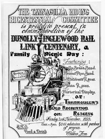 Tarnagulla History Archive
Poster: Dunolly-Ingelwood Rail Link Centenary Commemoration, 1988
Donald Clark Collection.Poster for a celebration commemorating the Centenary of the Dunolly-Ingelwood Rail Link, held at Tarnagulla Recreation Reserve on 20th November 1988. railway, rail -
Tarnagulla History Archive
Postcard - Photographic postcard: The Reservoir, Tarnagulla, c. 1900-1930
Williams Family Collection. Photographic postcard, front image depicting the water reservoir at Tarnagulla Recreation Reserve. tarnagulla -
Tarnagulla History Archive
Postcard - Photographic postcard: The Reservoir Pavilion, Tarnagulla, c. 1900-1930
Williams Family Collection. Photographic postcard. Reids Series No. 2. Front image depicting the pavilion and bandstand Tarnagulla Recreation Reserve. tarnagulla -
Tarnagulla History Archive
Photograph - Photograph: Gathering at Recreation Reserve for Back to Tarnagulla Reunion in 1937, 1937
Williams Family Collection. Monochrome photograph depicting people gathered at the Recreation Reserve for Back to Tarnagulla Reunion in 1937. Original photographic print. Handwritten on reverse: 'Recreation Ground Tarnagulla'.tarnagulla -
Tarnagulla History Archive
Photograph - Photograph: Reservoir jetty, Tarnagulla, c. 1925
Williams Family Collection. Photograph made by Charles Bock about 1925. Monochrome (sepia) photograph depicting degraded wooden jetty at the Reservoir in Tarnagulla Recreation Reserve. Unidentified person standing on jetty. Original photographic print. Stamp on reverse: 'Bock Print'.tarnagulla -
Tarnagulla History Archive
Booklet - Booklet: The Tarnagulla Recreation Reserve and Reservoir, The Tarnagulla Recreation Reserve and Reservoir, 1990
Paper history booklet on the Tarnagulla Recreation Reserve and Reservoir -
Tarnagulla History Archive
Photograph: Newbridge-Tarnagulla Gold Dig Walk, 2001
A small colour photograph depicting people gathered at Tarnagulla Recreation Reserve during the Newbridge-Tarnagulla Gold Dig Walk, 16 October 2001. -
Tarnagulla History Archive
Photograph: Newbridge-Tarnagulla Gold Dig Walk, 2001
A small colour photograph depicting people gathered at Tarnagulla Recreation Reserve during the Newbridge-Tarnagulla Gold Dig Walk, 16 October 2001. -
Tarnagulla History Archive
Photograph: Newbridge-Tarnagulla Gold Dig Walk, 2001
A small colour photograph depicting people gathered at Tarnagulla Recreation Reserve during the Newbridge-Tarnagulla Gold Dig Walk, 16 October 2001.