Showing 632 items
matching river st
-
 Kew Historical Society Inc
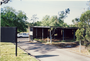
Photograph, Former Convent of the Good Shepherd, Abbotsford
The former Convent of the Good Shepherd at Abbotsford includes ecclesiastical, residential, educational and utility buildings constructed during the late nineteenth and twentieth centuries on a bend of the Yarra River. In 1975 the site was purchased by the Victorian Government as a higher education campus. A proposed redevelopment of the site in the late 1990s led to a community-based heritage battle which resulted in 2004 in the transfer of the convent site south of St Heliers Street to the Abbotsford Convent Foundation for community use. (Source: Heritage Victoria)This photograph is part of a series taken c.1990 by the photographer Rick Lowell. It was taken before the heritage campaign to preserve the site for community use.Colour snapshot of a part or section of the Former Convent of the Good Shepherd, Abbotsfordabbotsford convent, convent of the good shepherd, abbotsford (vic.) -
 Kew Historical Society Inc
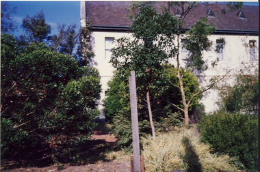
Photograph, Former Convent of the Good Shepherd, Abbotsford
The former Convent of the Good Shepherd at Abbotsford includes ecclesiastical, residential, educational and utility buildings constructed during the late nineteenth and twentieth centuries on a bend of the Yarra River. In 1975 the site was purchased by the Victorian Government as a higher education campus. A proposed redevelopment of the site in the late 1990s led to a community-based heritage battle which resulted in 2004 in the transfer of the convent site south of St Heliers Street to the Abbotsford Convent Foundation for community use. (Source: Heritage Victoria)This photograph is part of a series taken c.1990 by the photographer Rick Lowell. It was taken before the heritage campaign to preserve the site for community use.Colour snapshot of a part or section of the Former Convent of the Good Shepherd, Abbotsfordabbotsford convent, convent of the good shepherd, abbotsford (vic.) -
 Kew Historical Society Inc
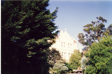
Photograph, Former Convent of the Good Shepherd, Abbotsford
The former Convent of the Good Shepherd at Abbotsford includes ecclesiastical, residential, educational and utility buildings constructed during the late nineteenth and twentieth centuries on a bend of the Yarra River. In 1975 the site was purchased by the Victorian Government as a higher education campus. A proposed redevelopment of the site in the late 1990s led to a community-based heritage battle which resulted in 2004 in the transfer of the convent site south of St Heliers Street to the Abbotsford Convent Foundation for community use. (Source: Heritage Victoria)This photograph is part of a series taken c.1990 by the photographer Rick Lowell. It was taken before the heritage campaign to preserve the site for community use.Colour snapshot of a part or section of the Former Convent of the Good Shepherd, Abbotsfordabbotsford convent, convent of the good shepherd, abbotsford (vic.) -
 Kew Historical Society Inc
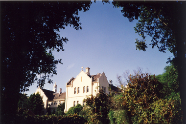
Photograph, Former Convent of the Good Shepherd, Abbotsford
The former Convent of the Good Shepherd at Abbotsford includes ecclesiastical, residential, educational and utility buildings constructed during the late nineteenth and twentieth centuries on a bend of the Yarra River. In 1975 the site was purchased by the Victorian Government as a higher education campus. A proposed redevelopment of the site in the late 1990s led to a community-based heritage battle which resulted in 2004 in the transfer of the convent site south of St Heliers Street to the Abbotsford Convent Foundation for community use. (Source: Heritage Victoria)This photograph is part of a series taken c.1990 by the photographer Rick Lowell. It was taken before the heritage campaign to preserve the site for community use.Colour snapshot of a part or section of the Former Convent of the Good Shepherd, Abbotsfordabbotsford convent, convent of the good shepherd, abbotsford (vic.) -
 Kew Historical Society Inc
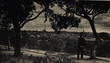
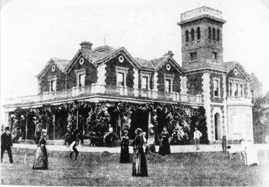
Photograph - Urban landscape, Henry Beater Christian, 1930s
Henry Christian (c.1809-91), the grandfather of the photographer, was one of the first settlers in Kew. He arrived in Victoria with his wife Agnes and son Orlando in 1855 on the Gypsy Queen. He established a rope-making business in Bulleen Road by 1858 but was declared insolvent two years later. In his final years, he was celebrated as one of the oldest living settlers of the district. His son, Orlando Henry Beater Christian (c.1853-1930) became a member of the Hawthorn Band and a foundation member of the Willsmere Swimming Club. Orlando and his wife Elizabeth had four children of which Henry Beater Christian (1886-1962) was the eldest.An item from an outstanding and diverse photographic collection, assembled by members of the Christian family of Pakington Street, Kew, comprising professional and amateur photography, depicting individuals, natural and settled environments and the interactions between these worlds. Many of the photographs vividly capture the worlds of three generations of men - Henry Christian, his son Orlando Henry Beater Christian, and his grandson of Henry Christian. The most important photographer was the youngest, Henry Christian, who was a keen explorer, not just of his immediate environment but also of the Victorian wilderness. His major opus is contained in two albums in which he records, sometimes in majestic detail and on other occasions the intimate features of the natural world. His photographic travels during the 1920s, often in solitary ramblings but on other occasions with companions, recall the heroic landscape photography of an earlier era, pioneered by Nicholas Caire. In addition to their aesthetic value, the albums are historically significant records within the State of Victoria, of what is now a distant point in time, and of places that have become radically altered through human intervention.Black and white photo of the rear view of a man in a hat standing under a tree on a hill looking across the Yarra River (unseen) towards Melbourne. The exhibition building and the spires of St Patrick’s Cathedral can be seen on the skyline. The man may be Orlando Henry Beater Christian. If all the spires are intact it must postdate 1939 when work begun in the early 1930s on the spires began. He may be standing on the edge of the Yarra Boulevard.melbourne skyline - 1930s, yarra boulevard -- kew (vic.), christian-washfold collection -
 Kew Historical Society Inc
Photograph - Yarra Valley Floods: Kew East, 1916
Flooding of the Yarra Valley, including that section of the Yarra bordering Kew and Kew East in the north and west of the municipality, was a regular occurrence. Extreme flood events of the Yarra River are recorded to have occurred in 1891, 1901, 1916, 1923 and 1934. The Municipality of Kew's response to these floods was to enact planning decisions restricting residential development in flood prone areas following the floods of 1916, 1921 and 1934. While floods continued after the development of the Upper Yarra Reservoir (construction 1948-57), the regularity and extent of these inundations diminished. During the nineteenth century, the land abutting the south side of the Yarra in Kew was devoted to dairy farming. In the twentieth century, before and after the construction of the Eastern Freeway, much of this low-lying area was used as golf courses and public parks.One of a collection of photographs of flooding in the Kew section of the Yarra Valley which are in important research resource for the location and extent of flooding in the first half of the twentieth century. Flooding of the Yarra Valley at East Kew in 1916. The view is taken from the intersection of Kilby Road with what is believed to be Birdwood Street, looking across the flood waters to Ivanhoe. The extensive flooded area shown in the photograph would have included the Kew Golf Club. Verso: "Floods along Kilby Road / near Birdwood St? & Kilby Road / 1917? / 87yarra river, yarra valley, floods -- kew, kilby road -- kew (vic.), kew golf club -
 Kew Historical Society Inc
Photograph - Flooding of the Yarra Valley at Kew East, 1974
Flooding of the Yarra Valley, including that section of the Yarra bordering Kew and Kew East in the north and west of the municipality, was a regular occurrence. Extreme flood events of the Yarra River are recorded to have occurred in 1891, 1901, 1916, 1923 and 1934. The Municipality of Kew's response to these floods was to enact planning decisions restricting residential development in flood prone areas following the floods of 1916, 1921 and 1934. While floods continued after the development of the Upper Yarra Reservoir (construction 1948-57), the regularity and extent of these inundations diminished. During the nineteenth century, the land abutting the south side of the Yarra in Kew was devoted to dairy farming. In the twentieth century, before and after the construction of the Eastern Freeway, much of this low-lying area was used as golf courses and public parks.Late example of the capacity of the Yarra Valley at Kew to flood, even though drainage works and the Upper Yarra Reservoir had reduced their regularity.Original black and white print photograph of the low-lying land at East Kew under floodwater on 16 May 1974. The vantage point of the photographer is Lister Street. Flooding was caused by overflowing water in Glass' Creek and the River Yarra. Annotation verso: "Lister St looking same as No.3 / 16 May 1974 11.30"floods, yarra river, glass' creek, lister street -
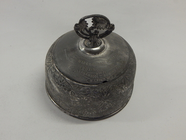 City of Warrnambool Rowing Club
Trophy, 1891
The Warrnambool Regatta was held on the Hopkins River on Sunday 27 December 1891. B. Laing rowed for the Warrnambool Rowing Club. A trophy was given to each member of the Maiden Four crew- A. Lumsden (bow), B. Laing (2), D. Rowan (3), J. Rowan (stroke), A. Geilhofer (cox). B. Laing was also a steward in the St John's Lodge.Brass bell shaped dome with a 4 cm circular hoop containing a tree motif.Warrnambool Regatta Boxing Day 1891 Maiden Four. Warrnambool Rowing Club. B. Laing No 2.trophy, warrnambool, 1891, rowing, hopkins river -
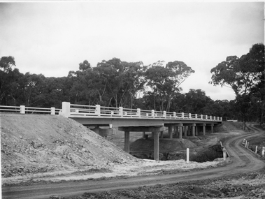 Stawell Historical Society Inc
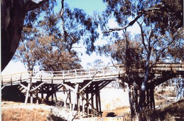
Photograph, Campbell’s Bridge over the Wimmera River 1961
Newly built Campbell’s Bridge over the Wimmera River. Built by Redman Bros. Opened in 1961.stawell shire -
 Stawell Historical Society Inc
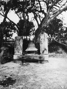
Photograph, Major Mitchell Trail Plaque near the Richardson River
Major Mitchell Trail Plaque Near Richardson Riverstawell -
 Stawell Historical Society Inc
Drawing, "Woodlands" Homestead on Wimmera River near Crowlands -- Drawing
Drawing of Woodlands Homestead on Wimmera River near Crowlands the seat of John Wilson Esqstawell -
 Stawell Historical Society Inc
Photograph, "Woodlands" Homestead on Wimmera River near Crowlands owned by William McCulloch 1894
Photograph of Woodlands Homestead on Wimmera River near Crowlands 1894 owned by William McCulloch when photo taken in 1894stawell -
 Stawell Historical Society Inc
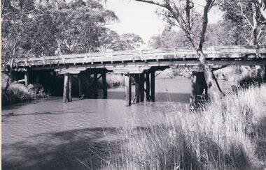
Photograph, Old Wooden Bridge - over the Wimmera River at Joel Joel -- Coloured
Wooden Bridge - Joel Joel (Wimmera River) stawell shire -
 Stawell Historical Society Inc
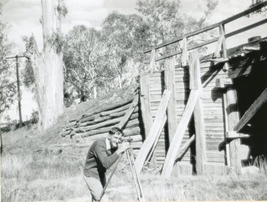
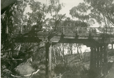
Photograph, Old Wooden Bridge - over the Wimmera River at Joel Joel being surveyed by Allan Rowe for a new bridge 1951
Old Wooden Bridge - Joel Joel (Wimmera River) 1951 being surveyed by Allan Rowe for new bridgestawell shire -
 Stawell Historical Society Inc
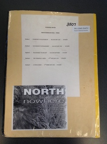
Book, Stawell Historical Society, North to Nowhere - The Wimmera River, 2002
stawell water -
 Stawell Historical Society Inc
Photograph, Wooden Wimmera River Bridge at Glenorchy -- 2 Photos
Two photographs of Wooden Wimmera River Bridge at Glenorchystawell -
 Stawell Historical Society Inc
Photograph, Old Campbells Bridge over Wimmera River
Old Campbells Bridge over Wimmera Riverstawell shire -
 Stawell Historical Society Inc
Photograph, Wooden Footbridge over the river in Glenorchy
Glenorchy Wooden Footbridge over Riverstawell -
Stawell Historical Society Inc
Archive - CD/DVD, Glenorchy Images (2) Glenorchy Historic Sites. Glenorchy, Footbridge, Four Posts Inn, Royal Mail Hotel, School, Street View, Wimmera River, Football Team, Railway Station, Cook& Sons Saddlers, Chas Lea Fruiterer, London Bank plus short histories, 2013/2014
stawell, glenorchy, streetscape -
 Melbourne's Living Museum of the West
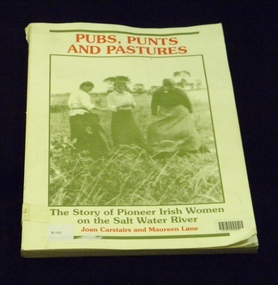
Book, St Albans History Society Inc, Pubs, Punts and Pastures, 1988
Tells the story of early Irish Pioneering Women who settled the Maribyrnong River Valley (formerly Salt Water River) and founded the first hotels, punts (river crossing barges) and farms in the region; and focuses on six particular women and their stories.Book now out of print. Funds from the sales of this book were used to build the monument "The Pioneer Womens Shelter" in Pipemakers Park.Book, soft card cover, 178 pagesISBN 0958808406 Book dedication "This book is dedicated to all women who made the voyage under sail"book, womens history, irish women, pioneers, maribyrnong river, salt water river -
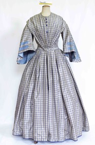 Brighton Historical Society
Clothing - Dress, Day dress, circa 1849
This dress was made for and belonged to Mrs Elizabeth McLachlan (nee Duncan, 1820-1904), wife of Reverend John Hamilton McLachlan (1813-1908), who was the first Minister of St Cuthbert's Presbyterian Church in Brighton. Elizabeth and John were married at the Free Church of Ayr at Lindsaystonn in the Parish of Kirkmickach, Ayrshire, Scotland on 15 October 1849. At this time his occupation was listed as "Minister of Presbyterian Church" and hers as "Governess". They left for Australia on the 1 November 1849 and arrived in Australia 6 months later. Apparently John's hair turned snow white during the journey due to his seasickness! The McLachlans first went to Geelong upon their arrival in 1850, then to the Western District, then Brighton, then Talbot at the height of the gold mining era. The couple had seven children: John Campbell Duncan McLachlan (b. Geelong, October 1850), Mary McLachlan (b. Geelong, November 1851), Agnes McLachlan (b. Hopkins River near Wickliff, May 1853), twins Elizabeth and Walter McLachlan (b. June 1854), Elizabeth McLachlan (b. Hesham, June 1855), Margaret McLachlan (b. Brighton, 1857). Elizabeth died in 1904. She and John are both buried in Amherst Cemetery. The dress was donated by one of her granddaughters. This circa 1849 silk blue grey window pane check dress features a high round neck and pleats on either shoulder extending over the natural shoulder line. The dress shows evidence of nine ornamental buttons down the centre front with only four blue silk buttons currently still attached. The dress fastens with thirteen concealed hook and eye closures to the waist. The Pagoda sleeves inset into the bodice in a small high armhole flaring out and finishing just below the elbow. A pale blue silk ribbon with a diagonal drawn stitch design decorates the front of the sleeve in a simple geometric design. The Pagoda sleeve is lined in a matching pale blue silk. The full skirt is pleated into the waistband and finishes just above the floor at the front. At the back the bodice features a squared off design to the princess panels shaping the dress into the body. The skirt is heavily pleated at the centre back into the waistline and finishes slightly longer at the back than the front. The skirt features two very small pockets on either side of the dress, just inside the hips. reverend john hamilton mclachlan, st cuthberts presbyterian church brighton, elizabeth mclachlan, amherst cemetery, 1840s fashion, brighton -
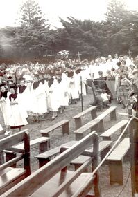 Port Fairy Historical Society Museum and Archives
Photograph
St John’s choir processing toward the river Blessing of the FleetBlack and white photograph St John’s choir in white robes with wide collars and mortar board style hats, wooden benches in forgroundevents, civil, ceremony, choir, st johns, blessing of the fleet, moyne river -
 University of Melbourne, Burnley Campus Archives
Plan, Burnley Gardens. City of Richmond. Parish of Jika Jika - County of Bourke, 1927
... and waterstops. Area bounded by Swan St. To N, Yarra River on E... and waterstops. Area bounded by Swan St. To N, Yarra River on E ...Part-coloured plan showing drainage, sewerage drains, taps and waterstops. Area bounded by Swan St. To N, Yarra River on E and Richmond Park on SW side. Contour lines of orchard depicted, laying pens and yards. Coloured area depicts pavilion with surrounding garden and paths layout pencilled in. Photo-Lithograph by Dept. of Lands & Survey, Melbourne by W. Butsonsewerage, drainage, lithograph, pavilion -
University of Melbourne, Burnley Campus Archives
Plan, Burnley Gardens. City of Richmond. Parish of Jika Jika - County of Bourke, 1927
... Plan showing Burnley Gardens - bounded by Swan St to N... Plan showing Burnley Gardens - bounded by Swan St to N, Yarra ...Plan showing Burnley Gardens - bounded by Swan St to N, Yarra River to E, Richmond Park on S and W side. Photo-lithographed at Dept. of Lands & Survey by W.J. Butson. Plan shows old orchard, fowl sheds, coops and yards, milking shed, silo, nursery, glasshouse, fattening pens, dairy, garden, orchards area in S.W. area.burnley gardens, orchards, sheds, nursery -
University of Melbourne, Burnley Campus Archives
Plan, Burnley Gardens. City of Richmond. Parish of Jika Jika - County of Bourke, 1927
... Plan showing Burnley Gardens - bounded by Swan St to N... Plan showing Burnley Gardens - bounded by Swan St to N, Yarra ...Plan showing Burnley Gardens - bounded by Swan St to N, Yarra River to E, Richmond Park on S and W side. Photo-lithographed at Dept of Lands & Survey by W.J. Butson. Plan shows old orchard, fowl sheds, coops and yards, milking shed, silo,nursery, glasshouse, fattening pens, gardens and orchards area in S.W. corner.burnley gardens, orchards, sheds, nursery -
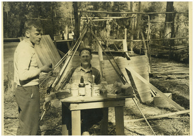 Falls Creek Historical Society
Photograph - Big River Survey Camp, c1949
MEYER COLLECTION - FALLS CREEK PHOTOS In 1947 a determined group of like-minded State Electricity Commission (SEC) staff including Ray Meyer, the chief surveyor of the Kiewa Hydro-Electric Scheme, had a common interest that revolved around the skiing potential of the snow-covered high plains which included what is now the resort of Falls Creek. The six SEC employees, Toni St Elmo, Ray Meyer, Jack Minogue, Lloyd Dunn, Adrian Ruffenacht and Dave Gibson (together with their families) banded together to secretly build a 'hut' that was the first ski lodge at Falls Creek. Using a road built in 1930s to gain access to Falls Creek, their hut project was carried out in secret as efforts by other skiers were blocked by H.H.C. Williams – the engineer in charge of the Hydro Scheme. In 1946 Ray Meyer made a trip to the Lands Office in Melbourne. He came away with a 99-year lease on three acres that was ideally suited for a hut designed by Lloyd Dunn. Adrian Ruffenacht (Design Engineer for the KHS) had suggested where the group should build because of easy access to a spring for water. Much of the building material required was scavenged from derelict huts on the high plains. Due to the need for secrecy, the determined group worked on the hut in the evenings and weekends to avoid detection. During the building period the group had met at Echidna Rock (now known as Eagle Rock) where Skippy St Elmo announced, "This is my favourite ‘Skyline’.” And so the first lodge in the area at Falls Creek Ski Resort came into existence. With the development of the International Poma in the 1970s, the Skyline Lodge, which was sited between the ski-lift’s pole one and pole two, was demolished. However, the legacy of Ray Meyer, Toni St Elmo, Jack Minogue, Lloyd Dunn, Adrian Ruffenacht and Dave Gibson and Skyline lives on in the vibrant atmosphere of Falls Creek Resort. The MEYER COLLECTION documents developments on the Kiewa Hydro Scheme and their life at Falls Creek from the mid 1930s to 1960s.This image is significant because it documents development of the Kiewa Hydroelectric Scheme.Two black and white images at the Big River Old Survey Camp.Photo 1 - Breakfast at Big River Left to RIght Ray Meyer, Wal Johnson Photo 2 - Big River Survey Camp at foot of T Spur C 1949, Kiewa RIver Survey Team.kiewa hydroelectric scheme, ray meyer, wal johnson -
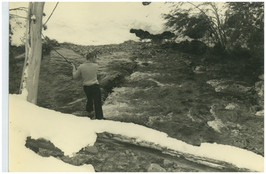 Falls Creek Historical Society
Photograph - Ray Meyer at Blair's Hut
MEYER COLLECTION - FALLS CREEK PHOTOS In 1947 a determined group of like-minded State Electricity Commission (SEC) staff including Ray Meyer, the chief surveyor of the Kiewa Hydro-Electric Scheme, had a common interest that revolved around the skiing potential of the snow-covered high plains which included what is now the resort of Falls Creek. The six SEC employees, Toni St Elmo, Ray Meyer, Jack Minogue, Lloyd Dunn, Adrian Ruffenacht and Dave Gibson (together with their families) banded together to secretly build a 'hut' that was the first ski lodge at Falls Creek. Using a road built in 1930s to gain access to Falls Creek, their hut project was carried out in secret as efforts by other skiers were blocked by H.H.C. Williams – the engineer in charge of the Hydro Scheme. In 1946 Ray Meyer made a trip to the Lands Office in Melbourne. He came away with a 99-year lease on three acres that was ideally suited for a hut designed by Lloyd Dunn. Adrian Ruffenacht (Design Engineer for the KHS) had suggested where the group should build because of easy access to a spring for water. Much of the building material required was scavenged from derelict huts on the high plains. Due to the need for secrecy, the determined group worked on the hut in the evenings and weekends to avoid detection. During the building period the group had met at Echidna Rock (now known as Eagle Rock) where Skippy St Elmo announced, "This is my favourite ‘Skyline’.” And so the first lodge in the area at Falls Creek Ski Resort came into existence. With the development of the International Poma in the 1970s, the Skyline Lodge, which was sited between the ski-lift’s pole one and pole two, was demolished. However, the legacy of Ray Meyer, Toni St Elmo, Jack Minogue, Lloyd Dunn, Adrian Ruffenacht and Dave Gibson and Skyline lives on in the vibrant atmosphere of Falls Creek Resort. The MEYER COLLECTION documents developments on the Kiewa Hydro Scheme and their life at Falls Creek from the mid 1930s to 1960s.This image is significant because it documents the activities of a prominent family in Falls Creek, VictoriaA photo of Ray Meyer at the Kiewa River near Blairs Hut. The original hut, built by cattlemen Frank and Tim Blair in 1923-24, was burnt down around 193o. It was rebuilt by Frank and his son in 1932. It is constructed of Alpine Ash.ray meyer, blairs hut, falls creek, victorian snowfields -
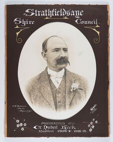 City of Greater Bendigo - Civic Collection
Photograph - Portrait of Councillor Keck, W H Robinson, c 1913
The district of Strathfieldsaye was proclaimed in 1861 and named a Shire on the 17th September in 1866. It remained a shire until amalgamation in 1994 when it became part of the City of Greater Bendigo. The shire was located 8 km to the south- east of Bendigo and covered an area of 601 square kilometres and extended from the Calder Highway to the Coliban and Campaspe Rivers. The shire's administration centre was in Strathfieldsaye until 1972 when new offices were opened in Kennington.Framed black and white head and shoulder portrait of Councillor Keck with hand coloured and drawn detail. Profile slightly to right with walrus moustache. Cut oval brown mount decorated with text and flowers. Hand written title top and lower centre.Strathfieldsaye / Shire Council / W.H. Robinson / Photo / Bendigo / J.H.E Gribbs / Presented by / Cr Herbert Keck / President 1903-4. 1912-13.shire of strathfieldsaye, councillor keck, strathfieldsaye shire council, president of strathfieldsaye shire -
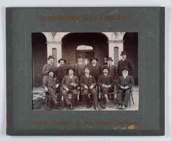 City of Greater Bendigo - Civic Collection
Photograph - Councillor group portrait, W H Robinson, Strathfieldsaye Shire Council, 1909
The district of Strathfieldsaye was proclaimed in 1861 and named a Shire on the 17th September in 1866. It remained a shire until amalgamation in 1994 when it became part of the City of Greater Bendigo. The shire was located 8 km to the south- east of Bendigo and covered an area of 601 square kilometres and extended from the Calder Highway to the Coliban and Campaspe Rivers. The shire's administration centre was in Strathfieldsaye until 1972 when new offices were opened in Kennington.Photographic group portrait of eleven Strathfieldsaye Shire Councillors in front of the Strathfieldsaye Shire Hall. Five men are seated and six standing with one man standing further in back ground on the building's verandah. Photograph is attached directly to green mount card and framed. Gold lettering on mount.Strathfieldsaye Shire Councillors / R. B. Brennan (Sec.) W. J. Lowdes S. Doak M. Burns () N Condon B. Code (Inspector) / WH Robinson Photo Bendigo / T Somerville / W. I. Long / Fred Osborne (President) H Keck / W Dresler / With the President's (Cr. Fred Osborne) Compliments / September 23rd, 1909shire of strathfieldsaye, strathfieldsaye shire council, president of strathfieldsaye shire, strathfieldsaye shire hall -
 City of Greater Bendigo - Civic Collection
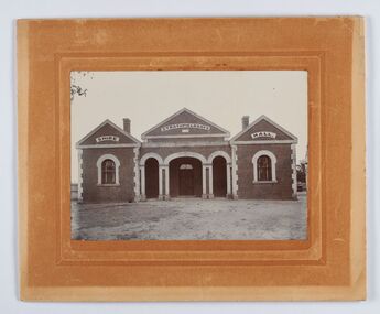
Photograph - Strathfieldsaye Shire Hall
The district of Strathfieldsaye was proclaimed in 1861 and named a Shire on the 17th September in 1866. It remained a shire until amalgamation in 1994 when it became part of the City of Greater Bendigo. The shire was located 8 km to the south- east of Bendigo and covered an area of 601 square kilometres and extended from the Calder Highway to the Coliban and Campaspe Rivers. The shire's administration activities were centred at the Strathfieldsaye Shire Hall which was built in 1869 at a cost of £700 based on a design by George Steane, the shire surveyor and built by George Pallett of Sandhurst. Constructed of red brick, the hall has a unique ventilation system with hollow walls open at the top and bottom to ensure a draught to cool the building in summer. Framed and mounted photograph of the Strathfieldsaye Shire Hall. Verso; W M Robinson / Photographer / Mundy Street Bendigostrathfieldsaye shire hall, shire of strathfieldsaye, strathfieldsaye shire council