Showing 13995 items
matching snowy-river-bridge
-
 Ballarat Heritage Services
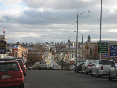
Photograph - Photograph - Colour, Bridge Street Ballarat Looking Towards the West, 2007, 20/07/2007
Colour photograph of Bridge Street Ballarat.bridge street, ballarat, ballarat east -
 Mt Dandenong & District Historical Society Inc.
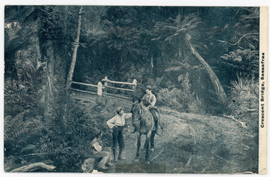
Photograph, Crescent Bridge, Sassafras
The Crescent Bridge in The Crescent at Sassafras. Stories tell us that one of Iris Woolrich’s (nee Dorey) brothers is riding the horse. Photo taken pre WW1.Black and white photograph showing three men, one sitting on a horse, at the Crescent Bridge in SassafrasPrinted on front: Crescent Bridge, Sassafrassassafras, the crescent, woolrich, bridge, track, post card -
 Lakes Entrance Historical Society
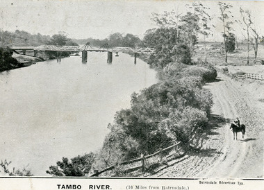
Postcard - Bridges, 1906
First timber road bridge over the Tambo River at Swan Reach officially opened 20 December 1905, after which punt was removed to BairnsdaleBlack and white postcard of the lifting bridge over the Tambo River at Swan Reach, Victoria. Man on horse standing on dirt road to Metung beside the river. Punt previously used to cross river visible against western bank of river.Tambo River (16 miles from Bairnsdale)bridges, waterways -
 Warrnambool and District Historical Society Inc.
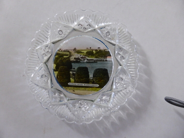
Platter, Transfer Hopkins River
This is a souvenir dish or small plate with an illustration of the Hopkins River in Warrnambool. Included in the illustration are the rowing shed, the boathouses and the lambertiana trees in the property of Lyndoch. The souvenir dish would have been sold to tourists visiting Warrnambool or Warrnambool residents in the 1920s and 30s. This type of souvenir was popular at the time in any tourist town or place in Australia. Tourism has been an important industry in Warrnambool since the late 19th century. This item is of interest as an example of the type of souvenir produced for tourists in the 1920s and 30s. It was both a useful and decorative item. It will be useful for display. This is a small glass souvenir dish. The centre of the dish features a colour illustration of the Hopkins River, Warrnambool (near its mouth). The glass around the illustration is heavily patterned and embossed. The bottom of the dish is dark blue. ‘Hopkins River Warrnambool’ tourism in warrnambool, warrnambool history -
 University of Melbourne, Burnley Campus Archives
Photograph - Sepia Print, 4. View of River Through Fence
Yarra River.Labelled, " View of River through fence."yarra river, mrs. jessep, alexander william jessep, principal, a.w. jessep -
 Kiewa Valley Historical Society
Black and white photograph of Surveyor's Camp, 1938, Kiewa River and surveyor's Camp 25/8/38, 25/08/1938
Surveying under the prevailing conditions at this time was an arduous and demanding task. There were no roads beyond Tawonga and access was by bridle tracks, on foot or horseback. This camp was to provide accommodation to those men who were surveying the road from South Tawonga to the Bogong High Plains which was commenced in April, 1938. The actual work was undertaken by the Country Roads Board, on behalf of the State Electricity Commission, using three Caterpillar diesel crawler tractors equipped with Kay Bruneriei (Brunner) lhydraulically operated trailbuilders (angle dozers)This photograph shows the primitive living conditions that were endured by those carrying out the initial field investigations and surveys for the Kiewa Hydro Electric Scheme. It is possibly one of the few photographs in existence of this camp and of the very rustic timber foot bridge across the West Kiewa river. It has been taken from approx. 100m up Simmonds Creek Road. A black and white photograph showing a small, timber foot bridge across the West Kiewa River. There is a man standing on the bridge and two small huts on the far side of the river, against a backdrop of Mt. Beauty and Mt. Bogong.At the top of the photograph, handwritten in black ink is the inscription "Kiewa River and Surveyor's Camp 25/8/38". The number 4 is stamped towards the right upper corner. On the back, in a circle, about 1.3cm in diameter, are the words "Kodak Print". The word "Velox" is faintly discernible on the back as well.surveyor, tawonga, west kiewa river, bridge, camp, secv -
 Phillip Island and District Historical Society Inc.
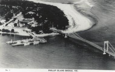
Photograph, Suspension Bridge, 1940
Post Card showing Aerial view of completed Bridge - San Remo 1940. One of the Jack Jenner Collection.Aerial View of Suspension Bridge showing San Remo side. Vessels at pier, middle, left and beach top right.Phillip Island Bridge, Vic. No. 1.local history, photographs, civil engineering, bridges, maritime technology, boats, phillip island bridge, black & white photograph, jack jenner collection, phillip island bridges, public construction -
 Stawell Historical Society Inc
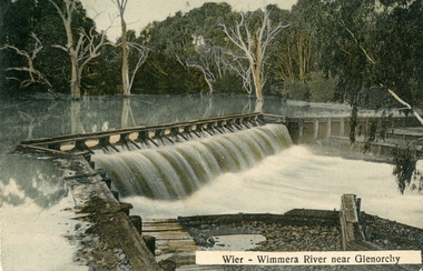
Postcard, Wimmera River Weir at Glenorchy -- Postcard
Wimmera River Weir Glenorchy with letter written on card and 1d stamp.Coloured post card of a weir along a flooded river. Wier-Wimmera River near Glenorchy addressed to Mrs. G. Wood Hill View Stawell. Message from Oliver dated 8/6/10 plus stamp.water -
 Eltham District Historical Society Inc
Photograph, Yarra River from Henley Bridge, Kangaroo Ground, Spring Excursion, Exploring the Upper Yarra, 22 October 1995, 22/10/1995
[article by Bettina Woodburn in EDHS Newsletter No. 105, November 1995:] EXPLORING THE UPPER YARRA - We enjoyed the Spring Excursion, this year "Exploring the Upper Yarra" - in spite of the constant rain and the countryside under the cloud cover, especially in the valleys, being mainly shiny shades of green. The occasional fields of buttercups, clumps of arum lilies and splendid rhododendron and other flowering bushes became very special. The Cobb and Co coach was warm and a cosy retreat as we zig-zagged on the highways and byways to glimpse the Yarra River, upstream and down, its secret places, and particularly the many bridges. Russell excelled as 'Poet Laureate', reading from Dacre Smyth's book. This 1979 publication includes paintings of all the bridges along the river with poems and brief descriptions of each one. Some of the bridges are in out-of-the-way places and are not very well known. We looked forward to hearing the poetry as much as seeing the 'constructions'… Big Pat (was he short or tall, lean or fat? - he did win the £200 reward for discovering gold and had the creek named after him), about the 'Eddies'?, and the disliked 'meccano' bridge in Warburton, etc. etc. The hot roast lunch in the old Reefton Hotel was also most welcome. It was easy to imagine it peopled by miners and early settlers. Starting by crossing the new (1974) concrete bridge at Warrandyte we headed through Wonga Park with views to the Christmas Hills and to the escarpment of the Yering Gorge, which causes flood waters to back up through the Yarra Glen plain, so avoiding disasters downstream. At the end of a long driveway we found the wooden, privately owned Henley Bridge (1935 after the 1934 floods). This facilitates access to different parts of Henley Farm and to Lilydale. Everard Park, named after Blanche Shallard's father, a State Member for 17 years, below the Highway Yarra crossing was in need of care. It is 10 miles from Yarra Glen by road but, as "Yarra Marra” canoeists well know, 32 winding miles down by water. After more delightful countryside scenes we joined the Warburton Highway at Woori Yallock. From the old Railway Station at Launching Place the Centennial Trail for walkers, cyclists and horse riders has replaced the rails. The line from Lilydale was opened in 1901, and the last diesel freight train ran to Warburton in 1965. It continued to rain as we had morning tea in Warburton in a shelter between footbridges. From here we continued upstream past the Bridge to O'Shannassy Lodge and Reservoir, Starvation Creek, and the Peninsular tunnel (miners dug it as at Pound Bend) which we visited (scrambling down those steps!) on our return after lunch. Our furthermost point was the Upper Yarra Dam Reserve (and vast catchment area). Finished in 1957 after ten years' work and 100 years after Yan Yean, it supplies much of Melbourne's water. After crossing the 30m Launching Place Bridge to the Eltham side of the Yarra and Healesville, we saw in the distance the Yarra Glen Timber Trestle Bridge over the river flats "the longest for years in the land it was said!" Harry's dream of "better weather over the Divide" unfortunately didn't come true, but I'm sure we 36 members will retain happy memories of a day that was wet and green and filled with Bridges.Colour photographactivities, upper yarra, henley bridge -
 Ringwood and District Historical Society
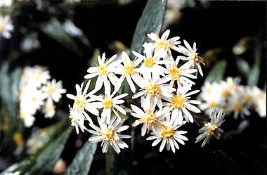
Photograph, Olearia lirata (Snowy Daisy Bush), c. 2000
Common native plant in the Ringwood area.Photograph of Olearia lirata (Snowy Daisy Bush) indigenous to the Ringwood area, Victoria, Australia -
 Lakes Entrance Historical Society
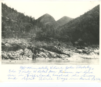
Photograph - Snowy River Buchan, 1977 c
Polish scientist explorer Dr. Lhotsky explored the Australian Alps south of Mt Kosciusko (not named at that date)as far as McKillops Bridge (unnamed then) between 1834 and 1839. His claims were largely ignored he being labelled imposter and humbug but recent research indicates his rightful place amongst Victorias early explorersBlack and white photograph of Snowy River at Suggan Buggan VictoriaApproximately where John Lhotsky the first white man known to have been in Gippsland reached the Snowy and spent three days in March 1834topography, rivers -
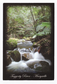 Marysville & District Historical Society
Postcard (item) - Colour postcard, Rosewood Photography, Taggerty River - Marysville, Pre 2009
A colour photograph of the Taggerty River at Marysville in Victoria.A colour photograph of the Taggerty River at Marysville in Victoria. This postcard was produced by Rosewood Photography as a souvenir of Marysville.The Cascading waters of Taggerty River The beautiful & scenic Taggerty River is a 10 minute drive from Marysville, Victoria./ Surrounded by tree ferns & mos covered rocks, the tranquil sounds of the flowing/ river are great place to visit while in Marysville. Photography & Design by/ Roswood Photography/ Mulgrave, Victoria/ [email protected]/ Tel:1300 769 922 Date Stamp 2004/ 6 PM SUNDAY/ Dear Norma & Rod/ All is beauty + peace here/ -the colours are simply/ beautiful every where./ I've done some pleasant/ walking + look forward/ to some more/ Frosty/ mornings perishing - but/ days lovely!!/ Take care - Love-/ Sar-jane A MR + MRS R McDONALD/ 24 PRINCETOWN RD/ MT WAVERLEY/ VIC 3149marysville, taggerty river, victoria, rosewood photography, postcard, souvenir -
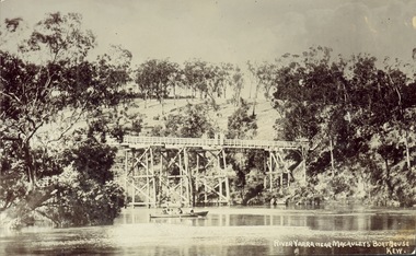 Kew Historical Society Inc
Postcard, J.W.K. & Co, River Yarra near Macauleys' Boathouse Kew, c.1910
The Zig-Zag Bridge which was constructed in the 1870s to link the Yarra Bend Asylum and Kew Asylum. Initially it transported bluestone from the west side of the Yarra to the east during the construction of the Kew Asylum.Real photo postcard of the Zig-Zag Bridge at Kew. In the middle ground there is a rowboat.Obverse: "River Yarra near Macauleys' Boathouse Kew". Reverse: "Gift from L Bennett"bridges -- river yarra, bridges - kew (vic.), zig-zag bridge -
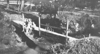 Ringwood and District Historical Society
Photograph, Bridge over Mullum end Adelaide Street, Ringwood. (undated)
Photo taken around 1958-61 of Ed and Imi(Fred) Strauks standing with Brian Burton and brother?, Neil and Mark Clarkson also one other person on the Mullum Mullum Bridge in Ringwood, according to Gaby Strauks.3 children sitting on bridge (unnamed) with tricycle.Written on back of photograph, "Bridge over Mullum end Adelaide Street." -
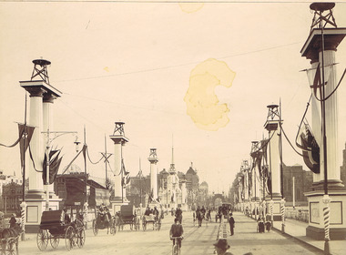 St Kilda Historical Society
Photograph, Frazer, C.J, Princes Bridge, c. 1901
Decorated for the visit of Duke & Duchess of York, 1901 Federation celebrationsblack and white photograph mounted fair conditionPrinces Bridge showing traffic and decorations of flags and bunting -
 Kew Historical Society Inc
Photograph - Former Chandler Highway Bridge, 2001
The heritage listed Fairfield Bridge was originally constructed for the Outer Circle Railway to bridge the Yarra River between East Kew and Fairfield stations. In the 1930s it was converted for vehicular traffic. In the 2010s a new concrete bridge was erected beside it to increase vehicular capacity. Original colour print positive of the (former) Chandler Highway bridge in 2001. The point of view is from the Fairfield side of the river looking towards Kew. The heritage listed bridge was originally constructed for the Outer Circle Railway to bridge the Yarra River between East Kew and Fairfield stations. In the 1930s it was converted for vehicular traffic. In the 2010s a new concrete bridge was erected beside it to increase vehicular capacity. Ink inscription on reverse: "Chandler Highway bridge / (Originally Outer Circle Railway Bridge) / From Fairfield side towards Kew / July 2001"bridges -- kew (vic), fairfield bridge, chandler highway bridge, outer circle railway viaduct -
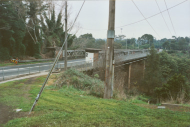
 Eltham District Historical Society Inc
Photograph, Fay Bridge, Fay Bridge at a roadside trader, Heidelberg-Kinglake Road near Cottles Bridge-Strathewan Road, Cottles Bridge, n.d
fay bridge collection, cottles bridge, fay bridge, heidelberg-kinglake road, roadside trader -
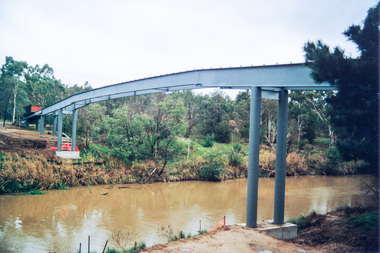 Eltham District Historical Society Inc
Photograph, Doug Orford, Bridge works across Yarra River at rear of Eltham Lower Park, June 2004, 2004
Three colour photographs showing commencement of construction of Eltham-Templestowe footbridge over Yarra River off Homestead Road, Eltham which was completed July 2004.bridges, yarra river, eltham, eltham south, templestowe, eltham lower park, lenister farm, homestead road -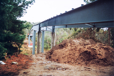
 Eltham District Historical Society Inc
Photograph, Doug Orford, Commencement of bridge works across Yarra River at rear of Eltham Lower Park, May 2004, 2004
Two colour photographs showing commencement of construction of Eltham-Templestowe footbridge over Yarra River off Homestead Road, Eltham which was completed July 2004.bridges, yarra river, eltham, eltham south, templestowe, eltham lower park, lenister farm, homestead road -
 Eltham District Historical Society Inc
Photograph, Doug Orford, Bridge works across Yarra River at rear of Eltham Lower Park, June 2004, 2004
Three colour photographs showing commencement of construction of Eltham-Templestowe footbridge over Yarra River off Homestead Road, Eltham which was completed July 2004.bridges, yarra river, eltham, eltham south, templestowe, eltham lower park, lenister farm, homestead road -
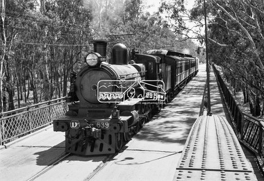 Eltham District Historical Society Inc
Photograph, VR Commissioner's Special train, steam locomotive D3-639 crossing the Echuca-Moama Road Rail Bridge over the Murray River from Moama, NSW to Echuca, Victoria, 1962
VR Commissioner's Special train, steam locomotive D3-639 crossing the Echuca-Moama Road Rail Bridge over the Murray River from Moama, NSW to Echuca, Victoria. Commissioner Edgar Henry Brownbill on footplate, 1962. Commissioner Edgar Henry Brownbill was in office 1957 to 1967. George Coop advises - "The train on the Eltham/Moama bridge is actually the Commissioner’s Special on one of its inspection tours of the VR rail system. This was a very grand special train with accommodation for the Commissioner and staff in carriages also used once for the Royal Train and other State purposes. You can just see the Commissioner of the day, dressed in his suit and wearing engine drivers gloves, standing in the loco cab doorway. A good ‘hands on’ impression is created amongst local staff if can be seen that the boss is no ‘desk jockjey’. The observation car on the back was originally made for the ’Spirit of Progress’. I climbed up onto the bridge iron plate work to get this view. It was safe enough as the cantilevered pedestrian walkway was still on the east side at the time." "I was resident in Echuca from Jan. ’59 to approx. May ’64. At that time the single Echuca/Moama bridge was a combined road/rail bridge. The rail gauge was 5’3” and still is, I believe, on the new bridge that sits just upstream of the old one. This rail line into NSW has always been 5’3" gauge because it has no connection with any NSW tracks. The old Echuca/Moama bridge, locally called the ‘Iron Bridge’ has, over years, undergone some structural changes. The two lattice iron hoops arcing over the roadway have been raised and lowered and changed design. Presently a pedestrian walkway is cantilevered off the west (or downstream) side of the bridge. It used to be on the eastern side. Guess changes went in when new rail bridge only was built on the eastern side as well." Image dated as c.1963 based on same image in Port of Echuca collection (possibly frame 32 of film) (print 19.5 x 24.5cm) On reverse in pencil: "Brown card" in black pen: "Commissioners special. F. Brown on Footplate. George C.L. Coop c1963". https://victoriancollections.net.au/items/59d575b921ea6e1278d78042 However based on frame no. 10, date set as 1962Digital TIFF file Scan of 35mm Ilford FP3 black and white negative transparencyd3-639, d3-class steam locomotive, echuca-moama road rail bridge, edgar henry brownbill, george coop collection, murray river, vr commissioner's special train -
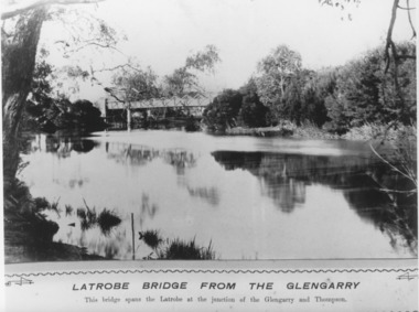 Lakes Entrance Historical Society
Photograph, Caire, Nicholas John, Swing Bridge Sale Victoria c1905, 1905c
Latrobe Bridge from the Glengarry. This bridge spans the Latrobe at the junction of the Glengarry and the Thompson.Black and white photograph of the Latrobe Bridge,in the closed position, taken from the bank of the Glengarry Latrobe River. Sale Victoriawaterways, bridges, civil engineering -
 Ballarat Heritage Services
Photograph - Photograph - Colour, L.J. Gervasoni, Beazley's Bridge Public Hall and Avenue of Honour, 14/08/2011
A number of colour photos of the Beazley's Bridge Hall and avenue of honourbeazley's bridge, beazley's bridge public hall, beazley's bridge avenue of honour, world war one, world war two, world war two, j.j. greenaway, c.w. greenaway, r. peck, j.j.mckay, c.e. long, j.v. mccallum, nurse j. hall, d. mctaggart, j.j. mcgowan, g. mckay, t. mcgowan, h.t. hoskin, a. laing, m. mcquieen, a.w.l. fithall, j.w.a. mcgregor, e. fithall, g. mcivor, r. mclean, j. laing, a.d. mccallum, c. baldwin, c.j. mcrae, m. mccallum, s. mckay, a. mcquieen, f.j. bibby, w.r. bibby, z. brain, j.n. mcdonald, c.h. arbuckle, w.e. fithall, k.p. cifford, t.a. hall -
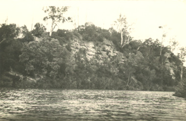 Lakes Entrance Historical Society
Postcard, Tambo River at Tambo Upper Victoria, 1/02/2024 12:00:00 AM
Black and white photograph of the cliffs on the Tambo River at Tambo Upper Victoria. Also two colour photographs of same cliff taken 1999 visit of Monkhouse family 6th to 24th February 1924 on backwaterways -
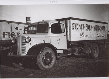 Lakes Entrance Historical Society
Photograph - Fishing Industry Lakes Entrance, Snowy Fanthams truck
Black and white photograph of Snowy Fanthams truck which transported fish Lakes Entrance Victoria. Also one black and white photograph of Snowy Fanthams truck parked beside Mitchelsons house on corner of Barkes Avenue and Lake Street Lakes Entrance on truck Sydney Eden Melbourne Phone Eden 65fishing industry, businesses, vehicles -
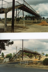 Stawell Historical Society Inc
Photograph, Railway Step Bridge Stawell 1991 -- 4 Photos 2 on one page & 2 Individual Photos
Series of four photos of Railway Step Bridge Stawell 1991Four (4) Colour Photographs, two on one page and 2 individual Photographs.The Two photographs one showing a footbridge in the distance with two cement pipes in front, and a pile of soil further back. A Truck is parked under the bridge. Buildings are in the distance on the lsft side. The Lower photograph is showing the bridge almost dismantled with the surfces of the bridge being held by two cranes with a person on the brdge. The other two photgraphs show the bridge from the groundlooking across the railway tracks one is a clsoe up of the bridge. On the rear of the tow Individual Photographs 224-2a on the top from the left Stawell Old Railway Bridge Bottom left corner ST1-2 224-2b From top left Stawell Old Railway bridge 1991. Bottom left ST1-4stawell, railways -
 Sunshine and District Historical Society Incorporated
Photographs (1928), 'QUARTER MILE' BRIDGE Construction, 1928
One man lost his life during the building of this bridge. The bridge was constructed by the Victorian Railways between 1927 to 1929 to carry a new double track goods line. This enabled trains from all parts of the state except Gippsland to have direct access to the Tottenham marshalling and sorting yards. These yards were constructed in the 1920's to relieve congestion in the Melbourne Yard near Spencer Street station. The congestion was being caused by the construction of suburban passenger platforms associated with the electrification of the suburban railway network. Initially the bridge was for goods trains but during the Second World War it was also used by troop trains. When the standard gauge line was built in 1962 all trains to Albury and Sydney have used this route, thus avoiding travelling through Essendon and Pascoe Vale on the suburban tracks. The standard gauge track across the bridge took the place of one of the broad gauge tracks so broad gauge trains crossing the bridge in either direction have to now use the same track. The bridge is 1,257 feet (383.13 metres) long and 180 feet (54.86 metres) above the water level. It is just 63 feet (19.2 metres) short of a quarter mile in length between abutments. There is a similar bridge on the same railway line crossing the Moonee Ponds Creek between Gowenbrae and Glenroy, however it is smaller at 1060 feet (323.08 metres) length and 115 feet (35.05) height.The bridge is now Victorian Heritage Registered under Number: H1197, and Heritage Overlay Numbers HO5, and HO107. On the Heritage Register it is named RAIL BRIDGE (ALBION VIADUCT). According to the Heritage Report the bridge is scientifically and architecturally important because of its large size, and because of the cost effective design features such as two girders per span (one for each track), the K bracing in the towers, and the broad flange beams as columns. When it was being built it was the largest trestle bridge in Australia, and until the Sydney Harbour bridge was constructed it was the highest railway bridge.Five B&W yellowing photos showing stages of construction of the Maribyrnong River Viaduct known as the Trestle Bridge but mainly known locally as the QUARTER MILE BRIDGE. It is a railway only bridge which runs over the Maribyrnong River between Sunshine North and Keilor East. A sixth image, which is not part of this set of photos, is included to show what the completed bridge looks like. -
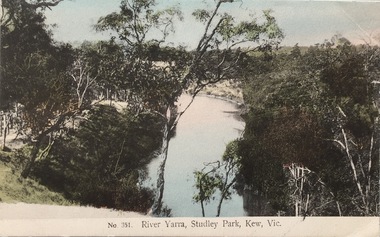 Kew Historical Society Inc
Postcard, The VSM.Series, No.351. River Yarra, Studley Park, Kew, Vic, c.1905
This is a colour postcard of the River Yarra at Studley Park, circa 1905. The postcard, which has handwritten notes on the reverse. It was printed in Prussia as part of the Victoria Stamp Market (VSM) Series. Coloured postcard of the Yarra River looking north from Galatea Point, near the Johnson Street Bridge.Donated by Miss B. Challen. ?Taken from bend above Galatea Point, looking north. Identified by Darcy Dugan, Yarra Bend Parks.river yarra, victoria stamp market (vsm) series, postcards -
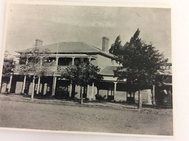 Port of Echuca
A black and white photograph, The Bridge Hotel, in 1896, showing Silky Oak trees, 1970's
The Bridge Hotel was built by Henry Hopwood to house visitors to the town crossing the Murray River on his punt crossing, which was situated just below the Bridge Hotel on the Murray River. The accommodation was spacious and grand! In the right back corner of the photograph, the 'lantern' roof of the St Georges Hall can be seen. The street is level with the front entrance to the Hotel, which is very different to what it is today.The photograph shows hotel activities and accommodation in the late 19th Century.A black and white photograph of the Bridge Hotel taken from the Hopwood Gardens. The photograph shows four silky oak trees growing along the front of the building. There is an empty flag pole outside the front of the building. The right wing advertises billiards, whilst the left wing apparently was a bar.Written on the building can be seen the words; HOTEL and BILLIARDS. Written in pen on the back of the photograph are the words "Bridge Hotel. Probably 1896, showing Silky Oak trees.bridge hotel, henry hopwood, silky oak trees, lantern roof, st georges hotel