Showing 409 items matching "south court"
-
 Ringwood and District Historical Society
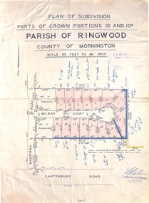
Map - Plan of Subdivision, Parts of Crown Portions 10 and 10B Parish of Ringwood - 1958
Folded subdivision map of 15 residential allotments in McKay Court Ringwood, off Wantirna Road north of Canterbury Road. Rubber stamped by Surveyors and Chartered Engineers J.S. Watson & Associates, Mornington and South Yarra, with illegible signature dated 17/2/58. Handwritten notations indicating allotment sale names and amounts or where passed in.Scale 80 feet to an inch. -
 Bacchus Marsh & District Historical Society
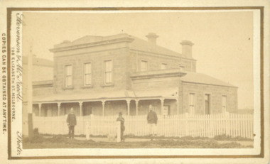
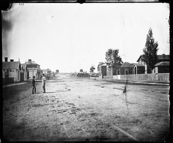
Photograph, Court House Main Street Bacchus Marsh 1883
The Court House in Main Street Bacchus Marsh was built in 1858 using local sandstone. It opened in 1859. It has been used for jury trials, a Court of Petty Sessions, a County Court and a Crown Land sales office. Other uses included an office for the Registrar of Births and Deaths, a Dairy Inspectors office from 1863-1865, and as meeting rooms for the Bacchus Marsh Roads Board, a forerunner of the Shire Council. It was also used by the Bacchus Marsh Shire Council for its offices until at least 1884. In more recent years it has functioned as a Magistrates Court with weekly court sessions. Small sepia unframed photograph on card with gold border framing photograph. Housed in the album, 'Photographs of Bacchus Marsh and District in 1883 by Stevenson and McNicoll'. The view of the Court House building is seen from the northern side of Main Street looking south or south-east. Three men are standing in the street in front of the building. The men on the left and the right wearing police helmets appear to be police officers. The man in the middle is in civilian clothes and might be an officer or employee of the Court House. He has his dog with him. A white picket fence runs along the front of the building. The front courtyard of the building has been renovated since, but this building still operates as a court house.On the front: Stevenson & McNicoll. Photo. 108 Elizabeth St. Melbourne. COPIES CAN BE OBTAINED AT ANY TIME. On the back: LIGHT & TRUTH inscribed on a banner surmounted by a representation of the rising sun. Copies of this Portrait can be had at any time by sending the Name and Post Office Money Order or Stamps for the amount of order to STEVENSON & McNICOLL LATE BENSON & STEVENSON, Photographers. 108 Elizabeth Street, MELBOURNE. stevenson and mcnicoll 1883 photographs of bacchus marsh and district, courthouses, bacchus marsh court house -
 Melbourne Tram Museum
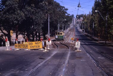
Slide - Set of 3, Keith Kings, 16/03/1968 12:00:00 AM
Set of three 35mm Kodak white cardboard colour slide by Keith Kings of 16 or 17 /3/1968. .1 - W5 834 - on temporary track in Glenferrie Rd during relay looking, south to Kooyong railway station. .2 - photo showing the temporary track and the new 102 lb rail laid out pending welding. .3 - Photo showing W2 418 in Glenferrie Road and trackwork. Route 69" Has the Kooyong Tennis courts on the right hand side. See Keith's slide notes.Keith Kings stamp and number "20-1, 20-2 and 20-3", with details of exposure. .1 - "W5 834 - on temporary track in Glenferrie Rd during relay, south to Kooyong railway station. - 16/3/68" .2 - "Glenferrie Rd relay new 102 lb rail in approximate position in excavation. Ashes rolled as foundation. Temporary track on left. 17/3/68" .3 - temporary track at left being excavated and track drain laid. W2 418 on old track on right. 17/3/68"trams, tramways, glenferrie road, kooyong, trackwork, temporary track, w5 class, w2 class, route 69, tram 834, tram 418 -
 National Vietnam Veterans Museum (NVVM)
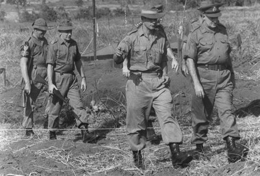
Photograph, Gibbons, Denis, Murder Scene
Denis Gibbons (1937 – 2011) Trained with the Australian Army, before travelling to Vietnam in January 1966, Denis stayed with the 1st Australian Task Force in Nui Dat working as a photographer. For almost five years Gibbons toured with nine Australian infantry battalions, posting compelling war images from within many combat zones before being flown out in late November 1970 after sustaining injuries. The images held within the National Vietnam Veterans Museum make up the Gibbons Collection. A black and white photograph of Members of the Pte Peter A. Allen of 9 RAR Court Marshall Board being escorted by a Military Policeman to the murder scene in the 9th Battalion, Royal Australian Regiment, lines at 1st Australian Task Force Base, Nui Dat, Phuoc Tuy Province, South Vietnamphotograph, pte peter allen, military police, 9 rar, court marshall, nui dat, gibbons collection catalogue, 1st australian task force, 1 atf base, 9th battalion, murdered by soldier, denis gibbons -
 Stawell Historical Society Inc
Photograph, Longfield Street Stawell with buildings on both sides Holtermann Photograph April 1874, by Charles Bayliss of American and Australasian Photograph Co
Part of Holtermann Collection Ref FL1253748.Pleasant Creek Longfield Street Scene looking South. Hotels on left Camp Hotel, Constitution Hotel and Shamrock Hotel on other side of Seaby Street. Pleasant Creek Court House, Shire Hall and Literary Institute on Right. Smith's Store in distance on right, on other side of Seaby Street. Note two wire telegraph poles in distance along side of road beyond Smiths Store. One of the two gentlemen talking is Merlin's photographic assistant Charles Bayliss who toured the Victorian Gold towns producing photographs for American Australasian Photographic Company. From State Library NSW records, Holtermann's Collection. stawell, pleasant creek, hotels -
 City of Kingston
Photograph - Colour, Circa 1993
Edithvale is a suburb in the City of Kingston. It is located between Aspendale and Chelsea on the Port Phillip Bay and built within remnant areas of the Carrum Carrum swamp. The foreshore precinct comprises a wide sandy beach, with low sand dunes and numerous historic boat sheds. The suburb consists of older style dwellings and former holiday houses, combined with mid-century housing and newer homes. The large blocks are increasingly subdivided and the existing dwellings demolished to accommodate units and townhouses, thus changing the landscape of the area and reducing the tree canopy.The beachside suburb of Edithvale was previously part of the extensive Carrum Carrum Swamp. The area was once a source of fish and eels for the Mayone-Bulluk clan of the Bunurong people. Over time the area was drained and predominantly devoted to dairy farming and holiday houses. The farms were gradually sold and subdivided with a large number of homes built after World War II and in the 1960s. Edithvale is mainly residential with a shopping strip along Nepean Highway but little significant industry was ever established in the area apart from a plaster works and confectionary factory, both now closed.Aerial colour photograph of Edithvale as viewed from Alexandra Avenue in the north to Ella Grove Chelsea/Edithvale in the south. The area is built-up with residential housing and facilities including Edithvale Primary School, numerous churches and the Edithvale Railway station. Large sections depict the remnant Carrum Carrum swamp. Edithvale Common and the former "Duck Inn" (Melbourne Water/Friends of Edithvale Seaford Wetlands) can be seen. Edithvale Recreational reserve, the velodrome and Edithvale Public Golf Course are prominent. The image shows vacant land in the area now known as Aspendale Gardens and the newer residential section of Chelsea Heights is not developed. A bike path has been established to cover the secondary drain. The Golf Links Court residential development located off Hughes Avenue is a large vacant block.Yellow circular adhesive sticker on plastic Black ink (marker): * (asterisk) Black type on white adhesive sticker: P000108edithvale, aspendale, chelsea, carrum carrum swamp -
 Bendigo Historical Society Inc.
Document - LONG GULLY HISTORY GROUP COLLECTION: HISTORICAL GUIDE TO BENDIGO
Brochure with an invitation to visit Historical and Mining Museum in Mechanic's Institute, Eaglehawk. Drawing of poppet legs on the front with The Royal Historical Society of Victoria Bendigo Branch. Historical Guide to Bendigo including Self Tours of Bendigo's Famous Goldfields. Forward by John Hattam. Contributors are: H Biggs, Miss L J Parry, A Richardson, L C Bennetts and Edith Checcucci. Credits - The Bendigo Advertiser, Cambridge Press, Mines Department (Bendigo) and J R W Purves. Items include Bendigo Tramways Compiled by H Biggs, Early Bendigo Hotels Compiled by L C Bennetts, Eaglehawk Compiled by H Biggs, Noted Events Compiled by June Parry, The Bendigo Post Office Compiled by LC Bennetts, The Bendigo Goldfield. Introduction to Field and Guide to Some Famous Mines Compiled by A Richardson. Photos include: Pall Mall Bendigo, Ravenswood Homestead, An Early Battery at Kangaroo Flat, Historic High Street Golden Square, The Lonely Grave, Battery Tram c1888, Steam Tram c1892, Electric Tram c1903, The New Chum Railway Golden Square, United Hustlers and Redan Mine Sandhurst Road, Central Deborah Violet Street, Deborah Mine Quarry Hill, Deborah Mine 1000 ft level, First Motion Winding Engine at Central Deborah, Victoria Hill Area, and Looking south from New Chum Hill in 1890's. Also 11010.254, 255, 268, 288a, 288b, and 289.bendigo, history, long gully history group, the long gully history group - historical guide to bendigo, the royal historical society of victoria bendigo branch, historical and mining museum, mechanic's institute eaglehawk, librarian mechanic's institute, miss j parry, john hattam, h biggs, a richardson, l c bennetts, edith checcucci, bendigo advertiser, cambridge press, mines department (bendigo), j r w purves, mr a o'keefe, shire of marong, the sandhurst and eaglehawk tramway company, mr j taylor, mr j hanson, the bendigo tramway company, electric supply company, coliban water suply, juvenile industrial exhibition, geo lansell, cr a harkness, salvation army, vine and fruitgrowers association, decentralisation league, constable thomas ryan, miners association, art gallery, post office, miss broadfoot, bendigo hospital, opera company, bendigo development league, victorian women's franchise league, ana hall, the bendigonian, law courts, temperance hall, trades hall (old wardens court), roman catholic cathedral, shamrock hotel, bendigo philosophical society, old bendigonian society, bendigo fire brigade, bendigo volunteers to south african war, hawkins, porcupine inn, criterion hotel, royal hotel, bendigo hotel, black swan hotel, gillies bakery, hibernian hotel, sandhurst hotel, freemasons hotel, courthouse hotel, shamrock hotel, governor hotham, heffernan & crowley, new chum railway, victoria quartz, shenandoah, shamrock mine, hercules no 1 (originally pearl east), hercules new chum (late pearl), carlisle mine, mr arblaster, meurer, sandhurst bee, benevolent asylum, bendigo gas company, a lloyd, coliban water supply scheme, cr w v simons, eaglehawk council, j mouat, sir henry barkly, agricultural and horticultural exhibition, sandhurst and eaglehawk boroughs, cr john mcintyre, latham and watson's mine, galatea (model ship), st paul's church of england, rev g p despard, fine arts exhibition and exposition, bendigo rifle association, strathfieldsaye shire hall, corporate high school, bendigonian society, richard andrews, easter fair, g aspinall, j burnsides, sir h manners sutton, beehive stores, mining exchanges, bendigo water works, city family hotel, bendigo united friendly society medical institute and dispensary, benevolent asylum, jewish synagogue, masonic hall, school of mines, mr j h abbott, australian natives association, royal princess theatre, albion hall, central state school, high school, gravel hill state school, electricity commission, james mouat, warring natives, the rocks, joseph crook, gold discovery, marong district roads board, camp hotel, mr charles sherratt, city of bendigo, mt alexander north run, grice and heape, ravenswood, gibson and fenton, mrs john kennedy, mrs patrick farrel, mr j a paton, mr lachlan mclachlan, theatre royal, sir charles and lady hotham, harney's bridge, e j ennor, sandhurst fire brigade, the health of towns act, mr townsend, cornish & co, bendigo pottery, bendigo agricultural society, pike or pyke, baby health centre, sandhurst post office, government survey office, sandhurst trustees company, mr h b briston, savings bank, telegraph office, sir henry brougham lock, hon sir john nimmo, sandhurst public offices, the new prince of wales mine, new prince of wales no 2, the whip and jersey, lansell's big 180, new chum and victoria mine and battery, new chum railway, koch's pioneer, south new moon, catherine reef united, new moon, virginia mine, south belle vue, new chum railway, central nell gwynne, north nell gwynne, ironbark mine, new chum syncline, hercules, herculesl energetic, roberts & sons, harkness & co, horwoods, great southern, ulster, carlisle, cornish, new st mungo, duchess tribute, south devonshire, hopewell mine, saxby mine, mcnair & co, mr king, bourke and wills, sandhurst hotel, the dascombe nugget, victoria nugget, r r haverfield, ballerstedt, rae, wittscheibe, lazarus, cave and amos, bendigo amalgamated goldfields, bendigo mines limited, the deborah, north deborah, central deborah, the new red white and blue consolidated (big blue), union, lansell's new red white and blue 9later no 3 shaft), h harkness & co, thompson & co, central deborah, lansell's bendigo battery, north red white and blue, central red white and blue, roberts and sons, little 180 (originally lansell's 180 no 2 shaft), john brown knitwear factory, south ironbark originally victoria consols east shaft, ironbark (originally ironbark east shaft), manchester arms hotel, wattle gully mine chewton, hercules, old wheal-owl, central nell gwynne, gold mines hotel, bendigo city council, jack barker, the new chum syncline, the courier of the mines, telegraph office, bendigo cemetery, white hills cemetery, eaglehawk cemetery, kangaroo flat cemetery, new moon, suffolk united, north new moon, fortuna hustlers, buckell & jeffrey's, royal hustlers reserve no 2 (city and park shafts), jonathan harris, latham and watson, great hustlers, great extended hustlers, j hustler, latham, watson, tribute or pups shaft, bendigo's worst mining disaster, hustlers reef (old hustlers), hustlers reef no 1, lansell's comet, the old comet (cooper's claim), united hustlers and redan, comet hill state school, k k shaft, north or new hustlers (agnew hustler), johnson's no 3, south johnson's, lansell's sandhurst needle, cleopatra needle top, british american, collman and tacchi, south virginia, saddle reefs and spurs, pall mall bendigo, ravenswood homestead, an early battery at kangaroo flat, historic high street golden square, the lonely grave, battery tram c1888, steam tram c1892, electric tram c1903, teh new chum railway golden square, united hustlers and redan mine sandhurst road, central deborah violet street, deborah mine quarry hill, deborah mine 1000 ft level, first motion winding engine at central deborah, victoria hill area, looking south from new chum hill in 1890's -
 Bendigo Historical Society Inc.
Document - LONG GULLY HISTORY GROUP COLLECTION: INCURSION 1/11/1935 TO -/5/1936
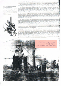
BHS CollectionPhotocopy of a page with photo of the Little 180 Gold Mine N. L. and a C. P. Diamond Drill used in underground prospecting. Article mentions an incursion which took place between 1/11/1935 to -/5/1936 between the Little 180 and Central Blue. It mentions the people involved and the Court judgement that was made. Written on the back is - this was sitting where Spotlight is now.. Junction of Marong Eaglehawk Rd. A pink sticker on the photo has written on it - this was on the spot now known as Spotlight.bendigo, history, long gully history group, the long gully history group - incursion 1/11/1935 to -/5/1936, e g robertson, savage, little 180, james elliot potter, south new chum syncline, h thompson, lou moroni, syd edwards, central blue, new chum syncline, bendigo crushing company, frank savage, h e jones, robert wills, spotlight, m thomson -
Clunes Museum
Painting - PAINTINGS, David Williams
Images of; Horse Trough & Wagon Residence 94 Bailey Street Former Presbytery St. Thomas Aquinas Former Clunes Free Library Residence 25 Camp Street Monument 100 years of gold Clunes in Melb Monument Former butcher's shop Fraser Street Residence & shops 41-43 Fraser Street Clunes School of Mines Clunes War Memorial Residence 32 Leslie St Clunes Former suspension bridge Former St Paul's Vicarage 42 Service Street Former Police Office Former Police residence Portable Lock Up Former Dow Residence 9 Hill St Former Hall & Fire Station 2 Hill St St Paul's timber Church hall St Paul's Church Masonic Lodge 23 Service St St Paul's Pulpit Masonic Lodge interior Everhard cordial bottles Scythes in Clunes Museum Ascot Blacksmith shop Former Ascot hotel MIA Hall Ascot The Coghill Monument Former Methodist Church Coghills Creek Clunes Cemetery Chapel Maiden Hill Homestead shearing shed Beckworth Court stables Beckworth Cour shearer's quarters Former School Evansford Glengower Outbuilding Amerst Former Mortuary 46-50 Fraser Street Wood fired heater Beckworth court farm shed Gold mine trolley Servant's bells Maiden Hill cow bail Former South Clunes school 29 George Street 70 Fraser Street Former Post Office "Allowah" Clunes Street Ascot "Homestead" Beackwith Court "The Meat House" Beckwith Court "Shearing Sheds" Beckwith Court Evansford Community Hall 54 watercolours remaining from the 2003 exhibition held at Clunes, all unframed, depicting Clunes and surrounds architecture and streetscapes.BY DAVID WILLIAMSwatercolour, 2003 exhibition -
 Bendigo Historical Society Inc.
Document - VICTORIA HILL - RECOMMENDATIONS FOR VICTORIA HILL
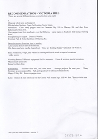
BHS CollectionHandwritten notes on recommendations for cleaning up and signposting Victoria Hill. Also contains list of photos from the Bendigonian of 1899. List of photos: Shamrock Mine, Undershot Water Wheel at Diamond Hill for Phillips Crushing Battery. Mr. Ballerstedt's Crushing Battery at Victoria Hill, Thompson's Foundry at Castlemaine, Machinery made for Bendigo Mines, Air Compressor at Shenandoah Mine, Winding Engine at Koch's Pioneer Mine, Poppet Legs at Koch's Pioneer Mine, Air Compressor at New Chum Railway Mine, Fortune Hustlers G M Co Bendigo View of Mine, Winding Plant and Afternoon Shift and Underground Work in the New Chum Railway. Also mentioned are notes on Machinery made by Thompsons. Also, a carbon copy of Annual Report to Bendigo Branch Royal Historical Society, Victoria 1/7/71. Mentioned in the Report are: Historical Ball, The Central Deborah, Victoria Hill, Tours and Society Business. Albert Richardson document?document, victoria hill, recommendations for victoria hill, north old chum, ballerstedt's rich 24 yard claim, floyds battery lansell's big 180, the bendigonian 26/1/1899, 2/2/1899, 20/4/1899, 11/5/1899, 10/8/1899, 14/9/1899, shamrock mine, undershot waterwheel at diamond hill, phillips crushing battery, mr ballerstedt's crushing battery, thompson's foundry, shenandoah mine, koch's pioneer mine, new chum railway mine, fortuna hustlers g m co bendigo, new chum railway, st mungo lady barkly, catherine reef, new moon, rae's open cut, old court house eaglehawk, police barracks, vic wodetzki, joss house, central deborah, central nell gwynne, mr harold curnow, bendigo branch royal historical society victoria, mrs kingerlee, felicity kingerlee, mr h biggs, city council, rotary club of bendigo south, white hills cemetry, chinese joss house, bendigo pottery, mr derham, reservoir high, princess theatre, a n a hall, mr hattam, col. sprenger, survey corps, a richardson -
 Bendigo Historical Society Inc.
Document - NEW CHUM & VICTORIA LINES OF REEF - THE NEW CHUM REEFS AND SOUTH VICTORIA
Handwritten notes on the New Chum Reefs (White & Black Leads) and South Victoria. Ref. Dicker's 23/11/1861 Pages 7 to 9. Notes include geography, Claims, Owners, Area & Title, Workings, Reef and Yield, Drainage and Remarks. Dates are 13/8/1861, 16/10/1861 and 11/9/1861. Also, a typed copy is includeddocument, gold, new chum & victoria lines of reef, the new chum reefs and south victoria, dicker's 23/11/1861 pages 7 to 9, bonatti's claim, gibbs & lazarus claim, phoenix company, south victoria, the black lead, messrs ballerstedt, garibaldi's company's claim, new chum company, m'dougall, inglis, menzies, dehan, the white lead, new chum quartz mining company, bonati and company, phillip bonati, woolcrow, albrecht, pragleman, mortinson, plumbreck, emmerling, sievis, denis's claim, messrs thompson and powell, geo denis, begelhole and company, mr begelhole, brown, blackwell, hildebrand & co, begelhole & co, w begelhole, thomas brown, henry begelhole, john blackwell, watson & co, j b watson, gibbs, lazarus, local court grant, gibbs & lazarus claim, mr gibbs, mr lazarus, phoenix company's claim, pioneer company, henry jackson, sullivan, burrows, chambers, marshall, william gunther, klemin, fulton, brown, brown, anderson, first quartz mining company, burrow's & co's claim, hudson's, thomas burrows, w philips, george hudson, john wybrant -
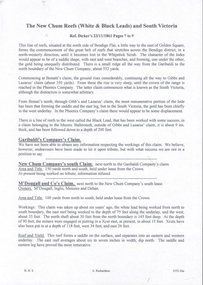
 Bendigo Military Museum
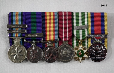
Award - MEDAL SET VIETNAM, MALAYA, Post 1960
The items belonged to Peter James Dodd. Refer Cat No 2436.2P for his service history. Court mounted set of medals re Vietnam and Malaya set on a plastic pocket holder. 1. Australian Active Service Medal 1945 0 75 with clasps “Vietnam & Malaya”. 2. Australian General Service Medal with clasp “Malaya”. 3. Vietnam Campaign Medal. 4. Australian Defence Medal 5. South Vietnam Medal with clasp “1960-“ 6. Pingat Jasa Malaysia Medal. On medals 1 - 4. “217842 P.J.DODD”medals, military, vietnam, malaya -
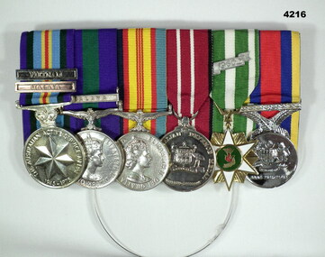
 Bendigo Military Museum
Award - MEDAL SET VIETNAM, Post 2000
This replica set is related to Paul Reidy No 3793403, KIA Vietnam. Refer Cat No 2526.2Set of 5 medals court mounted, all medals are replicas, not engraved. 1. Australian Active Service medal 1945 - 75 with clasp Vietnam. 2. Vietnam Campaign medal. 3. Defence medal. 4. Anniversary of National Service medal. 5. South Vietnamese campaign medal with clasp 1960.award, medal set, vietnam -
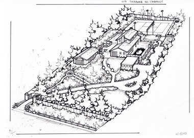 Whitehorse Historical Society Inc.
Artwork, other - Ink Line Drawing, Margaret Picken, 103 Terrara Rd. Vermont, circa 1985-2005
A property illustration by Margaret Picken Commissioned by a real estate agency for the purpose of advertising 103 Terrara Rd. Vermont. This property is listed as having sold in for $400,000 in 1986, and having been sold twice in the interim, sold again in 2004 for $1,080,000. Made by using Rotring ‘Rapidigraph’ drafting pens with Rotring ink on Rapidigraph polyester drafting film, double matte. Trained as a cartographic draftsman within the mining industry, Margaret Picken is an artist who worked producing property illustrations for real estate agencies in eastern suburbs of Victoria from 1983-2005. Retiring from the industry as technological changes favored coloured photography over illustrations, and commissioning companies over sole contractors.This artwork is of Historical Significance as a record of local domestic architecture.A black ink line drawing on drafters film by Margaret Picken, of a birds eye view of a property shown on the diagonal. In the bottom left corner a gated driveway winds toward the upper right, through landscaped gardens. Leading up to a separate multi car garage. There is a sperate annex left of the garage, and the main two story house further back. At the every end of the property is a tennis court.103 Terrara Rd. Vermontwhitehorse historical society, schwerkolt cottage, housing, architecture, margaret picken, house, garden, real estate, vermont, vermont south -
 Kiewa Valley Historical Society
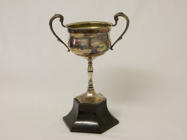
Trophy - Tawonga South Tennis, 1950
The Tawonga South Tennis Club commenced in 1946 and was situated on the last property on the riverside before the Tawonga South bridge where there was also a kiosk. Tennis was very popular in the Kiewa Valley with the influx of players available from the Kiewa Hydro Electric Scheme. In the Bogong-Tawonga Tennis Association there were three Bogong teams - Cope, McKay and Beauty with the other teams from Tawonga called Wanderers, Rovers, Pines and South Tawonga. Reported in the SEC magazine, Oct--Nov. 1946 Page 45:- "The membership now totals eighty, and both Bogong courts are in continuous use during week-ends and in the evenings and early mornings." There were clubs & teams in Bogong, Mt Beauty and Tawonga. This trophy indicates that there was a tennis association at Tawonga South in 1950. In 1945 the Tawonga South school was set up to serve the children of the State Electricity Commission of Victoria employees. The school was extended from one room to two in 1955 to avoid congestion. This would indicate that the population would have been sufficient for a tennis club as well. In the SEC Magazine 1946 Page 45:- "South Tawonga Tennis Club has arranged social functions to raise funds, and working bees are busy on the erection of a tennis court. The president is Mr. N. Piera, the secretary Mr. H. Wilson and the treasurer Mrs. W. Griffiths.Tarnished metal trophy with cup and two, extending above the cup, handles either side. The cup is raised by a decorated stem which is attached to a brown plastic hexagonal base. Tawonga South Tennis / Association 1950 / Donated by G.T.Kennedytennis. tawonga south. g.t. kennedy. kiewa valley. sport. club -
 Buninyong & District Historical Society
Photograph - Photograph of Old Court House from the south, Old Court House Buninyong
... Photograph of Old Court House from the south... Court House from the south ...Photogragh of Old Court House Buninyongold court house, buildings. -
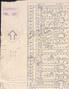 Ringwood and District Historical Society
Map, Subdivision Plan of 141 allotments off Jarma Road, Heathmont, Victoria - Circa 1957
Folded subdivision map on cardboard backing with real estate sales notations on some allotments. Subdivision includes Jarma Road, Reilly Street, Adrian Court, Valerie Court, Daisy Street, Joel Court, Ross Court, and Canterbury Road, Heathmont.Rubber stamp imprint in top left corner - J.S. Watson & Associates, Surveyors & Chartered Engineers, 7 Main Street Mornington, Phone Mornington 2186 & 24 Kensington Road, South Yarra, Phone BJ2155. -
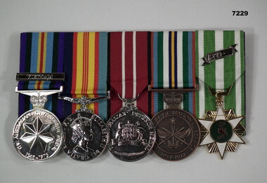
 Bendigo Military Museum
Award - MEDAL SET VIETNAM, MALAYA, Post 1975
The miniatures belonged to Peter James Dodd, refer Cat No 2436.2P for his service details.Miniature medal set Court Mounted. 1. Australian Active Service Medal 1945 - 75 with clasps “Vietnam & Malaya” 2. General Service Medal with clasp “Malaya”. 3.Vietnam Campaign Medal. 4. Australian Defence Medal. 5. South Vietnamese medal with clasp “1960-“. 6. Pingat Jasa Malaysia Medal.“217842 P.J.DODD”awards, medals, vietnam, malaya -
 Bendigo Historical Society Inc.
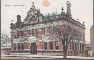
Postcard - Australia, Elliot Collection, 1895 - 1914
Thought to have originated in Austria in 1869, postcards first gained popularity in Australia in the 1890s.They were used to send short messages to friends and family. This collection was generated by Mrs James Elliot of Talgarno. Talgarno is a rural locality in Victoria, Australia, situated on the southern shoreline of Lake Hume, about 23 km east of Albury-Wodonga. The collection contains postcards from across the world.Australian postcards collected by Mrs. James Elliot between 1898 and 1915. 1405.061 Mechanic's Institute, Albury 1405.062 Kiama, N.S.W. 1405.063 Dean Street, Albury, N.S.W. 1405.064 Union Bank and Post Office, Temora 1405.065 Middle Harbour, Sydney 1405.066 Sydney University, Sydney 1405.067 Botanic Gardens, Sydney 1405.068 Bridge Street, Sydney 1405.069 Botanic Gardens, Sydney 1405.070 the Two Bridges, Yass 1405.071 Court house, Yass 1405.072 Church of St. Augustine, Yass 1405.073 The Grotto, Church of St. Augustine, Yass 1405.074 Hume and Hovell Monument 1405.075 Flat Rock, Middle Harbour, Sydney 1405.076 the Dam, National Park, New South Wales 1405.077 Hamilton Hume's Monument, Albury Gardens 1405.078 the weir, Yass 1405.079 Lane Cove River, Sydney, N.S.W. 1405.080 Suspension Bridge, North Sydneypostcards, collecting, collections, talgarno