Showing 285032 items matching "streets,roads,melbourne,map,melway"
-
 Bendigo Military Museum
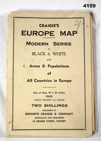
Map - MAP of EUROPE, Craigie"s Europe Map, 1939
The map features the areas and populations of all European countries as per 1939. Part of the collection re Frederick Gardner Davey DFC No 410533 RAAF. Refer Cat No 3536P for his service details.Folded map in black and white. Coloured British and German flags are pinned to countries on the map.On the front cover in pencil, “2/-“. (2 schillings)maps, europe -
 Kew Historical Society Inc
Plan, Melbourne & Metropolitan Board of Works : Borough of Kew : Detail Plan No.1588, 1904
The Melbourne and Metropolitan Board of Works (MMBW) plans were produced from the 1890s to the 1950s. They were crucial to the design and development of Melbourne's sewerage and drainage system. The plans, at a scale of 40 feet to 1 inch (1:480), provide a detailed historical record of Melbourne streetscapes and environmental features. Each plan covers one or two street blocks (roughly six streets), showing details of buildings, including garden layouts and ownership boundaries, and features such as laneways, drains, bridges, parks, municipal boundaries and other prominent landmarks as they existed at the time each plan was produced. (Source: State Library of Victoria)This plan forms part of a large group of MMBW plans and maps that was donated to the Society by the Mr Poulter, City Engineer of the City of Kew in 1989. Within this collection, thirty-five hand-coloured plans, backed with linen, are of statewide significance as they include annotations that provide details of construction materials used in buildings in the first decade of the 20th century as well as additional information about land ownership and usage. The copies in the Public Record Office Victoria and the State Library of Victoria are monochrome versions which do not denote building materials so that the maps in this collection are invaluable and unique tools for researchers and heritage consultants. A number of the plans are not held in the collection of the State Library of Victoria so they have the additional attribute of rarity.Original survey plan, issued by the MMBW to a contractor with responsibility for constructing sewers in the area identified on the plan within the Borough of Kew. The plan was at some stage hand-coloured, possibly by the contractor, but more likely by officers working in the Engineering Department of the Borough and later Town, then City of Kew. The hand-coloured sections of buildings on the plan were used to denote masonry or brick constructions (pink), weatherboard constructions (yellow), and public buildings (grey). This plan shows the original configuration of the Kew Post Office, Court House and Police Station, which had opened in 1888. This configuration was to essentially remain until the purchase of the Court House and Police Station by the City of Boroondara in 2007 and its subsequent renovation. Interestingly, the MMBW surveyors incorrectly labelled parts of the complex. In the triangle in front of the Post Office, before the erection of the Kew Cenotaph in 1925, was located a lawn and the Queen Victoria Jubilee Fountain. While many of the shops on the south side of High street had been constructed by 1903 a number of sites were still used as vegetable gardens. Further along High Street, on the corner of Charles Street, the Salvation Army Barracks can be seen on the plan. These Barracks predate the later Citadel and ‘Young People’s Hall’ that were opened in 1919. At 22 Charles Street can be seen the house of James Venn Morgan. Hailed as the ‘father of Kew’, Morgan arrived in Melbourne in 1840. He was first engaged as a bookmaker, but a fortunate venture on the goldfields enabled him to purchase land in Kew. He conducted a market garden and dairy in Kew for many years.melbourne and metropolitan board of works, detail plans, maps - borough of kew, mmbw 1588, cartography -
 Ringwood and District Historical Society
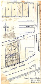
Map, Partially trimmed copy of a retail and residential auction advertisement, Ringwood, Vic. - 1926
One of 3 unrelated land subdivision maps on cardboard backing. Numbered allotments on Nelson Street, Seymour Street and Whitehorse Road, Ringwood.W.J. Bonwick, Licensed Surveyor, Phone WU4830. Location map also includes Bourke Street, Bond Street, Charter Street, Ringwood Street, and Shops and Market sites in Ringwood. -
 Kew Historical Society Inc
Plan, Melbourne & Metropolitan Board of Works : Borough of Kew : Detail Plan No.1581, 1904
The Melbourne and Metropolitan Board of Works (MMBW) plans were produced from the 1890s to the 1950s. They were crucial to the design and development of Melbourne's sewerage and drainage system. The plans, at a scale of 40 feet to 1 inch (1:480), provide a detailed historical record of Melbourne streetscapes and environmental features. Each plan covers one or two street blocks (roughly six streets), showing details of buildings, including garden layouts and ownership boundaries, and features such as laneways, drains, bridges, parks, municipal boundaries and other prominent landmarks as they existed at the time each plan was produced. (Source: State Library of Victoria)This plan forms part of a large group of MMBW plans and maps that was donated to the Society by the Mr Poulter, City Engineer of the City of Kew in 1989. Within this collection, thirty-five hand-coloured plans, backed with linen, are of statewide significance as they include annotations that provide details of construction materials used in buildings in the first decade of the 20th century as well as additional information about land ownership and usage. The copies in the Public Record Office Victoria and the State Library of Victoria are monochrome versions which do not denote building materials so that the maps in this collection are invaluable and unique tools for researchers and heritage consultants. A number of the plans are not held in the collection of the State Library of Victoria so they have the additional attribute of rarity.Original survey plan, issued by the MMBW to a contractor with responsibility for constructing sewers in the area identified on the plan within the Borough of Kew. The plan was at some stage hand-coloured, possibly by the contractor, but more likely by officers working in the Engineering Department of the Borough and later Town, then City of Kew. The hand-coloured sections of buildings on the plan were used to denote masonry or brick constructions (pink), weatherboard constructions (yellow), and public buildings (grey). The streets and built structures in this plan were surveyed in 1903 and released to contractors in 1904. In addition to the designation of building types by colour, the plan includes detailed descriptions of land use and ownership. While many buildings remain from this period, a number of the buildings represented have been demolished including the original Kew Town Hall, and the Congregational and Roman Catholic churches in Walpole Street. While the mansion ‘Illapa’ in Princess Street is still extant – now part of ‘Rylands’ – the neighbouring mansion ‘Elsmere’ was demolished some decades ago. Rivalling Illapa and Elsmere in size were two mansions in Walpole Street, one named on the plan as ‘Gnarlbine’. Over time, Kew Junction and the south side of High Street have been reconfigured and widened, so that the commercial buildings on the corner of Princess and High Street no longer exist. A surprising feature of this part of central Kew to the northwest of Kew Junction is the amount of vacant land. In a number of cases, this land is noted by the contractor as used for vegetable gardens.melbourne and metropolitan board of works, detail plans, maps - borough of kew, mmbw 1581, cartography -
 Bacchus Marsh & District Historical Society
Map, Parwan Parish Map, County of Grant, 1909
A single page paper map showing the map for the Parish of Parwan in the County of Grant. A cadastral map showing parish boundaries and land ownership. The map is pasted into a bound volume containing 76 maps or plans in total. High resolution digital image stored on BMDHS computer network. Photo-lithographed at the Department of Lands and Survey, Melbourne by T.F. McGauran, 7.7.09. bacchus marsh region parish plans, parwan parish maps, parwan parish plan -
 Bacchus Marsh & District Historical Society
Map, Blackwood Parish Map, County of Bourke, 1892
A single page paper map showing the map for the Parish of Blackwood in the County of Bourke. A cadastral map showing parish boundaries and land ownership. The map is pasted into a bound volume containing 76 maps or plans in total. High resolution digital image stored on BMDHS computer network. Photo-lithographed at the Department of Lands and Survey, Melbourne by T.F. McGauran 14.7.92bacchus marsh region parish plans, blackwood parish plan, blackwood parish maps -
 Bacchus Marsh & District Historical Society
Map, Blackwood Parish Map, County of Bourke, 1905
A single page paper map showing the map for the Parish of Blackwood in the County of Bourke. A cadastral map showing parish boundaries and land ownership. The map is pasted into a bound volume containing 76 maps or plans in total. High resolution digital image stored on BMDHS computer network. Photo-lithographed at the Department of Lands and Survey, Melbourne by T.F. McGauran 21.7.05bacchus marsh region parish plans, blackwood parish plan, blackwood parish maps -
 Bacchus Marsh & District Historical Society
Map, Myrniong Parish Map, County of Bourke, 1882
A single page paper map showing the map for the Parish of Myrniong in the County of Bourke. A cadastral map showing parish boundaries and land ownership. The map is pasted into a bound volume containing 76 maps or plans in total. High resolution digital image stored on BMDHS computer network. Photo-lithographed at the Department of Lands and Survey, Melbourne by J. Noone, 17.7.82myrniong parish plan, myrniong parish maps, bacchus marsh region parish plans -
 Vision Australia
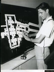
Photograph - Image, Ron Goodwin reading a map of Wynyard train station, 1969?
Ron Goodwin reads a tactile map of Wynyard Railway Station in Sydney's CBD. The map was made at the Sydney Tesol College with wood working machinery and painting/decorating sections. In front of Ron sits a ultrasonic torch.B/W photograph of man looking at relief map of Wynyard Station14/69051 Ann. Report Orientation - historicalroyal blind society of nsw, ron goodwin, maps -
 Greensborough Historical Society
Map, Melbourne and Metropolitan Board of Works. Survey Division, MMBW, Yarra 2500 / 12.23. Janefield and Kangaroo Point, 1977_10
Melbourne and Metropolitan Board of Works. Yarra 2500 [base map] 12-23, Municipalities of Whittlesea 239 and Diamond Valley 257. No streets marked on this map. Includes Plenty River, Kangaroo Point, Janefield Colony and Janefield Reserve.MMBW Map in 1:2500 [scale] series. Cream parchment with green tape reinforcing on edges and punched holes on left edge.mmbw, melbourne and metropolitan board of works, shire of diamond valley, plenty - maps -
 Greensborough Historical Society
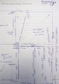
Map - Digital Image, Eric Barclay's Grace Park map, November 2016, 2016_11
Eric Barclay's Grace Park map, November 2016. Eric recalls the area around Grace Park from the late 1940s.Digital copy of black and white maperic barclay, barclay family, grace park -
 Friends of St Brigids Association
Book - Melbourne and the Irish Famine: The unveiling of a new monument, Noone, Val. 1998. Melbourne and the Irish Famine: The unveiling of a new monument. Melbourne : Irish Famine Commemoration Committee, 1998 22 p. : ill., map ; 21 cm
-
 Montmorency–Eltham RSL Sub Branch
Map - Framed 1915 map of Sulva Bay, Gallipoli, 1915 Map of Silva Bay, Gallipoli, 1915
This map was used in the Dardenelles Campaign 1915-1916.Framed map showing the Sulva Bay area of the Gallipoli battlefield in 1915.world war one, middle east, gallipoli, 1915, map, dardenelles, sulva bay, survey department, battlefields, egypt cairo -
 Bacchus Marsh & District Historical Society
Map, Trentham Parish Map 1905 Copy 1
A single page paper map showing the map for the Parish of Trentham in the Counties of Dalhousie and Bourke. A cadastral map showing parish boundaries and land ownership. The map is pasted into a bound volume containing 76 maps or plans in total. High resolution digital image stored on BMDHS computer network. Photo-lithographed at the Department of Lands and Survey, Melbourne by T.F. McGauran 22.3.05 trentham parish maps, trentham parish plan, bacchus marsh region parish plans -
 Bacchus Marsh & District Historical Society
Map, Mooradoranook Parish Map, County of Grant
A single page paper map showing the map for the Parish of Mooradanook in the County of Grant. Cadastral map showing land ownership. The map is pasted into a bound volume containing 76 maps or plans in total. High resolution digital image stored on BMDHS computer network. Photo lithographed at the Department of Lands and Survey Melbourne by T. F. McGauran, 27.11.06mooradoranook parish maps, mooradoranook parish plan, bacchus marsh region parish plans -
Port Melbourne Historical & Preservation Society
Map - Chart, Port of Melbourne Authority, Port of Melbourne, 1994
Used in the library of The Polly Woodside Museum before closure1994 Chart of Port of Melbourne with updated annotations by Glen Stuart between 1994 and 2005port of melbourne authority, piers and wharves, melbourne harbor trust - port of melbourne authority, glen stuart -
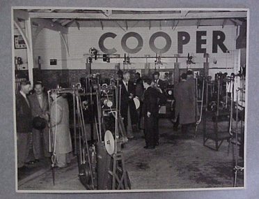 National Wool Museum
Photograph, Display Cooper shearing gear and engines Royal Melbourne Show circa 1951
Photograph of Cooper sheaing machinery display at the Royal Melbourne Show, c1951.Photograph of Cooper sheaing machinery display at the Royal Melbourne Show, c1951.Wolfgang Sievers Photography 9 Collins Street Melbourne C.I. Display Cooper shearing gear and engines Royal Melbourne Show circa 1951shearing machinery, cooper engineering company pty ltd wolfgang sievers photography -
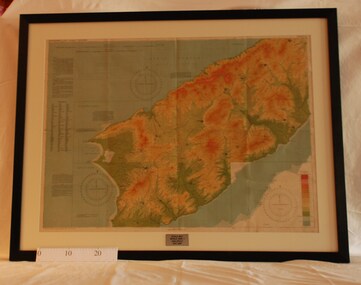
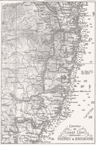 Queenscliffe Maritime Museum
Map - B & W coastal map between Sydney & Brisbane, Australia, Coastal map, Queensland, between Whitsunday Island & Hervey Bay, Before donation in 1987
Australian coastal mapsAustralian coastal mapsCoastal 'soundings' map between Sydney & Brisbane, from an unknown book, pre-1987.Reverse " NIL "old maps of australian coast -
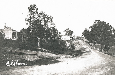 Eltham District Historical Society Inc
Photograph, Eltham (between Henry and York Streets), 1900s
... Eltham (between Henry and York Streets) ...Photocopy of an original image of Main Road, Eltham, south from Henry Street, early 1900s.main road, henry street, eltham -
Lakes Entrance Historical Society
Financial record - Ledger, Country Roads Board Wages Ledger, 1953
... Country Roads Board Wages Ledger ...A Ledger of Wages paid to Country Roads Board employees of East Gippsland VictoriaA Ledger of Wages paid to Country Roads Board employees of East Gippsland Victoriaaccounts book -
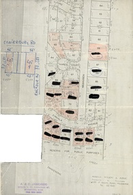
 Kew Historical Society Inc
Plan - Subdivision Plan, J R Mathers & McMillan, Normanby Estate, c.1913
The Kew Historical Society's map collection includes a substantial number of real estate subdivision plans, mainly of Kew but also of surrounding suburbs in Melbourne. Most of the subdivision plans date from the 1920s and 1930s when the districts old homes and local farmland were being split up to accommodate residential growth in the postwar period. These early plans were assembled by a local firm, Jas R Mather & McMillan, which had an office in Cotham Road. Many of the plans, and sometimes photos, were annotated by the agents.Subdivision plans are historically important documents used as evidence for the growth of suburbs in Australia. They frequently provide information about when the land was sold as well as evidence relating to surveyors and real estate and financial agents. The numerous subdivision plans in the Kew Historical Society's collection represent working documents, ranging from the initial sketches made in planning a subdivision to printed plans on which auctioneers or agents listed the prices for which individual lots were sold. In a number of cases, the reverse of a subdivision plan in the collection includes a photograph of a house that was also for sale by the agent. These photographs provide significant heritage information relating house design and decoration, fencing and household gardens.The photograph may also be aesthetically significant depending on the importance of the photographic atelier.The Normanby Estate, which was adjacent to Normanby Road, Kew East, included thirty-one lots for sale. Streets on the subdivision plan include Adeney Avenue, Park Hill Road, Normanby Road, Weir Street and Wharton Street. Cotham Road and its tramway are shown nearby. The plan is interesting as it shows Wharton Street, named after the architect and town planner George Wharton, who was the first chairman of the Municipality of Kew. The street was to later be renamed Cecil Street. Also shown are proposed ‘Municipal Gardens’ where Parkhill Drive is now located."D" in top left corner. Stamped auctioneers contact details: "Jas. R. Mathers & Son & McMillan / Auctioneer & Land Salesmen, / 271 Collins Street / Melbourne" and Jas. R. Mathers / Estate & Financial Agent / Cotham Road / Kew".weir street - kew, wharton street - kew, normanby road - kew, cotham road - kew, municipal gardens - kew, park hill parkhill road - kew, braemar - kew, subdivision plans - kew -
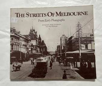 City of Moorabbin Historical Society (Operating the Box Cottage Museum)
Book, Murray. Joe, The streets of Melbourne from early photographs /, 1985
... The streets of Melbourne from early photographs / ...[126] p. : chiefly ill. non-fictionmelbourne, photographs -
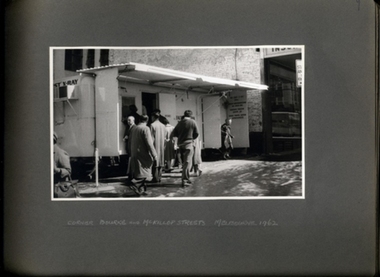 Department of Health and Human Services
Photograph, Anti Tuberculosis Campaign - People queuing and exiting X-ray caravan on a wet day on the Corner of Bourke & McKillop Streets Melbourne 1962 - Department of Health - Tuberculosis Branch - Chest X-Ray Surveys program
... Streets Melbourne 1962 - Department of Health - Tuberculosis ...Photo from Accession AS/14/612 -
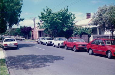 Department of Health and Human Services
Photograph, Cars parked in suburban streets - City Landscapes - Photo taken by Property Management Services / Public housing - Inner City Melbourne - Early 1980s
... Cars parked in suburban streets - City Landscapes - Photo ...Colour Photo taken from slide -
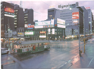 Melbourne Tram Museum
Postcard, Bartel Collectors World, "Melbourne Flinders and Swanston Streets", late 1970s
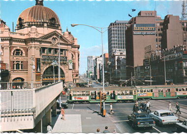
... "Melbourne Flinders and Swanston Streets" ...Photo taken from the Flinders Gate Plaza looking northwest at the intersection of Swanston and Flinders St. Shows the SEC building, Young and Jacksons with many illuminated advertisements such as HBA, Peter Stuyvesant, Coca-Cola, McDonald's, SEC. Photo taken at dusk with W2 574 (City Route 5) northbound - a very empty tramcar - has adverts for Crest Beer and Scope.Yields information about the intersection of Flinders and Swanston Streets.Colour postcard by W Bartel of Sydney - No. M306postcards, swanston st, w2 class, flinders st, tram 574 -
 Melbourne Tram Museum
Postcard, Nucolorvue Publishing, "Melbourne The busy intersection of Swanston and Flinders Streets", late 1960s
... Streets" ...Photo taken from the Flinders Gate Plaza looking west with the edge of the plaza podium fence in the view. In the view are Flinders St station, the SEC building and Young & Jacksons, which has an advertisement for Taubmans Paints. Two trams are crossing Flinders St, a wide-body tram with no marker lights, and W2 302. Based on the tram not being fitted with marker lights and the opening of the Plaza, photo late 1960s. Yields information about the intersection of Flinders and Swanston Streets.Colour postcard by Nu-Color-Vue No. ML 120, with serrated edges.postcards, swanston st, w2 class, flinders st, tram 302 -
 Linton and District Historical Society Inc
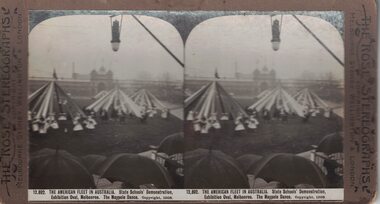
Stereograph, The Rose Stereographs, Melbourne, Sydney, Wellington and London, 12,892 The American Fleet in Australia, State Schools' Demonstration, Exhibition Oval, Melbourne, The Maypole Dance, Copyright 1908
One of two sets of stereographs donated by the O'Beirne family along with a stereoscope for viewing (Stereoscope is Registration no. 2014-51).Groups of school children dancing around maypoles in front of Royal Exhibition Building, Melbourne. Spectators sheltering under umbrellas."12,892. THE AMERICAN FLEET IN AUSTRALIA. State Schools' Demonstration, / Exhibition Oval, Melbourne. The Maypole Dance."stereographs, american fleet -
 Melbourne Tram Museum
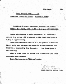
Document - Memorandum, Melbourne & Metropolitan Tramways Board (MMTB), Procession of RAN personnel through city streets, Friday 31 March, 1944, 27/03/1944 12:00:00 AM
... Procession of RAN personnel through city streets, Friday 31 ...Parade of RAN personnel through city streets Friday 31 March 1944 - 1:20PM to 1:55PM Memos from JM Harry, Dist Traffic Supt SS regarding tram arrangements to Inspectors Irvine & MacRae, Glenhuntly, Snr Insp Whitelaw, Hawthorn Depot, Snr Insp Oprey, Snr Insp Brown, Malvern Depot, Insp Hicks, Insp Sumpton, Insp Taylor, Snr Inps Conkey & Parkinson, Mr Fischer. Memo dated 27 March 1944 2 copies of letter from HS Wootton, Town Clerk, to M&MTB regarding arrangements for march. Memo from Assistant Manager to Officers Concerned.Notations written in pencil on several memos.trams, tramways, events, glenhuntly tram depot -
 Camberwell Historical Society
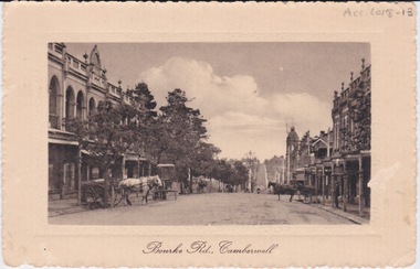
Postcard - Photo postcard, Postcard of Bourke Road, Camberwell, Unknown date but postcard probably dated circa 1900 - definitely pre 1913 because in that year gas lamps were removed from main roads, intersections, also street trees in Burke Road. Also no cars are visible on the street, only horses and carriages. In March 1894 the first streets in the central city of Melbourne were lit with electricity
... main roads, intersections, also street trees in Burke Road ...Undated photograph on postcard depicting horses and carts with gas lamp in the distance on Bourke Road, Camberwell. Front of postcard: 'Bourke Road, Camberwell' Back of postcard: 'Post Card' 'This side for correspondence' 'This side for address' 'Stamp here' 'Printed in Germany.' Handwritten notes '22649 $20'camberwell, bourke road -
 Ringwood and District Historical Society
Document, Map showing numbered subdivision allotments with hand-written notations and redactions - 1924
Foolscap size page Map by Arnold Wilson & Associates, Engineers & Surveyors, 399 St.Kilda Road, Melbourne, Tel 26-1840 - 1924/4. Subdivision includes Ilford Road, Karen Court, Washusen Road and Dirkala Avenue, Heathmont. Also includes hand-drawn allotments on Canterbury Road and Balfour Avenue. Page rubber-stamped by building company A & C Jaworski, Office 2, 23 Ringwood Street, Ringwood 3134, Tel 870-0820, A.H. 870-2062.