Showing 4084 items matching "surveying-terrestrial"
-
 Bendigo Military Museum
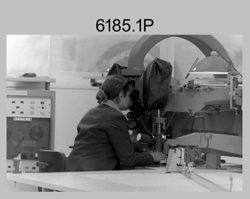
Photograph - Johnson Ground Elevation Meter (JGEM) Survey Vehicle - Army Survey Regiment, Fortuna, Bendigo, c1960s
... surveying ...This is a set of 16 photograph of the Royal Australian Survey Corps’ Johnson Ground Elevation Meter (JGEM) Survey Vehicle taken at the Army Survey Regiment, Fortuna, Bendigo. The JGEM vehicle was extensively used by RA Svy within Australia from the late 1960s. A limited number of Ground Elevation Meter (GEM) station wagon type vehicles were manufactured by General Motors Corporation (GMC) in the USA for the United States Geological Survey, Canada’s mapping agencies, RA Svy and National Mapping (Natmap). The GEM was a four-wheel drive, four-wheel steer vehicle. Four-wheel steering was necessary to avoid systematic errors caused by non-tracking of front and rear wheels on conventionally steered vehicles. The manufacturer substituted the rear axle with a front axle and connected them to form the four-wheel steering mechanism. The two Australian GEM vehicles, referred to as Johnson GEMs (JGEMs) were converted into right-hand drive. After delivery in 1964, acceptance Natmap and RA Svy testing and operator training was undertaken at the Army's School of Military Survey located at Balcombe, Victoria. A small fifth wheel was mounted on a cantilever arm suspension midway between the front and rear wheels on the right side of the vehicle. It was lowered to and raised from its operating position by use of a constant pressure air cylinder. A telescopic bar, suspended between the front and rear axles, provided the reference datum for the angle measurement. The wheel provided the velocity or distance signal through a pulse generator system. A sensitive pendulum mounted on this bar provided the angle measurement for each minute distance traversed. The JGEM contained electromechanical instruments used to determine relative elevations, by trigonometric principles, along a traversed path. These relative elevations were obtained through apparatus which measures the instantaneous angle of inclination of the road and the instantaneous velocity of the meter along such a path. Road routes over which the JGEM operated were planned so that each started and ended as near as practicable to an existing point of known elevation (formally referred to as a level traverse bench mark). The difference in height from the bench mark and the road surface alongside the JGEM’s fifth wheel was measured with a level and staff. Along each route, mapping control photo reference points where new elevation values were required were identified on aerial photographs. Under favourable conditions it was possible to survey as much as 160km in an ordinary working day. The first of RA Svy’s JGEM operations was undertaken in 1:250,000 scale map areas of Queensland. CPL John Hook was the JGEM’s main operator in the early 1970s undertaking operations covering 1:250,000 scale map blocks over northern Victoria and central NSW, each requiring 36 points (9 runs of photography and 4 points across. SPR Lyn Thompson and SPR Bob McDonagh teamed with CPL Hook on some of these JGEM operations. When RA Svy was integrated into the Royal Australian Engineers in 1996, the JGEM vehicle with the Survey Corps collection was donated to its museum. It is believed to be the last of the original manufactured fleet in existence. The JGEM has undergone extensive refurbishment to achieve roadworthiness and is currently housed at The Australian Army Museum of Military Engineering, Hoslworthy Barracks, NSW. It can be viewed by making an appointment with the museum’s curator.This is a set of 16 photograph of the Royal Australian Survey Corps’ Johnson Ground Elevation Meter (JGEM) Survey Vehicle taken at the Army Survey Regiment, Fortuna, Bendigo. The photographs were on 35mm slide film and were scanned at 96 dpi. They are part of the Army Survey Regiment’s Collection. .1) - Photo, colour, c1960s, Johnson Ground Elevation Meter (JGEM) Survey Vehicle .2) - Photo, colour, c1960s, JGEM instrumentation, on-board computer. .3) - Photo, colour, c1960s, JGEM instrumentation. .4) - Photo, colour, c1960s, JGEM instrumentation, on-board computer. .5) - Photo, colour, c1960s, JGEM tyre pressure controller .6) - Photo, colour, c1960s, JGEM rear doors, SGT Geoff Briggs. .7) - Photo, colour, c1960s, JGEM 5th wheel distance/angle measurement device in lowered position, SGT Geoff Briggs. .8) - Photo, colour, c1960s, JGEM 5th wheel distance/angle measurement device in lowered position. .9) & .10) - Photo, colour, c1960s, JGEM tyre pressure system, SGT Geoff Briggs. .11) - Photo, colour, c1960s, JGEM tyre pressure system. SGT Geoff Briggs. .12) - Photo, colour, c1960s, JGEM levelling scope, levelling staff, unidentified technicians. .13) & .14) - Photo, colour, c1960s, JGEM levelling scope, unidentified technician. .15) & .16) - Photo, colour, c1960s, probably survey operation adjusted height plotted on block base sheet. .1P to .16P - Some of the equipment is annotated on the frame of the 35mm slides.royal australian survey corps, rasvy, army survey regiment, army svy regt, fortuna, asr, surveying -
 Kew Historical Society Inc
Photograph - Historic re-enactment during the Festival of Kew, 1978
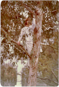
At the 1978 Festival of Kew, a number of organisations, including the City of Kew, the Kew Historical Society, Trinity Boys Grammar School and local Girl Guides participated in a re-enactment of the expedition of the party of Charles Grimes in surveying the Yarra River as far as Kew in February 1803. The location for the event was Yarra Bend Park near the Studley Park Boat House. The event was organised by the Kew Historical Society. The re-enactment was captured by a number of amateur photographers as well as by a photographer from the local Progress Press.Local communities select events to commemorate according to their shared history and values. Commemorations of colonial exploration were popular with local historical groups such as the Kew Historical Society in the twentieth century. In re-enacting events such as the Grimes survey of the Yarra, students from a local school were encouraged to take on specific roles, including play-acting individuals involved in the survey party as well as members of the local Wurundjeri People. The photographs, taken by amateur and professional photographers, represent a period in time when the dominant values were those shared by the descendants of European settlers in Victoria. Original colour photographic positive showing a boy from Trinity Grammar School in a tree, role-playing Captain Robbins, a member of Grimes' survey party.Annotated on reverse: "CAPTAIN ROBBINS LOOKING UP THE YARRA AND REPORTING: 'A LAND THAT OFFERS GREAT OPPORTUNITY FOR SETTLEMENT' / RE-ENACTED BY A TRINITY BOY / 1978 FESTIVAL"kew historical society, trinity grammar school, kew girl guides, city of kew, yarra river, charles grimes, collins expedition, wurundjeri people, yarra bend park, colonial surveys, historic re-enactments, festival of kew, kew festival -
 Kew Historical Society Inc
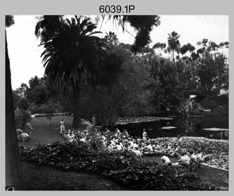
Photograph - Historic re-enactment during the Festival of Kew, 1978
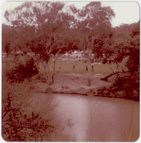
At the 1978 Festival of Kew, a number of organisations, including the City of Kew, the Kew Historical Society, Trinity Boys Grammar School and local Girl Guides participated in a re-enactment of the expedition of the party of Charles Grimes in surveying the Yarra River as far as Kew in February 1803. The location for the event was Yarra Bend Park near the Studley Park Boat House. The event was organised by the Kew Historical Society. The re-enactment was captured by a number of amateur photographers as well as by a photographer from the local Progress Press.Local communities select events to commemorate according to their shared history and values. Commemorations of colonial exploration were popular with local historical groups such as the Kew Historical Society in the twentieth century. In re-enacting events such as the Grimes survey of the Yarra, students from a local school were encouraged to take on specific roles, including play-acting individuals involved in the survey party as well as members of the local Wurundjeri People. The photographs, taken by amateur and professional photographers, represent a period in time when the dominant values were those shared by the descendants of European settlers in Victoria. Original colour photographic positive of the site where the re-enactment of Charles Grimes' survey party of 1803 took place during the Kew Festival of 1978.Annotated on reverse: "GRIMES LANDING SITE / 1978 / DONATED BY MRS DEAN"kew historical society, trinity grammar school, kew girl guides, city of kew, yarra river, charles grimes, collins expedition, wurundjeri people, yarra bend park, colonial surveys, historic re-enactments, festival of kew, kew festival -
 Lakes Entrance Historical Society
Book, Morrissey, D.W and Morrissey E.W, Lakes Entrance a Short History revised Edition, 1980
History of Koorie inhabitants through to fishing industry, timber industry, early settlers and survey and sale of land. The opening of the entrance to allow shipping industry to operate bringing much trade and movement of primary produce etc. Local schoolHistory of Koorie inhabitants through to fishing industry, timber industry, early settlers and survey and sale of land. The opening of the entrance to allow shipping industry to operate bringing much trade and movement of primary produce etc. Local schoolMargaret Campbell''land settlement, religion, aboriginals -
 St Kilda Historical Society
Photograph - Photo map, Department of Crown Lands and Survey, 22/01/1970
One of a series of photo-maps produced for the Department of Crown Lands and Survey (1857-1983). For correlation with a current map, and access to other historical photo maps of Victoria, see the Historic Photo-Maps Index published by the Department of Environment, Land, Water and Planning at https://services.land.vic.gov.au/DELWPmaps/historical-photomaps/Black and white aerial photographCONTROLLED Vic 2358 Department of Crown Lands and Survey Victoria,.© Melbourne 1970 Project Run 41E 22.1.70 5,100 ASL 66st kilda, albert park, st kilda west, catani gardens, st kilda botanical gardens, st kilda pier, st kilda beach, 1970 -
Whitehorse Historical Society Inc.
Map, Parish of Nunawading, 1853
Photocopy of manuscript map with allotments numbered and named.Photocopy of manuscript map with allotments numbered and named. Note on verso: Parish of Nunawading, County of Bourke. Gardiners Creek, Ballyshanassey Township, surveyed by H. Parmein, Surveyor General's office, Nov 30th 1853 [enlargement of ND2801, no list of corner references]Photocopy of manuscript map with allotments numbered and named. maps, gardiners creek, ballyshanassy, burwood east, parmein, h -
 Bendigo Military Museum
Photograph - Army Survey Regiment - Defence Force Service Medal Presentations, Fortuna Villa, Bendigo, 1992
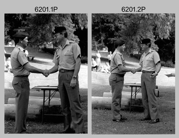
These five photographs were taken at a formal Army Survey Regiment medal presentation at the lakeside of Fortuna on the 11th of December 1992. The CO of the Army Survey Regiment – LTCOL Bob McHenry presented the Defence Force Service Medal to five RA Svy personnel in recognition of 15 years of efficient remunerated service. They were SSGT Greg Byers, SGT Peter Hardy, SGT Garry Kerr, SGT Laurie Justin and WO2 Rhys De Laine. LTCOL Bob McHenry was the CO of the Army Survey Regiment from 1992 to 1993.These five black & white photographs were taken at a Defence Force Service Medal Presentation on the 11th of December 1992 at the Army Survey Regiment, Bendigo. The photographs were printed on photographic paper and are part of the Army Survey Regiment’s Collection. The photographs were scanned at 300 dpi. .1) Photo, black & white, L to R: SSGT Greg Byers and LTCOL Bob McHenry. .2) Photo, black & white, L to R: SGT Peter Hardy and LTCOL Bob McHenry. .3) Photo, black & white, L to R: SGT Garry Kerr and LTCOL Bob McHenry. .4) Photo, black & white, L to R: SGT Laurie Justin and LTCOL Bob McHenry. .5) Photo, black & white, L to R: WO2 Rhys De Laine and LTCOL Bob McHenry..1 to. 5P – annotations identifying personnel and the date provided on paper.royal australian survey corps, rasvy, army survey regiment, army svy regt, fortuna, asr -
 Bendigo Military Museum
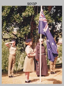
Photograph - Australian Flag Raising Ceremony - Army Survey Regiment, Australia Day, Fortuna, Bendigo, c1995
This photograph of a flag raising ceremony by a contingent from the Army Survey Regiment was probably taken on Australia Day circa 1995. It is not known where this ceremony took place, however it could have been at the front of the parade ground at Fortuna Villa facing Chum St. F454971 LCPL Val (Heaslip) Knight served in the ADF from 27 Oct 1987 to 25 Feb 1996. 330601 CPL Adam Gray served in the ADF from 25 Jul 1990 to 28 Apr 1996.This photograph of a flag raising ceremony by a contingent from the Army Survey Regiment was probably taken on Australia Day on the 26th of January 1995 at Fortuna Villa. The photograph was printed on photographic paper and is part of the Army Survey Regiment’s Collection. The colour photograph was scanned at 300 dpi. .1) - Photo, colour, c1995. L to R: CPL Adam Gray, LCPL Val (Heaslip) Knight, unidentified priest..1P – There are no personnel identified.royal australian survey corps, rasvy, army survey regiment, army svy regt, fortuna -
 Bendigo Military Museum
Photograph - Commanding Officer’s Parade at the Army Survey Regiment, Fortuna Villa, Bendigo, c1977
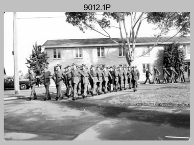
This is a set of three photographs of a Commanding Officer’s (CO’s) Parade held at the Army Survey Regiment, Bendigo in circa 1977. The guest of honour was the City of Bendigo’s Lord Mayor Roy Francis ‘Dick’ Turner. He was the Lord Mayor of Bendigo on three occasions – 1965 to 1966, 1974 to 1975 and 1977 to 1978. The Army Survey Regiment’s key appointments at the time were LTCOL Bob Skitch, the Commanding Officer from 1976 to 1980 and WO1 Aub Harvey, the RSM of the unit from 1976 to 1982. This is a set of three photographs of a Commanding Officer’s (CO’s) Parade held at the Army Survey Regiment, Bendigo in circa 1977. The photographs were printed on photographic paper and are part of the Army Survey Regiment’s Collection. The black and white photographs were scanned at 300 dpi. .1) - Photo, Black & white, c1977. Air Survey Squadron L to R: unidentified (x2), Peter Warwick, Mick Dempster, Andy Wilson, unidentified, Greg Gilbert, remainder unidentified. .2) - Photo, Black & white, c1977. Cartographic Squadron L to R: FLTLT Ron Aitken, CPL Alan Hawkins, unidentified, CPL Stuart Symonds, unidentified (x2), CPL Chris Edwards, SSGT Pat Lumsden, unidentified, PTE Tracey (Beckwith) Phillips, CPL Lynn Johnson, unidentified, CPL Steve Hansen, SGT Rowan Gillies, CAPT Simon Lemon, SGT Alan Toogood, unidentified (x2), CPL John Bennett, remainder unidentified. .3) - Photo, Black & white, c1977. The Army Survey Regiment performs an ‘eyes left salute on the march as it marches past the Guest of Honor. L to R: unidentified, RSM WO1 Aub Harvey, and 2IC MAJ Peter Eddy. The Guest of Honour – City of Bendigo Lord Mayor Dick Turner receives the salute on the front steps of Fortuna Villa. CO LTCOL Bob Skitch standing behind him returns the salute..1P to .3P – There are no personnel identified.royal australian survey corps, rasvy, army survey regiment, army svy regt, fortuna -
 Bendigo Military Museum
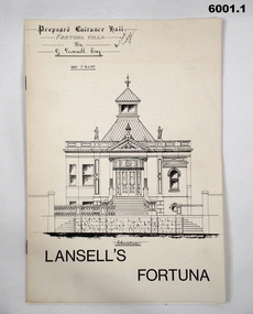
Booklet - Lansell's Fortuna, Army Survey Regiment, Circa 1960
History of Fortuna Villa covering owners and occupiers, the building and the tour during Army tenure. Mentions original owner Christopher Balderstedt, George Lansell and Royal Australian Survey Corps tenures. A number of different versions of this booklet were produced. Each version had a different colour cover. This orange covered edition was the last version produced and printed.6001.1 The white covered version is the first edition of the Fortuna Tour booklet. 6001.2 The orange and off-white covered booklet is the final edition of the Fortuna Tour booklet produced by the Army Survey Regiment, 36 pages, contains black and white photos, colour photos, plans, sketches, maps, diagrams, gloss paper, stapled spline 20cm x 29cm 6001.3 The green covered edition is a second variation of the Army Survey Regiment Tour Bookletroyal australian survey corps, rasvy, fortuna, army survey regiment, army svy regt, asr -
 Bendigo Military Museum
Photograph - AUTOMAP 1 Production – Army Survey Regiment, Fortuna, Bendigo, c1980
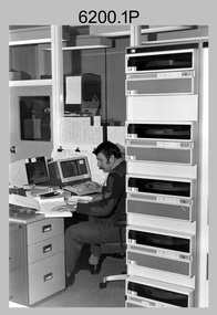
This collection of five photos was most likely taken in c1980. The AUTOMAP 1 computer assisted cartography and mapping system was introduced in 1975. The components of AUTOMAP 1 were the Input Sub-System of four Wild B8s stereoplotters and three Gradicon digitising tables, the Optical Line Following Sub-System – Gerber OLF, the Verification Sub-System – Gerber 1442 drum plotter, the General Purpose Sub-system – HP21MX computer and the Output Sub-System – Gerber 1232 flatbed plotter). The first map was published in 1978 (Strickland 3665-3, 1:50,000). AUTOMAP 1 was the first computer assisted cartography and mapping system utilised by the Survey Corps and was the first system used by Australian mapping organisations. The history of the AUTOMAP 1 system is covered in more detail with additional historic photographs, in pages 116-118 of Valerie Lovejoy’s book 'Mapmakers of Fortuna – A history of the Army Survey Regiment’ ISBN: 0-646-42120-4. See items 6410.24P, 6122.20P, 6183.19P, 6184.20P and 6222.17P for more photos of the AUTOMAP 1 computer system.This is a set of five photographs of Air Survey Squadron military personnel operating AUTOMAP 1 equipment at the Army Survey Regiment at Fortuna, Bendigo, c1980. Black and white photos are on photographic paper and were scanned at 300 dpi. They are part of the Army Survey Regiment’s Collection. .1) - Photo, black & white, c1980, SGT Cliff Webb operating AUTOMAP 1 terminal. .2) - Photo, black & white, c1980, HP21MX computer General Purpose Sub-system. .3) - Photo, black & white, c1980, Gerber verification drum plotter. .4) and .5) - Photo, black & white, c1980, unidentified personnel operating AUTOMAP 1 terminal. .1P to .5P - No personnel are identified.royal australian survey corps, rasvy, army survey regiment, army svy regt, fortuna, asr, automap 1 -
 Bendigo Military Museum
Photograph - 4th Field Survey Squadron - Land Rover Perentie Light Vehicles in the Field, 1987
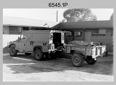
This is a set of nine photographs featuring 4th Field Survey Squadron’s newly introduced Survey variant of the Land Rover Perentie light truck vehicle on a field trip in SA, in 1987. The Land Rover Perentie is a nickname for the Land Rover 110 produced by JRA Limited for the Australian Army, and part manufactured and assembled in Moorebank, New South Wales, during the 1980s and 1990s The name Perentie originates from Land Rover's successful tender to Project Perentie, which was the official Australian Army trial to select new 1 and 2-tonne light vehicles to replace the ageing fleet of Series 2A and 3 Land Rovers. The major differences between the Land Rover Perentie and British Land Rovers were the relocation of the spare wheel to a position under the rear of the load area, a galvanised chassis and the Isuzu engine. The Land Rover Perenties were produced in 4x4 and 6x6 variants and powered by an Isuzu 3.9-litre four-cylinder 4BD1 diesel engine. The Truck, Panel, Lightweight, Survey, FFR, Winch, MC2 model was one of eight 4x4 variants built for the Australian Army. There were 35 Vehicles built to satisfy the operational requirements of RA Svy’s units. Source – Wikipedia. See item 6544.35P for related photos of these vehicles.This is a set of 35 photographs featuring 4th Field Survey Squadron’s newly introduced Survey variant of the Land Rover Perentie light truck vehicle, at Keswick Barracks, Adelaide SA in 1987. The black & white photograThis is a set of nine photographs featuring 4th Field Survey Squadron’s newly introduced Survey variant of the Land Rover Perentie light truck vehicle on a field trip in SA, in 1987. The black & white photographs are on 35mm negative film and are part of the Army Survey Regiment’s Collection. The photographs were scanned at 96 dpi. .1) - Photo, black & white, 1987. Perentie Land Rover with trailer parked outside unknown motel in SA. .2) & .3) - Photo, black & white, 1987. Field trip featuring Perentie Land Rover. .4) - Photo, black & white, 1987. Field trip featuring Perentie Land Rover. Series 3 Land Rover parked behind. Unidentified personnel. .5) & .6) - Photo, black & white, 1987. Field trip featuring Perentie Land Rover. Unidentified personnel. .7) & .8) - Photo, black & white, 1987. Field trip featuring Perentie Land Rover. Typical sandy 4WD track on fence line. .9) - Photo, black & white, 1987. Field trip featuring Perentie Land Rover. Probable gas extraction facility..1P to .9P – There are no personnel identified. ‘PERENTI MOTOR VEHICLES JUL 87’ annotated on negatives sleeve.tified. royal australian survey corps, rasvy, 4 fd svy sqn -
 Bendigo Military Museum
Photograph - Capturing Topographic Features with a Wild B8 – Army Survey Regiment, Fortuna, Bendigo, c1980
These four photographs of SPR Santina (Argetto) Straube capturing topographic features – plotting with a Wild B8 stereo plotter were most likely taken in c1980. Introduced in 1966, the Wild B8 stereo plotter was used for plotting topographic detail and contours. These analogue machines were manually controlled by adjusting the control knobs for the orientation of the 3D image. The B8s used a nine-inch square photo image on a film or glass diapositive which allowed highly accurate extraction of map features. At first, plotting by B8 and B9 equipment was undertaken at the aerial photography scale of 1:80,000 in pencil onto a controlled plotting sheet. Sheets were then inked up and reduced photographically to the 1: 100,000 publication scale for scribe impression production. In these photos SPR Santina (Argetto) Straube was plotting with a pencil or ink pen mounted at the far end of the pantograph arm. The plotting procedure was upgraded to direct plotting in ink with photographic reduction to publication scale. In 1975 four B8s were upgraded with tri-axis locaters as part of the Input Sub-system to enable digital extraction to AUTOMAP 1’s topographic database. When AUTOMAP 2 was introduced in 1982 these B8s were upgraded, and additional machines added to expand the Army Survey Regiment’s digital capture capability. This is a set of four photographs of a technician capturing topographic Features with a Wild B8 stereo plotter in Air Survey Squadron – Army Survey Regiment, Fortuna, Bendigo. 1980. The photographs were on 35mm negative film and were scanned at 96 dpi. They are part of the Army Survey Regiment’s Collection. .1) to .4) Photo, black & white, c1980. SPR Santina (Argetto) Straube operating a Wild B8 stereo plotter..1P to .4P – no annotations.royal australian survey corps, rasvy, army survey regiment, army svy regt, fortuna, asr, air survey, photogrammetry -
 Bendigo Military Museum
Photograph - 4th Field Survey Squadron – Operation MIZMAZE 92, Kimberley region, Western Australia, 1992
This is a set of 40 photographs taken in 1992 during 4th Field Survey Squadron’s deployment on Operation MIZMAZE 92 in the Kimberley region of Western Australia from the 13th of May to the 14th of July 1992. The area of operations was Wyndham, Halls Creek and Sandfire Flat. It was a two-part operation involving the field completion of topographic maps and the acquisition of mapping control by GPS field parties utilising Texas Instruments TI4100 Global Positioning System receivers. Survey parties conducted field checking of topographic maps and GPS control acquisition in Perentie 110 Series Survey variant FFR Land Rovers. Three Bell Kiowa LOH helicopters provided by 162 Recce Sqn supported field checking and limited deployment of GPS surveys parties. C-l30 Hercules from 36 Sqn supported deployment and extraction of personnel and equipment to and from from the AO. A Cessna 404 Titan Ambassador from Vee-H Aviation was used as the Wild RC10 camera platform for aerial photography acquisition.This is a set of 40 photographs taken in 1992 during 4th Field Survey Squadron’s deployment on Operation MIZMAZE 92 in the Kimberley region of Western Australia. The colour photographs are on 35mm negative film and are part of the Army Survey Regiment’s Collection. The photographs were scanned at 96 dpi. .1) - Photo, colour, 1992. CAPT Craig Hersant. .2) - Photo, colour, 1992. Unidentified officer/soldier. .3) & .4) - Photo, colour, 1992. Aboriginal rock art - Wandjina Gunduran, Donkey Creek. .5) - Photo, colour, 1992. Aboriginal rock art - Track Wandjinas, Donkey Creek. .6) & .7) - Photo, colour, 1992. CAPT Craig Hersant. .8) - Photo, colour, 1992. Kimberley region topography. CPL Glen Weatherell. .9) - Photo, colour, 1992. Unidentified personnel .10) - Photo, colour, 1992. Supermarket at unknown location. .11) to .13) - Photo, colour, 1992. Caravan park at unknown location. .14) - Photo, colour, 1992. Old bridge at Fitzroy Crosssing. .15) & .16) - Photo, colour, 1992. Survey party in Perentie 110 Series Land Rover. .17) & .18) - Photo, colour, 1992. Kimberley region topography. .19) - Photo, colour, 1992. Kimberley region topography. CPL Glen Weatherell. .20) - Photo, colour, 1992. Kimberley region topography, possibly the Bungle Bungles. .21) - Photo, colour, 1992. Kimberley region topography. SGT Frank Downie. .22) - Photo, colour, 1992. Kimberley region topography: the Bungle Bungles. .23) - Photo, colour, 1992. Kimberley region topography: the Bungle Bungles. .24) - Photo, colour, 1992. Kimberley region topography: the Bungle Bungles. SPR Neil Pedler. .25) & .26) - Photo, colour, 1992. Kimberley region topography: the Bungle Bungles. .27) - Photo, colour, 1992. Kimberley region topography. .28) - Photo, colour, 1992. Survey party with Perentie 110 Series Land Rover. .29) - Photo, colour, 1992. Kimberley region topography. .30) - Photo, colour, 1992. Survey party outside Perentie 110 Series Land Rover. .31) & .32) - Photo, colour, 1992. Survey party operating TI4100 GPS Receiver next to Perentie 110 Series Land Rover. SGT Eddie Jacobs. .33) & .34) - Photo, colour, 1992. Survey party operating TI4100 GPS Receiver next to Perentie 110 Series Land Rover. Unidentified surveyor. .35) - Photo, colour, 1992. Kimberley region topography. Hand water pump at well. .36) - Photo, colour, 1992. Survey party in Perentie 110 Series Land Rover. .37) - Photo, colour, 1992. Kimberley region topography. CPL Glen Weatherell. .38) - Photo, colour, 1992. Kimberley region topography viewed from Bell Kiowa LOH helicopter. .39) & .40) - Photo, colour, 1992. Unidentified surveyor field checking a preliminary map in a Bell Kiowa LOH helicopter..1P to .40P – There are no personnel identified. ‘1992 OP MIZMAZE annotated on negative sleeve.royal australian survey corps, rasvy, 4 fd svy sqn, op mizmaze 92 -
 Bendigo Military Museum
Photograph - Various Photos - Army Headquarters Survey Regiment, Fortuna, Bendigo, c1950s to 1960s
This is a collection of five photographs taken at the Army Headquarters Survey Regiment, Fortuna Villa, Bendigo, circa 1950s to 1960s. Appearing in photo .3P is MAJ Edward Anderson MBE, who served from 1942 to 1977 and reached the rank of LTCOL. LT Frank Thorogood SB St J. served from 1960 to 1981. He reached the rank of LTCOL and was the CO of the Army Survey Regiment from 1980 to 1981. CAPT W. Greer’s service history is unknown. Appearing in photo .5P is MAJ Nolan, who served from 1939 to 1975. He was promoted to LTCOL and was the CO of the Army Headquarters Survey Regiment from 1965 to 1969. He was subsequently promoted to COL and was the Director of Military Survey from 1972 to 1975.This is a collection of five photographs taken at the Army Headquarters Survey Regiment, Fortuna Villa, Bendigo, circa 1950s to 1960s. The photographs were printed on photographic paper and are part of the Army Survey Regiment’s Collection. They were scanned at 300 dpi. .1) - Photo, black and white, 1950s. Regiment briefings by Fortuna’s lake. .2) - Photo, black and white, 1960s. Unidentified officer and civilian visitors in the Officers Mess. .3) - Photo, black and white, 1960s. L to R: MAJ Edward Anderson MBE, CAPT W. Greer and LT Frank Thorogood SB St J; in the Officers Mess. .4) - Photo, black and white, 1962. Regiment parade held in Fortuna’s grounds where the tennis and basketball courts were later developed. .5) - Photo, black and white, 1960s. MAJ John Nolan (centre) with unidentified civilian visitors.Personnel were identified in photos .3P and .5P. The date is annotated on photo .4P.royal australian survey corps, rasvy, army survey regiment, army svy regt, fortuna, asr -
 Waverley RSL Sub Branch
Print Gentlemen The Queen, Gentlemen The Queen
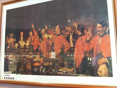
Original Painting in Bendigo Art Gallery PAINTING WON'T HANG IN MESS BENDIGO intends to keep its big oil painting, "Gentlemen - the Queen," hanging in the Shamrock Hotel in Pall Mall. i The painting is on loan to the hotel from the Bendigo Art Gallery. And It's badly wanted at the officers' mess of the Royal Australian Artillery, 3rd Div., in Batman av., Melbourne. A formal application for It was made, In writing, to the Art Gallery by Brigadier W. Hall, commanding offlfncer. But Art Gallery members at their meeting yesterday said "No." Lending it or giving it away would "create a dan- gerous precedent for the Gallery," they decided. . "Any anyway," said Mr. W. Little, the Gallery's curator, "Brig. Hall has erred in thinking the men depicted in the painting are artillerymen. "They're offlfflcers In the Duke of Connaught's Light Infantry." But in Melbourne last night Brigadier Hall, keenly disappointed, said: VI have been told the picture was painted in the Royal Artil- lery mess at Woolwich, In England. "I have never dauhted the men are artillerymen, be- cause they wear the gun- ners' blue mess Jacket, scar- let cuffs and scarlet waist- coat." The Argus Tuesday 8 September 1953 Digitalised http://trove.nla.gov.au/ndp/del/article/23307813/1762840?zoomLevel=3Colour print of a painting by Albert Chevallier Taylor in wooden frame Glass frontedCopy by Survey Regiment 1986gentlemen the queen, argus newspaper, bendigo art gallery. -
 Bendigo Historical Society Inc.
Map - STRUGNELL COLLECTION: HUSTLER'S LINE OF REEFS, BENDIGO, September 1913
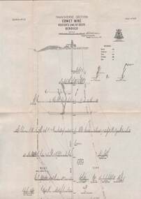
Map, Hustler's Line of Reefs, Comet Mine, Transverse Section, Plate No.XXV (25). Bulletin No 33 Signed H.A.Whitelaw. Drawing shows the vertical shaft descending to over 1692 feet and appears to show samples of connecting horizontal shafts with their respective mineral contentsUnderground Survey Office, Bendigo.map, bendigo, comet mine -
 Bendigo Historical Society Inc.
Map - STRUGNELL COLLECTION: HUSTLER'S LINE OF REEFS, BENDIGO, September 1913
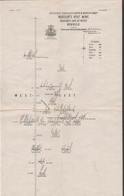
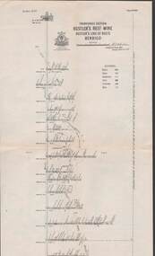
Map, Hustler's Line of Reefs, Hustler's Reef Mine, East & West Cross-Cuts, North & South of Shaft. Plate No. X1X (19).Bulletin No 33 Signed H.A.Whitelaw. Drawing shows the vertical shaft descending to over 1296 feet and appears to show samples of connecting horizontal shafts with their respective mineral contentsUnderground Survey Office, Bendigo.map, bendigo, hustler's reef mine -
 Bendigo Historical Society Inc.
Map - STRUGNELL COLLECTION: HUSTLER'S LINE OF REEFS, BENDIGO, September 1913
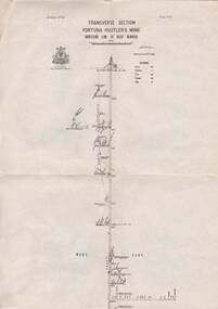
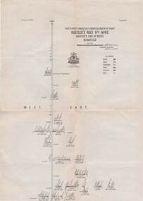
Map, Hustler's Line of Reefs, Fortuna Hustler's Mine, Bendigo, Transverse Section. Plate Mo.111(3).Bulletin No 33 Signed H.A.Whitelaw. Drawing shows the vertical shaft descending to over 2228 feet and appears to show samples of connecting horizontal shafts with their respective mineral contentsUnderground Survey Office, Bendigo.map, bendigo, fortuna hustler's mine -
 Bendigo Historical Society Inc.
Map - STRUGNELL COLLECTION: HUSTLER'S LINE OF REEFS, BENDIGO, September 1913
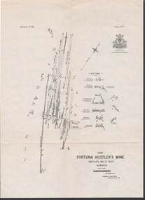
Map, Hustler's Line of Reefs, Fortuna Hustler's Mine, Plan, Plate No.11(2).Bulletin No 33 Signed H.A.Whitelaw.Underground Survey Office, Bendigo.map, bendigo, fortuna hustler's mine -
 Bendigo Historical Society Inc.
Map - STRUGNELL COLLECTION: HUSTLER'S LINE OF REEFS, BENDIGO, September 1913
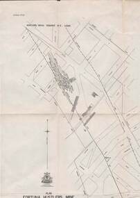
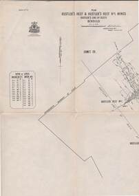
Map, Hustler's Line of Reefs, Bendigo, Plan Fortuna Hustler's Mine, Hustler's Royal Reserve No. 2 Lease. Plate No.1(1) Bulletin No 33 Signed H.A.Whitelaw.Underground Survey Office, Bendigo.map, bendigo, fortuna hustler's mine -
 Bendigo Historical Society Inc.
Map - STRUGNELL COLLECTION: HUSTLER'S LINE OF REEF, BENDIGO
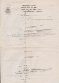
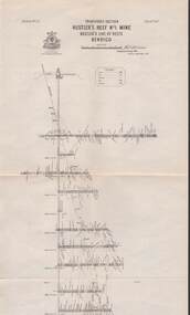
Map, Hustler's Line of Reef, Bendigo, Fortuna Hustler's Mine, Longitudinal Section. Plate No. 1V (4). NOTE--- Plates 4,8,13,29,26 & 31 form a Longitudinal Section from Fortuna Hustler's to Hustler's Consols Mine.Bulletin No 33 Signed H.A.Whitelaw. Drawing shows the vertical shaft descending to over 2228 feetUnderground Survey Office, Bendigo.map, bendigo, fortuna hustler's mine -
 Bendigo Historical Society Inc.
Map - STRUGNELL COLLECTION: HUSTLER'S LINE OF REEFS, September 1913
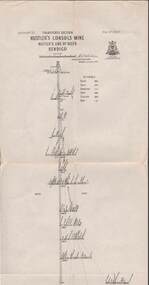
Map, Hustler's Line of Reefs, Hustler's Consols Mine, Transverse Section, Bendigo.Plate no. XXX111 (33).Bulletin No 33 Signed H.A.Whitelaw. Drawing shows the vertical shaft descending to over 1326 feet and appears to show samples of connecting horizontal shafts with their respective mineral contentsUnderground Survey Office, Bendigo.map, bendigo, hustler's consols mine -
 Bendigo Historical Society Inc.
Map - HUSTLER'S LINE OF REEFS, September 1913
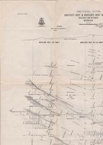
Map, Hustler's Line of Reefs, Hustler's Reef & Hustler's Reef No. ! Mines, Bendigo, Longitudinal Section,Plate No.XX (20). NOTE-- Plates 4,8,13,20,26 & 31 form a Logitudinal Section from Fortuna Hustler's to Hustler's Consols Mine.Bulletin No 33 Signed H.A.Whitelaw. Drawing shows the vertical shaft descending to over 1601 feetUnderground Survey Office, Bendigo,map, bendigo, hustler's reef & hustler's reef 1 -
 Bendigo Historical Society Inc.
Map - STRUGNELL COLLECTION: HUSTLER'S LINE OF REEFS, September 1913
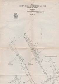
Map, Hustler's Line of Reefs, Hustler's Reef & Hustler's Reef No1 Mines Plan, Bendigo.Plate No. XV11 (17).Bulletin No 33 Signed H.A.Whitelaw.Underground Survey Office, Bendigo.map, bendigo, hustler's reef & hustler's reef 1 -
 Bendigo Historical Society Inc.
Map - STRUGNELL COLLECTION: HUSTLER'S LINE OF REEFS, September 1913
Map, Hustler's Line of Reefs, Hustler's Reef Mine, Transverse Section, Bendigo. Plate No. XV111 (18).Bulletin No 33 Signed, H.A.Whitelaw. Drawing shows the vertical shaft descending to over 2195 feet and appears to show samples of connecting horizontal shafts with their respective mineral contentsUnderground Survey Office, Bendigo.map, bendigo, hustler's reef mine -
 Bendigo Historical Society Inc.
Map - STRUGNELL COLLECTION: HUSTLER'S LINE OF REEF'S. HUSTLER'S REEF NO.1 MINE, September 1913
Map, Hustler's Line of Reefs, Hustler's Reef No. 1, Bendigo, East & West Cross-cuts, North & South of Shaft, Plate No.XX11 (22). Bulletin No 33 Signed H.A.Whitelaw. Drawing shows the vertical shaft descending to over 1229 feet and appears to show samples of connecting horizontal shafts with their respective mineral contentsUnderground Survey Office, Bendigo.map, bendigo, hustler's reef no.1 mine -
 Bendigo Historical Society Inc.
Map - STRUGNELL COLLECTION: HUSTLER'S LINE OF REEF, September 1913
Map, Hustler's Line of Reefs, Hustler's Reef & Hustler's Reef No.1 Mines Bendigo.Plate No. X1V (14) Comet Co. .Bulletin No 33 Signed H.A.Whitelaw. Drawing shows reef boundary lines .There is an explanatory box showing depth in feet and inches of the mines .Underground Survey Office, Bendigo.map, bendigo, hustler's reef & hustler's reef 1 -
 Bendigo Historical Society Inc.
Map - STRUGNELL COLLECTION: HUSTLER'S LINE OF REEFS, September 1913
Map, Hustler's Line of Reefs, Hustler's Reef No.1 Mine Bendigo, Transverse Section.Plate No. XX1 (21).Bulletin No 33 Signed H.A.Whitelaw. Drawing shows the vertical shaft descending to over 1428 feet and appears to show samples of connecting horizontal shafts with their respective mineral contentsUnderground Survey Office, Bendigo.map, bendigo, hustler's reef no.1 mine -
 Bendigo Historical Society Inc.
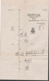
Map - STRUGNELL COLLECTION: UNITED HUSTLER'S & REDAN MINE, September 1913
Map, Transverse Sections N. & S. Of shaft, United Hustler's & Redan Mine, Hustler's Line of Reef, Bendigo. Plate No. XXX (30).Bulletin No 33 Signed H.A.Whitelaw. Drawing shows the vertical shaft descending to over 976 feet and appears to show samples of connecting horizontal shafts with their respective mineral contentsUnderground Survey Office, Bendigo.map, bendigo, hustler's & redan mine