Showing 863 items matching "surveyors"
-
 Federation University Historical Collection
Exercise Book, William Baragwanath, William Baragwanath's Exercise Book, 1898, 1898
William Baragwanath studied at the Ballarat School of Mines, obtained a Geology certificate in 1911. He was born on 01 August 1878 at Ballarat. He joined the Victorian Department of Mines in 1897 and was Chief Mining Surveyor from 1924 to 1943. Baragwanath died at Prahran on 20 Septemeber 1966.Marbled blue card covered exercise book with yellow tape spine containing handwritten notes by William Baragwanath on dividing land problems, earthworks, refraction, etc; Headings include: Tom Joe Smith ballarat school of mines, earthworks, land problems, refraction, william baragwanath, -
Federation University Historical Collection
Book, A text-book of Euclid's elements: for the use of schools, 1894
Owned by William Baragwanath who studied at Schools of Mines Ballarat. He became council member of the school of mines from 1916-50. William Baragwanath (1878-1966), surveyor, geologist and public servant, was born on 1 August 1878 at Durham Lead near Ballarat, Victoria.Worn, maroon cloth bound book with gold printing on the spine. It is illustrated and is 430 pages long.In pen inside leaf - W. Baragwanath, SMB (crossed out), School of Mines, Ballarat Vic In pen on title page - Series of numbers and [illegible] be able to quote any by number. Inside in pencil and pen - various drawings and numbers.william baragwanath, a text book of euclid's elements, h s hall, f h stevens, school of mines ballarat, geology, mathemathics -
 Ringwood and District Historical Society
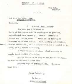
Administrative record - Borough of Ringwood 17/7/51 report to Mayor and Councillors, Document from C Merry, Building Surveyor Ringwood East Reserve
Building report Ringwood East Reserve from C Merry, Building Surveyor and Mr Lucas to the Mayor and Councillors Borough of Ringwood 17/7/51. Building can be jacked up and reblocked where necessary. 300' of flooring is necessary in the west section. Roof, spouting and downpipes require overhauling. Needs some repair work inside and outside. Estimated cost 220 pounds. -
Bendigo Historical Society Inc.
Map - MAP WHITE HILL TO HUNTLY
Map of Bendigo creek and adjacent leads - White Hills to Huntly replotted from old 4 chain to 1 inch survey of 1860 by G. W. Hart - Surveyor. Base of roads and streets taken from D.L.S. 1 . 10000 base maps. Legend: battery site, puddling mill site, dam bank site, cutting altering course of creek, lead boundaries.bendigo, mining -
 Bendigo Military Museum
Pamphlet - Army Headquarters Survey Regiment Tour Booklet 1964, Army Headquarters Survey Regiment, Circa 1964
It is believed that this booklet was produced for visitors to a Fortuna Villa Open Day in 1964. Contains historical photos of the Fortuna Villa Entrance Hall and Music Room. Army Occupied Fortuna from 1942 - 1996.Printed buff coloured photo of Australia on a 4 x page folded A5 booklet. Contains a black printed Survey Corps badge , Surveyor characture and Title "Army Survey Headquarters Survey Regiment" on the cover. The booklet contains other selected early photographs of Fortuna and a diagram of the layout of the grounds. Pages 3 and 4 contain photographs and descriptions of Field surveying from the period."Public Inspection at 'Fortuna' Bendigo 10th May 1964" Donation 2/- royal australian survey corps, rasvy, fortuna, army survey regiment, army svy regt, asr -
 Bendigo Military Museum
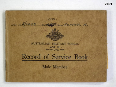
Administrative record - RECORD OF SERVICE BOOK, KOREA, Australian Government, Record of Service, 1950
Norman Tupper, refer Cat No 6860. 51455 Norman Tupper RAR Korea served 3 Apr 1952 - 24 Mar 1953 Qualified as a driver 1954 Transferred to the Royal Australian Survey Corps in 1955, qualified as a Surveyor Topo 1956 and was promoted Corporal in 1956, discharged 13 July 1956.Book, Australian Military Forces, Record of Service, Male Member. Brown cardboard cover, printed black ink, Commonwealth of Australia crest."Army No: 5/1455 Rank: CPL Name: Tupper N"documents - army records, military history - service records, passchendaele barracks trust, royal australian survey corps -
 Ringwood and District Historical Society
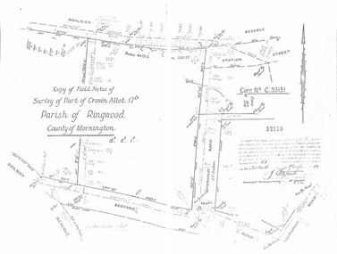
Document - Copy of Lands Department Field Notes - Parish of Ringwood, Victoria, Field Notes - Part of Crown Allotment 17D Surveyed 1952 (Amended in 1953)
5616b Double foolscap size photocopy of survey map with handwritten notations. References include Corr no. C.93151, Railway Reserve, Station Street, Bedford Road, multiple post & wire fences, multiple galv iron pipes put in, Government Road (Hill Street), Tooronga Road, multiple recent pegs found, Certification 52710 by J. Fitzgerald Licensed Surveyor 17/3/1952. -
 Bendigo Historical Society Inc.
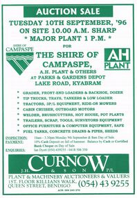
Document - IAN DYETT COLLECTION: AUCTION CATALOGUE - THE SHIRE OF CAMPASPE, A H PLANT & OTHERS
White catalogue with green printing for a sale on the 10th September, '96 on account of The Shire of Campaspe, A. H. Plant & Others. For sale were tip trucks, grader, tractors, cabin cruiser, welder, garden equipment, scrap, tools, surveyors equipment, office furniture, computer equipment, safe, fuel tanks, concrete drains & pipes and sheds. J. H. Curnow & Son P/L were the auctioneers.business, auctioneers, j h curnow & son pty ltd, ian dyett collection - auction catalogue - the shire of campaspe a h plant & others, ian dyett, j h curnow & son p/l, noel dyett, fred dyett -
 Warrnambool and District Historical Society Inc.
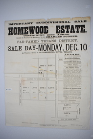
Original document, Advertising "Homewood Estate" Terang, 1886
This notice advertises the sale of the Homewood property near Glenormiston. The sale details state that the property is 2386 acres adjoining "The Sisters" the station of the Black Brothers. The property lies on the main metal road from Terang to Ellerslie, six miles from Terang. It has frontage to Pejark Marsh/drain. It was to be surveyed and sold in blocks of 250 to 300 acres with permanent water and well covered with grasses. The sale of the property followed the death of Charles Podger who died in 1886. On his death he left his wife Ann and six children.His worth was over 20000 pounds with 16000 pounds as real estate and 4300 pounds in personal propertyThe Agent for the sale was James Jellie, solicitors were Warrnambool firm Klingender and O'Mahony and the advertisement was printed by Thomas Smith Gas printing Works Warrnambool. This document has local interest and significance as an early sales of land in the district. The names of agents , solicitors and printers were wll known in the area and the property also a large holding. The Podger name is also well represented in the district to this day.Large white rectangular sheet of paper with black text . Major sale details in heavy black text at the top with descriptive text accompanying map of subdivision of the property on the left.The following names and details are contained within the document. Homewood Estate, Charles Podger, Commercial Hotel Terang, James Jellie Fenelon Mott Surveyor, Klingender & O'Mahony solicitors, Thos, Smith Gas Printing Koroit Street Warrnamboolcharles podger, homewood estate, klingender, o"mahony, kolora, the sisters, terang -
 Ringwood and District Historical Society
Map, Plan of Subdivision Parish of Ringwood, Victoria - c.1960
Black and white photocopied plan - Part of Crown Allotments 14A and 40A showing blocks in Sharps Court and Salsibury Court, Heathmont. Some blocks showing sale price.K.J. Noonan & Co. Licensed Land Surveyors, Suite 16 "Gloucester Lodge", 445 StKilda Road, Melbourne S.C.2, Telephone BM 1631. References to coloured easements etc., not evident from b&w photocopy. -
Clunes Museum
Map, DEPARTMENT OF MINES, Untitled, c1859
All maps show names and locations of mines operating in the district (see reference section link to article).1 Map of Creswick Clunes - lists 45 mines in the Clunes enlargement and 100 mines in the Creswick enlargement .2 Department of Mines map of Clunes Creswick and shows the McDonald & Co. Pre-emptive area. Indexes for quartz and alluvial mine locations .3 Topographical map Ref GF23 Clunes Mt. Greenock Talbot.1 360 Scale 1:2500 .2 303/59 33 hand written in ink "received 15 October 1859" signed by R Broughton, James Stevenson - District Mining Surveyor .3 40 chains to an Inchgold mining, dept of mines -
 Melbourne Legacy
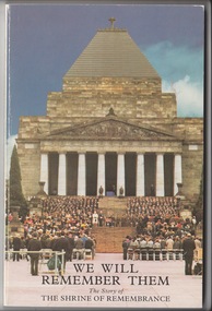
Book, We Will Remember Them. The Story of The Shrine of Remembrance, 1988
The book is about how the Shrine was built. It relates to the proposal, design competition and how the shrine was almost not built. It details the fight by Legacy for the plan to go ahead. Also the ray of light and Legatee Frank Doolan's work as surveyor. It was written by WB Russell who also wrote a biography about Legatee Stan Savige. A record of the building of the Shrine of Remembrance including Legacy's important role. Softcover book x 100 pages about the building of the Shrine.memorial, shrine of remembrance, w b russell -
 Bendigo Military Museum
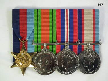
Award - MEDAL SET WW2, Post 1945
Jack Smethurst enlisted in the AIF on 2.7.40 in the 2/1st Australian Survey Regiment. The 2/1st Australian Survey Regiment was a Royal Australian Artillery Regiment. On discharge from the AIF 13.5.46 his rank was Staff Sergeant. (Artillery Surveyor) Refer 549.4, 550.2, an older brother who died in WW1. 558.6.Medals, court mounted, set of (4) re J Smethurst. 1. 1939-1945 Star 2. Defence Medal 3. War Medal 1939-1945 4. Australian Service Medal 1939 - 45"VX28896 J Smethurst"numismatics-medals-military, metalcraft, royal australian artillery -
Eltham District Historical Society Inc
Document - Folder, Murphy, James and descendants
James Murphy was a mining surveyor involved with the Caledonia diggings. Contents Note from Ray Blake, 26 April 2000: Ms Murphy said her people had traditionally owned all of inner Melbourne, north to the Great Divide, West to Werribee River, East to Mt Baw Baw, South to Mordialloc Creek.Newspaper clippings, A4 photocopies, etcjames murphy -
 Orbost & District Historical Society
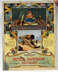
magazines, Banks & Company, Peter Dawson Distiller, 1907
This is the 14th edition of the magazine. This magazine belonged to William Hunter (1893-1971), a resident of Tatura and Mallacoota. He was a soldier, surveyor and amateur naturalist. Peter Dawson was a Distiller and Whisky Merchantat 99 Maxwell Street, Glasgow. By 1891 Dawson had already made a name for himself in the United Kingdom as a blender of whisky and practical distiller. This item is associated with William Hunter.A magazine / catalogue with a cover showing coloured illustrations of military weapons and ordinance. At the bottom is "Peter Dawson Distiller Dufftown & Glasgow" in red and black print inside an ornate gold frame."William Hunter"hunter-william dawson-peter-distiller magazine-weapons-ordinance -
 Orbost & District Historical Society
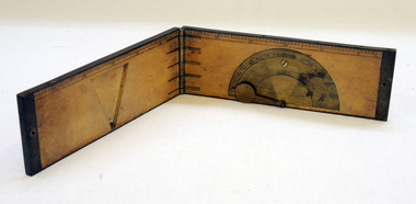
clinometer rule, mid 19th -earl 20th century
This clinometer, is a hand-held optical scientific instrument used in surveying to measure vertical angles. It is used to measure the angle of elevation from the ground in a right-angled triangle. It may have been used by a surveyor or a forester to measure the height of tall things where you couldn't possibly reach to the top of e.g. flag poles, buildings or trees.This item is an example of an early hand held measuring instrument.. Today the use of electronic sensors is an important component in the design and function of the clinometers.A rectangular wooden folding measuring instrument. the panels are brass framed. Inside is a brass semi-protractorgraduated 90-0-90' with index arm pointeran dwith a graduated edge in inches. Outside is a temperature conversion scale,Troughton & Simms, LONDONscientific-instrument measurement clinometer -
 Federation University Historical Collection
Book - Exercise Book, Astronomy Notes by William Baragwanath, 1897
William Baragwanath studied at the Ballarat School of Mines, obtained a Geology certificate in 1911. He was born on 01 August 1878 at Ballarat. He joined the Victorian Department of Mines in 1897 and was Chief Mining Surveyor from 1924 to 1943. Baragwanath died at Prahran on 20 September 1966. See Book 2 - Catalogue Number 4530Marbled card covered exercise book with brown tape spine containing handwritten notes by William Baragwanath on Astronomy and astronomical, geodetic, geights and distances, North Line Latitue, Lime, etc., problems . Headings include: Astronomy refraction Correction for Semi diameter Determination of True Meridian Elongation Observation Latitude Determining the TIme Convergence of Meridian Barometric Measurement of Heights Formulae Latitude Observation On the Division of Land Calculations for Observations by a Single Altitude Computations Triginometrical Rations of Two Arcsballarat school of mines, astronomy, william baragwanath -
 Federation University Historical Collection
Book, Ballarat School of Mines Invoice Book, 1870 - 1875
Scrap book containing invoices relating to accounts to be paid by the Ballarat School of Mines between 1870 until 1875. The School of Mines at Ballarat was the first school of Mines in Australia and was established in 1870. The works done to the former Ballarat Circuit Court House were overseen by Robert Davidson (architect and Surveyor) with the contractor being James Williams. Large book, green leather with red binding, numerous original invoices pasted onto the pages. The first pages of the scrapbook includes correspondence relating to the refurbishment of the former Ballarat Court House which was used as the Ballarat School of Mines from 1870. The building was demolished c1913 to make way for the Ballarat Technical Art School (still standing). * 23 August 1870 - Bateman, Clark & Co, The Ballarat Courier * August 1870 - Klug Bros. Furniture and Bedding Warehouse * April 1870 - J. Armstrong * Statement of Receipts and Expenditure from 23rd Aug. 1870 to 19 January 1871 * W. Gooch, * 1870 - William L. Mullen, Ballarat Stationery Warehouse & Printing Office, * 31Jany. 1871 - A.H. King, Iron Merchant, * 1 February 1871 - Richard Tunbridge, Timber Merchant, * January 4th 1871- Henry Gough, * 8th March 1871 William Murfet, * March 1871- Maxwell Morrow, * 1 February 1871- James Curtis, Caxton Steam Printing Works, * May 4th 1871 - William Blomeley, Iron and Brass Founder, * 4 May 1871 - Thomas Rogers, Draper, Milliner, Haberdasher & c. * May14 1871- George Shannon & Co, Importers of China, Glass & Earthenware, * May 31st 1871, Wreford & Co, Machine Printers, *1st July 1871 William McCulloch & Co,( late Reynolds and English) General Carriers to all parts of the Colony, * 1871- J.J. McDonald, Plumber and Gas Fitters, * August 29th 1871 - Eyres Brothers, Furnishing and General Ironmongers, * 1st August 1871, Frank Pinkerton,H Ben. Franklin Printing and Stationary House 18, Armstrong Street, Ballarat. * 12TH July 1871 J. Donovan, * 10th August, 1871 - Edward Rand, Wholesale Druggist & Importer, *11 Nov 1871 - Matthew Hamilton, * October 2nd 1871 - C.B. Retallack, Engineer and General Smith, *December 8 1871 - James Harrington, * June 1871 - Wayne, Wholesale Druggist * 21st Nov. 1871 - Smith Brothers, Timber Merchants. * 5 January 1872 - T. Eggington, Carpenter, * 12 January 1872 - James Fayle, Plumbers & Ironwork * January 26th 1872 - S. Stansfield, * August 10th 1872 - John H. Hammond Wholesale and Retail, Bookseller, Commercial and General Stationer, etc. etc."VOUCHER" inscribed on spine in gold Each invoice pasted into the scrapbook has a number written onto it. The numbers are in chronological order at start at 1 in each calendar year. ballarat school of mines, redmond barry, hugh gray, henry richards caselli, henry caselli, joseph flude, ballarat court house, harrie wood, clock, invoice book, robert davison, james williams, ballarat circuit court house, old ballarat court, emanuel steinfeld, j.t. sleep, c.b. retallack, john phillips, eyres bros, ballaarat gas company, national insurance company, broadbent bros, charles evans, niven and co, william johnson, william ford, george robertson, william vale, m.d. hamilton, plumbago crucible company, morgans crucibles, h.r. caselli, henry richards caselli, george evans, bateman, clark & co,, klug bros., j. armstrong, w. gooch,, william l. mullen, a.h. king, richard tunbridge, henry gough,, william murfet,, james curtis, william blomeley,, thomas rogers, george shannon, wreford, william mcculloch, j.j. mcdonald, frank pinkerton, ben franklin printing and stationary house, j. donovan, edward rand, matthew hamilton, c.b. retallack,, james harrington, smith brothers,, james fayle,, maxwell morrow,, s. stansfield, walhalla, brunswick house, t rogers -
Federation University Historical Collection
Book - Exercise Book, William Baragwanath, Astronomy Notes Volume 2, 21/06/1897
William Baragwanath studied at the Ballarat School of Mines, obtained a Geology certificate in 1911. He was born on 01 August 1878 at Ballarat. He joined the Victorian Department of Mines in 1897 and was Chief Mining Surveyor from 1924 to 1943. Baragwanath died at Prahran on 20 Septemeber 1966. See Book 2 - Catalogue Number 4530Marbled card covered exercise book with black tape spine containing handwritten notes by William Baragwanath on astronomical problems . Headings include: Observed Altitude of Moons Algebra trigonometry Spherical Trigonometry Definitions in Astronomyballarat school of mines, astronomy, william baragwanath -
 Bendigo Historical Society Inc.
Negative - DUDLEY HOUSE COLLECTION: NEGATIVES OF DUDLEY HOUSE PLUS 3 IMAGES
Dudley House brick building is one of the earliest and most intact 1850s buildings remaining in Bendigo CBD. Like all government buildings of this era, its exterior is fairly modest, unlike the opulent styles of later decades. It was originally built as a residence for the district surveyor, who designed the Bendigo street layout that we still use to this day. Strip of Photo Negatives of Dudley House in View Street Bendigo, Victoria Australia. 3 Images date unknown, but car parked out of front of property is from the 1960s. Looks like a wooden fence is enclosing the property can we date image from this?bendigo, buildings, dudley house -
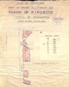 Ringwood and District Historical Society
Map - Plan of Subdivision, Part of Crown Allotment 40C, Parish of Ringwood, County of Mornington - (Undated, circa 1940s)
Copy of land title map in manilla folder showing layout and size of residential allotments in Allens Road Heathmont, Victoria.J.S. Watson & Associates, Surveyors & Chartered Engineers, 7 Main Street Mornington, (Tel) Mornington 86. Typewritten sales notations attached for some allotments with rubber stamp impression - H.G. McLean, Builder, 5 Whitehorse Road, Ringwood. -
 Kew Historical Society Inc
Plan - Subdivision Plan, High Street, Kew, 1920-1935
Pru Sanderson, in her groundbreaking ‘City of Kew Urban Conservation Study : Volume 2 - Development History’ (1988), summarised the periods of urban development and subdivisions of land in Kew. The periods that she identified included 1845-1880, 1880-1893, 1893-1921, 1921-1933, 1933-1943, and Post-War Development. These periods were selected as they represented periods of rapid growth or decline in urban development. An obvious starting point for Sanderson’s groupings involved population growth and the associated economic cycles. These cycles also highlighted urban expansion onto land that was predominantly rural, although in other cases it represented the decline and breakup of large estates. A number of the plans in the Kew Historical Society’s collection can also be found in other collections, such as those of the State Library of Victoria and the Boroondara Library Service. A number are however unique to the collection.The Kew Historical Society collection includes almost 100 subdivision plans pertaining to suburbs of the City of Melbourne. Most of these are of Kew, Kew East or Studley Park, although a smaller number are plans of Camberwell, Deepdene, Balwyn and Hawthorn. It is believed that the majority of the plans were gifted to the Society by persons connected with the real estate firm - J. R. Mathers and McMillan, 136 Cotham Road, Kew. The Plans in the collection are rarely in pristine form, being working plans on which the agent would write notes and record lots sold and the prices of these. The subdivision plans are historically significant examples of the growth of urban Melbourne from the beginning of the 20th Century up until the 1980s. A number of the plans are double-sided and often include a photograph on the reverse. A number of the latter are by noted photographers such as J.E. Barnes.A roughly drawn and faded actual or projected subdivision of a parcel of land bordering on High and Mary Streets. The plan shows five allotments facing High Street and at their rear, another allotment facing Mary Street. In 1906, when the Board of Works surveyors completed Detail Plan 1589, the allotment in Mary Street is shown to include a building. The section of land attached to this building is shown to be undeveloped, thus making a further subdivision possible.subdivision plans - kew, high street -- kew (vic.), mary street -- kew (vic.) -
 Melbourne Tram Museum
Drawing, "Plan of Survey of Part of Crown Allotments 15 and 16 at Hawthorn, Parish of Boroondara, County of Bourke", 1922
Drawing, coloured with water based drawing wash, titled "Plan of Survey of Part of Crown Allotments 15 and 16 at Hawthorn, Parish of Boroondara, County of Bourke". Shows the tram track, Wallen Road, changes around the intersection with Power St, buildings. A note at the bottom notes who owns what - MMTB and City of Hawthorn. Prepared by H. S. McComb, licensed Surveyor 6-9-1922. Stored folded.Stamped "Drawing Office" "Office Copy" and in red pencil "Hawthorn" in the bottom right hand corner, and on the rear "Drawing Office" "Office Copy" and "Hawthorn Depot" in pencil.trams, tramways, htt, mmtb, hawthorn depot, plans -
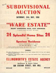 Ringwood and District Historical Society
Flyer, Subdivisional Auction Sale Brochure, Ware Estate, East Ringwood, Vic. - 1958
Folded double-sided advertisement for auction of 24 home sites and existing residence on Saturday, 24th May, 1958, including locality map, subdivision layout, terms of sale, and summary of local facilities and services. Additional plan of lots 28-33 dated 26/10/60 by Licensed Surveyor for Kirkpatrick & Webber, 225 Maroondah Highway Ringwood headed Plan of Subdivision of part of Crown Allotment 26A Parish of Ringwood.Subdivision includes Mount Dandenong Road, Ware Crescent, Davey Drive, and Grey Road (later Grey Street). Timber residence included in the subdivision was formerly Ware Kindergarten Holiday Home. (Agent) Ellingworth's Estate Agency, 580 Station Street, Box Hill - (Phone) WX1228. -
 Warrnambool and District Historical Society Inc.
Letter book 8, Letters on Hyd Engineering
This book contains letters and mathematical computations on hydraulic engineering. The material has been compiled by Arnold Lilley (Lilly), an Oxford mathematician working in Victoria in the 1890s. It is said that he taught or coached 95% of the municipal surveyors in Victoria in the 1890s. The book came from the office of one of Lilley’s pupils, John William Crawley Junior, an engineer, surveyor and architect with a private practice in Warrnambool and also the engineer for the Shire of Warrnambool from 1895 to 1935. It is presumed that he had the letters bound in book form. The book passed to his son, Rolf Crawley, the engineer for the Shire of Warrnambool from 1935 to 1968. It later came into the possession of Michael Hand who took over the private surveying business of Rolf Crawley in Warrnambool. The Warrnambool and District Historical Society acquired the book, along with other Crawley ledgers, from the estate of Michael Hand.This book is of interest as a memento of the 1890s teachings of the mathematician, Arnold Lilley and also of his pupil, John William Crawley, the engineer for the Shire of Warrnambool for 40 years.This is a blue hard-cover book containing handwritten letters and computations. There are some loose pages and some pages have postal stamps on them. The book spine is slightly scuffed. ‘Letters on Hydraulic Engineering by Arnold Lilly Esq Mathematical Coach. J. Wm. Crawley Junior Pupil’rolf crawley, warrnambool, john william crawley junior, warrnambool, shire of warrnambool, arnold lilley, mathematician and teacher -
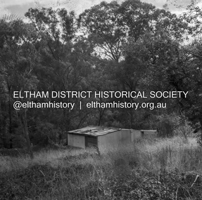 Eltham District Historical Society Inc
Negative - Photograph, J.A. McDonald, Road Reserve Housing, Mar. 1961
Shack built on road reserve without permit Most probably up on Simms Road, Kinglake Other areas where illegal shacks were built wer at the junction of Flat Rock Road and Cherry Tree Road, Hurstbridge. At times, Building Surveyor George E Newton would have to attend to these shacks for inspection and issue demolition ordersRecord of various Shire of Eltham infrastructure works undertaken during the period of 1952-1962 involving bridge and road reconstruction projects, sometimes with Eltham Shire Council Project Reference numbers quoted. It was during this period that a number of significant improvements were made to roads and new bridges constructed within the shire that remain in place as of present day (2022). In many situations, the photos provide a tangible visible record of infrastructure that existed throughout the early days of the Shire. The album was put together by or under the direction of the Shire Engineer, J.A. McDonald.infrastructure, shire of eltham, 1961-03, building surveyor, cherry tree road, flat rock road, george e. newton, houses, hurstbridge, kinglake, road reserve, road reserve housing, scan - 120 format 6x6 negative, shack, simms road -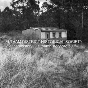
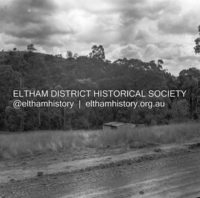 Eltham District Historical Society Inc
Negative - Photograph, J.A. McDonald, Road Reserve Housing, Mar. 1961
Shack built on road reserve without permit Most probably up on Simms Road, Kinglake Other areas where illegal shacks were built were at the junction of Flat Rock Road and Cherry Tree Road, Hurstbridge. At times, Building Surveyor George E Newton would have to attend to these shacks for inspection and issue demolition ordersRecord of various Shire of Eltham infrastructure works undertaken during the period of 1952-1962 involving bridge and road reconstruction projects, sometimes with Eltham Shire Council Project Reference numbers quoted. It was during this period that a number of significant improvements were made to roads and new bridges constructed within the shire that remain in place as of present day (2022). In many situations, the photos provide a tangible visible record of infrastructure that existed throughout the early days of the Shire. The album was put together by or under the direction of the Shire Engineer, J.A. McDonald.infrastructure, shire of eltham, 1961-03, building surveyor, cherry tree road, flat rock road, george e. newton, houses, hurstbridge, kinglake, road reserve, road reserve housing, scan - 120 format 6x6 negative, shack, simms road -
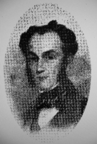 Greensborough Historical Society
Photograph - Digital image, Portrait of Edward Green, 1850c
Portrait of Edward Green. In the 1840s, Edward B. Green ran the mail service between Melbourne and Sydney and owned a parcel of land on the Plenty River. He engaged a surveyor to draw up plans and lay out a township on the slopes overlooking the river, and to mark out small farm holdings on the flats. This small township named after him is now Greensborough.Digital copy of portrait.edward bernard green, greensborough history -
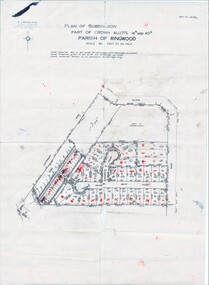
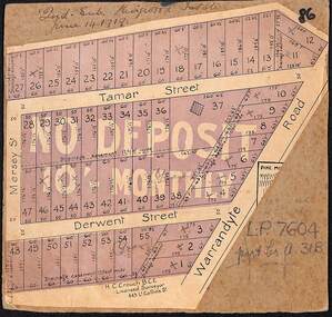 Ringwood and District Historical Society
Map, The Ringwood Estate - Second Sub-Division, Ringwood, Victoria - 1919
Three cardboard-backed copies of map clipped from land sale auction brochure. Subdivision includes Warrandyte Road, Tamar Street, Mersey Street and Derwent Street.H.C. Crouch BCE, Licensed Surveyor, 443 LtCollins Street, Melbourne. Handwritten real estate notations in margins and on some allotments include sales information and reference LP7604 - Part of Crown Allotment 31B. Auction date June 14th, 1919.