Showing 760 items
matching tennis courts.
-
 Bendigo Military Museum
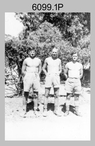
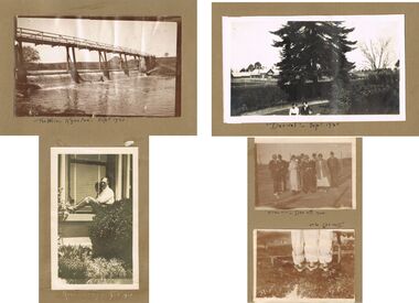
photograph - Fortuna - 1st Year of Army Occupation in Bendigo, 1942
... . Fortuna, Bendigo taken from the far side of tennis courts. .13... of tennis courts.’ .13) - Annotated on back ‘ “Fortuna” across... of tennis courts.’ .13) - Annotated on back ‘ “Fortuna” across ...This is a set of 17 photographs taken during the first year of Army occupation at Fortuna, Bendigo in 1942. The photos provide an insight into the preparatory work performed on the Fortuna Villa and surrounding buildings, by the Working Party 5th Army Troop and Ordnance Training Depot, before its occupation by personnel from LHQ Cartographic Company, Royal Australian Survey Corps. The annotation on the back of Photos .9P and .10P is misspelt. The correct spelling is ‘Nell Gwynne’. The poppet head of the Central Nell Gwynne mine is still an iconic landmark in Bendigo, lying just down the road from the poppet head lookout at Victoria Hill. The Central Nell Gwynne was the premier mine of Bendigo's 1930s mining revival and is of high historical value, due to the extensive and relatively intact features which remain at the site. The annotation on the back of Photo .17P is incorrect. The location of HQ 5th Army Troop was ‘Reynard St, Coburg.’ By late 1941 as Japan extended its control throughout Indo-China, resolving the accommodation problem of AHQ Cartographic Company located in Melbourne became more urgent. The steady Japanese advance made the bombing of Melbourne no longer a remote possibility, and in accordance with a general policy of dispersion, the Deputy Chief of the General Staff, Major General Sidney Rowell instructed Major William Sarll, in the interests of security of plant and to provide against possible damage of air attack, to investigate suitable safer inland accommodation for AHQ Cartographic Company. Major Sarll inspected many properties before finding one that would meet the requirements of the Cartographic Company. In late 1941, he came to inspect Fortuna, a rambling old mansion with about fifteen acres of ground in central Bendigo. Initially there was no intention to occupy the site beyond the end of the war, although Major Sarll's report to the Director of Survey noted many advantages in moving the Company to Bendigo. Major General Rowell quickly approved the selection of Fortuna before other authorities, which were investigating the evacuation of school children, could get in ahead of the Cartographic Company. On 23 March 1942, the Commonwealth of Australia, under the provisions of the National Security Act of 1939, took possession of the house, the old battery buildings and the fifteen acres of grounds. Under Warrant Officer J. Trist’s direction, over fifty Parks and Works tradesmen completed building works necessary to accommodate the Survey Corps’ military, map making and printing requirements. The building program was still under way when the first officer, Lieutenant Ralph Westgarth, arrived in May 1942 with the advance party which received and positioned all equipment as it came up from Melbourne in semi-trailers. Once the equipment was installed the rest of the Cartographic Company completed its shift to Bendigo by 11th June 1942. The first year of the Survey Corps’ occupation of Fortuna is covered in more detail with additional historic photographs, in pages 17-22 of Valerie Lovejoy’s book 'Mapmakers of Fortuna – A history of the Army Survey Regiment’ ISBN: 0-646-42120-4.This is a set of 17 photographs taken during the first year of Army Occupation at Fortuna, Bendigo in 1942. The black and white photographs were printed on photographic paper and are part of the Army Survey Regiment’s Collection. The photographs were scanned at 300 dpi. .1) - Photo, black & white, 1942. Bendigo Parks and Works tradesmen at Fortuna. L to R: Cliff Day, Ernie Arnold, Norm? .2) - Photo, black & white, 1942. “Don” - possibly SGT Don Sutcliffe. Fortuna, Bendigo. .3) - Photo, black & white, 1942. Parks and Works tradesmen in garden at Fortuna, Bendigo. L to R: Fred & Ernie. .4) - Photo, black & white, 1942. Benny Jack Williams at Fortuna, Bendigo. Accommodation tents were erected above the lake, which later became the parade ground. .5) - Photo, black & white, 1942. Working dress - Giggle suits. Parks and Works tradesmen at Fortuna, Bendigo. L to R: Cliff and Harry on big roof. .6) - Photo, black & white, 1942. Parks and Works tradesmen at Fortuna, Bendigo. Ted on big roof. .7) - Photo, black & white, 1942. Gold crusher battery just behind Fortuna. .8) - Photo, black & white, 1942. Scene of Bendigo from Fortuna. .9) - Photo, black & white, 1942. Nell Gwynne Mine from mullock heap at Victoria Hill near Fortuna, Bendigo. .10) - Photo, black & white, 1942. Nell Gwynne Mine and crusher near Fortuna, Bendigo. .11) - Photo, black & white, 1942. Sluicing for gold at Eaglehawk. .12) - Photo, black & white, 1942. Fortuna, Bendigo taken from the far side of tennis courts. .13) - Photo, black & white, 1942. Fortuna, Bendigo & its reflection from across the lake. .14) - Photo, black & white, 1942. Fortuna, Bendigo from the fishpond. .15) - Photo, black & white, 1942. Fortuna, Bendigo. .16) - Photo, black & white, 1942. First Fortuna Football Team at unknown location. L to R: 5th Bob Wright, 11th SGT Don Sutcliffe. .17) - Photo, black & white, 1942. Working Party from 5th Army Troop and Ordnance Training Depot at Fortuna, Bendigo.Some personnel are identified. Annotated with date within photos. .1) – Annotated on back ‘Cliff, Ernie, Norm, Dec ‘42. Cliff Day - dairy farmer, plasterers’ labourer. Ernie Arnold – hard plasterer. Norm? - QM Store for tools etc. QM Store was the Stables.’ .2) - Annotated on back ‘Don. Fortuna 1942’ .3) - Annotated on back ‘Fred & Ernie. Dec 1942. Carpenters. Note the state of the gardens.’ .4) - Annotated on back ‘Benny Jack Williams Fortuna Bendigo. Tents were erected where present day parade ground is above the lake.’ .5) - Annotated on back ‘Working dress - Giggle suits. June 42. Cliff and Harry on big roof. This photo was taken as the ventilating ridge was being installed on the building housing the printing machines. The machines were installed later by civilian labour when building was complete.’ .6) - Annotated on back ‘Ted on big roof Fortuna Bendigo.’ .7) - Annotated on back ‘Gold crusher battery – Bendigo for slay heap – 1942. 12 stamp battery. Just behind Fortuna. Was working at night when the “Army” came to Bendigo. Later removed to “Coolgardie - WA. Present site of Southern Cross TV.’ .8) - Annotated on back ‘Scene of Bendigo from Fortuna. June 1942.’ .9) - Annotated on back ‘Nell Gwyne Mine from mullock heap (Victoria Hill) Sept 1942.’ .10) - Annotated on back ‘Nell Gwyne Mine and crusher September 1942.’ .11) - Annotated on back ‘Sluicing for gold at Eaglehawk. August 1942.’ .12) - Annotated on back ‘Fortuna Bendigo 1942. Taken from far side of tennis courts.’ .13) - Annotated on back ‘ “Fortuna” across the lake & reflection.’ .14) - Annotated on back ‘Fortuna from fishpond June 1942.’ .15) - Annotated on back ‘Fortuna Dec 1942.’ .16) - Annotated on front ‘X’ x2. Annotated on back First Fortuna Football Team 1942‘Bob Wright’, ‘SGT Don Sutcliffe’. .17) - Annotated ‘Working Party at Fortuna before one of the drafts’, Working Party 5th Army Troop and Ordnance Training Depot Showgrounds, now the Sportsground Bendigo’, ‘HQ of 5th Army Troop was Reynards Rd, Coburg.’royal australian survey corps, rasvy, army survey regiment, army svy regt, fortuna, asr -
 Ringwood and District Historical Society
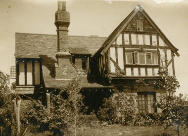
Document - Folder, Proposed Auction - Wellwood Cottage, Glenvale Road, Ringwood - 1955
... , large workshops. Childrens' 2 storey play house, tennis court..., large workshops. Childrens' 2 storey play house, tennis court ...Folder containing auction advertisements and incomplete copies of Certificate of Sale from an abortive November 1955 auction of "Wellwood Cottage" Elizabethan style residence under instructions from Keith Wellwood Storey. Newspaper auction clippings from Melbourne Age and Argus issues during November 1955 attached to folder. Packet of family photographs circa 1950s featuring exterior and interior views of the residence and grounds including 2 with captions - "... Rosemary putting food out for birds ..." and "Wellwood Cottage taken in snow in July '51 from Glenvale Road". Property description: "Elizabethan type residence in brick and timber of 2 storeys and attic, containing lounge, dining room, kitchen, living room, study, 3 bedrooms, 2 attic rooms, garage, large workshops. Childrens' 2 storey play house, tennis court, barbecues, etc. Elec. H.W.S., septic sewerage. This desirable and unique property is situated in 5 acres of land, including garden of ornamental shrubs and pine plantation. High position approximately 1-1/2 miles from Ringwood Station. Vacant Possession. Terms 10% deposit, balance 60 days. Inspection 2-4p.m. Saturdays, or by appointment with the Auctioneer, C.E. Carter & Son, 126 Whitehorse Road, Ringwood, WU6024." Accompanying handwritten sales notes researched in 2024 by Richard Carter - Carter Real Estate - "Property did not sell then, but was later sold to Bethunes. House demolished circa 2020". -
 Marysville & District Historical Society
Document (Item), Vera and Peter Gill, El Kanah Marysville (pre 2009 Fires) - More than a Guest House, Unknown
... Tennis and Volley Ball Courts which was a work for the Dole... outline of El Kanah's work when she opened the restored/ Tennis... Tennis and Volley Ball Courts which was a work for the Dole ...A document regarding El Kanah in Marysville that outlines it's purposes. This paper was compiled for The Hon. Fran Bailey as a short outline of El Kanah's work when she opened the restored Tennis and Volley Ball Courts which was a work for the Dole program nominated for a John Howard Award.A document regarding El Kanah in Marysville that outlines it's purposes.This paper was compiled for The Hon. Fran Bailey as a short outline of El Kanah's work when she opened the restored/ Tennis and Volley Ball Courts which was a work for the Dole program nominated for a John Howard Award.marysville, victoria, australia, el kanah, accommodation, christian community, 2009 black saturday bushfires -
 Bendigo Historical Society Inc.
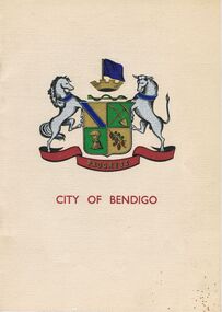
Book - JOAN O'SHEA COLLECTION: 150TH ANNIVERSARY OF BENDIGO BOOKLET, 1850 - 1950's
... Oval, Municipal Lawn Tennis Courts The Future of Bendigo... Oval, Municipal Lawn Tennis Courts The Future of Bendigo ...Joan O'Shea Collection. Buff Coloured Booklet City of Bendigo. 150th anniversary of Bendigo 1850s to 1950s. Image on cover coat of arms for City of Bendigo underneath word progress, left hand side horse, right hand side bullock. History of Bendigo: From Sheep Run to Provincial City in 100 years. Map of Bendigo and Surrounds Railways, Water Courses & Storage, Power, Municipal Boundaries & Land Available for Industry. Municipal District Creation 1855, Borough Proclamation 1863, Proclaimed City 1871, Area: 7992 Acres Population as of last census City of Bendigo 28,722, City of Bendigo and adjacent Urban Areas 36,909. City of Bendigo Map, The Past Prior to 1850. Icons of Bendigo The Bendigo base Hospital,Law Courts & Post Office, Primary Schools, Housing, Industry including Butter Production, Poultry Farming, Livestock Sales & Tomato Growing, Slaughter House & ordnance factory. The Present Recreation Photos: Bendigo Bowling Club, Queen Elizabeth Oval, Municipal Lawn Tennis Courts The Future of Bendigo, Bendigo Photographs From The 1950s,Cambridge Press Bendigobendigo, history, progress of bendigo 1850s on. -
 Eltham District Historical Society Inc
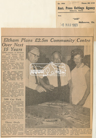
Newspaper Clipping, Eltham Plans £2.5m Community Centre Over Next 15 Years, The Age, 6 March 1963 page 7, 1963
... , as well as a 50-metre Olympic swimming pool, tennis courts..., as well as a 50-metre Olympic swimming pool, tennis courts ...Eltham Plans £2.5m Community Centre Over Next 15 Years THE people of Eltham have drawn up a plan to make their township a model community centre in the next 15 years. And yesterday the Chief Secretary (Mr Rylah) inspected the plan at the Eltham shire offices before declaring it open for public inspection In the picture (right) Mr. Rylah (centre) is shown inspecting the new plan with town planner and former councillor, Mr. Howard Bartlett, and the shire president, Cr. C. Pelling. The result of six years' work by shire officers, the plan provides for a business centre, public buildings and recreational reserves. The shire council expects that £2,500,000 will be invested by Government departments, banks, private firms and sporting bodies to implement the plan. 500 Car Park A feature of the business centre will be a quadrangle car park surrounded by shops, and with parking space for 500 cars. The public buildings will include new municipal offices, a public auditorium, a library and meeting rooms. The council plans to realign the course of Diamond Creek near the town to provide extra land for playing fields. Three Ovals The plan proposes three ovals, including improvements to an existing one, as well as a 50-metre Olympic swimming pool, tennis courts and bowling greens. In the 15 years which the shire council hopes to carry out the plan, the shire population of 18,000 is expected to increase two and a half times. Opening the display of maps and a model, Mr. Rylah said he commended the shire council's invitation to the citizens to suggest improvements to the plan. Eltham shire had grown tremendously in the past 20 years, from a sleepy country town to an important shopping centre. Digital file only of copy provided on loanauditorim, bowlong green, charis pelling, eltham community centre, rylah, howard bartlett, car park, library, forward plan -
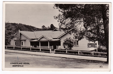 Marysville & District Historical Society
Postcard (item) - Black and white postcard, Valentine Publishing Co. Pty. Ltd, CUMBERLAND HOUSE, MARYSVILLE, 1923-1963
... the whole on the West wall of the lounge & outlooks/ the Tennis... the whole on the West wall of the lounge & outlooks/ the Tennis ...A black and white postcard of Cumberland House in Marysville. The postcard was produced by Valentine Publishing Co. Pty Ltd. as a souvenir of Marysville.A black and white postcard of Cumberland House in Marysville. The postcard was produced by Valentine Publishing Co. Pty Ltd. as a souvenir of Marysville.VALENTINE'S/ POST CARD A GENUINE PHOTOGRAPH 29.8.50 Dear Wen & Seb/ just a big Cheerio from us all up here, we/ are having a lovely time very nice here lovely fires but/ it is sure cold at night but so far we kept warm/ with over coats & rugs Weather has been lovely although/ it rained shortly after we arrived on Sunday after/ a very delightful trip up. Even had Gosling for Dinner on/ arrival Meals are very nice & Crowd very sociable/ Here in the Lounge is a big scenic Window takes/ up the whole on the West wall of the lounge & outlooks/ the Tennis Court so we are fully entertained what/ with fireside Chatter & Tennis the other way./ Very sorry I never managed to write before I left, did/ so intend but never suceeded, but will endeavour to/ make up when I return Hope alls well with you all there/ Love from Mary & allmarysville, victoria, australia, cumberland house, the cumberland guest house, accommodation, valentine publishing co pty ltd, postcard, souvenir, v.1. -
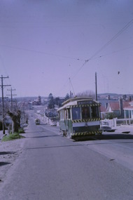
 Ballarat Tramway Museum
Slide - 35mm slide/s - set of 14, Noel Simons, 22/05/1971 12:00:00 AM
... 1170.5 - Scrubber car on "O " road with tennis court alongside... 1170.5 - Scrubber car on "O " road with tennis court alongside ...Set of 14 transparencies taken on 22/5/1971. 1170.1 - No. 31 outbound in Sturt St. West near Murray St. - has "To read pack Tilt Train" roof advert. 1170.2 - No. 31 ditto, near Russel St. loop. 1170.3 - No. 14 in Wendouree Parade at what is now BTM Depot Junction, near Toilet block. 1170.4 - No. 31 in Wendouree Parade at the North Gardens, approaching St. Aidans Drive 1170.5 - Scrubber car on "O " road with tennis court alongside. 1170.6 - Scrubber, 43 and 3 8 on 0 road at depot. 1170.7 - 3 8 and 43 on 0 road at depot 1170.8 - 38 on 0 road at depot, showing sharpness of 0 road curves. 1170.9 - 39 and 40 inside depot. 40 has "To read pack, tilt tram" roof advertisement. 1170. 10 - Tram 27 passes the depot gates, east bound with Lake Wendouree in the background. 1170.11 - SEC Depot, from Wendouree Parade, with No. 38 on "O" road. 1170.12 - trams 14 and 30 at depot loop, Wendouree Parade 1170.13 - ditto 1170.14 - "Cars take following line" sign on tram stop pole at Wendouree Parade Loop. All have date stamp of "28 Apr 1971" in purple ink on base. All blue ink unless otherwise noted. 1170.1 - "No. 31 in Sturt St. West between Murray and Wonliss Sts." 1170.2 - "No. 31 approaching Russell St. Loop in Sturt St. West Ballarat" 1170.3 - "No. 14 Gardens" 1170.4 - "No. 3 1 North Gardens 1170.5 - "Track cleaner car (formerly No. 23) at Wendouree Depot" 1170.6 - "Track cleaner, No. 43 and No. 38 at Wendouree Depot" 1170.7 - "No. 43 and No. 38 at Wendouree Depot" 1170.8 - "No. 38 gazes across Lake Wendouree from depot" 1170.9 - "Nos 3 9 and 40 in Wendouree Depot" 1170.10 - "No. 27 passing Wendouree Depot" 1170.11 - "Wendouree Depot with No. 38 on road No. "O" on left. 1170.12 - "Depot Loop" 1170.13 - "Depot Loop" 1170.14 - "Depot" tramways, trams, sturt st. west, wendouree parade, o road, depot, depot loop, signs, bliss bombs, tram 14, tram 27, tram 30, tram 31, tram 38, tram 39, tram 40, tram 43, tram scrubber -
 Kew Historical Society Inc
Plan, Melbourne & Metropolitan Board of Works. Borough of Kew Detail Plan No.1579, 1904
... of which is listed a bowling green, two tennis courts, a ‘skittle..., two tennis courts, a ‘skittle alley’ and a pavilion. When ...The Melbourne and Metropolitan Board of Works (MMBW) plans were produced from the 1890s to the 1950s. They were crucial to the design and development of Melbourne's sewerage and drainage system. The plans, at a scale of 40 feet to 1 inch (1:480), provide a detailed historical record of Melbourne streetscapes and environmental features. Each plan covers one or two street blocks (roughly six streets), showing details of buildings, including garden layouts and ownership boundaries, and features such as laneways, drains, bridges, parks, municipal boundaries and other prominent landmarks as they existed at the time each plan was produced. (Source: State Library of Victoria). This plan forms part of a large group of MMBW plans and maps that was donated to the Society by the Mr Poulter, City Engineer of the City of Kew in 1989. Within this collection, thirty-five hand-coloured plans, backed with linen, are of statewide significance as they include annotations that provide details of construction materials used in buildings in the first decade of the 20th century as well as additional information about land ownership and usage. The copies in the Public Record Office Victoria and the State Library of Victoria are monochrome versions which do not denote building materials so that the maps in this collection are invaluable and unique tools for researchers and heritage consultants. A number of the plans are not held in the collection of the State Library of Victoria so they have the additional attribute of rarity.Original survey plan, issued by the MMBW to a contractor with responsibility for constructing sewers in the area identified on the plan within the Borough of Kew. The plan was at some stage hand-coloured, possibly by the contractor, but more likely by officers working in the Engineering Department of the Borough and later Town, then City of Kew. The hand-coloured sections of buildings on the plan were used to denote masonry or brick constructions (pink), weatherboard constructions (yellow), and public buildings (grey). While MMBW Plan No.1579 does not include many buildings, those that it does show are significant to Kew’s history. These include the ‘Kew [Railway] Station’ in Denmark Street and the ‘Recreation Hall’ and rear courts off Wellington Street. The plan shows the outline of the Recreation Hall, constructed in 1880, at the rear of which is listed a bowling green, two tennis courts, a ‘skittle alley’ and a pavilion. When the Hall was first built, the Kew Cricket Club occupied an adjacent ground, however in 1885 this was acquired by the State Government as the future location of the Kew Railway Station. The Plan also shows a single oval at Xavier College. This oval was completed in 1883. One of the current ovals conforms to this oval’s original shape and position in the school grounds.melbourne and metropolitan board of works, detail plans, maps - borough of kew, mmbw 1579, cartography -
 Federation University Historical Collection
Book - Documents, Herbert Henry Smith, Ballarat Technical Art School, 1918-1929, 1918-1929
... tennis court... Boys Home, Tennis Court 22 August 1924 - Letterhead... robinson annie hauser robina mackie e. quick tennis court w.e ...Blue hard covered book with hand written reports from the Art Principal, H.H. Principal. Two letters are pasted into the front, one from Frank Tate of the Victorian Education Department. 26 April 1918 - Proposed pottery industry in Ballarat 31 May 1919 - Erection of pottery kiln, with Selkirk bricks. 28 June 1918 - Daylesford Technical Art School. 30 August 1918 - Resignation of C. Campbell, instructor of Photography. 25 October 1918 - Returned Soldiers Classes in Art Metal and Signwriting. 25 October 1918 - Herald Shield Trophy 28 July 1922 - Ragged Boys Home, Tennis Court 22 August 1924 - Letterhead of the Attorney General Victoria concerning the transfer of the Ballarat Supreme Court to the Ballarat School of Mines. 15 October 1924 and 20 May 1925 - Carvings of 24 panels decorated with Australian birds, animals and flora to form part of the decoratve scheme for the Villers Bretonneux school. 21 April 1926 - White Flat is available for the use of the school. 29 February 1928 - Donation of a linotype machine by The Courier. 27 June 1928 - Internal Sewerage to the Ballarat Technical Art Schoolballarat school of mines, ballarat technical art school, h.h. smith, returned soldier teachers, harold herbert, ponsonby carew-smyth, f.h. hoskin, carpentry workshop, donald i. johnston, herald shield, kenneth moss, hilda wardle, miss bell, margaret bell, millinery, j.y. mcdonald soldiers memorial, john rowell, repatriation building, stained glass classes, dressmaking fees, ballarat supreme court, m. baird, carvings, villers bretonneux school carvings, ethel kift, m.c. young, macrobertson scholarship, elvie ford, edwin robinson, annie hauser, robina mackie, e. quick, tennis court, w.e. gower, colin hunt, white flat, frank hall, effie holmes, mavis beacham, henry harvey, plaster casts, pearl frickie, w.r. dean, marjery henderson, sewerage, laura crouch, ballarat teachers' college, gertie gough, gwen nagle, lynda clark, jack walker, cyril gibbs, repatriation, donald johnston, ceramics, kiln, c. campbell, photography, jean maude, sylvia copperwaite, olga dulfer, may pollock, margaret bailey, stella clarkson, may norrie, nellie nicholls, nancy govan, edith curnow, kathleen windsor, betty johnson, edna pearson, elvie thege, gwen neagle, effie george, gwen tunbridge -
 Southern Sherbrooke Historical Society Inc.
Photograph - Bert and Minnie Sutton c.mid 1940s
... " (with an arrow pointing right) and "Central Park Tennis Courts..." (with an arrow pointing right) and "Central Park Tennis Courts ...B&W photo of Bert (Gilbert William) and Minnie (Williamina Wilson) Sutton (daughter of Charles Macauley and Minnie Gray) standing outside their original home in Belgrave Heights. The photo shows the couple standing at their post-and-wire front fence at their property in Lockwood Road. The house was next door to Edward's store. Bert is in shirtsleeves and Minnie is wearing a cardigan over a dress. Their house is a single gabled house of weatherboard and fibro sheeting with an L-shaped open verandah. After purchasing the house Bert altered it, eventually enclosing the verandah and turning it into a sleepout. The house has been extensively altered since but is still standing in Lockwood Rd. The block is treed and the garden appears to be rather wild. A tiled roofed building is behind the house and to the left, possibly a garage. On the nature strip in front of the Suttons' house is a wooden bench, and attached to a tree are the signs, "Lockwood House" (with a hand pointing right), "To golf links" (with an arrow pointing right) and "Central Park Tennis Courts" (with an arrow pointing left). The sun is shining. Bert, who was a carpenter, died in 1969 and Minnie died in 1977. Copy of original photo donated to our society by Kath Oram, a founding member. -
 Glenelg Shire Council Cultural Collection
Photograph - Photograph - Portland Tennis Club, n.d
... . Woman holding tennis racquet standing on court at Portland... racquet standing on court at Portland Tennis Club (Gardens). Man ...Black and white photograph taken from glass plate negative. Woman holding tennis racquet standing on court at Portland Tennis Club (Gardens). Man standing on court behind her. Estimated dress late 19th, early 20th Century. -
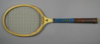 Tennis Australia
Racquet, Circa 1960
... A Court King tennis racquet, with hide shoulder... Park Melbourne melbourne Tennis A Court King tennis racquet ...A Court King tennis racquet, with hide shoulder reinforcements, string whipping around shoulders and shaft, and leather handle with floral perforations. Materials: Wood, Ink, Glue, Lacquer, Metal, Enamel, Leather, Cloth, String, Adhesive tape, Fibre, Hide, Nylontennis -
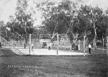 Eltham District Historical Society Inc
Negative - Photograph, J.H. Clark, Eltham Tennis Court, c.1905
... Eltham Tennis Court...eltham tennis court...People pose for a photograph at the Eltham tennis court... melbourne People pose for a photograph at the Eltham tennis court ...People pose for a photograph at the Eltham tennis court. Four men set to play a doubles match while a group of women look on. The sandy looking court (with weeds growing) is surrounded by wooden posts with wire mesh, in the middle of a park with mature gum trees in the background. The tennis court was situated in Eltham South at Bremner’s Flats (near present day Wingrove Park). The court is approximately the location of the present day small carpark. Main Road can be seen in the background from centre left and Mount Pleasant just above, the intersection just above the centre of court. The photo by J.H. Clark has been taken outside the court. Cross Ref SEPP_0721 of the Lady Premiers for 1909-1910 in which an umpires raised seating platform has been erected and the court surface is more refined with marked lines. The Eltham Lawn Tennis Club was formed on a Saturday evening, the 29th of October, 1898 at a meeting held at the Eltham State school. The meeting was large and representative. Twenty members were enrolled, and eight more have since been added. Officers and a committee were duly elected, and the Treasurer was instructed to purchase the necessary requisites without delay. By the end of the first week in November all the requisites were to hand, two courts were marked out, and practice begun. The formal opening of the Courts of this Club took place on Saturday, November 12, 1898, when 26 members and their friends assembled. After several sets had been contested an adjournment was made for tea provided by the members and nicely laid out under the shade of the trees. Afterwards, sets were again formed and the game was proceeded with in a lively spirit till nearly dark, when all dispersed having thoroughly enjoyed themselves during the afternoon. (Evelyn Observer, and South and East Bourke Record (Vic. : 1882 - 1902), Friday 18 November 1898, page 2) Reproduced on p89 of 'Pioneers & Painters' Photographer: J.H. Clark John Henry Clark was the youngest of three boys born to William Henry Clark (1823-1877) and Maria White (1843-1914). He and his brothers, William Charles Clark (1872-1945), Clement Kent Clark (1874-1912) operated a photography business (Clark Bros.) from 25 Thomas Street, Windsor near Prahran during the period c.1894 to 1914. Following death of Clement in September 1912 and their mother in 1914, the Clark Bros business appears to have dissolved, the premises demolished, and a new house was under construction in 1915. John set up business independently in 1914 operating out of 29 Moor Street, Fitzroy where he is registered in the 1914 and 1915 Electoral Rolls. By 1916 John had relocated to Eltham where he continued his practice as a photographer and took many of the early images around the district of Little Eltham. Around 1930 John changed professions and opened a small cobbler's shop in 1931 near the pond opposite Dalton Street adjacent to the Jarrold family cottage. He never married and continued his profession as a bootmaker from this little shop, maintaining a close relationship with Mrs Jarrold for the rest of their lives. His bootmaker shop remains today beside the Whitecloud cottage and is one of only three remaining shops in the area from the early 20th century. There are a couple of images of Eltham taken by Clark Bros. in the Eltham District Historical Society collection, one such example being Hunniford’s Post Office with Miss Anne Hunniford out front (EDHS_00140 - marked on the back of the print, Clark Bros., 25 Thomas St. Windsor), which would date this image between c.1894 and 1914. Other early images of Eltham taken by John Henry Clark are marked on the face “J. H. Clark Photo” and it is assumed these are dated between 1914 and 1930. It is noted that the Grant of Probate for John H Clark of Eltham South dated 5 April !957 (513/387) records his occupation as "X Photographer".This photo forms part of a collection of photographs gathered by the Shire of Eltham for their centenary project book,"Pioneers and Painters: 100 years of the Shire of Eltham" by Alan Marshall (1971). The collection of over 500 images is held in partnership between Eltham District Historical Society and Yarra Plenty Regional Library (Eltham Library) and is now formally known as the 'The Shire of Eltham Pioneers Photograph Collection.' It is significant in being the first community sourced collection representing the places and people of the Shire's first one hundred years.Digital image 4 x 5 inch B&W Negshire of eltham pioneers photograph collection, bremner's flat, eltham, eltham tennis court, j.h. clark photo, pioneers and painters, tennis court, wingrove park, 1905, eltham lawn tennis club, main road, mount pleasant road -
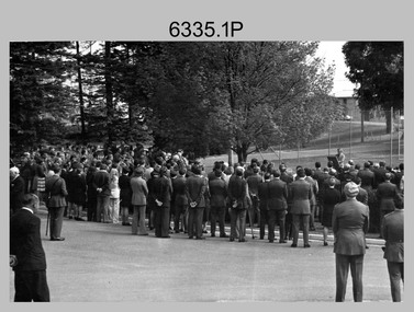 Bendigo Military Museum
Photograph - Military Funeral for SSGT Peter Dew, Army Survey Regiment, Fortuna, Bendigo, 1977
... of the tennis court gates: John McCulloch. Remainder unidentified. .3.... .2) - Photo, black & white, 1977. In front of the tennis ...This is a set of five black & white photographs of troops from the Army Headquarters Survey Regiment undertaking ceremonial drill at the military funeral for SSGT Peter Dew in 1977. The location of the funeral service was at Fortuna, Bendigo. He was buried at Bendigo Cemetery in Quarry Hill. Peter Dew died in a tragic accident at home. He was fondly remembered as one of Lithographic Squadron’s colourful personalities. See item 6243.7P for photos of Peter Dew at work in Lithographic Squadron. The "Super Animal of the Year" Peter Dew Memorial Award was an award presented to a member of the squadron for a crude act. To view a photo of this award, refer to item 6230 of the Victorian Collections. This is a set of five black & white photographs of troops from the Army Headquarters Survey Regiment undertaking ceremonial drill at the military funeral for SSGT Peter Dew in 1977. The photographs were printed on photographic paper and are part of the Army Survey Regiment’s Collection. The photographs were scanned at 300 dpi. .1) - Photo, black & white, 1977. Unidentified soldiers and civilians. .2) - Photo, black & white, 1977. In front of the tennis court gates: John McCulloch. Remainder unidentified. .3) - Photo, black & white, 1977. Rifle party rear rank right marker: Russ Mollenhauer. Front rank rifle party commander next to right marker: Greg Kidman. Pall bearers in front of vehicle L to R: Dave Miles, Dick Barwald. Remainder unidentified. .4) - Photo, black & white, 1977. Rifle party commander: Greg Kidman. Right file front to back: Russ Mollenhauer, Peter Breukel, Bill Jones, John Anderson. Remainder unidentified. Left file front to back: unidentified (x2), Rhys De Laine, Frank Lenane, Josh Degroot, Gary Drummond. .5) - Photo, black & white, 1977. Left of minister: Alan Toogood. On right of tree L to R: Max Neil, Bob Hayden, Dave Malligan, Le-Anne (Smallshaw) Shirley, Stan Vote. Remainder unidentified.No personnel are identified.royal australian survey corps, rasvy, army survey regiment, army svy regt, fortuna, asr -
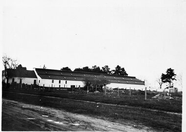 Ballarat Tramway Museum
Photograph - B&W print of donated negative - set of 5, State Electricity Commission of Victoria (SECV), c1936
... the tennis court. 1350.5 - Office, lockers etc. buildings on east... Parade - shows yard on side which was to become the tennis court ...Yields information about the depot and environs during the reconstruction of the Ballarat tramways and the vacant land to the west of the depotSet of 5 Black and white photo prints from collected negatives of the SEC Ballarat depot building, during refurbishment by the SEC during the mid 1935/1936, taken at the same time as Reg Item 1349. 1350.1 - Depot buildings from Gregory St. on the western side. Shows the whole length of the buildings. 1350.2 - Western side of depot buildings from Gregory St. end, looking towards Wendouree Parade. 1350.3 - Eastern side of depot building from Gregory St. end. 1350.4 - Western side of depot building from Wendouree Parade - shows yard on side which was to become the tennis court. 1350.5 - Office, lockers etc. buildings on east side of depot, from Wendouree Parade, Shows the 'Bundy' clock. A motor bike is parked against the wall. 2nd copy held of 1350.1, 1350.2 and 1350.3 - ex moveable display boards. Colour photocopies laminated of these photographs on display 6/2000 at 02-02-06. Copy 3 - of all above photos - large format prints (203H x 253W) - added 28/7/2007, ex Alan Bradley holding of prints, received 5/2007. See also Reg Item 3902 for a mounted set of these photographs along with that of Reg Item. 1349. High res scans of negatives changed over 13/5/2020.tramways, trams, wendouree parade, sec depot, rehabilitation, depot offices -
 Ballarat Tramway Museum
Photograph - Digital image Set of 10, Tony Smith, 5/09/1971 12:00:00 AM
... on the street. .8 - Scrubber tram on 0 road with tennis court alongside... tram on 0 road with tennis court alongside. .9 - 40 running ...Yields information about Ballarat Tramways and trams prior to the closure of the tramway system.Set of 10 digital images of Ballarat trams prior to closure, scanned from original slides by Tony Smith, 1971 prior to closure of the system. This set of slides, possibly on the last weekend of Mt Pleasant services - closure took place on 5/9/1971. .1 - 13 outbound in Barkly St, Mt Pleasant - with another single trucker and the Ballarat Fire Station in the background. .2 - Bogie tram and single trucker at Grant St Loop. Has the Mobile service station on the right hand side. Note the family sitting on the steps of a house on the left side watching proceedings. .3 - 14 (Mt Pleasant) and 39 ditto. .4 - 27? and 39 crossing at the Morrison St loop. .5 - 14 and another single trucker at Mt Pleasant terminus. Has the corner store in the background with adverts for Robur Tea, Womens Weekly and Coca Cola. .6 - 39 and two single truckers at the Mt Pleasant terminus. .7 - View looking south along Ripon St from Mair St, with power station buildings on the right hand side. Shows the power distribution poles on the street. .8 - Scrubber tram on 0 road with tennis court alongside. .9 - 40 running special in Wendouree Parade, near the Haddon St intersection. .10 - 40 turning from Macarthur St into Drummond St Nth.trams, tramways, mt pleasant, barkly st, grant st, victoria park, sturt st west, ripon st, view st, depot, wendouree parade, drummond st nth, macarthur st, closure, tram 14, tram 39, tram 13, tram 26, tram scrubber, 40 -
 Kew Historical Society Inc
Plan, Melbourne & Metropolitan Board of Works : Borough of Kew : Detail Plan No.1573, 1905
... Ladies’ College (MLC), include the school’s tennis court... tennis court and swimming pool, but are not coloured to show ...The Melbourne and Metropolitan Board of Works (MMBW) plans were produced from the 1890s to the 1950s. They were crucial to the design and development of Melbourne's sewerage and drainage system. The plans, at a scale of 40 feet to 1 inch (1:480), provide a detailed historical record of Melbourne streetscapes and environmental features. Each plan covers one or two street blocks (roughly six streets), showing details of buildings, including garden layouts and ownership boundaries, and features such as laneways, drains, bridges, parks, municipal boundaries and other prominent landmarks as they existed at the time each plan was produced. (Source: State Library of Victoria)This plan forms part of a large group of MMBW plans and maps that was donated to the Society by the Mr Poulter, City Engineer of the City of Kew in 1989. Within this collection, thirty-five hand-coloured plans, backed with linen, are of statewide significance as they include annotations that provide details of construction materials used in buildings in the first decade of the 20th century as well as additional information about land ownership and usage. The copies in the Public Record Office Victoria and the State Library of Victoria are monochrome versions which do not denote building materials so that the maps in this collection are invaluable and unique tools for researchers and heritage consultants. A number of the plans are not held in the collection of the State Library of Victoria so they have the additional attribute of rarity.Original survey plan, issued by the MMBW to a contractor with responsibility for constructing sewers in the area identified on the plan within the Borough of Kew. The plan was at some stage hand-coloured, possibly by the contractor, but more likely by officers working in the Engineering Department of the Borough and later Town, then City of Kew. The hand-coloured sections of buildings on the plan were used to denote masonry or brick constructions (pink), weatherboard constructions (yellow), and public buildings (grey). This plan has detailed annotations written in red or blue ink, showing prices, which may be the annual valuations of the properties, and some owners’ names, a most unusual feature on contractor's maps. Some areas, such as the buildings of Methodist Ladies’ College (MLC), include the school’s tennis court and swimming pool, but are not coloured to show building materials – did the draftsman just run out of time, or ink, or enthusiasm, before his plan had to be submitted? MLC had been founded in 1882 as a ‘modern school of the first order’ with buildings that formed ‘a collegiate institution for girls unsurpassed in the colonies’. The goal of its founders was to provide a high-class Christian education for girls, comparable with that provided elsewhere for boys. Some shops are shown along Edgevale Road, though they are not designated as commercial premises. Larger houses are depicted, including ‘Fairlawn’ in Barkers Road, and ‘Clevedon’ and ‘Rosehill’ (now demolished) in Fitzwilliam Street.melbourne and metropolitan board of works, detail plans, mmbw 1573, maps - borough of kew, cartography -
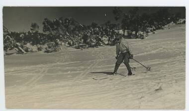 Falls Creek Historical Society
Photograph - John Meyer near Wilkie and Basalt Hill
... was a champion skier, constructing a ski-jump and a grass tennis court... a ski-jump and a grass tennis court near the hut during his ...MEYER COLLECTION - FALLS CREEK PHOTOS In 1947 a determined group of like-minded State Electricity Commission (SEC) staff including Ray Meyer, the chief surveyor of the Kiewa Hydro-Electric Scheme, had a common interest that revolved around the skiing potential of the snow-covered high plains which included what is now the resort of Falls Creek. The six SEC employees, Toni St Elmo, Ray Meyer, Jack Minogue, Lloyd Dunn, Adrian Ruffenacht and Dave Gibson (together with their families) banded together to secretly build a 'hut' that was the first ski lodge at Falls Creek. Using a road built in 1930s to gain access to Falls Creek, their hut project was carried out in secret as efforts by other skiers were blocked by H.H.C. Williams – the engineer in charge of the Hydro Scheme. In 1946 Ray Meyer made a trip to the Lands Office in Melbourne. He came away with a 99-year lease on three acres that was ideally suited for a hut designed by Lloyd Dunn. Adrian Ruffenacht (Design Engineer for the KHS) had suggested where the group should build because of easy access to a spring for water. Much of the building material required was scavenged from derelict huts on the high plains. Due to the need for secrecy, the determined group worked on the hut in the evenings and weekends to avoid detection. During the building period the group had met at Echidna Rock (now known as Eagle Rock) where Skippy St Elmo announced, "This is my favourite ‘Skyline’.” And so the first lodge in the area at Falls Creek Ski Resort came into existence. With the development of the International Poma in the 1970s, the Skyline Lodge, which was sited between the ski-lift’s pole one and pole two, was demolished. However, the legacy of Ray Meyer, Toni St Elmo, Jack Minogue, Lloyd Dunn, Adrian Ruffenacht and Dave Gibson and Skyline lives on in the vibrant atmosphere of Falls Creek Resort. The MEYER COLLECTION documents developments on the Kiewa Hydro Scheme and their life at Falls Creek from the mid 1930s to 1960s.These images are significant because they depict aspects of the life of a pioneering family of Falls Creek and the founders of "Skyline", the first lodge at Falls Creek.Two black and white images of John Meyer skiing near Wilkie and Basalt Hill, Bogong High Plains. Wilkinson’s Hut (Wilkie) was built for the SEC in the summer of 1932-3 to accommodate the snow research program manager. The cottage was sited next to a hydro-meteorological station, set on stilts above the snow. It was not a refuge hut but a permanent residence for all of the year. The work carried out there included operation of a meteorological station at the cottage, measuring the snow depth and density along two pole lines, and operating stream gauging stations in the area. The engineers stationed there included Adrian Rufenacht (1934-6), and Norwegian Martin Romuld (1936-42) Romuld was a champion skier, constructing a ski-jump and a grass tennis court near the hut during his residency. Adrian was one of the founders of 'Skyline". The hut was sold in 1948 to the Victorian Ski Club and renamed Wilkinson Lodge. Robert Wood Wilkinson, best known as 'Wilkie, was the 'Father figure' of Victorian skiing. Robert Wood Wilkinson died on May 22, 1939. The hut was resold some 12 years later to the Melbourne Bushwalkers club. In 1983, the National Parks Service described the building as an old SEC hut which had been purchased and, afterwards, maintained and occupied solely by the Melbourne Bushwalking Club. Wilkie Hut survived the 2003 bushfires but burnt down one year later (January 2004) in a cooking accident.falls creek, ray meyer, skyline -
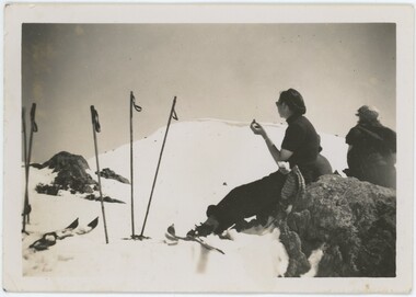 Falls Creek Historical Society
Photograph - Joan Meyer at Bogong High Plains
... was a champion skier, constructing a ski-jump and a grass tennis court... was a champion skier, constructing a ski-jump and a grass tennis court ...MEYER COLLECTION - FALLS CREEK PHOTOS In 1947 a determined group of like-minded State Electricity Commission (SEC) staff including Ray Meyer, the chief surveyor of the Kiewa Hydro-Electric Scheme, had a common interest that revolved around the skiing potential of the snow-covered high plains which included what is now the resort of Falls Creek. The six SEC employees, Toni St Elmo, Ray Meyer, Jack Minogue, Lloyd Dunn, Adrian Ruffenacht and Dave Gibson (together with their families) banded together to secretly build a 'hut' that was the first ski lodge at Falls Creek. Using a road built in 1930s to gain access to Falls Creek, their hut project was carried out in secret as efforts by other skiers were blocked by H.H.C. Williams – the engineer in charge of the Hydro Scheme. In 1946 Ray Meyer made a trip to the Lands Office in Melbourne. He came away with a 99-year lease on three acres that was ideally suited for a hut designed by Lloyd Dunn. Adrian Ruffenacht (Design Engineer for the KHS) had suggested where the group should build because of easy access to a spring for water. Much of the building material required was scavenged from derelict huts on the high plains. Due to the need for secrecy, the determined group worked on the hut in the evenings and weekends to avoid detection. During the building period the group had met at Echidna Rock (now known as Eagle Rock) where Skippy St Elmo announced, "This is my favourite ‘Skyline’.” And so the first lodge in the area at Falls Creek Ski Resort came into existence. With the development of the International Poma in the 1970s, the Skyline Lodge, which was sited between the ski-lift’s pole one and pole two, was demolished. However, the legacy of Ray Meyer, Toni St Elmo, Jack Minogue, Lloyd Dunn, Adrian Ruffenacht and Dave Gibson and Skyline lives on in the vibrant atmosphere of Falls Creek Resort. The MEYER COLLECTION documents developments on the Kiewa Hydro Scheme and their life at Falls Creek from the mid 1930s to 1960s.These images are significant because they depict aspects of the life of a pioneering family of Falls Creek and the founders of "Skyline", the first lodge at Falls Creek.Two black and white images of John Meyer skiing near Wilkie and Basalt Hill, Bogong High Plains. Wilkinson’s Hut (Wilkie) was built for the SEC in the summer of 1932-3 to accommodate the snow research program manager. The cottage was sited next to a hydro-meteorological station, set on stilts above the snow. It was not a refuge hut but a permanent residence for all of the year. The work carried out there included operation of a meteorological station at the cottage, measuring the snow depth and density along two pole lines, and operating stream gauging stations in the area. The engineers stationed there included Adrian Rufenacht (1934-6), and Norwegian Martin Romuld (1936-42) Romuld was a champion skier, constructing a ski-jump and a grass tennis court near the hut during his residency. Adrian was one of the founders of 'Skyline". The hut was sold in 1948 to the Victorian Ski Club and renamed Wilkinson Lodge. Robert Wood Wilkinson, best known as 'Wilkie, was the 'Father figure' of Victorian skiing. Robert Wood Wilkinson died on May 22, 1939. The hut was resold some 12 years later to the Melbourne Bushwalkers club. In 1983, the National Parks Service described the building as an old SEC hut which had been purchased and, afterwards, maintained and occupied solely by the Melbourne Bushwalking Club. Wilkie Hut survived the 2003 bushfires but burnt down one year later (January 2004) in a cooking accident.falls creek, joan meyer, bogong high plains -
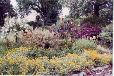 University of Melbourne, Burnley Campus Archives
Album - Colour prints, Stuart Miller, Garden Views, 1983
... tennis court... and beyond from roof of Admin Building. (5) Rear of Burnley. Tennis... bull paddock dairy tennis court shady walk luffmann ponds oak ...Colour photographs. (1) Herbaceous Border 1984-5 (pre-Rainforest) #277. (2) View Admin Building from between Emily Gibson Beds. (3) Admin Building. (4) View of Bull Paddock, Dairy and beyond from roof of Admin Building. (5) Rear of Burnley. Tennis Court replaced by PSL 4-6 (DA) (6) Shady Walk Mondograss (Ophiopogon japonicus) Umbrella Grass (Cyperus alternifolius) (David Aldous). (7) Admin Building and Student Amenities Building. (8-10) Luffmann Ponds. (11) Frank's/Rock Point. (12-13) Oak Lawn. (14) Oak Tree lawn on reverse "Please return to Stuart Miller, Burnley College." (15) E. cladocalyx. (16) The Victorian College of Agriculture & Horticulture-Burnley Campus. U. procera to the left E. cladocalyx to the right DA. (17) Sugar Gum E. cladocalyx Burnley Gardens 1989 DA. (18) Burnley College in background DA Crack Willow in winter. (19) Tree unidentified. DA (20) DA View of trees behind Luffmann Ponds. (21) View of Burnley Gardens Pinus canariensis to the left Agathis robusta centre and sequoia sempervirens to the right DA. (22) Students in Citriodora Courtyard. (23) View of Emily Gibson Beds from roof of Admin Building. (24) Admin Building from Oak lawn. Annotated by David Aldous and Stuart Miller. herbaceous border, administration building, emily gibson beds, bull paddock, dairy, tennis court, shady walk, luffmann ponds, oak lawn, david aldous, stuart miller, student amenities building, sugar gum, citriodora courtyard, lily ponds -
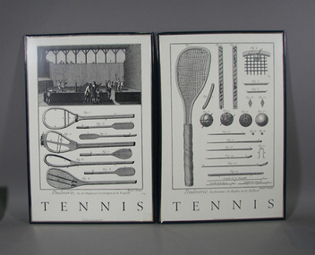 Tennis Australia
Poster, Circa 2000, 17th Century
... ) features image of court tennis and below specifications for eight... entitled 'TENNIS'; (.1) features image of court tennis and below ...Two part object: two framed monochrome posters, reproductions of 17th Century prints, both entitled 'TENNIS'; (.1) features image of court tennis and below specifications for eight paddles and early racquets. (.2) features drawings and specifications for balls, racquets, racquet strings, poles and ground stakes. Both parts framed in blue plastic frames. Materials: Ink, Paper, Metal, Cardboard, Woodtennis -
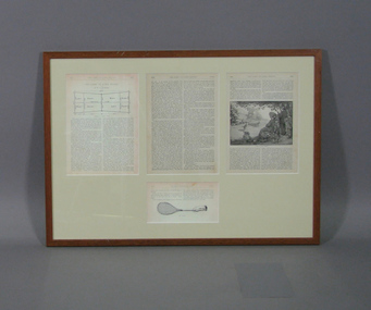 Tennis Australia
Page from Magazine, 1879
... 'THE GAME OF LAWN TENNIS'. Includes illustrations of court layout... illustrations of court layout, a racquet and tennis match scene. UV ...Four pages (reproductions of pages 655 and 658, original pages 656 and 657) from unknown magazine article entitled 'THE GAME OF LAWN TENNIS'. Includes illustrations of court layout, a racquet and tennis match scene. UV glass. Materials: Paper, Ink, Glass, Cardboard, Glue, Woodtennis -
 Kew Historical Society Inc
Plan, Melbourne & Metropolitan Board of Works : Borough of Kew : Detail Plan No.1585, 1904
... , the grounds of Ramornie included a large tennis court fronting..., the grounds of Ramornie included a large tennis court fronting ...The Melbourne and Metropolitan Board of Works (MMBW) plans were produced from the 1890s to the 1950s. They were crucial to the design and development of Melbourne's sewerage and drainage system. The plans, at a scale of 40 feet to 1 inch (1:480), provide a detailed historical record of Melbourne streetscapes and environmental features. Each plan covers one or two street blocks (roughly six streets), showing details of buildings, including garden layouts and ownership boundaries, and features such as laneways, drains, bridges, parks, municipal boundaries and other prominent landmarks as they existed at the time each plan was produced. (Source: State Library of Victoria)This plan forms part of a large group of MMBW plans and maps that was donated to the Society by the Mr Poulter, City Engineer of the City of Kew in 1989. Within this collection, thirty-five hand-coloured plans, backed with linen, are of statewide significance as they include annotations that provide details of construction materials used in buildings in the first decade of the 20th century as well as additional information about land ownership and usage. The copies in the Public Record Office Victoria and the State Library of Victoria are monochrome versions which do not denote building materials so that the maps in this collection are invaluable and unique tools for researchers and heritage consultants. A number of the plans are not held in the collection of the State Library of Victoria so they have the additional attribute of rarity.Original survey plan, issued by the MMBW to a contractor with responsibility for constructing sewers in the area identified on the plan within the Borough of Kew. The plan was at some stage hand-coloured, possibly by the contractor, but more likely by officers working in the Engineering Department of the Borough and later Town, then City of Kew. The hand-coloured sections of buildings on the plan were used to denote masonry or brick constructions (pink), weatherboard constructions (yellow), and public buildings (grey). This plan, which covers parts of High Street, Pakington Street and Derby Street is dominated by two historic Kew mansions: ‘Konetta’ and ‘Ramornie’. Ramornie was constructed in 1890 for James Maitland Campbell, three times Mayor of Kew. Sold in 1940, it became a boarding house known as ‘The Towers’. Now a private residence again, it has only one of its three balconies remaining. The location of the missing two balconies can be seen on the plan. In 1903, the grounds of Ramornie included a large tennis court fronting Pakington Street. The rear of the property is shown as extending to Cobden Street. One of Kew’s oldest hotels, the Prospect Hill Hotel on the corner of High and Cobden Street was established in 1858. The outline of the hotel shown on the plan represents the second building on the site. During the 19th century it was often used for electoral meetings. The Prospect Hill Hotel was to be redeveloped again in 1928, by the local architect Robert McIntyre. Since the 1980s, the hotel has been a live music venue, the home of the Melbourne Jazz Club, a restaurant and a liquor outlet.melbourne and metropolitan board of works, detail plans, maps - borough of kew, mmbw 1585, cartography -
 Kew Historical Society Inc
Plan, Melbourne & Metropolitan Board of Works : Borough of Kew : Detail Plan No.1563, 1905
... ’), the last being particularly impressive in 1903, with a tennis court... particularly impressive in 1903, with a tennis court, conservatory ...The Melbourne and Metropolitan Board of Works (MMBW) plans were produced from the 1890s to the 1950s. They were crucial to the design and development of Melbourne's sewerage and drainage system. The plans, at a scale of 40 feet to 1 inch (1:480), provide a detailed historical record of Melbourne streetscapes and environmental features. Each plan covers one or two street blocks (roughly six streets), showing details of buildings, including garden layouts and ownership boundaries, and features such as laneways, drains, bridges, parks, municipal boundaries and other prominent landmarks as they existed at the time each plan was produced. (Source: State Library of Victoria)This plan forms part of a large group of MMBW plans and maps that was donated to the Society by the Mr Poulter, City Engineer of the City of Kew in 1989. Within this collection, thirty-five hand-coloured plans, backed with linen, are of statewide significance as they include annotations that provide details of construction materials used in buildings in the first decade of the 20th century as well as additional information about land ownership and usage. The copies in the Public Record Office Victoria and the State Library of Victoria are monochrome versions which do not denote building materials so that the maps in this collection are invaluable and unique tools for researchers and heritage consultants. A number of the plans are not held in the collection of the State Library of Victoria so they have the additional attribute of rarity.Original survey plan, issued by the MMBW to a contractor with responsibility for constructing sewers in the area identified on the plan within the Borough of Kew. The plan was at some stage hand-coloured, possibly by the contractor, but more likely by officers working in the Engineering Department of the Borough and later Town, then City of Kew. The hand-coloured sections of buildings on the plan were used to denote masonry or brick constructions (pink), weatherboard constructions (yellow), and public buildings (grey). This plan covers the area between Barkers Road, Wrixon Street, Sackville Street and Brougham Place, much of it now occupied by Carey Baptist Grammar and Preshil schools. This was an area of large and prestigious homes in 1903, some with formally laid-out gardens, such as ‘Tower Hill’ and ‘Opawa’. ‘Kalimna’ was built in 1890-91 for William H. Jarman, an accountant, and ‘Blackhall’ at the same time for W.H. Roberts. Blackhall was to be acquired by the Salvation Army in 1915 and renamed ‘Catherine Booth Girls’ Home’. The Home accommodated girls, aged between 4 and 16. Kalimna and Blackhall are of significance as typical and intact late Victorian mansions and as such are two key Victorian buildings to have been built in Kew. Both Blackhall and Kalimna are now part of Preshil. ‘Fairview’ was for a long time occupied by the Sisters of St. Joseph of Cluny as a care home for the elderly, but it is now part of Carey Grammar School, as are the grounds of ‘Wagga Merne’, ‘Weemutta’, ‘Blakely’, ‘Daheim’ and ‘Mildura’ (later ‘Urangeline’), the last being particularly impressive in 1903, with a tennis court, conservatory, outhouses, and two bathrooms!melbourne and metropolitan board of works, detail plans, mmbw 1563, cartography -
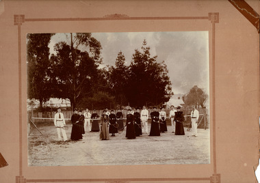 Beaufort Historical Society
Photograph - Beaufort Tennis Club
... Tennis club established 1890. Courts at Willoby Street...Tennis club established 1890. Courts at Willoby Street ...Tennis club established 1890. Courts at Willoby Street ( currently site of Council depot). Persons identified: ( L to R) Charles Troy, Violet Troy, F Minchin, A Tromph, Miss McRae, Mrs Sinclair, J McKeich, Miss N Troy, Mrs Welsh, Miss Martha Nickells, ?, Miss E Nickells, Fred Troy, Miss Jackson, Miss Jackson, B Thompson, Miss Stewart, Robert SinclairEarly sporting club in BeaufortBlack & White photograph mounted on cardNilbeaufort, beafort tennis club -
Tennis Australia
Trophy, 1949
... and District Hard Court Tennis Association for winning A2 Singles... to Lew Hoad by Balmain and District Hard Court Tennis Association ...Small silver cup trophy awarded to Lew Hoad by Balmain and District Hard Court Tennis Association for winning A2 Singles at the Annual Championships 1949. A sticky note inside the cup states 'reportedly the first trophy won by Hoad'. Marked 'EPNSA1' which is the highest grade of silver plating possible (EPNS = Electroplated Nickel Silver and A1 = the thickness of the silver plating which is usually 30 - 35 Microns). Materials: Electroplated Nickel Silver/Metaltennis -
 Kiewa Valley Historical Society
Coloured photographs on paper - Back to Tawonga 2010
... . The Kiewa Valley Road at Tawonga. Vic. 29. Tennis Courts opposite.... The Kiewa Valley Road at Tawonga. Vic. 29. Tennis Courts opposite ...These photos were collected and copied by Di Edmondson for the 'Back To Tawonga' Event in 2010 when she launched her book "Tawonga Remembers".An historical photographic collection of Tawonga and its surrounds, places and people up to 20101. Saw Mill - Mill house 2. The Rock Pool 3. People at the Rock Pool x 2 4.Old Saw mill 5. Back to Tawonga Celebrations x6 6. Tennis Curts opposite the Tawonga Store, Bakery in the background 7. Bowling Club 8. Old Guide Hall 9. The Old Boarding House 10. Old Fire Brigade Shed 11. Building the New Tawonga Memorial Hall 12. Tawonga Go Kart Track - 1960s 13. Tawonga Pony Club 1969 State Championships 14. Tawonga Recreation Reserve Newspaper article 15. The Damm Children 19. 1980s Brian Edmondson, Geoff Edmondson, Mick Harvey, David Piera. Geoff Edmondson's car 20. Tawonga Speedway Track - 1970s Mick Harvey and Paul Harkin's car 21. 2000 22. Tawonga Sports Vera Ryder and Allie Briggs 23. Tawonga School Photos x8 24. Harry Cooper's Farm Looking South 25.View from Edmondson's Farm - looking north 26. Mount Emu 27. St Aiden's Debutante Ball 27. Grand Opening Ball 1961 Tawonga Hall 28. The Kiewa Valley Road at Tawonga. Vic. 29. Tennis Courts opposite the Bogong Hotel 30.Opening of the new Toilet Block in Pioneer park 31. Old Tawonga Store x 3 32. Tawonga Memorial Hall 33. Anglican Church, St Aiden's x 2 34. Motor Khana held at Recreation reserve 35. 1970 State Champioships Team 36. Kiewa Valley School Sports at Dederang 37. Miscellaneous photos x27 Some photos have headings and some headings have been writtentawonga remembers, back to tawonga 2010, di edmondson -
 Bendigo Historical Society Inc.
Photograph - HILDA HILL COLLECTION: BLACK AND WHITE PHOTOS
... ladies standing on a tennis court, one man holding a tennis... ladies standing on a tennis court, one man holding a tennis ...Hilda Hill Collection. A Combination of Sepia & Black & White Photos Taken Between 1920 & 1921 Total 8. The First shows the flow of the Kyneton Weir in September 1920 and the surrounding countryside. Black and white photo of a man sitting on a window ledge in a white shirt jodhpurs and long boots, foreground is a garden with a number of plants, window has internal Venetian blind. Photo of family members relaxing at their Kilmuir property, three ladies all in white with large sun hats standing in a garden with large trees in the background. A group of five men and three ladies standing on a tennis court, one man holding a tennis racquet, two of the ladies wear white tennis apparel of the day at 'Kilmuir' December 19th 1920. Photo showing two ladies and a child in the foreground against a background of a large tree and house further back, there are more houses to the right of the tree and a dead tree. Photo of man sitting in cane chair and boy sitting on step, in front of house that is in the background, window has a round column on the left side, titled below as 'Vin' Durvol September 1920. Three ladies and one man, the ladies are dressed in white and the man in black coat and white shirt, all have their hands behind their backs 'Kilmuir' 1920. Seven young girls standing on the front stepson the house 'Kilmuir' , one girl is dressed in dark clothing all the rest are in full white, to the left is a sun blind pulled right down, ornate fretwork along verandah below guttering, to the right of girls is a window with lace curtains, garden in front foreground, December 19th 1920.Hilda Hill Personal Collectionaustralia, history, images 1920-1921 -
 Melton City Libraries
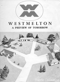
Document, West Melton: A preview of tomorrow, c.1969
... with lots of room for a pool and even a tennis court’ on huge one... with lots of room for a pool and even a tennis court’ on huge one ..."In April 1969, the first major residential development in Melton began with the release of 148 homes for purchase. This was the first stage of a staggered release of a planned 30,000 homes for 100,000 people by 1990. The development, called Westmelton Satellite City, was described as ‘a preview of tomorrow’.101 It was the first estate built in a ‘modern’ style, with curved streets, and dozens of culs de sac. Westmelton was also the first major development in Victoria to build all the supply lines to the houses – including electricity and telephone lines – underground. The six different home designs in Westmelton were ‘specially designed for the future’, and with allotments ten feet wider than regulations required, there was plenty of ‘space for gracious living’ and for a family swimming pool. The developers of this new estate were active in promoting Westmelton as a new community within the Shire of Melton. By 1971, the Westmelton City News reported that Ian McIntosh, General Manager of Westmelton, had given away $100,000 on behalf of the company ‘to aid community projects’. This included a $72,000 donation towards building a community centre in Westmelton, and $25,000 for the shire’s Olympic-sized swimming pool. Ian McIntosh and his family moved to Melton and Ian said he was ‘very much aware of the needs of [the] Westmelton community’. By the end of 1971, Westmelton was home to 100 new families. The modern residences were obviously an appealing drawcard, but so was the country feel that characterised Melton. Mrs C. Allen, described as a ‘housewife’, said she and her husband chose to move to Westmelton because of ‘the quality homes ... and we both love the clean, fresh, natural environment that surrounds us’. Similarly, Mr W. Coxhead, insurance consultant, moved to Westmelton because of the ‘clean, fresh country air’. Accountant Mr B. Swanton echoed their sentiments, describing Westmelton as ‘far enough away from the industrial pollution carried over Melbourne suburbs by prevailing westerly winds’. The new development attracted an increasing number of young, professional couples and families, representing the beginning of a significant shift from the predominantly rural and farming community of the district’s past. The Westmelton development had four different ‘neighbourhoods’ designed to cater to a variety of different lifestyle needs. Westmelton was the first to be established, followed by Brookfield, which offered ‘superb land in a rustic setting’. Brookfield Acres offered ‘wide open spaces with lots of room for a pool and even a tennis court’ on huge one-acre blocks, while Westlake was an innovative development with ‘different sized homesites’ and ‘lakeside living’.Westmelton was the first of many residential developments that would come to play a huge role in shaping the shire in the decades to follow".A marketing brochure for the Westmelton Satellite City developmentlocal significant events, council -
 Tennis Australia
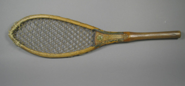
Racquet, Circa 1790
... An late 18th century court tennis racquet, made from two... Park Melbourne melbourne Tennis An late 18th century court ...An late 18th century court tennis racquet, made from two pieces of interlocked wood, secured with two screws. One is the handle/throat, the other is the shoulders/head. The latter unfortunately had, at some point in the past, split at the crown, and whipping was applied to reinforce it. The gut stringing is three-way. The throat and lower shoulders have been hand painted, with both linear and floral designs. Across the thoat on the obverse is the monogram which reads 'BWB'. Materials: Wood, Lacquer, Metal, Gut, Paint, Stringtennis