Showing 2426 items
matching township
-
 Clunes Museum
Album - PHOTO ALBUM
Photo album prepared for application in 1990 "Tidy Town" CompetitionExample of community pride and co-operationLeather look photo album, embossed, gold lettering, containing photos, descriptions, and itinerary of judge of competitionEntry of Clunes township in tidy town competition 1990 (inside front cover)photo album, tidy town competition -
 Phillip Island and District Historical Society Inc.
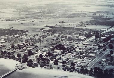
Photograph, 1940's 1950's
Photograph donated by John JanssonBlack & White aerial view of the Cowes Township and jetty area, Phillip Islandcowes phillip island, aerial view of cowes, cowes jetty, cowes pier phillip island, john jansson -
 Phillip Island and District Historical Society Inc.
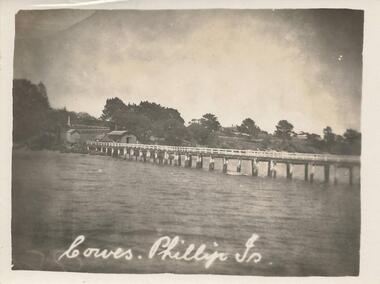
Photograph, Early 20th Century
One of a collection of 8 photographs donated by Bob Notley of San RemoBlack & White photograph of the Cowes Pier looking towards sheds and Cowes Township.Cowes, Phillip Is.cowes pier, cowes jetty, bob notley -
 Phillip Island and District Historical Society Inc.
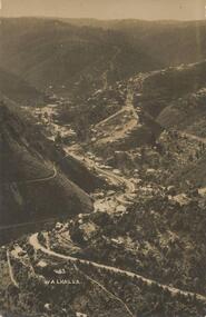
Photograph - Post Card, Late 19th Century
Photograph donated by Jean ArchibaldBlack & White Photograph of the road winding through the hills of Walhalla township, VictoriaFront: "Walhalla 43" Back: "To M with love from G W" "write soon"walhalla victoria, jean archibald, mining town -
 Buninyong & District Historical Society
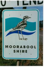
Photograph - Original Photograph, Mr. C.J. Brooks, Moorabool Shire sign closeup, September 1995
Social, historicalExample of the Moorabool Shire sign in the late twentieth centuryColour photo, closeup of the Moorabool Shire sign on the Western outskirts of the township of Yendonroad signs, yendon, moorabool shire, streetscape -
 Clunes Museum
Photograph, UNKNOWN
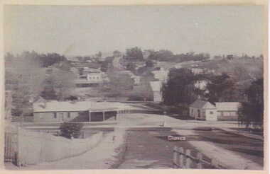
BLACK AND WHITE PHOTOGRAPH OF CLUNES TOWNSHIP. TAKEN FROM CAMERON STREET HILL.local history, photography, photographs, clunes township -
 Clunes Museum
Photograph
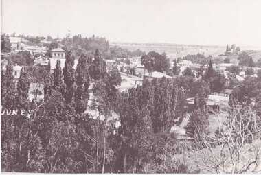
COPY OF BLACK AND WHITE PHOTOGRAPH OF CLUNES TOWNSHIP, TAKEN FROM LUGG STREET.local history, photography, photographs, clunes township -
 Clunes Museum
Photograph, CIRCA 1880
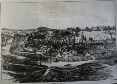
AN ETCHING OF VERY EARLY CLUNES. TREE GUARDS AROUND TREES ALONG CREEK BANK, ORIGINAL NAMED TULLAROOP CREEK.CLUNES TOWNSHIP, CRESWICK CREEK, DOUBLE STORY BUILDINGS AND MINE POPPET HEADS.TOWN OF CLUNESlocal history, photography, photographs, clunes township. -
Whitehorse Historical Society Inc.
Document, Division of Survey and Mapping, 1984
Information guide to Parish and Township Plans - Division of Survey and Mapping - Victorian Government..Information guide to Parish and Township Plans - Division of Survey and Mapping - Victorian Government..Information guide to Parish and Township Plans - Division of Survey and Mapping - Victorian Government..crown lands, victorian government, land surveys -
 Stawell Historical Society Inc
Photograph, Open Cut Big Hill overlooking Stawell towards Grampians
Scotts Open Cut Big Hill c 1960 overlooking Stawell towards Grampians. The first quartz was mined for in the open cut from Fisher Street, to the Big Hill, below the Pioneers Memorial.Black and white photograph of an open cut on the side of a big hill. The township in the background.stawell mining -
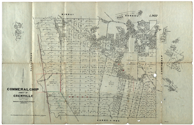 Federation University Historical Collection
Plan, Commeralghip, County of Grenville, 1905, 03/02/1905
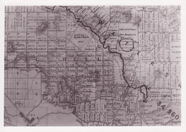
The Township of Kaleno is in the Pitfield Plains. The Cape Clear Cemetery T contains the graves of miners and local pioneering families from the Cape Clear, Hollybush, Kaleno, Pitfield Plains, Pitfield, Illabarook, Berringa, Springdallah, Wallinduc, Glenfine, Happy Valley and Western Creek districts.Plan of allotments in Commeralghip, County of Grenville, Victoria. The plan includes the township of Kaleno, Dereel Pre-Emptice Right (John Cullen), Commeralghip Pre-Emptive Right (John Gordon McMillan and Glenfine Pre-Emptive Right (William Rowe). It also includes landholders such as Robert mcPherson, C. Cameron. John Boyd, John Cullen, W.T. Rowe, George Currie, J.P. Mackay, T. McCaffery, G. Hawkins, Alexander McPherson, C. Cameron. Gift of the Squire Family, 2014commeralghip, pitfield plains, kaleno, dereel, glenfine, squire, richard squire, w.t. rowe, john cullen, alexander mcpherson, george currie, mt misery, william rowe, mindai, john gordon mcmillan -
Clunes Museum
Photograph, CLUNES IN THE 1860'S
CRITERION. QUARTZ MINING COMPANY REGISTERED CLUNES VIEW IN TOWNSHIP, CLUNES, SOUTH EAST CAMP PARDE, CLUNES, SOUTH WEST PORT PHILLIP AND COLONIAL GOLD MINING COMPANY, CLUNES VICTORIAN QUARTZ MINING COMPANY, REGISTERED CLUNESCLUNES IN THE 1860S FIVE VIEWS BY CHARLES NETTLETON .1 LARGE ENVELOPE WITH DESCRIPTIONS OF EACH OF THE PHOTOS. PUBLISHED BY SHIRE OF TALBOT AND CLUNES FROM ORIGINAL PHOTOGRAPHS. .2 PHOTO PRINT - VIEW IN TOWNSHIP, CLUNES, SOUTH EAST .3 PHOTO PRINT - CAMP PARADE, CLUNES, SOUTH WEST .4 PHOTO PRINT - PORT PHILLIP AND COLONIAL GOLD MINING COMPANY, CLUNES .5 PHOTO PRINT - VICTORIA QUARTZ MINING COMPANY, REGISTERED, CLUNES .6 PHOTO PRINT - CRITERION QUARTZ MINING COMPANY, REGISTERED. CLUNESC. NETTLEFOLD, HOTO, MELBOURNElocal history, photography, photographs, mining, clunes in the 1860's five views by charles nettlefold -
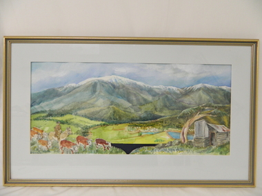 Kiewa Valley Historical Society
Painting, Cattlemen of the Bogong High Plains, c1995
Leo Wimmer who lived locally was commissioned to do the painting for the Mt Beauty, S. K. Pearce Pty. Ltd., Supermarket as a display was wanted to fit against the blank walls opposite the cash registers (where the liquor store is now). His idea was to break up the parts in the painting and use these as large replicas painted on wood for the display. An official opening was held and Leo used the money earned to visit his homeland, Austria. Leo trained as a restorer of church art in Austria.This painting was commissioned for a Cattlemen's display behind the cash registers at the Mt Beauty S. K. Pearce Supermarket. Each part of the foreground was painted separately onto stand alone boards -the cattle, the hut, the grass and the Mt Beauty township. Leo Wimmer lived locally and was a professional frame conservator. Leo Wimmer specialised in gilding and worked at the National Gallery of Victoria and later the National Gallery of Australia (NGA Nov. 1981 - 1990) where he was responsible for conservation of gilded frames in the national collection. This involved crafting of missing pieces on period frames, conservation/restoration of gilded surfaces, crafting of period frames, and lecturing at galleries and institutions on gilding, wood carving, Australian frame history and crafting of period frames. Framed painting of Mt Bogong with cattle, Mt Beauty township and cattleman's hut in foreground.Circular watermark (illegible) on bottom right corner. "Wimmer / 1" is underneath the watermark.cattlemen; bogong high plains; s.k.pearce; mt beauty supermarket; leo wimmer; -
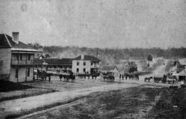 Federation University Historical Collection
Photograph - Image, Buninyong, 1859 - Looking North, 1859
Buninyong was Victoria's first inland town, and is in close proximity to Ballarat. The fledgling township of Buninyong. Early buildings line the streets, and horse drawn carriages are evident. buninyong -
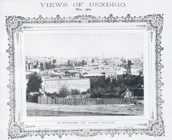 Bendigo Historical Society Inc.
Photograph - VIEWS OF BENDIGO: TOWNSHIP OF LONG GULLY, c. 1870's
Photograph No. 28: Sepia photograph of Township of Long Gully. (Two Copies) Nicholas CairN J Caireplace, landscape view, golden square -
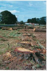 Buninyong & District Historical Society
Photograph - Original Photograph, Mr. C.J. Brooks, Main street of Yendon from the West showing felled pine trees and tree stumps, September 1995
Social, historicalExample of the felling of trees for power company in the late twentieth centuryColour photo, of the Western outskirts of the township of Yendon showing felled pine trees and stumps yendon, moorabool shire, streetscape, felled pinetrees, powercor -
Tatura Irrigation & Wartime Camps Museum
Folio, Murchison Memoirs. A Trevaskis, May, 1990
Family History of A. Trevaskis32 pages of recollections by A. Trevaskis of his Family and Murchison families and Township 187 - 01990My Memories of Murchison by Arthur Trevaskisdocuments, biography -
 Hume City Civic Collection
Photograph
A b/w photograph of a landscape view showing Jackson's Creek with the Sunbury township in the background.Handwritten on back: McMahonmcmahon, landscapes, jackson's creek, sunbury, george evans collection -
Clunes Museum
Document - POSTCARD AND REPORT, UNKNOWN
POSTCARD OVERVIEW OF CLUNES TOWNSHIP, TOGETHER WITH A BRIEF REPORT REGARDING THE CLUNES POST OFFICElocal history, documents, reports, postcards, clunes post office, clunes township -
 Clunes Museum
Photograph
PHOTO COPY. WATERSHED DAMS WEIR CREEK FOR THE COLLECTION OF WATER FOR THE CLUNES TOWNSHIP AND MINES.local history, photography, photographs, water supply -
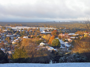 Ballarat Heritage Services
Photograph - Digital photographs, L.J. Gervasoni, View of Daylesford in Snow from Wombat Hill Botanic Gardens, c2012-2016
Daylesford is a Central Victorian town. Colour photograph from the Wombat Botanical Gardens showing snow covering the township of Dayelsford. daylesford, snow, weather, climate, winter, daylesford botanic gardens, botanic gardens, wombat hill, wombat hill botanic gardens, cityscape, viewscape -
Lakes Entrance Regional Historical Society (operating as Lakes Entrance History Centre & Museum)
Postcard, 1940 c
Also an identical image slightly damaged 04528.1Black and white postcard showing the mountains in distance beyond the valley and township of Buchan Victoriarecreation, tourism -
 Falls Creek Historical Society
Postcard - Mt. Beauty, Victoria
These photographs were taken in and around Mount Beauty and the Kiewa Valley by Samuel Keith Pearce and printed for him as a foldout postcard by NuColor Vue. The postcards state they were printed for S. K. Pearce Pty. Ltd of Tawonga and Mount Beauty. Samuel Keith Pearce was born on 24 June 1917 in Armadale, Victoria. By the late 1940s he owned the Mt Beauty Supermarket, Newsagency, Drapery and Hardware store at Mount Beauty and also a store at Tawonga in partnership with his brother Gordon Cathew Pearce. For some time, they operated as Pearce Brothers. In the early 1960s Keith also opened a mini mart In Falls Creek. As well as being a keen photographer and an astute businessman, Keith Pearce was a well-known identity in the Kiewa Valley, making many contributions to the development of the area over a long period. This included serving as a member of the Bright Shire Council for many years. He worked hard to promote the interests of the Upper Kiewa Valley. As a sign of recognition and appreciation for his contribution to the community, the park opposite the grocery store in Mount Beauty was named the SK Pearce Gardens in his honour. Samuel Keith Pearce died on 7 July 1994 in Mount Beauty, Victoria Mt. Beauty at the head of the Kiewa Valley was established by the State Electricity Commission during the development of the Kiewa Hydroelectric Scheme. It forms the gateway to the Bogong High Plains, and is a popular centre for holiday makers in the north-east providing accommodation and access to excellent fishing grounds and, in winter, to the popular ski slopes of nearby Falls Creek.This collection of postcards and images is significant because they were commissioned by a highly successful businessman in Falls Creek, Victoria.A colour image of Mt. Beauty Township and Mt. Bogong from Power Line Lookout.mt. beauty, s. k. pearce -
 Wodonga & District Historical Society Inc
Map - Boorgunyah - "The Town that never was"
At the height of the river trade, there was a town surveyed and laid out, and streets were named. This town was to house the workers at the river port of Red Bank when the paddle steamers plied the Murray River as far as Albury, carrying produce such as wool and wheat to the various towns along the river in the 1800s. As the river trade died away, this town never went ahead – one might say, “The town that never was.” A lone gum tree stands on the site today.This item is significant because it documents plans which were made for the early development of Wodonga.A black an white map depicting the proposed location of the township. The map is based on a sketch and is not to scale,early wodonga, boorgunyah - "the town that never was", wodonga heritage -
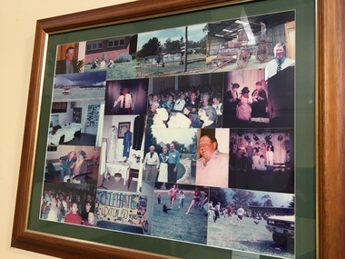 Pyrenees Shire Council
Photographs, Lexton 150th Celebrations (1 of 2), c1995
significant to the Pyrenees Shire and Lexton communityframed photo montage"Inscribed front: 150th Birthday Celebration Lexton Township 4-5 Nov 95" -
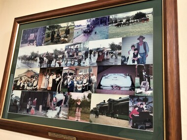 Pyrenees Shire Council
Photographs, Lexton 150th Celebrations (2 of 2), c1995
significant to the Pyrenees Shire and Lexton community"Inscribed front: 150th Birthday Celebration Lexton Township 4-5 Nov 95" -
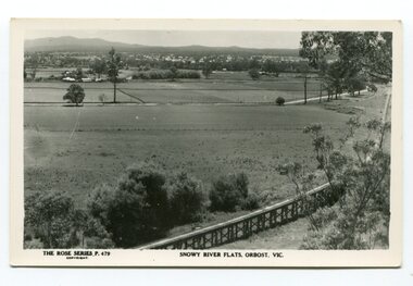 Orbost & District Historical Society
black and white photograph, Rose Stereograph Company, first half 20th century
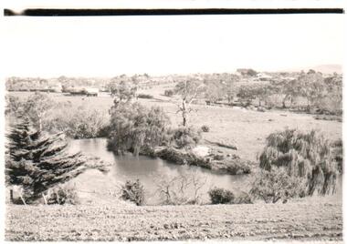
The two bridges on the railway viaduct, which crosses the Snowy River floodplain at Orbost, were built from local Southern Mahogany. The bridge on the Bairnsdale end (770m) is now the longest in Victoria. Despite various attempts to extend the line, the station stayed on the western side of the Snowy River. (info. Helen Martin)This item is associated with the history of the Orbost-Bairnsdale railway line and therefore reflects the role that the rail line played in the social and economic history of Orbost.A black / white photograph / postcard of the Orbost township in the background and the railway viaduct over the flats in the foreground.photo caption - The Rose Series P.479 copywright SNOWY RIVER FLATS, ORBOST, VIC"east-gippsland-railway orbost-viaduct -
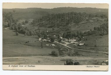 Orbost & District Historical Society
black and white photograph, Howard D. Bulmer, first half 20th century
This is a pictorial record of Buchan in the first half of the 20th century.A black / white photograph / postcard of a township in a valley. The photograph has been taken from a distance.on front - A Distant View of Buchanbuchan -
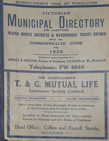 Federation University Historical Collection
Book - Street Directory, Arnall & Jackson Pty Ltd, Victorian Municipal Directory and Gazatteer, 1939, 1939
Beige cover with blue spine. 1052 pages. It includes an index to townships, parishes and Railway stations. non-fictionvictorian municipalities, municipal, councils, water supply, advertisements, aboriginal protection board, agriculture, charities, county court, crown lands and survey, engine drivers board, licensing court, sludge abatement board, cities, towns, boroughs, ballarat, buninyong, gordon, grenville, talbot, traralgon, ballaarat, happy valley, bungaree, daylesford, glenlyon, glenlyon shire, hepburn springs -
Federation University Historical Collection
Book - Directory, Arnall & Jackson Pty Ltd, Victorian Municipal Directory and Gazatteer, 1935, 1935
Brown cover with maroon spine. 801 pages. It includes an index to townships, parishes and Railway stations. non-fictionvictorian municipalities, municipal, councils, water supply, advertisements, aboriginal protection board, agriculture, charities, county court, crown lands and survey, engine drivers board, licensing court, sludge abatement board, cities, towns, boroughs, ballarat, buninyong, gordon, grenville, talbot, traralgon, ballaarat, happy valley, bungaree, daylesford, glenlyon, glenlyon shire, hepburn springs