Showing 432 items matching "utility"
-
 Kew Historical Society Inc
Archive (series) - Subject File, Light Pillars
Kew Historical SocietySince its foundation in 1958, members of the Kew Historical Society have been compiling and storing information about subjects relating to the history of Kew and its environs, of which this file is an example. Arranged by Secondary Values (value of records to users)Subject file containing information about cast iron lamp pillars (posts). Included are copies of the KHS archivist's reply to an inquiry regarding the location of decorative civic light pillars in Kew (2013). These lamps were previously located in the Dorothy Rogers Reserve, and in the Raoul Wallenberg Memorial Garden. The lamps in 2013 were stored at the Kew Depot for restoration. Photos of the pillars can be seen in a number of historical photos of High Street, Kew.public utilities -- kew (vic.), street lighting -- history --- kew (vic.)public utilities -- kew (vic.), street lighting -- history --- kew (vic.) -
 Surrey Hills Historical Society Collection
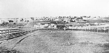
Photograph, Looking towards Box Hill from the site of the Surrey Hills Golf Club, 1902, 1902
Reproduced by permission of Mr John Arnold from his book: "The Riversdale Golf Club - a history, 1892-1977." Copyright to book: Riversdale Golf Club. Surrey Hills Golf Club operated from 1892-1908 then moved and became Riversdale Golf Club. The game was played across paddocks from Trafalgar Street, Mont Albert to Whitehorse Road and down Victoria Crescent to where Box Hill TAFE is now located in Elgar Road. There were problems with cows eating the tee flags! The clubhouse still exists as 30 Trafalgar Street.Black and white photo with a large grassy paddock in the foreground. From the bottom left and right post-and-rail fences converge on a group of large industrial buildings in the centre middle distance. In the background are paddocks and buildings."Top: Looking towards Box Hill from the links in 1902. The old Box Hill Gas Works is in the centre of the picture."sports grounds, surrey hills golf club, riversdale golf club, box hill gas works, gasworks, public utilities, gas -
 Wodonga & District Historical Society Inc
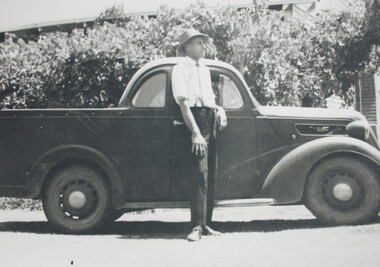
Photograph - Haeusler Collection Portrait of Alf Haeusler with Utility
The Wodonga Historical Society Haeusler Collection provides invaluable insight into life in late nineteenth and early twentieth century north east Victoria. The collection comprises manuscripts, personal artefacts used by the Haeusler family on their farm in Wodonga, and a set of glass negatives which offer a unique visual snapshot of the domestic and social lives of the Haeusler family and local Wodonga community. The Haeusler family migrated from Prussia (Germany) to South Australia in the 1840s and 1850s, before purchasing 100 acres of Crown Land made available under the Victorian Lands Act 1862 (also known as ‘Duffy’s Land Act’) in 1866 in what is now Wodonga West. The Haeusler family were one of several German families to migrate from South Australia to Wodonga in the 1860s. This photograph is of Alf Haeusler (b.1922), and is one of the many photographs in the Haeusler Collection that represent home and social life in early twentieth century Wodonga.This item is unique, has well documented provenance and a known owner. It forms part of a significant and representative historical collection which reflects the local history of Wodonga. It contributes to our understanding of domestic and family life in early twentieth century Wodonga, as well as providing interpretative capacity for themes including local history and social history.A black and white photograph of Alf Haeusler standing behind a 1930s ute.photograph, photographs, photography, portrait, ute, automobile, 1930s, haeulser, haeusler collection, wodonga -
 City of Kingston
Photograph - Black and white, c. 1958
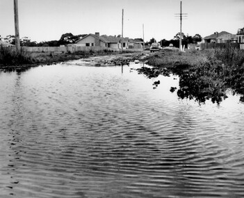
This photograph depicts flooding of Ozone Avenue in Beaumaris, located off Balcombe Road. Roads in the Beaumaris area lacked sufficient drains to clear surface water. In many cases streets were unsealed and without footpaths and some were dirt tracks. Gutters and road surfaces were made of clay and in the wetter months of winter, unsealed roads and tracks became impossible quagmires that were unnavigable for vehicles and pedestrians. In the first decade after World War II there was rapid expansion in construction of new houses in the suburb of Beaumaris. Utilities and infrastructure to support the growth of housing was inadequate and not provided for prior to the development of the area. Without rudimentary drainage, flooding was frequent. Storm water runoff, domestic sullage and septic tank overflow would form large pools and families were sometimes marooned within their homes. The frequent flooding caused isolation and hardship and residents endured difficulties with accessibility to facilities. These disadvantages had the potential to cause social issues for the new residents.Black and white photograph of flooding in Ozone Avenue, Beaumaris. The image shows floodwaters with boggy and rough terrain on an unsealed road with housing in the distance.Handwritten in blue ink: 2124 circled Handwritten in red ink: 80% Handwritten in blue ink on yellow Post-It note: Chap 6. underlined, 2194 Ozone Ave Beaumaris 1958beaumaris, ozone avenue, balcombe road, flooding, roads, infrastructure -
 City of Kingston
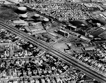
Photograph - Black and white, c. 1970
The Highett Gas Works were a landmark along the Nepean Highway for many years. With the cessation of the gasification of coal and the introduction of natural gas to Victoria, the gas holders were demolished and the Sir William Fry Reserve was developed on the southern end of the site. The Gas and Fuel redeveloped the northern end of the site with modern offices and laboratories for the organisation's scientific services. At this time, the chimney and retort house were retained.The Highett Gasworks had its beginning in 1939 operated by the Central Brighton and Moorabbin Gas Co Ltd. The company had expanded its gas production facilities to Highett where it had purchased 45 acres of land adjacent to the Melbourne-Frankston railway line. The first gasholder was erected on the Highett site in 1927 and connected with high pressure mains to the Brighton Gas Works. In 1939 the building program including gasometers, the vertical retort house and coal store was completed and gas making commenced. Its area of supply covered approximately 70 square miles and included the municipalities of Brighton, Sandringham, Moorabbin, Mordialloc, Chelsea and part of Dandenong. The Gas and Fuel Corporation eventually took over operations and with the disaggregation and privatisation of the organisation, the site was eventually closed c. 2002.Black and white aerial photograph featuring the Highett Gas Works with gasholders and retort house. In the top right-hand corner, a former Highett Primary School on Graham Road can be viewed. Photograph includes Bay Road, Royal Avenue, Princess Avenue and Jackson Road (Highett) and Alfred, Turner and Sandford Streets (Moorabbin).Handwritten in black ink: [indecipherable] in a circle Handwritten in red ink: 70% Four velcro display adhesivesgasification of coal, gas and fuel corporation of victoria, gasholders, highett, moorabbin, utilities -
 Lakes Entrance Historical Society
Photograph - State Electricity Office, 1978
SEC office closed 9 August 1993. Also second copy.Colour photograph of State Electricity office 247 Esplanade, showing display of white goods, which were sold by SEC during this period. Lakes Entrance VictoriaSEC officepublic utilities, local history -
Port Melbourne Historical & Preservation Society
Book, Public Works Committee, Borough of Sandridge, Municipal Council of Sandridge - Public Works Committee Minutes, 18560 - 1862
Volume of minutes of Public Works Committee of Sandridge Council dated 20.9.1860Title on labellocal government - borough of sandridge, engineering - roads streets lanes and footpaths, engineering - fences, engineering - canals and drainage, engineering - bridges, fishermans bend, built environment - civic, transport - horse, utilities - gas, sandridge lagoon, mission to seafarers, emerald hill, fire and fire services, william morley, joseph weaver allen, thomas swallow, samuel george isaacs, frederick poolman, robert byrne, john murphy -
Port Melbourne Historical & Preservation Society
Book - Borough of Sandridge, Charles Clay, Borough Surveyor, Surveyor's Reports, 1877
Surveyor Charles CLAY's reports to Council March 1877 to June 1882, handwritten. 176pp volume bound in maroon linen with red spine; sticker on front: MINUTE BOOK; 'Surveyor's Reports' hand printedThree names/addresses noted on first page. Two printed Agendas 1881 and 1882 pasted in front.local government - borough of sandridge, engineering - roads streets lanes and footpaths, port melbourne town hall, transport - tramways, engineering - canals and drainage, celebrations fetes and exhibitions, business and traders, fishermans bend, fire and fire services, flood, engineering - bridges, utilities, health - general health, built environment - domestic, industry - manufacturing, livestock, transport - railways, charles clay, sandridge lagoon, business and traders - hotels -
 Port Melbourne Historical & Preservation Society
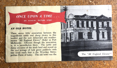
Booklet, Melbourne and Metropoltan Board of Works, Once Upon a Time ... An M.M.B.W. Picture Story, 1950
"Once Upon a Time ... An MMBW Picture Story" Small oblong booklet. Front cover red banner title and B&W photo of the All England Eleven Hotel. Describes history of Melbourne's sewerage systemutilities - sewerage, engineering - board of works, armed services - air force, built environment - commercial, business and traders - hotels, all england eleven hotel, mmbw, werribee metropolitan farm, pier hotel, melbourne and metropolitan board of works -
 Port Melbourne Historical & Preservation Society
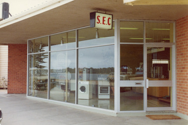
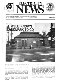
Photograph - Sub-station, corner Williamstown Road and Ingles Street, Electricity News, Spring, 1973
Photo of front page of 'Electricity News', Spring 1973, showing an electricity main supply sub-station at the corner of Williamstown Road and Ingles Strreet, shortly before demolitionbuilt environment, utilities - electricity, city of port melbourne - electricity supply dept. -
 Trafalgar Holden Museum
Vehicle - Holden FC Sedan, 1956
Although the FC series was substantially the same as the FE, it featured revisions to the radiator grille, body trim and interior. Minor mechanical improvements were also made, with changes to the engine, suspension, brakes, gearchange linkages and the steering box The Utility now featured painted rather than chromed grille and headlight rims, as did the Panel Van. All FC models were powered by a 132-cubic-inch (2.2 L) six-cylinder engine producing 72 bhp (54 kW). This engine was carried over from the FE series, although the camshaft was altered, the compression ratio was increased and torque was improved.[ the FC was replaced by the Holden FB series in January 1960 The FC was the first Holden to be regularly available in Indonesia.two tone green body 4 door sedan. Single piece windscreenHolden Registration number 63451-Hautomobile, holden, vintage july 1956, car -
 Lakes Entrance Historical Society
Photograph - Childcare Centre, Lakes Post Newspaper, 1997
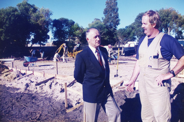
Built on former site of Primary School pine plantation.Colour photograph of the laying of the foundation slab for the Lakes Entrance Child Care Centre, at 45 Coates Road. Councillor Ray Hack and builder Phillip Baade discussing progress. Lakes Entrance Victoriapublic utilities, buildings -
 Lakes Entrance Historical Society
Photograph, 1999
In late 1958 bore put down in an attempt to obtain good quality water for a reticulated town water supply. Water unsuitable, but during drought years when water supply from Nicholson River was restricted, water from this bore available for public use. Bore plugged, structure removed December 2000. Site marked with plaque March 2001, by Lakes Entrance Historical Society.Colour photograph of the head works including feed pipe of water bore sunk in late 1958 on the Public Reserve bound by Marine Parade and the highway approach to North Arm Bridge, Lakes Entrance, Victoria.water supply, public utilities -
 Lakes Entrance Historical Society
Photograph - Tambo Shire Office, 1992
Colour photograph showing the north facing front entrance of the former Shire of Tambo office on Palmers Road, Lakes Entrance, Victoria.public utilities, local government -
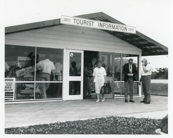 Lakes Entrance Historical Society
Photograph - Information Centre Lakes Entrance, Lakes Post Newspaper, 1993 c
Original centre built with voluntary labour, a Chamber of Commerce initiative. Business opened November 1987, officially opened by Joan Kirner.Black and white photograph of the Lakes Entrance Tourist Information Centre, showing original structure. Councillor Adeline Whelan and two men on forecourt, lots people inside. Lakes Entrance Victoriatourism, public utilities -
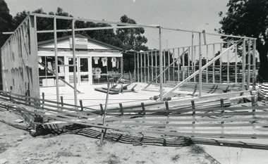 Lakes Entrance Historical Society
Photograph - Information Centre Lakes Entrance, 1993
Original centre was built by voluntary labour, a Chamber of Commerce initiative, officially opened November 1987, by Joan Kirner, building extension completed April 1993.Black and white photograph of the Tourist Information Centre, following building extension works. Lakes Entrance Victoriatourism, public utilities -
Bendigo Historical Society Inc.
Document - VLINE BENDIGO SIGNALLING DIAGRAM NO.44/89, 1989
BHS CollectionDetailed signalling diagram showing signal and interlocking arrangements, produced 1989 for Bendigo Rail Yard.bendigo, utilities, railways -
 Lakes Entrance Historical Society
Photograph - State Electricity Office, 2008
Date made August 2008Colour photograph of retail shop situated in what was once the SEC building on Esplanade, Lakes Entrance, Victoria. room display, public utilities -
 Bendigo Historical Society Inc.
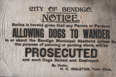
Document - PRINTED NOTICE (BENDIGO MUNICIPAL ABATTOIRS)
Printed Notice on cotton fabric (Bendigo Municipal Abattoirs) re prosecution of those allowing dogs to wander in the precinct and seizure/destroying of such dogs. Town Clerk: H. C. Ingletonorganization, public utility, bendigo abattoirs, advertising, public notices -
 Bendigo Historical Society Inc.
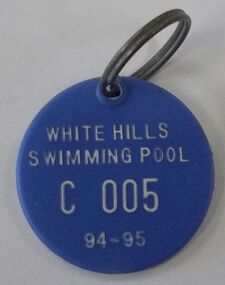
Memorabilia - WHITE HILLS SWIM PASS, 1994
White Hills Swimming Pool was established in 1946.White Hill Swim Pass: Blue plastic circular disc with a metal ring for attaching. Printed on the disc is * White Hills Swimming Pool C 005 94-95. Box 625organization, public utility, white hills swimming pool -
Lakes Entrance Historical Society
Book, Hopkins Andrew, The Journal of Occupational Health and Safety Australia and New Zealand Special Issue: Lessons from Longford the trial, 2002
Account of the Royal Commission findings from the Esso gas plant explosion in 1998 at Longford Victoria and the OHS trial held in Supreme Court Melbourne, where various legal aspects were examined. Indexedindustrial, public utilities -
Lakes Entrance Historical Society
Book, Hopkins Andrew, Lessons from Longford - The Esso Gas Plant Explosion, 2003
A Statement on the sociological aspects of the gas plant explosion at Longford, Victoria. On 25 September 1998 and lessons to be learned by companies and Government.public utilities, industrial -
Lakes Entrance Historical Society
Book, Holzer Louis L, Victorian Municipal Directory 1955, 1955
The 83rd edition of Victorian Municipal directory Commonwealth and State Guide and Water Supply record. Indexedgovernment, public utilities -
 Bendigo Historical Society Inc.
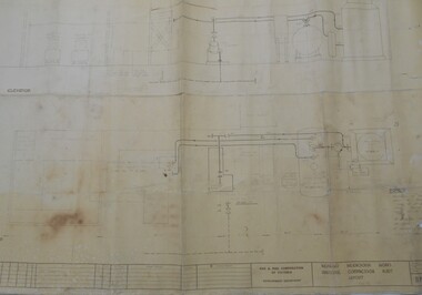
Map - BENDIGO WEEROONA GASWORKS MAP/PLAN COLLECTION: COMPRESSOR PLAN LAYOUT, 15.2.1971
Plan showing compressor plan layout at Bendigo Weeroona Gasworks. Prepared by Gas and Fuel Corporation Development Department.plan, bendigo, bendigo weeroona gas works, gasworks, public utility, gas and fuel corporation -
 Lakes Entrance Historical Society
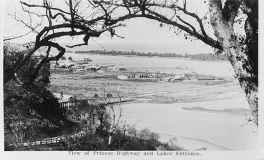
Postcard - View from Jemmys Point, 1920c
Also 1x Miniature postcard 6cmx8.5cm ' A Glimpse of Lakes Entrance' 01153-4Black and white miniature photographic postcard showing the North Arm Bridge prior 1937; post and rail fence around Kalimna road; township, Club Hotel and stables; jetties in Cunninghame Arm, Methodist Church; and sand hummocks. Telegraph line around hill and across sand flat. Lakes Entrance Victoriabridges, hotels, fences, public utilities -
Lakes Entrance Historical Society
Book, Kernot, Maurice Edwin, Bairnsdale-Orbost Rail, 1917
A printout of part of the Paper and Discussion of the construction of the Bairnsdale to Orbost Railway with emphasis on bridges.public utilities, bridges -
Lakes Entrance Historical Society
Book, Tambo Water Board, Tambo Shire Water reports 1989,1990, 91, 92, 1989
Report of activities financial statement of accounts list of Principal Officers and Staff of the Tambo Water Board Lakes Entrance Victoriapublic utilities -
Moorabbin Air Museum
Drawing (item) - Thorpe T211 Air tug Air utility cargo and ambulance configuration Codock Javelin Widgeon Pellarini PL 1 Beechcraft Hodgekiss agricultural plane Gypsy master Seagull replacement Poltergeist Premier Porsche 678 Binatang Empire flying boat bomb panel Seagull replacemnt RMIT Honey bee Elan aerobatic Victa air tourer Transavia air truck PL 12 Starlet ultralight Gypsy major helicopter De Havilland DH50 Essendon aerodrome 1926 Cobram flight, Miscellaneous Aircraft Drawings
-
 Bendigo Military Museum
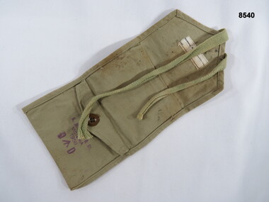
Equipment - SEWING KIT POUCH, B. MILBURN & CO, 1956
Small khaki two pocket universal personal sewing kit pouch, there is one open pocket and one pocket secured by a button, the closure flap is secured by a sewn on cotton strap.“FOLWER” (open to interpretation) Lower pocket “B. MILBURN & CO” “VICTORIA 1956 D^D”passchendaele barracks trust, pouch, two pocket utility -
 Lakes Entrance Historical Society
Photograph - Mallacoota Powerhouse, M Fish, 1980 c
Also colour photograph of old truck and oil drums beside same building 5386.1 10 c 12.5 cmColour photograph of old Mallacoota Power House which generated electricty to Mallacoota for many years until SEC power arrived in 1972 Mallacoota Victoriapublic utilities, public works