Showing 1167 items
matching view place
-
 Ringwood and District Historical Society
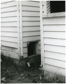
Photograph, Edwin G. Adamson A.R.P.S, Toilets in Civic Place, Ringwood 1962 (Eastland Litigation Photos)
This series of SS0380 photos are part of the "Eastland Litigation" launched in 1962 by the Whitehorse Traders Co-operative Association (WTCA), against the Ringwood Council's Interim Development Order of 1960. WTCA sought "orders from the Supreme Court of Victoria that the planning scheme was invalid" - See "The Eastland Litigation" chapter in "From Horse Shoes to High Heels - Ringwood Shopping Centre and Eastland 1858-2008" by Richard Carter, Bounce Books 2009.2xBlack and WHite PhotographsWritten on back of photograph 2838-1: 'Photo of the toilets in Civic Place, showing doors broken off. See pan exposed to public view'. Stamped on photograph, 'Edwin G. Adamson...May 62'. Written on back of photograph 2838-2: 'Photo of the toilets in Civic Place, showing doors broken off where pans slide into toilets. Pans open to air, flies, etc. Used by occupiers of 'The Block'. Stamped on photographs, 'In the Supreme Court 13 Aug 1963' and 'Edwin G. Adamson...May 63'. -
 Ringwood and District Historical Society
Photograph, Civic Place, Ringwood 1984 (2 views)
... , "Civic Place, 1984". Civic Place, Ringwood 1984 (2 views ...Written on back of photographs, "Civic Place, 1984". -
 Ringwood and District Historical Society
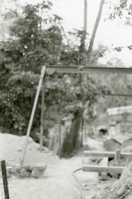
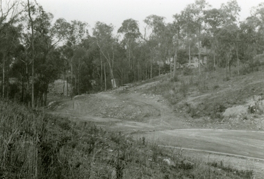
Photographs, 1979-80 MMBW pipe line project at Hubbard Reserve, North Ringwood � View along line work in Hibberd's and Chalkley's
Part of a 43-photo record of the MMBW�s engineering feat in drilling a 12 inch pipe line up to 40 feet deep through rock hardened by volcanic action associated with geological fault that occurs along the line. The work took place from October 1979 to May 1980 on the southern boundary of Hubbard Reserve, North Ringwood. The collection was presented to the Ringwood Historical Research Group by J Clarke on 9th June 1980.E560 N27 Jan 1980 A43 View along line work in Hibberd's and Chalkley's (lot 9 and 8) -
 Ringwood and District Historical Society
Photographs, 1979-80 MMBW pipe line project at Hubbard Reserve, North Ringwood � View behind no. 39 Burlock Avenue showing compressor, mole pit cover and the big box tree
Part of a 43-photo record of the MMBW�s engineering feat in drilling a 12 inch pipe line up to 40 feet deep through rock hardened by volcanic action associated with geological fault that occurs along the line. The work took place from October 1979 to May 1980 on the southern boundary of Hubbard Reserve, North Ringwood. The collection was presented to the Ringwood Historical Research Group by J Clarke on 9th June 1980.E560 N26 Jan 1980 A43 View behind no. 39 Burlock Avenue showing compressor, mole pit cover and the big box tree -
 Ringwood and District Historical Society
Photographs, 1979-80 MMBW pipe line project at Hubbard Reserve, North Ringwood � View east, sewer work line showing grate over pit
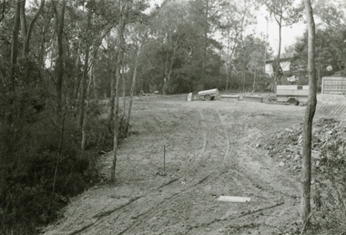
Part of a 43-photo record of the MMBW�s engineering feat in drilling a 12 inch pipe line up to 40 feet deep through rock hardened by volcanic action associated with geological fault that occurs along the line. The work took place from October 1979 to May 1980 on the southern boundary of Hubbard Reserve, North Ringwood. The collection was presented to the Ringwood Historical Research Group by J Clarke on 9th June 1980.E560 N30 Feb 1980 A43 View east, sewer work line showing grate over pit -
 Ringwood and District Historical Society
Photographs, 1979-80 MMBW pipe line project at Hubbard Reserve, North Ringwood � View along MMBW work line in east end of Hibberd's, showing grating over mole boring pit
Part of a 43-photo record of the MMBW�s engineering feat in drilling a 12 inch pipe line up to 40 feet deep through rock hardened by volcanic action associated with geological fault that occurs along the line. The work took place from October 1979 to May 1980 on the southern boundary of Hubbard Reserve, North Ringwood. The collection was presented to the Ringwood Historical Research Group by J Clarke on 9th June 1980.E560 N29 Feb 1980 A43 View along MMBW work line in east end of Hibberd's, showing grating over mole boring pit -
 Ringwood and District Historical Society
Photographs, 1979-80 MMBW pipe line project at Hubbard Reserve, North Ringwood � Viewing east from Debbie Place
... Reserve, North Ringwood � Viewing east from Debbie Place ...Part of a 43-photo record of the MMBW�s engineering feat in drilling a 12 inch pipe line up to 40 feet deep through rock hardened by volcanic action associated with geological fault that occurs along the line. The work took place from October 1979 to May 1980 on the southern boundary of Hubbard Reserve, North Ringwood. The collection was presented to the Ringwood Historical Research Group by J Clarke on 9th June 1980.E568 N18 13 May 1980 A43 Viewing east from ridge above Debbie Place -
 Ringwood and District Historical Society
Photographs, 1979-80 MMBW pipe line project at Hubbard Reserve, North Ringwood � View east up the gully
Part of a 43-photo record of the MMBW�s engineering feat in drilling a 12 inch pipe line up to 40 feet deep through rock hardened by volcanic action associated with geological fault that occurs along the line. The work took place from October 1979 to May 1980 on the southern boundary of Hubbard Reserve, North Ringwood. The collection was presented to the Ringwood Historical Research Group by J Clarke on 9th June 1980.E568 N19 13 May 1980 A43 View east up the gully, when all the work was finished -
 Ringwood and District Historical Society
Photographs, 1979-80 MMBW pipe line project at Hubbard Reserve, North Ringwood � Boring mole pit
Part of a 43-photo record of the MMBW�s engineering feat in drilling a 12 inch pipe line up to 40 feet deep through rock hardened by volcanic action associated with geological fault that occurs along the line. The work took place from October 1979 to May 1980 on the southern boundary of Hubbard Reserve, North Ringwood. The collection was presented to the Ringwood Historical Research Group by J Clarke on 9th June 1980.E561 N14 3 March 1980 A43 View west behind No. 29 Burlock Avenue, showing gantry over manhole 38 feet deep. -
 Flagstaff Hill Maritime Museum and Village
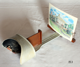
Leisure object - Stereoscope, H C White, Late 19th century
The development of stereoscopic photography views or stereographs was immensely popular in the United States and Europe from about the mid-1850s through the early years of the 20th century. First described in 1832 by English physicist Sir Charles Wheatstone, stereoscopy was improved by Sir David Brewster in 1849. The production of the stereograph entailed making two images of the same subject, usually with a camera with two lenses placed 6 cm apart to simulate the position of the human eyes, and then mounting the positive prints side by side laterally on a stiff backing. Brewster devised a stereoscope through which the finished stereograph could be viewed; the stereoscope had two eyepieces through which the laterally mounted images, placed in a holder in front of the lenses, were viewed. The two images were brought together by the effort of the human brain to create an illusion of three-dimensionality. Stereographs were made of a wide range of subjects, the most popular being views of landscapes and monuments and composing narrative scenes of a humorous or slightly suggestive nature. Stereoscopes were manufactured for various price ranges and tastes, from the simple hand-held device introduced by Oliver Wendell Holmes who promoted stereography through articles to elaborate floor models containing large numbers of images that could be flipped into place. The stereograph became especially popular after Queen Victoria expressed interest in it when it was exhibited at the 1851 Crystal Palace Exposition. Like television today, stereography during the second half of the 19th century was both an educational and a recreational device with a considerable impact on public knowledge and taste. The Fine-art Photographers' Publishing Co. published many stereoscopic pictures from many different photographers from around the world under license. They also not only sold these images of various scenes and of famous people of the time but also were retail sellers of the viewers with the subject item having been made in the USA probably by H C White who held the patent for the subject items design from 1895 to 1902.An item that was very popular from the mid 19th century through to the beginning of the Edwardian period. Used for entertainment and also educational purposes and significant as it gives us a snapshot into the Victorian era and its social and domestic societal norms. Stereoscope viewer with adjustable view-finder that has a padded nose rest. The slide holder can move along the channel to suit the viewer. Made in London by the Fine-art Photographers' Publishing Co. Printed on metal plate "THE FINE-ART PHOTOGRAPHERS' PUBLISHING CO. 48 Rydevale Rd, LONDON, S.W." Embossed on viewing cup "U.S.A. PATENT OCT.15.1895" "CANADA / FRANCE / GERMANY / D'R''G'M' NO. 53803" "JUNE 3.1902 / FEBY 1.1896 / B.S.G.D.B. / GREAT BRITAIN / AUSTRIA / BELGIUM"warrnambool, shipwrecked-coast, flagstaff-hill, flagstaff-hill-maritime-museum, maritime-museum, flagstaff-hill-maritime-village, stereoscope, stereographs, stereoscope viewers, home entertainment -
 Flagstaff Hill Maritime Museum and Village
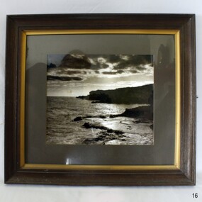
Photograph - Costal View, A. Wilkins, c.1950-1983
Item believed to be of modern creation used to augment a room display A modern item produced after 1950 that is not associated with a historic event, person or place therefore is regarded as having no significance for Flagstaff Hill museum collectionPhotograph of coastal scene in dim light. Frame is dark wood with gold edging around photograph. Inscription. Marked A. Wilkins.Marked, bottom right; "A. Wilkins"flagstaff hill, warrnambool, maritime museum, maritime village, great ocean road, shipwreck coast, sea scape, a. wilkins -
 Flagstaff Hill Maritime Museum and Village
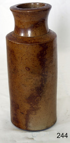
Ceramic - Stoneware Bottle, 1890-1940
Stoneware is a rather broad term for pottery or other ceramics that is fired at a relatively high temperature. A modern technical definition is a vitreous or semi-vitreous ceramic made primarily from stoneware clay or non-refractory fire clay. Whether vitrified or not, it is non-porous, it may or may not be glazed. Historically, across the world, it has been developed after earthenware and before porcelain and has often been used for high-quality as well as utilitarian wares. As a rough guide, modern earthen wares are normally fired in a kiln at temperatures in the range of about 1,000°C (1,830 °F) to 1,200 °C (2,190 °F); stoneware's at between about 1,100 °C (2,010 °F) to 1,300 °C (2,370 °F); and porcelains at between about 1,200 °C (2,190 °F) to 1,400 °C (2,550 °F). Historically, reaching high temperatures was a long-lasting challenge, and temperatures somewhat below these were used for a long time. Earthenware can be fired effectively as low as 600°C, achievable in primitive pit firing, but 800 °C was more typical. Stoneware also needs certain types of clays, more specific than those able to make earthenware, but can be made from a much wider range than porcelain. A domestic item used to store food products as glazing makes the container non-porous, often used for pickling. Or larger containers for kitchen flour. Items age is difficult to determine given the same techniques for making stoneware are in use today. Stoneware containers were made by many potteries in Australia and England. They were in common domestic use before plastics were invented around 1940 to store goods so this subject item is probably from around 1900 to the 1940s.Item's significance is difficult to determine given it is not associated with a place, person, historic event, or manufacturer. Its significance lies with its use as a domestic object giving today a view into our social past.Brown salt glaze stoneware bottle None (possibly made by Royal Doulton UK)flagstaff hill, warrnambool, flagstaff hill maritime museum, maritime museum, flagstaff hill maritime village, great ocean road, bottle, stoneware bottle, storage, kitchen ware, salt glazed, stoneware, shipwreck coast -
 Flagstaff Hill Maritime Museum and Village
Ceramic - Jug, 1900 - 1940
Stoneware is a rather broad term for pottery or other ceramics that is fired at a relatively high temperature. A modern technical definition is a vitreous or semi-vitreous ceramic made primarily from stoneware clay or non-refractory fire clay. Whether vitrified or not, it is non-porous, it may or may not be glazed. Historically, across the world, it has been developed after earthenware and before porcelain and has often been used for high-quality as well as utilitarian wares. As a rough guide, modern earthen wares are normally fired in a kiln at temperatures in the range of about 1,000°C (1,830 °F) to 1,200 °C (2,190 °F); stoneware's at between about 1,100 °C (2,010 °F) to 1,300 °C (2,370 °F); and porcelains at between about 1,200 °C (2,190 °F) to 1,400 °C (2,550 °F). Historically, reaching high temperatures was a long-lasting challenge, and temperatures somewhat below these were used for a long time. Earthenware can be fired effectively as low as 600°C, achievable in primitive pit firing, but 800 °C was more typical. Stoneware also needs certain types of clays, more specific than those able to make earthenware, but can be made from a much wider range than porcelain. A domestic item used to store food products as glazing makes the container non-porous, often used for pickling. Or larger containers for kitchen flour. Items age is difficult to determine given the same techniques for making stoneware are in use today. Stoneware containers were made by many potteries in Australia and England. They were in common domestic use before plastics were invented around 1940 to store goods so this subject item is probably from around 1900 to the 1940s.Item's significance and origin of manufacture is difficult to determine given it is not associated with a place, person, historic event, or manufacturer. Its significance lies with its use as a domestic object giving today a view into our social past. Stoneware jug badly cracked and repaired with handle and short neckNoneflagstaff hill, warrnambool, shipwrecked coast, flagstaff hill maritime museum, maritime museum, shipwreck coast, flagstaff hill maritime village, great ocean road, jug, stoneware jug, earthenware jug, kitchen storage -
 Flagstaff Hill Maritime Museum and Village
Ceramic - Jug, 1920-1940
Stoneware is a rather broad term for pottery or other ceramics that is fired at a relatively high temperature. A modern technical definition is a vitreous or semi-vitreous ceramic made primarily from stoneware clay or non-refractory fire clay. Whether vitrified or not, it is non-porous, it may or may not be glazed. Historically, across the world, it has been developed after earthenware and before porcelain and has often been used for high-quality as well as utilitarian wares. As a rough guide, modern earthenwares are normally fired in a kiln at temperatures in the range of about 1,000°C (1,830 °F) to 1,200 °C (2,190 °F); stoneware's at between about 1,100 °C (2,010 °F) to 1,300 °C (2,370 °F); and porcelains at between about 1,200 °C (2,190 °F) to 1,400 °C (2,550 °F). Historically, reaching high temperatures was a long-lasting challenge, and temperatures somewhat below these were used for a long time. Earthenware can be fired effectively as low as 600°C, achievable in primitive pit firing, but 800 °C was more typical. Stoneware also needs certain types of clays, more specific than those able to make earthenware, but can be made from a much wider range than porcelain. A domestic item used to store food products as glazing makes the container non-porous, often used for pickling. Or larger containers for kitchen flour. Items age is difficult to determine given the same techniques for making stoneware are in use today. Stoneware containers were made by many potteries in Australia and England. They were in common domestic use before plastics were invented around 1940 to store goods so this subject item is probably from around 1900 to the 1940s. Item's significance is difficult to determine given it is not associated with a place, person, historic event, or manufacturer. Its significance lies with its use as a domestic object giving today a view into our social past.Brown Stoneware jug with short neckThe number "1" under neck flagstaff hill, warrnambool, shipwrecked coast, flagstaff hill maritime museum, shipwreck coast, flagstaff hill maritime village, great ocean road, jug, stoneware jug, salt glaze -
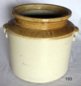 Flagstaff Hill Maritime Museum and Village
Ceramic - Stoneware Container, 1900 to 1940
Stoneware is a rather broad term for pottery or other ceramics that is fired at a relatively high temperature. A modern technical definition is a vitreous or semi-vitreous ceramic made primarily from stoneware clay or non-refractory fire clay. Whether vitrified or not, it is non-porous, it may or may not be glazed. Historically, across the world, it has been developed after earthenware and before porcelain and has often been used for high-quality as well as utilitarian wares. As a rough guide, modern earthen wares are normally fired in a kiln at temperatures in the range of about 1,000°C (1,830 °F) to 1,200 °C (2,190 °F); stoneware's at between about 1,100 °C (2,010 °F) to 1,300 °C (2,370 °F); and porcelains at between about 1,200 °C (2,190 °F) to 1,400 °C (2,550 °F). Historically, reaching high temperatures was a long-lasting challenge, and temperatures somewhat below these were used for a long time. Earthenware can be fired effectively as low as 600°C, achievable in primitive pit firing, but 800 °C was more typical. Stoneware also needs certain types of clays, more specific than those able to make earthenware, but can be made from a much wider range than porcelain. A domestic item used to store food products as glazing makes the container non-porous, often used for pickling. Or larger containers for kitchen flour. Items age is difficult to determine given the same techniques for making stoneware are in use today. Stoneware containers were made by many potteries in Australia and England. They were in common domestic use before plastics were invented around 1940 to store goods so this subject item is probably from around 1900 to the 1940s. Item's significance is difficult to determine given it is not associated with a place, person, historic event, or manufacturer. Its significance lies with its use as a domestic object giving today a view into our social past.Stoneware circular container with wide opening, brown top and off white base. Handholds moulded on each side glazed finish, cracks in base.Noneflagstaff hill, warrnambool, shipwrecked coast, flagstaff hill maritime museum, shipwreck coast, flagstaff hill maritime village, great ocean road, container, stoneware container, kitchen storage, kitchen ware -
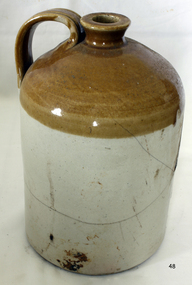
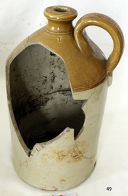
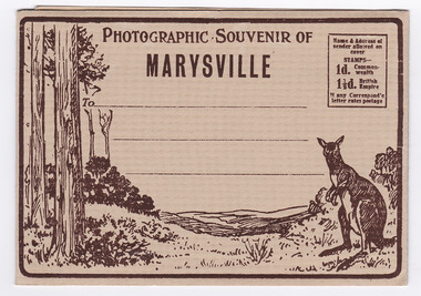 Marysville & District Historical Society
Postcard (item) - Black and white photographs, Barton Bros, Photographic Souvenir of Marysville, 1923-1963
A series of nine black and white photographs of scenic attractions taken in and around Marysville in Victoria that was published by the Barton Bros, Marysville and printed by Valentines Publishing Co as a souvenir of Marysville.A series of nine black and white photographs of scenic attractions taken in and around Marysville in Victoria that was published by the Barton Bros, Marysville, and printed by Valentines Publishing Co as a souvenir of Marysville. Thomas Barton was one of the earliest settlers in Marysville and with 16 children and numerous descendants, the name of Barton is synonymous with Marysville. Thomas John Barton, along with his business partner, Ewen Hugh Cameron, opened a butcher/abattoirs in Marysville in 1864. This was the first shop in Marysville. They supplied meat and other items to the miners along the Woods Point road. Thomas Barton was an active community member and was a key organiser in setting up the school in Marysville in 1870. After Thomas' death in 1911, his sons Fred and Frank took over the family business and renamed it Barton Bros. Name & Address of/ sender allowed on/ cover STAMPS-/ 1d. Common-wealth/ 1 1/2d. British Empire If any Correspond'e/ letter rates postage From Published by BARTON BROS., Marysvillemarysville, victoria, barton bros, acheron way (image 1), keppel's falls (image 2), cumberland falls (image 3), stevenson falls (image 4), taggerty river (image 5), mount margaret (image 6), mount gordan (image 7), nicholl's lookout (image 8), the old ford (image 9), valentine publishing co, souvenir, postcard, thomas barton, ewen hugh cameron, francis adam barton, frederick barton -
 Marysville & District Historical Society
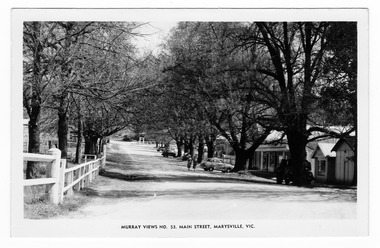
Postcard (item) - Black and white postcard, Murray Views, Murray Views No. 53. Main Street, Marysville, Vic, Post 1929
An early black and white photograph of the main street in Marysville in Victoria.An early black and white photograph of the main street in Marysville in Victoria. This street is now known as Murchison Street. This postcard was produced by Murray Views in Gympie, Queensland as a souvenir of Marysville.POST CARD STAMP REAL PHOTOGRAPH PRODUCED IN/ AUSTRALIA BY MURRAY VIEWS, GYMPIE, Q.murchison street, marysville, victoria, postcard, murray views, souvenir -
 Marysville & District Historical Society
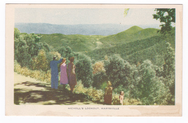
Postcard (item) - Colour tinted postcard, Nucolorvue Productions, Nicholl's Lookout, Marysville, 1950's
An early colour photograph of the view of Marysville in Victoria taken from Nicholl's Lookout.An early colour photograph of the view of Marysville in Victoria taken from Nicholl's Lookout. Nicholl's Lookout is situated on the Marysville-Wood's Point Road. The Marysville-Woods Point Road was originally part of the Yarra Track, constructed in the early 1860s to provide access between Healesville and the Woods Point Goldfields. Despite the steep terrain and engineering difficulties, the Yarra Track soon became a busy route used by pack horses, horse-drawn drays, and wagons. Today this sealed mountain road is a popular scenic drive between Marysville and Warburton. This postcard was produced by Nucolorvue Productions in Elwood, Victoria as a souvenir of Marysville.POST CARD NUCOLORVUE PRODUCTIONS, ELWOOD, VICTORIAnicholl's lookout, marysville, victoria, nucolorvue productions, postcard, souvenir, marysville-wood's point road, yarra track, mining, warburton -
 Marysville & District Historical Society
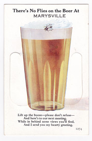
Postcard (item) - Novelty postcard, Valentine Publishing Co. Pty. Ltd, There's No Flies on the Beer At MARYSVILLE, 1940's-1960's
A novelty postcard with pull-out strip of 9 miniature photographs that was produced by the Valentine Publishing Co as a souvenir of Marysville.A novelty postcard with pull-out strip of 9 miniature photographs that was produced by the Valentine Publishing Co as a souvenir of Marysville.There's No Flies on the Beer At/ MARYSVILLE Lift up the booze-please don't refuse-/ And here's to our next meeting./ While in behind some views you'll find,/ And I send you my hearty greeting. 1274 PRINTED PAPER MAILING NOVELTY TO OPEN RAISE FLAP From VALENTINE'S "MAIL NOVELTY" POST CARD COPYRIGHT Printed in Great Britain Tomarysville, victoria, souvenir, crossways cabaret (image 1), taggerty river (image 2), acheron way (image 3), old blacks spur road (image 4), nicholl's lookout (image 5), main street (image 6), sugarloaf bay eildon (image 7), steavenson falls (image 8), cumberland falls (image 9), valentine publishing co, postcard -
 Marysville & District Historical Society
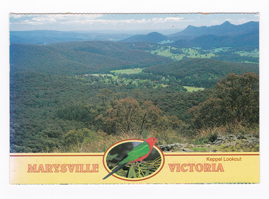
Postcard (item) - Colour postcard, Neil Cutts, Marysville Victoria-Keppel Lookout, Pre 2009
A postcard in a series produced by the Rose Stereograph Company in Victoria, Australia as a souvenir of Marysville.A colour photograph of the view of Marysville in Victoria from Keppel Lookout. Keppel Lookout is named after the Keppel Family who were one of Marysville's earliest pioneering families. The Rose Series postcard No. 3526.POST CARD The "Rose" Series/ De Luxe Proudly Printed in/ Australia Since 1880 AFFIX/ STAMP/ HERE/ Rose Series/ Post Card No./ 3526 ADDRESS/ Nancy Oliver/ 14/150 Tyabb Road/ Mornington/ Victoria 3931/ POSTCODE Keppel Lookout/ MARYSVILLE, VICTORIA, AUSTRALIA/ Photo Neil Cutts Copyright Rose Stereograph Co., Glen Waverley, Victoria (03) 9560 7772 MaryLyn - Marysville/ 10.03.2002 Dear Nancy/ First I want to/ thank you for nice cards/ get well, and others very/ much indeed. We miss/ you not coming here but I hope/ you enjoyed where you went/ Nancy as usual Mary Lyn/ is a nice place to enjoy and/ to feel relaxed and friendly/ in every way. Weather has been/ cool and pleasant with some/ few hot days to enjoy and to/ remind us of summer - not/ many here at/ present more coming./ Our love to/ all we know/ and love to your/ dear self hope/ to see you next/ time Sarina & Eric marysville, victoria, keppel lookout, postcard, souvenir, rose stereograph co, 3526 -
 Marysville & District Historical Society
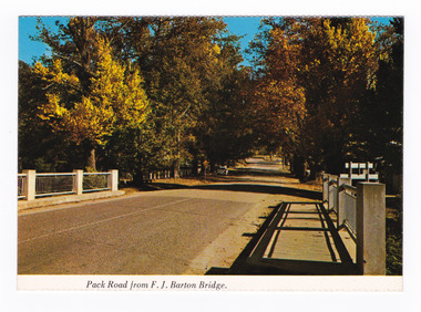
Postcard (item) - Colour postcard, Nucolorvue Productions Pty. Ltd, Pack Road from F.J. Barton Bridge, Pre 2009
A colour photograph of Murchison Street from the F.J. Barton Bridge in Marysville in Victoria.A colour photograph of Pack Road from the F.J. Barton Bridge in Marysville in Victoria. Labeling is incorrect. The view is looking down Murchison Street from the F.J. Barton Bridge. The F.J. Barton Bridge was named after Frederick John Barton. The Barton Family were amongst Marysville's first pioneering families. This postcard was published by Nucolorvue Productions as a souvenir of Marysville.NU-COLOR-VUE/ OF / AUSTRALIA MARYSVILLE, VICTORIA. Pack Road from F.J. BARTON/ BRIDGE. PLACE/ STAMP/ HERE POST CARD NCV.172 - NUCOLORVUE PRODUCTIONS PTY. LTD./ COPYRIGHT Printed in Australiamarysville, f.j. barton bridge, murchison street, victoria, postcard, souvenir, nucolorvue productions, fj barton -
 Marysville & District Historical Society
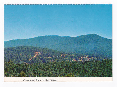
Postcard (item) - Colour postcard, Nucolorvue Productions Pty. Ltd, Panoramic View of Marysville, Pre 2009
A colour photograph of the view of Marysville from Barton's Lookout which is near the Cumberland Valley in Victoria.A colour photograph of the view of Marysville from Barton's Lookout which is near the Cumberland Valley in Victoria. The Cumberland Valley is notable for its giant mountain ash (Eucalyptus regnans) trees within the Cumberland Memorial Scenic Reserve, and relics from former sawmills and gold mining. The Big Culvert is located nearby on the Marysville-Woods Point Road, which was historically part of the Yarra Track. Cambarville, which is in the Cumberland Valley, was established as a timber mill town in the 1940s. Timber mill owners A Cameron and FJ Barton named Cambarville. They established the mill to salvage timber from trees destroyed in the 1939 bushfires. Cambarville was impacted by the 2009 Black Saturday bushfires and any remaining structures were destroyed. Barton's Lookout was named after a member of the Barton Family who were amongst Marysville's earliest pioneering families. This postcard was produced by Nucolorvue Productions as a souvenir of Marysville.NU-COLOR-VUE/ OF/ AUSTRALIA MARYSVILLE, VICTORIA Panoramic View of Marysville from/ CUMBERLAND. PLACE/ STAMP/ HERE POST CARD NUC.171 - NUCOLORVUE PRODUCTIONS PTY. LTD./ COPYRIGHT Printed in Australiamarysville, barton's lookout, victoria, nucolorvue productions, postcard, souvenir, cumberland valley, cumberland memorial scenic reserve, big culvert, marysville-wood's point road, yarra track, mining, timber mills, a cameron, fj barton, cambarville, 1939 bushfires, 2009 black saturday bushfires -
 Marysville & District Historical Society
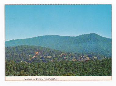
Postcard (item) - Colour postcard, Nucolorvue Productions Pty. Ltd, Panoramic View of Marysville, Pre 2009
A colour photograph of the view of Marysville from Barton's Lookout which is near the Cumberland Valley in Victoria.A colour photograph of the view of Marysville from Barton's Lookout which is near the Cumberland Valley in Victoria. The Cumberland Valley is notable for its giant mountain ash (Eucalyptus regnans) trees within the Cumberland Memorial Scenic Reserve, and relics from former sawmills and gold mining. The Big Culvert is located nearby on the Marysville-Woods Point Road, which was historically part of the Yarra Track. Cambarville, which is in the Cumberland Valley, was established as a timber mill town in the 1940s. Timber mill owners A Cameron and FJ Barton named Cambarville. They established the mill to salvage timber from trees destroyed in the 1939 bushfires. Cambarville was impacted by the 2009 Black Saturday bushfires and any remaining structures were destroyed. Barton's Lookout was named after a member of the Barton Family who were amongst Marysville's earliest pioneering families. This postcard was produced by Nucolorvue Productions as a souvenir of Marysville.NU-COLOR-VUE/ OF/ AUSTRALIA MARYSVILLE, VICTORIA Panoramic View of Marysville from/ CUMBERLAND. PLACE/ STAMP/ HERE POST CARD NUC.171 - NUCOLORVUE PRODUCTIONS PTY. LTD./ COPYRIGHT Printed in Australia Hi There! how are you? fine I hope....Hows school/ treating you?/ Isn't it beautiful now Autumns back again./ You'll have to come up soon and see us, where/ really you/ Ok! it beautiful, the air so fresh and/ clean it makes you want to cry. There are/ so many magnificent and brill marysville, barton's lookout, victoria, nucolorvue productions, postcard, souvenir, cumberland valley, cumberland memorial scenic reserve, big culvert, marysville-wood's point road, yarra track, mining, timber mills, a cameron, fj barton, cambarville, 1939 bushfires, 2009 black saturday bushfires -
 Marysville & District Historical Society
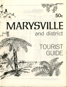
Booklet (Item) - Tourist guide, Ian and Danese Walshe et al, MARYSVILLE and district TOURIST GUIDE, 1982
A tourist guide outlining services, accommodation, activities and places of interest to visit in and around Marysville and the local district.A tourist guide outlining services, accommodation, activities and places of interest to visit in and around Marysville and the local district.marysville, victoria, australia, tourist guide, marysville hotel, castles' store, hawthorne's corner shop, tudor lodge, black spur motel and caravan park, buxton general store, golden fleece roadhouse, marysville garage, burrengeen park, lake mountain, steavenson falls, nanda binya lodge, alpenglow nursery, black spur inn hotel, silver stream trout farm, mccfarlane's grocery, barton's drapery, marysville newsagency, eildon explorer, beauty spot nursery, crossways, pumpernickel, mckenzie's tourist services, blue hills riding school, mountain view horse hire, pitt's garage, maryton park, j l gould sawmill, eildon deer park, eildon weir, maroondah dam, snob's creek, healesville sanctuary, graceburn park, cathedral range, beauty spot walk, tree fern gully walk, michaeldene track, keppel track, woods lookout track, cumberland scenic reserve, cambarville, the big tree, cora-lyn falls, barton's lookout, cumberland falls, sovereign view, wirreanda festival, scenic motel, tower motel, marylands guest house, kooringa guest house, marylyn guest house, mountain lodge, el kanah, marysville hotel motel, buxton hotel motel, black spur inn, buxton caravan park, marysville caravan park, the cumberland, marysville recreation and fun park -
 Marysville & District Historical Society
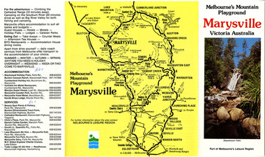
Ephemera (Item) - Tourist Guide, Melbourne's Mountain Playground Marysville Victoria Australia, Unknown
A fold out tourist guide to Marysville and the surrounding district.A fold out tourist guide to Marysville and the surrounding district.marysville, victoria, australia, steavenson falls, marysville golf club, cathedral range, blackwood holiday flats, cumberland holiday inn, kooringa conference and holiday centre, marylyn guest house, marysville caravan park, marysville hotel motel, nanda binya lodge, scenic motel, tower motel, cathedral restaurant, chris's place, danish coffee garden, tudor lodge roadhouse, buxton trout farm, silverstream trout farm, lake mountain ski hire, marysville fun park, mountain view horse hire, jl gould sawmills, marysville dairy, marysville drapery shop, marysville garage, marysville newsagency, top shop -
 Marysville & District Historical Society
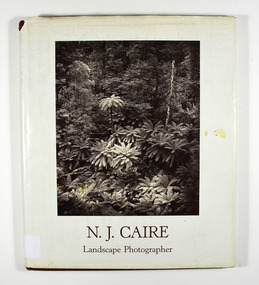
Book - Hardcover book, N.J. Caire Landscape Photographer, 1988
A book of photographs taken by Nicholas John Caire of places and scenery throughout Victoria.A book of photographs taken by Nicholas John Caire of places and scenery throughout Victoria. Photographs by Nicholas John Caire are among the most widely published late nineteenth and early twentieth-century Australian photographs. Between 1875 and 1905 Nicholas Caire travelled the Victorian countryside, looking to capture the scenery for the commercial market. His artistic sensitivity created images which earned him popular acceptance during his lifetime and an enduring place as one of Australia's finest landscape photographers.Hardcover. Front cover photograph-Fairy Scene at the Landslip, Blacks' Spur c1878-9; taken by Nicholas John Caire.For Jane and Clarephotographers, australia, photograpy, landscapes, history, description, travel, views, anne pitkethly, don pitkethly, nicholas john caire, victoria -
 Marysville & District Historical Society
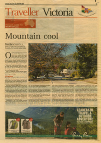
Newspaper (Item) - Newspaper article, The Age, POCKET GUIDE TO MARYSVILLE, 22-11-2008
A newspaper article on Marysville, its local attractions, places to shop and dine, where to stay and ways of traveling to Marysville. This article was published in The Age on Saturday, November 22, 2008.A newspaper article on Marysville, its local attractions, places to shop and dine, where to stay and ways of traveling to Marysville.marysville, victoria, australia, the age, black spur, marysville visitor information centre, steavenson falls, lady talbot drive, taggerty river, keppel falls, phantom falls, beeches rainforest walk, cambarville, yarra ranges national park, the big tree, cumberland walk, lake mountain, steavenson river, acheron river, buxton bait and tackle, marysville trout and salmon ponds, buxton trout and salmon farm, bruno's art and sculpture garden, villa day spa, cathedral view natural therapies, marysville massage, murchison street, village walk, uncle fred & aunty val's old style lolly shop, country touch gallery, manical mechanicals, hidden talent craft gallery, carmyle farm boutique, marysville community market, marysville patisserie, marysville country bakery, fraga's cafe restaurant, terracotta room, marylands country house, the cumberland, mantirri blueberry farm, narbethong, marysville farmers market, the black spur inn, allawah country cottages, barree mud brick cottages -
 Federation University Historical Collection
Document, Zelda Martin, Central Victorian Goldmining towns - Boom Towns or Ghost Towns?, c1996
Zelda Martin was a PhD candidate at the University of Melbourne.[.1] 4th item in light blue display book titled Research Approach/Overview of Chapters/Confirmation of Canditure/Chapters1,2,3&4 of proposed thesis. *Twenty-seven page article on Victorian goldfields towns titled: Central Victorian Goldmining Towns - Boom Towns or Ghost Towns. The article was written during the author's PhD study. It outlines the context methodology, and resources and the chapters of the proposed thesis: (1) Central Victorian Goldmining Towns - The Context (2) Contemporary Views of the Factors Necessary for Town Growth (3) Outward Manifestations of Town Growth (4) The Trappings of Government (5-9) The Main Towns and Their Hinterland. [.2] 5th item in Light Blue display book as above item. *Chapter 1 of proposed thesis titled 'Pick, Shovel and Tin Dish Mining.' Covers in Section A: Central Victoria - Pre 1851: Aborigines in Central Victoria, Squatters, and Government. Section B: The years 1851-1854: The Early Gold Rushes, Government Reaction, Township Surveys, Legislation, Town Development, Local Government and Early Settlement. [.3] 6th item in Light Blue display book as above item. *2A of proposed thesis titled 'Contemporary Views of the Factors Necessary for Town Growth'. Similar information to Chapter 1 plus extra re towns and maps. Sections: Introduction, Context of Place - Geographical Towns Listed, The Context of Time - Pre1851 Aborigines, Governance of Port Phillip, The Squatters, The Villages of Central Victorian Highlands, Conclusion, Condensed Version of Chapter2B. [.4] 7th item in Light Blue display book as above item. *Chapter2B of proposed thesis. Sections: Area of Research, Schools, Banks, Newspapers, Progress Association, Town Development - Sandhurst (Bendigo), Ballarat, Castlemaine,, Maryborough, Ararat and Stawell. [.5] 8th item in Light Blue display book as above item. *Chapter 3 of proposed thesis titled 'Outward Manifestations of Town Growth'. Sections: Introduction, Contemporary Writing, Educationalists, The Bankers, The Townsfolk, Current Theory, General Theories of Urban Development, and Conclusion. [.6] 9th item in Light Blue display book as above item. *Chapter 4 of proposed thesis titled 'Trappings of Government' Sections: Introduction, Early Government Attitudes to Mining and Town Development, Law and Order, Township Surveys, Legislation, Local Government, Transport and Communication, The People and Lobbyists. [.7] 10th item in Light Blue display book as above item. *'The Rise and Fall of Central Victorian Goldmining Towns'. Includes a map showing main Goldfields, a table showing towns and villages at two points in time - 1857 and 1871; a Bibliography of Primary and Secondary Sources. [.8] Resource No1. Black display book titled Local Towns 1 : Alma: *Brief history *Directory *Maps Amphitheatre / Mountain Hut: *Brief History Post Office Directory Ararat: *Brief History *Post Office Directory 1869 - Alphabetical Listing by Occupation *Ararat - Prominent Citizens of 1858 *Langi-Morgala Museum Avoca: *Brief History *Excerpts from 'Avoca The Early Years', Margery and Betty Beavis; pg1 - Beginnings; pg11 - The Midas Touch; pg25 - Local Gold Escorts; pg27 - A Town is Born; pg51- The Administration of Justice; pg53 - The Ways of the Law; pg61 - News of the Day; pg65 - A Time to Play; pg72 - Land Ownership *Post Office Directory (Bailliere's) 1869 *Tourism Map and Information of area *Historic Avoca - A 5.5km Tour *Avoca & the Pyrenees Region - information pamphlet Ballarat: *Early History of Ballarat - Ballarat Historical Society, Publication No.1: origin of the name; Ballaarat - the Beginning; Fabulous Yields from the Ballaarat Goldfield; *Streetscape Lydiard Street. *Hand drawn map showing Leigh River, Old Portland Bay Road, plaque on road to Colac; etc. *Newspaper article re 'The Theatre Royal' ( which stood in the vicinity of the current Owen Williams store) - 'The News'15/04/1998 *Article - 'Ballarat's Mechanics' Institute Lives On' Ballarat Courier, 14/09/1985 *Article - Standing the Test of Time' The News 17/11/1993 re The Mechanics Institute & picture of the Reading Room *'Ballarat a Study of a City, Phyllis Reichl, pub. Nelson, 1968; no.3 place, time and people field studies series *Investigator Vol.33 No.2, 1998 Geelong Historical Society. Article on pg75 describes Ballarat in 1861 *Folded poster - 'Ballarat 100' a history of telegraph communication, pub. Telecom. Beaufort (Fiery Creek): *Brief history *Post Office Directory [.9] Resource No.2 Black Folder Titled Towns cont.No2 Bendigo (Sandhurst): *'Family & Local History at the Bendigo Library - 1851-2001 150 years of gold'. *Bendigo Government Camp in 1853 illustration; key to sketch and names of Government officers stationed there *Excerpts from 'Bendigo and Vicinity' Adolph Haman *The Bendigo Goldfield Registry - pgs 1-7 Introduction *Excerpt: 'Breaking the Grip' *Excerpt: The Most Go-Ahead Place *Excerpts from 'History of Bendigo' - anti license agitation; laying out of town; proposed railway; gold calls and dividends; the Sandhurst Municipality; journalism *Bibliography Blackwood: *Excerpts from 'Aspects of Early Blackwood - The Goldfield, the Landmarks, the Pioneers' Alan J Buckingham and Margaret F Hitchcock, JG Publishing,1980 Buninyong: *A Brief History *Investigator Vol1 No.2 Feb 1966 Geelong Historical Society. Pg3 - Article re gold escort route - Mt Alexander to Adelaide - (see a simple monument on the Western Highway a few miles out of Horsham. Pg 15 - Ballarat Excursion - re the finding of gold. *Three articles published by Buninyong and District Historical Society Inc: (Magpie Exploration; Finding Gold In The Green Hills; Magpie Exploration; Burnt Bridge to Cargarie to Mt Mercer) *Copies of newspaper articles/items *Buninyong Street Directory Carisbrook: *In the Beginning There Was Carisbrook *The History of the Carisbrook Racecourse Carngham / Snake Valley: *Brief History *Directory Castlemaine: *Directory 1865-1866 - Alphabetical and Street *Poster - Castlemaine A Contemporary Guide "The Great Centre" 1866 - A Contemporary Guide to the Fascinating Past *Pamphlet - Castlemaine District Community Hospital *Map - Castlemaine, Maldon & Surrounding Districts *Map and Information - The Dry Diggings Track - a 55kl walk among historic goldfields relics ( Castlemaine Fryerstown Vaughan Mt Franklin Hepburn Daylesford) *Postcard - Former Court House *Directory 1867 - Alphabetical, Trade [.10] Resource No.3 Grey folder Titled Towns 3 Creswick to Maryborough Creswick: *Brief History *Booklet - "Creswick Cemetery Walk" *Booklet - The Buried Rivers of Gold Heritage Trail Creswick *Creswick Historical Museum Information Sheet *Chronological History of Creswick *Alphabetical Directory of the Borough of Creswick *Creswick's Creek Directory 1856 *Historic Creswick Walking Tour *A Brief Account of the Schools of Creswick - Past and Present *100 Years of Railway Travel in Creswick *The Berry Deep Leads *The Spence Home at Jackass Gully in the Creswick State Forest ( William Guthrie Spence - Pioneer) *The New Australian Mine and the 1882 Disaster *Creswick District News, Issue 7, July August 1999 *The Creswick Miners Walk - Information and Map *Maps Chewton: *Brief History *Directory Clunes: *Brief History *Clunes Street Directory Daylesford: *Brief History *Notable Bushfires in Daylesford District Over More Than a Century - "Black Thursday" 1851; 1862; 1899; the Disastrous Hepburn Fire of 1906; 1939; 1944; 1969. *Post Office Directory -Daylesford and Hepburn Dunolly / Inkerman: *Brief History *Directory *Pamphlet - Goldfields Historical Museum *Pamphlet - Historic Dunolly - Victoria's Best Kept Secret *Map of Gold Workings at Dunolly Area - showing where the main gold rushes occurred *Brief History - Inglewood *Directory - Inglewood - Name Occupation, Dwelling Kingower: *Brief History *Directory - Name / Ocupation / Dwelling Linton / Happy Valley / Piggoreet: *Brief History *Directory - Lintons McIvor: *"A History of the Shire and the Township of Heathcote" by J.O. Randell Majorca: *Brief History *Official Post Office Directory 1869 - Name / Occupation/ Address Maldon (Tarrangower): *Brief History Part 1 *Brief History Part 2 *Post Office Directory *List - Alphabetical Order by Names plus Business and Trade (Tarrangower Times Oct/1858) *List - Alphabetical Order by Trade plus Name and Business *Directory - Name / Occupation / Dwelling Maryborough: *Worsley Cottage - built by Arthur Worsley, a contractor in stonework in 1894 [.11] Resource No. 4 Blue Display Book titled Towns 4 Moliagul to Stawell Moliagul: *Brief History *Moligul Legislative Assembly (Voting?) List - Names and Occupations *Moliagul Victorian Post Office Directory 1868 - Name / Ocupation / Address / Comments *"The Welcome Stranger" gold nugget *The Sunday School *The Welcome Stranger Discovery Walk - information and map Moonambel (Mountain Creek) Redbank *Brief History *List of names extracted from advertisments of the Pioneer and Mountain Creek Advertiser 16/02/1861. *Bailliere's Directory 1869 - Alphabetical List of Name / Occupation / Place St Arnaud: *Brief History Sebastapol: *Brief History *Directory 1869 - Alphabetical by Name; plus occupation and address. Browns and Scarsdale: *Brief History *Browns Street Directory - Name and Occupation Smythesdale: *Brief Description *Smythesdale Street Directory -Name and Occupation Stawell (Pleasant Creek) *Brief History *Victorian Official Post Office Directory - Name /Occupation / Dwelling *Chronology - 1841-1920 *Production of gold statistics - 1879 - 1900 *Big Hill *Extracts from "The Golden Years of Stawell". Chapt 1 - Stawell's Coming Out. Capt. 2 - The Gold Rush. Caapt.3 - Cradle of Democracy. Chapt.4 - The Reefs Becomes Stawell. Chapt. 5 - Rushing In. Chapt.6 - The Pioneers. Chapt 7 - The Decade of Optimism. [.12] Resource No. 5: Blue Display Book titled 'Towns Steiglitz to the The Golden Triangle. Steiglitz: Brief History Victorian Post Office Directory 1869 *Map of Steiglitz *List of maps relevant to Steiglitz history *Information 6 tables of data from "Reports of Mining Surveyors Talbot (Back Creek) Brief History Taradale: Post office Directory 1869 - Name/Occupation/Street. Also list in alphabetical order by Occupation Taradale *Chronological Reference to Taradale Mines *Water - The Coliban System of Waterworks *Joseph Brady *The Syphon Tarnagulla (Sandy Creek) *Brief History *Tarnagulla Businessmen Cameos to give depth to advertisments in 'The Tarnagulla Courier' various issues 1864-1871 *Directory - Name/Occupation /Address *List - Name/Business/Trade Wedderburn (Koorong) *Brief History *List - Name/Occupation The Golden Triangle: *The Early Rushes - Wedderburn / Moliagul / Sandy Creek - Tarnagulla / Jones Creek - Waanyarra / Kingower / Dunolly - Goldsborough / Inglweood *Census of 1857 - Population / Occupations *1858-1871 - A Time of Consolidation- Wedderburn / Moliagul / Sandy Creek- Tarnagulla / Arnold *Census 1871 - Population *Information gleaned from the census data - Demographics / Population / Occupations / marital / Birthplace / Religion / Literacy/ Occupation and Housing Cameos *Graphs - Birthplace of settlers /Male-Female Ratio / Married males / Children under 15 as Percentage of Population / Religion *Census 1857 - Statistical data *Maps *Bibliography [.13] Resource No. 6 - Black Display Book Information and Research in Central Victoria including: *Banking - Research from ANZ Bank Archives *Institutions - also includes articles listed from the Ballarat Times Newspaper *Australian mining History Association - A.M.H.A. Bibliography *Australia's Mining History * Bibliography - Land Surveys Victoria - *1853 Administration (Statistics and Other) includes: schools / ministers of religion / police / military / local administration / licences for sale of spirits / distances between various Victorian gold fields. * Victoria Government Gazette (Copy) - N0. 116, 12/12/1854 includes: Gold Felds Commission of Enquiry & No. 85, 15/09/1854 - Addresses presented to the Lieutenant Governor (Sir Charles Hotham) during his tour through the Gold Fields of Victoria,1854. Addresses on behalf of : the people of Bendigo; Members of the Church of England, Bendigo; Members of the Wesleyan Church on the Bendigo Gold Fields; Bendigo Gold District General Hospital; the Bendigo Prospecting Association; Committee of the Bendigo Local Exhibition; Bendigo District Medical Association; Coloured Americans Resident at Bendigo; German Inhabitants of Bendigo; Landowners, Inhabitants, and Miners of Castlemaine; Inhabitants of Forest Creek; Inhabitants of Heathcote and Gold Miners of McIvor; Residents and landholders of the District of Bacchus Marsh; Inhabitants of Kilmore and Vicinity. *Gold Fields Correspondence 1853: letter from Lieutenant Colonel Valiant, (Officer commanding the Troops in Victoria) to the Lieutenant Governor re threatened disturbance at Sandhurst (Bendigo) regarding the Gold License Fee. * Extracts from a book "Victoria" re Gold Fields Commission of Enquiry involving mainly Ballarat and Castlemaine and a chapter titled 'A Tour to the Victorian Gold-Fields' *Lists of central Victorian newspapers - listed by date published 1851to 1874; by first date available to State Library. *A list of cities and towns showing County, population in 1861 &1871, and municipal status. [.14] Resource no.7. Black display book. *Reference: Papers presented to Parliament Victoria - 1859-1860 4 volumes - relevant sections copied. Contains information on Branches of Government. General / Finance / Gold / Gazette / Commission and Warrant / Statistic. *Gold Fields Act. In accordance with the Act the gold fields are divided into six districts - Ballaarat, Castlemaine , Sandhurst, Avoca, Ararat, and Beechworth.. Official staff in each gold district consists of a Resident Warden, Wardens, Wardens' Clerks, Bailiffs, Chinese Protectors, Chinese Interpreters, and Mining Surveyors. *Gold Receiver *Gaols *Police magistrates and Clerks of Petty Sessions, etc. *Field Branch *Immigration and Emigration Overland - Chinese - 1859 *Population on the Goldfields *The Geological Survey - The Government Geologist is assisited by staff from four branches - the office Branch; the Publishing Branch; the Field Branch and the Museum Branch. *Commission to Enquire Into Sludge dated 10/02/1859 (Some sections copied) - Report to the Honorable Chief Commissioner of Public Works, Melbourne re the mode of carrying the sludge from the puddling mills in Sandhurst without interfering with the drainage of the town and the roads in the neighbourhood. [.15] Resource No.8: Camel display book titled Resource No. 8. Aborigines *Lists of book titles - +"Readings in Victorian prehistory" +"The Aborigines of Port Phillip" +Aboriginal languages and clans" +"A History of the Port Phillip District" +"Langi Ghiran 1: Aboriginal Rock...." +"Koorie History: sources for aboriginal studies in the State Library of Victoria", ed. Tom Griffiths, Melb. Friends of the State Library, 1989 +"The Public Lands of Australia Felix"; settlement and land appraisal in Victoria1834-91 with special reference to the Western Plains", J.M.Powell, Melb. Oxford University Press 1970 +*Bibliography of the Victorian Aborigines' from the earliest manuscripts to 31st December 1970, Massoa, Aldo, Melb. Hawthorn Press, 1971 +"Aborigines in Colonial Victoria, 1836-1886", M.F. Christie, Sydney University Press, 1979 +"Urban and Industrial Australia: readings in Human Geography" ed J.M. Powell, Melb. Sorrett Pub. 1974 *Extracts: -Processes of Pioneer Settlement - The Squatting Occupation of Victoria, 1834-60. J.M. Powell -Areal Variations in the Class Structure of the Central-Place Hierarchy. P. Scott - Volume1 and Volume 2: Notes Relating to the Habits of the Natives of Other Parts of Australia and Tasmania. Compiled from various sources for the Government of Victoria by R Brough Smyth. John Curry, O'Neil, Melb. 1st pub. Melb. 1876. p31-45 - Numbers and Distribution of the Aborigines in Victoria -Victorian Aborigines 1835-1901 - A Resource Guide to the Holdings of the Public Record Office, Victoria; published by the Government Information Centre 1984. *History of the Aboriginal Artefacts Displayed in the Daylesford Museum. F. G. Powell (4 page pamphlet) *Letter to Zelda Martin from Peter Lovett, Cultural Officer, Ballarat & District Aboriginal Co- Operative, 05/02/1997 *Map: Ian Clarke Victorian Tribunal Boundary Map - Clans of Central Victoria. *Victorian Rock Art and Mythology - Article about Mount Langhi Ghiran and myths of the Tjapwarong people. *Two Aboriginal myths relating to the Grampians - 'The Monster Emu' / 'The Aquisition of Fire', by the Aborigines in the Grampians Areas *Article titled (chapter 8) Ballarat - information re camping sites in the region. Lake Wendouree / Lake Burrumbeet (includes a myth) / Mt Bunninyong / Lal Lal / Pitfield / Mount Elephant / Mount Egerton / Meredith / Lake Goldsmith / Lake Learmonth / Ercildoune *Notes on the Aborigines of the Wider Ballarat Region plus European names=Aboriginal names. John Morris 26/07/1995 *Role of Aborigines in Town Development in Central Victoria. Mentions Native Police Force est. in Port Phillip 1842 and Central Board for Aborigines est. 1860 *The Grave of King Billy. (Frank Wilson) Pamphlet. *Camping Places in Central and Northern Victoria. Article re Lake Burrumbeet site. *Programme for the Unveiling of Memorial Cairn for Edward Stone Parker 1802-1865. Note portrait not accurate. Accurate portrait is available in the book "A Successful Failure A Trilogy The Aborigines and Early Settlers", Edgar Morrison, Graffiti Publications, 2002. * Large envelope addressed to Mr G Netherway containing newspaper cuttings regarding the life of Edward Stone Parker, the unveiling of the Memorial Cairn as mentioned above, articles titled 'Episodes from Our Early Days' (Edgar Morrison, Yandoit)- The Black's School, A School At Last and The Final years. Also a typed page titled 'Historical Background to E.S.Parker's Career. Includes an interesting tale titled 'When the cat lay doggo' re laying power leads for the unveiling ceremony at the memorial site. [.16] green display folder titled 'Research Aids' *List of references to Commissioners' & W'ardens' Reports (formerly held at La Trobe Library Archives, now at Public Records Office [PRO]). Indicates town referred to / date of report / name of camp if different to town. * Archive information re Anglican Records *Movement around the Goldfields - Miners and Storekeepers - usefulness of newspapers in providing information - areas covered - Castlemaine, Maldon, Ararat, Stawell, Tarnagulla, Dunolly. *Port Phillip /Victoria Directories 1839/1867 - Chronological list of Directories included in this series. *"Notes on the History of Local Government in Victoria" A.W. Greig Melb. University Press 1925 - Photo-copied extract p5-p40. (Source - Deakin University Library) - Introduction by W.Harrison Moore. Section 1 - Development in New South Wales Before Separation. Section 2 - Development in Victoria After Its Separation from New South Wales. Hand written notations: 'roads, markets, and local government 1855 on' ;'opportunity of squatters in parliament' and 'opportunities of matters in parliament p33' * Notes on the Establishment of Surveyor General's Department 1851and Commissioner of Crown Lands and Survey. * Newspaper articles from The Argus, 1849, re the discovery of gold in the Pyrenees region. * Excerpt - a report on schools - A.B.Orlebar, Inspector; re the need for permanent school buildings rather than tents. *Excerpt from - 'Approaches to Urban History', Sean Glynn: The Case for Caution * Except from - 'The Urban Sprinkle', Weston Bate: Country Towns and Australian Regional History *Reference- 'The History of Land Tenure in the Colony of Victoria', John Quick. References the Haines Land Bill, land tenure and Land Leagues. [.17] Light blue envelope folder titled 'Birtchnell's Ballarat, etc. Directory 1862 *Contains various directories for Smythesdale, Buninyong, Clunes, Brown's and Creswick. [.18] Red envelope folder no.2 titled Victorian Gazetteer *Selected pages from 1869 Victorian Gazetteer on A4 paper (with a handwritten note questioning if some pages are from 1868 Victorian Gazetteer as appears to be different sizes - A3 pages.) Information includes locations and descriptions of towns, hotels, banks, communications and populations. (Does not include names, residences and occupations) [.19] Red Envelope folder titled Bailliere's Official Post Office Directory 1868 (or1869 or a mixture of both?) *Preface *Contains a selection of pages of towns highlighted in yellow in the the index *Work on this directory was commenced in 1867. *Information includes: Municipalities - mayors and councilors; lists of towns naming male inhabitants and their occupations. [.20]Yellow manila folder titled Post Grad Seminar Presentation 1996 *Gives some background to Zelda Martin's proposed thesis and why she chose the topic Gold Mining Towns Boom or Bust [.21] A3 display book - No. 1A * A list of 'Relevant Newspapers collected: The Tarrangower Times and Maldon Advertiser (first published 1858) Includes dates 1858-1867. The Mount Alexander Mail. Includes dates 1854-1866 The Tarnagulla Courier. Includes dates from1864-1871 Dunolly and Burnt Creek Express. Includes dates from 1862-1871 * Selection of newspaper pages from The Mount Alexander Mail 1854 to 1856, mostly showing advertisements for businesses and services provided to that community. [.22] A3 display book - No. 1B * Selection of newspaper pages from The Mount Alexander Mail 1857 to 1866, mostly showing advertisements for businesses and services provided to that community. [.23] A3 display book -No. 2 * Selection of newspaper pages from The Tarnagulla Courier 1864 to 1871, mostly showing advertisements for businesses and services provided to that community. [.24] A3 display book - No. 3 *Selection of newspaper pages from The Tarrangower Times (and Maldon and Newstead) Advertiser 1858 to1867, mostly showing advertisements for businesses and services provided to that community. [.25] A3 display book - No.4 * Selection of newspaper pages from The Dunolly and Burnt Creek Express; and The Dunolly and Betbetshire Express 1862 to 1871, mostly showing advertisements for businesses and services provided for that community. [.26] A3 display book - No.5 Includes: * Bryce Ross's Diggings Directory. Includes instructions for using this directory. This directory was used by "all persons having connexion or desiring to communicate with 'working parties, private friends, or Stores at the Diggings." As a directory for each area wwas completed it was published in each month's issue of Bonwick's "Digger's Magazine." Years c1852/1853. This Directory commences first at the head of Forest Creek. Includes a directory for Bendigo and Ballarat. Of interest at the end of the Bendigo and Ballarat directory is a list of the number of storekeepers, butchers, doctors, smiths, eating houses, lemonade sellers and chapels. * The Castlemaine Directory and Book of General Information Comprehending Glass's Model Calendar for the Two Years 1862 and1863. "zelda martin, victorian goldfield towns, bendigo, castlemaine, ballarat, maldon, stawell, ararat, maryborough, creswick, avoca, heathcote, banks, bank of australasia, union bank of australia, government camp, sandhurst, water supply, tarnagulla, talbot, back creek, mountain creek, police court, carisbrook, dunolly, thompson's foundry, charles clacy, anthony trollope, robert cecil, mount alexander, urbanisation, national schools, education, govenrment, industry, railway, transport, settlement, land settlement in central victoria, steiglitz, joseph brady, the new australian mine, berry deep leads, william guthrie spence, creswick state forest, arthur worsley, worsley cottage, the welcome stranger, moliagul, moonambel, redbank, st arnaud, sebastapol, brown's, scarsdale, clunes, chewton, daylesford, bushfires, inkerman, inglewood, kingower, lintons, happy valley, piggoreet, mcivor, majorca, tarrangower, taradale, the coliban system, the syphon, sandy creek, wedderburn, koorong, arnold, jones creek, waanyarra, the golden triangle, census 1857, blackwood, buninyong, durham lead, magpie, carngham, snake valley, alma, amherst, daisy hill, amphitheatre, mountain hut, beaufort, fiery creek, counties, population, gold fields commission of enquiry1854, william westgarth, gold license fee, lieutenant colonel valiant, administration of the victorian gold fields, commission to enquire into sludge 1859, e.s. parker, edward stone parker, edgar morrison, mount franklin protectorate, dja dja wurrung, memorial cairn, franklinford, mt franklin memorial cairn, jajowurrong, dja dja wurung, tjaowarong, wothowurong, assistant protectors, daylesford museum, buluk, rock art - grampians, aboriginal mythology - grampians, aborigines, first nations people, mount franklin, aboriginal artifacts, lake burrumbeet, native police force, central board of aborigines, yandoit, commissioners' reports, wardens' reports, port phillip/victoria directories 1839-1867, local government - victoria 1853/1854, surveyor general's department - 1850's, victorian schools 1850's, a.b.orlebar, haines land bill, william charles haines, wilson gray, land tenure, land leagues, victorian gazetteer, the tarrangower times and maldon advertiser - 1858-1867, the mount alexander mail 1854-1866, the tarnagulla courier 1864, dunolly and burnt creek express 1862-1871, bryce rose's diggings directory, the castlemaine directory 1862-1863 -
 Eltham District Historical Society Inc
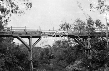
Photograph, Hurst's Bridge, c.1912
The area of Hurstbridge was originally known as Hurst’s-bridge after the timber bridge built over the Diamond Creek near Hurst’s station in late 1881/early 1882 on Hurstbridge-Arthurs Creek Road, Hurstbridge. It was built by John McDonald, of Arthur's Creek and was demolished and replaced in 1917 by a reinforced concrete arch bridge designed by John Monash. Part of a slide show presentation "Bridges & Waterways of the Shire" by Russell Yeoman to the 13 September 1989 Society meeting. The presentation included slides of historic photos from the Shire of Eltham Pioneers collections as well as several recent views. This photo forms part of a collection of photographs gathered by the Shire of Eltham for their centenary project book, Pioneers and Painters: 100 years of the Shire of Eltham" by Alan Marshall (1971). The collection of over 500 images is held in partnership between Eltham District Historical Society and Yarra Plenty Regional Library (Eltham Library) and is now formally known as 'The Shire of Eltham Pioneers Photograph Collection.' It is significant in being the first community sourced collection representing the places and people of the Shire's first one hundred years.Digital imageshire of eltham pioneers photograph collection, 1912, bridge, diamond creek (creek), hurstbridge, hurst's bridge -
 Eltham District Historical Society Inc
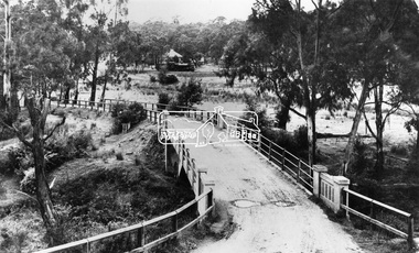
Negative - Photograph, View across bridge at Hurstbridge, Vic, c.1922
View across the new Monash bridge across the Diamond Creek at Hurstbridge looking towards the township, note steam train in centre background of image. Dated between the opening of bridge Nov. 1917 and provision of electric rail service Aug. 1926 - c.1922. Part of a slide show presentation "Bridges & Waterways of the Shire" by Russell Yeoman to the 13 September 1989 Society meeting. The presentation included slides of historic photos from the Shire of Eltham Pioneers collections as well as several recent views.This photo forms part of a collection of photographs gathered by the Shire of Eltham for their centenary project book ,"Pioneers and Painters: 100 years of the Shire of Eltham" by Alan Marshall (1971). The collection of over 500 images is held in partnership between Eltham District Historical Society and Yarra Plenty Regional Library (Eltham Library) and is now formally known as 'The Shire of Eltham Pioneers Photograph Collection.' It is significant in being the first community sourced collection representing the places and people of the Shire's first one hundred years.Digital image 4 x 5 inch B&W Negshire of eltham pioneers photograph collection, hurstbridge, bridge, steam train, diamond creek (creek), railway line, monash bridge