Showing 943 items
matching watt
-
 Bendigo Historical Society Inc.
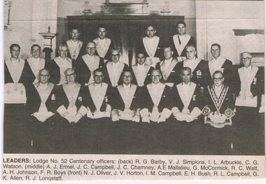
Newspaper - JENNY FOLEY COLLECTION: LEADERS
Bendigo Advertiser '' The way we were'' from 2002: Leaders: Lodge No. 52 Centenary officers - Back: R. G. Barby, V. J. Simpkins, I. L. Arbuckle, C. G. Watson. Middle: A. J. Ermel, J. C. Campbell, J. C. Chamney, A. E. Mallalieu, G. McCormick, R. C. Watt, A. H. Johnson, F. R. Boys. Front: N. J. Oliver, J. V. Horton, I. M. Campbell, E. H. Bush, R. L. Campbell, G. K. Allen, R. J. Longstaff. The clip is in a folder.newspaper, bendigo advertiser, the way we were -
 Bendigo Historical Society Inc.
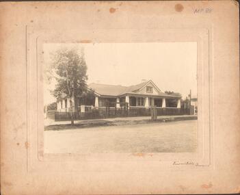
Photograph - LARGE EDWARDIAN STYLE HOUSE ON CORNER BLOCK
Black and white photograph on embossed card. Large Edwardian? Style house on corner block. Gable roof with attic in front. Bay windows under return verandah with concrete rendered supports, decorative brick work on balustrade. Picket fence with lattice on top. Pergolas over gates. Inscriptions on front - 'Vincent Kelly, Bendigo'. On back - 'Knights/front view', TC Watts & Son, Auctioneer, Estate Agents, Imperial Fire Office. Beehive Chambers, Pall Mall, Bendigo' (rectangular decorative stamp on back). 'Royal Historical Society of Victoria, Bendigo Branch (circular stamp).buildings, residential -
 NMIT (Northern Melbourne Institute of TAFE)
Photograph album: CTC 1978, Photograph album of Special occasions at Collingwood Technical College 1978
Photo album with an European City scene on the cover. Label on the spine 'Special occasions at CTC'. Photos date from 1978 and include Joe Barberis, Ian Scott, Bert Eastman, Harry Rothwell’s retirement dinner, Len Watts, Colin Ferris, Trevor Cook, Warwick White, George Thomas, John Roberts, Jim Hunter, Bill Fletcher, John Barry, Laurie Bayley, Bill Moore, Jim Hartney, David Mitchell, Cliff Ashworth, Ron Ritchie, Bill Roebuck, Ruth Kerr, Bev Attwater, Elaine Parsons, JDHarris awards, John King, Mike Heverin.collingwood technical college, staff, presentations, nmit -
Glen Eira Historical Society
Letter - Caulfield Common School
There are two documents of correspondence covering a brief history and the establishment in 1863of Caulfield Common School, Glenhuntly Road. 1.The first is a photocopy of a hand written letter with attachments to thr Board of Education dated 16/03/1864 from T.W. Watts (Hall of Commerce). The attachment gives more detail about the history and establishment of the Caulfield Common School. 2.The second document is a photocopy of the school’s correspondence from 1865. The third document is an article from Melbourne Weekly Bayside 09/05/2012. It is about the Caulfield Primary School which was originally Caulfield Common School, the article has a short history of the school.webb george h.f., franas richard, watts t.w. mr., chambers mr., cummins mr., stephen mr., topp mr., cowie mr., lewis mr., mcfarland mr., miller mr., renwick mr., poole w. rev., caulfield, glen eira road, glen huntly road, glenhuntly road, croton hurst, caulfield common school, caulfield combined school, caulfield union chapel school, church of england school, caulfield union chapel, church of england, schools, schoolhouses, independent schools, school committees, committee of management, caulfield road board, chapel school committee, church of england school committee -
 Orbost & District Historical Society
folder, Orbost Bridges - Snowy River Road Bridges, 1974 1976
This folder was compiled in October 2015 from documents, magazines. papers and photographs donated by David Jellie, engineer in charge 1974 - 1976. In early 1974, as an Engineer with the Country Roads Board, David came to Orbost as the Supervising Engineer for the construction of the new bridges which were part of an 8.4km Orbost bypass road design. This was a major project involving not only a new bridge over the Snowy River (including Lochiel Lagoon), but other bridges over Ashby’s Gulch and Watt’s Gulch. These new bridges were opened in November 1976 with the unveiling of a plaque on the eastern end of the $2.4M Snowy River Bridge. (ref. May Leatch)This item is a useful reference tool on the construction history of the Snowy River Road bridges.A white plastic folder - Orbost Bridges - Snowy River Road Bridges. it contains newspaper articles, booklets, photographs and documents relating to the construction of the Snowy River Road Bridge in 1974 -1976.on front cover - 1974 - 76 ORBOST / SNOWY RIVER ROAD BRIDGES * construction * photos * articles * plans Donated by David Jellie Oct 2015snowy-river-bridges jellie-david -
 Orbost & District Historical Society
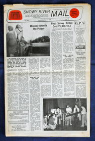
newspaper, Snowy River Mail, 1.12.1976
In early 1974, as an Engineer with the Country Roads Board, David came to Orbost as the Supervising Engineer for the construction of the new bridges which were part of an 8.4km Orbost bypass road design. This was a major project involving not only a new bridge over the Snowy River (including Lochiel Lagoon), but other bridges over Ashby’s Gulch and Watt’s Gulch. These new bridges were opened in November 1976 with the unveiling of a plaque on the eastern end of the $2.4M Snowy River Bridge. The new bridge, built by the CRB at a cost of $2.4 million, is 1.6 metres above the record flood levels of 1971. (ref. May Leatch) This newspaper contains contemporary reports of a significant event in Orbost.A Snowy River Mail newspaper, dated 1.12.1976. It contains news articles, photographs and advertisements. The main article relates to the official opening of the Snowy River Bridge and the unveiling of a plaque on the eastern approach. It also contains a history of the first Snowy River Bridge.snowy-river-bridge orbost-bridges snowy-river-mail -
 Forests Commission Retired Personnel Association (FCRPA)
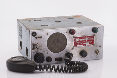
Radio set
After the 1939 bushfires, the Forests Commission invested heavily in a radically new communications network. After suffering some inevitable delays due to the War, radio VL3AA switched into full operation in October 1945 proudly beaming out 200 watts across the State. The communication systems were regarded at the time to be more technically advanced than the police and the military. These pioneering efforts were directed by Geoff Weste, and later technical experts like Rex Philpot, John Whitehead, Charlie Reisinger and many others who designed, built and repaired most of the radio equipment. There was a dedicated radio laboratory at Surrey Hills in Melbourne.Radio setManufactured by McLeod Electric - Derrinallumradios, forests commission victoria (fcv) -
 Forests Commission Retired Personnel Association (FCRPA)
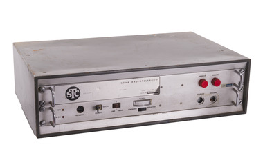
Radio set, STC Star Radio Telephone
After the 1939 bushfires, the Forests Commission invested heavily in a radically new communications network. After suffering some inevitable delays due to the War, radio VL3AA switched into full operation in October 1945 proudly beaming out 200 watts across the State. The communication systems were regarded at the time to be more technically advanced than the police and the military. These pioneering efforts were directed by Geoff Weste, and later technical experts like Rex Philpot, John Whitehead, Charlie Reisinger and many others who designed, built and repaired most of the radio equipment. There was a dedicated radio laboratory at Surrey Hills in Melbourne.Radio setSTC Star Radio Telephone Type FR5.1.25-STradios, forests commission victoria (fcv) -
 Bright & District Historical Society operating the Bright Museum
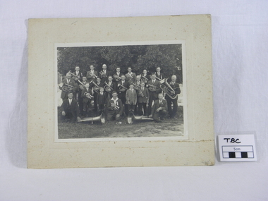
Photograph, Wandiligong Band sepia, Wandiligong Band, 1929
Photograph taken at the time of the Back to Bright Celebrations 1929-1930. Unveiling of the Clock Tower in Mafeking Square,Bright, as a memorial to the fallen of the Boer War and World War 1. One of the tubas in the photograph is included in the Bright Historical Society collection.External photograph of the Wandiligong Brass Band. Backdrop of large tree. 22 male members with their instruments, no drums shown.Reverse of the photograph: Top Row J Stephens, A Simmonds L.Bennett F Matthews B Stephens N.Williams A.Smith/2nd. A Watters M Matthews S Stephens W Stephens G Chalwell B.Gribble R.Goldsworthy. R B Stephens/Front. W.Williams H Williams C.Williams T.Williams A.Williams L.Williams S.Smith/ Back to Bright. 1929 -1930 R Goldsworthy photograph, brass band, wandiligong, back to bright, 1929 1930, r goldsworthy, musical instruments -
 Bendigo Historical Society Inc.
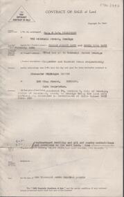
Document - H. A. & S. R. WILKINSON COLLECTION: CONTRACT OF SALE
Contract of sale of land dated 5th February, 1957 between Mr. D. J. & Mrs. D. N. Watt (vendor) and Mr. A.H. Pappos (purchaser) Solicitor for vendor: Hogan & Hogan, Bendigo. Solicitor for purchaser: Hogan & Hogan, Bendigo. Property: piece of land being allotment 78 section C land described in certificate of title volume 3657 folio 393, together with weatherboard dwelling and all sundry outbuildings and erections on the said land, also all linos, blinds and light fittings and shades. Price 1,700 pounds. Attached statement pursuant to section 34 of the estate agents act, 1956.organization, business, h.a. & s.r wilkinson real estate -
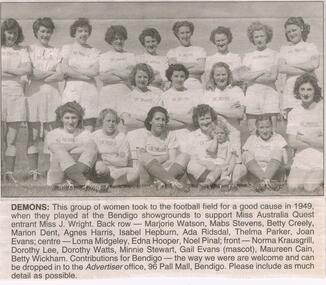 Bendigo Historical Society Inc.
Newspaper - JENNY FOLEY COLLECTION: DEMONS
Bendigo Advertiser "The way we were" from Wednesday, July 18, 2004. Demons: this group of women took to the football field for a good cause in 1949, when they played at the Bendigo showgrounds to support miss Australia Quest entrant Miss J. Wright. Back row: Marjorie Watson, Mabs Stevens, Betty Creely, Marion Dent, Agnes Harris, Isabel Hepburn, Ada Ridsdal, Thelma Parker, Joan Evans. Centre: Lorna Midgeley, Edna Hooper, Noel Pinal. Front: Norma Krausgrill, Dorothy lee, Dorothy Watts, Minnie Stewart, Gail Evans (mascot) Maureen Cain, Belly Wickhamnewspaper, bendigo advertiser, the way we were -
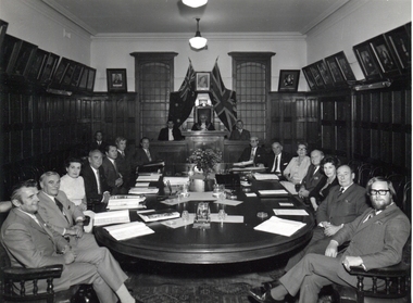 Ballarat Heritage Services
Photograph - Photograph - Black and White, City of Kew Councillors at the last Meeting in the Kew Town Hall, Walpole Street, c1972
The former Kew Town Hall was used for an Op Shop for a number of years before it was demolished for a supermarket.City of Kew Councillors at the last Meeting in the Kew Town Hall, Walpole Street. Left to right going around the table: Cr Dick Cremin, Cr Ivan Wade, Cr Dorothy Buchanan, Cr Jack Ryan, Cr George McKenzie , Cr Gerard Petrie, Cr Jack Gervasoni, behind these councillors sits Brian Robinson, Laurie Johnson (Town Clerk), Cr Leo Hawkins (Mayor), George Russell (City Engineer) , ?, ?, Cr Gladys "Bon" Fink, [possible Cr Percival "Percy" Watts?]' Cr Phyllis Hore, [Possibly Cr Frank O'Brien?], Cr Alan Hutchisoncity of kew, councillors, kew town hall, dick cremin, ivan wade, jack ryan, gerrie petrie, jack gervasoni, john hogan gervasoni, alan hutchinson, gerard petrie, jack ryan, george mckenzie, brian robinson, laurie johnson, leo hawkins, george russell, gladys "bon" fink, bon fink, percival watts, phyllis hore, frank o'brien -
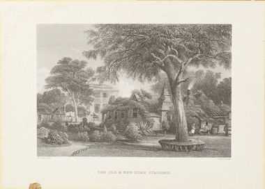 Wangaratta Art Gallery
Print, Arthur Willmore et al, The Old & New Home Stations, Victoria (Bontharambo, Wangaratta), 1873-1876
This etching by British engraver Arthur Willmore was created from Russian born artist Nicholas Chevalier’s original watercolour landscape of Bontharambo, Wangaratta (Chevalier’s watercolour is held in the collection of the National Library of Australia). Chevalier moved to Australia during the Colonial period and is famous for his landscape paintings, which were most commonly commissioned by wealthy landowners or merchants wanting to record their material success. Bontharambo is a historic property located in Wangaratta which was made famous by pastoralist Joseph Docker who took up the Bontharambo run in 1838 and has remained in the family since. The historic homestead on the property was built between 1857-1859 and was designed by architect Thomas Watts.ColonialWangaratta Art Gallery CollectionA rectangular landscape etching of the homes on Bontharambo station printed in black ink on off-white paper.Obverse: N. Chevalier/ A. Willmore/ THE OLD & NEW HOME STATIONSwangaratta art gallery, arthur willmore, nicholas chevalier, bontharambo, wangaratta -
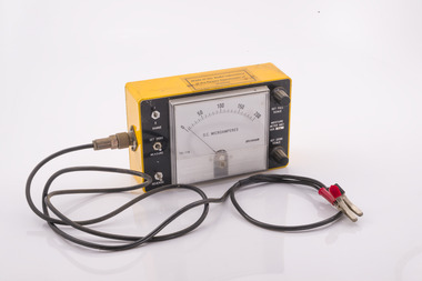 Forests Commission Retired Personnel Association (FCRPA)
FCV testing meter
After the 1939 bushfires, the Forests Commission invested heavily in a radically new communications network. After suffering some inevitable delays due to the War, radio VL3AA switched into full operation in October 1945 proudly beaming out 200 watts across the State. The communication systems were regarded at the time to be more technically advanced than the police and the military. These pioneering efforts were directed by Geoff Weste, and later technical experts like Rex Philpot, John Whitehead, Charlie Reisinger and many others who designed, built and repaired most of the radio equipment. There was a dedicated radio laboratory at Surrey Hills in Melbourne. The purpose and operation of this particular instrument is unknown.FCV testing meterMade in the radio laboratory of the Forests Commission Victoriaradio, forests commission victoria (fcv) -
 Eltham District Historical Society Inc
Document - Property Binder, 846 Main Road, Eltham
Photocopy Newspaper Article: An old grain store faces a new role; Diamond Valley New, Tuesday, February 11, 1986, p13 (donated Geoff Watt28/2/2023). Photocopy Letterhead: Watt + Partners Pty Ltd, Architecture, Project Management (donated Geoff Watt28/2/2023). Photocopy Heritage Assessment: Former Grocer's Shop, 846-848 Main Road, Eltham by Graeme Butler & Associates, 1997. Newspaper article: Diamond Valley News, 16 July, 1997 Funeral parlour gets permit. Newspaper advertisement: Leader Associated Newspapers, Eltham Centenary Supplement, March 30, 1971, Eltham Produce Storemain road, eltham, property, shops, businesses, charles cockroft, edna brown, don brown, c r nicholls, josiah holloway, john holloway, samuel holloway, robert galagher, john wright, anne hunniford, a g cole, eltham produce store -
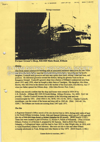
 Eltham District Historical Society Inc
Photograph, Primary, Eltham Christian School, 1984, 1984
ROW 2 L -R: David Prentice, Jessica Doedens, Jackie Levering, Darren Watts, Fiona Berry, Karen Whalley, ROW 1 L - R: Rachel Berry, Andrew Mitton, Natasha Watts, Peter Whalley, Marissa Vail, Aaron Mitchell, Teacher: Mrs. Humphreys Class: PRIMARY The Stokes family settled in this area of Eltham in the 1940s and were associated with the Eltham Christian Church. In the 1970s this church had met in temporary premises in Eltham. Lots of the original 1920s subdivision remained south of Nyora Road and a number of these lots were utilized for the Eltham Christian School, which was established by the Eltham Christian Church in 1981. The school operated on this site until 2000. The premises were owned by the Nillumbik Community Church who were in operation till November 2010 when the Eltham Baptist Church commenced a lease arrangement until the site was purchased by them in April 2012. The building is constructed of brick and timber with a balcony on two sides that looks over an expanse of grass. Sources: STOKES ORCHARD – AN INCOMPLETE HISTORY February 28, 2015 http://www.elthamhistory.org.au/ Australian Christian Church Histories - Eltham Baptist Church http://www.churchhistories.net.au/church-catalog/eltham-vic-baptist/ From a magnetic spiral bound photo album featuring a series of photographs (some cropped) with captions relating to the staff, students and activities of the Eltham Christian School which operated as part of the Eltham Christian Church at Nyora Road, Eltham. See also entries for each photograph.Colour Photographeltham christian school, nyora road, david prentice, jessica doedens, jackie levering, darren watts, fiona berry, karen whalley, rachel berry, andrew mitton, natasha watts, peter whalley, marissa vail, aaron mitchell, mrs humphreys -
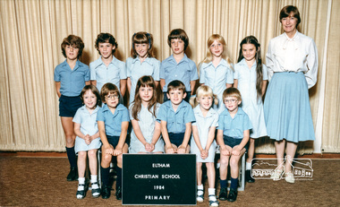
 National Vietnam Veterans Museum (NVVM)
Photograph, Ultimate Surfing Wagon
Photograph of two young soldiers in black shorts on top of a n APC with a surf board at the beach at Vung TaliON BACK Vietnam 1966/67 1st APC Squadron 3 Cavalry Reg. "I consider this to be the ultimate surfing wagon. This Armoured Personnel Carrier was down at Vung Tan for repairs so the opportunity for a surf was taken with borrowed boards from the US Base. 20A was Lt Ross (Bluey) Guymeis carrier, driven by Tony Walsh. Later it became David Watts, driven by Max Nicholsonphotograph, vung tan, armoured personnel carrier -
 Whitehorse Historical Society Inc.
Equipment - Otiscope, Slide Projector
In one place in records Pat Faggetter is credited with the donation of this item. It would appear that Pat picked it up from Mrs Coldrey so I have credited Mrs Coldrey as the donor. See also page 10 of green folder. (Ted Arrowsmith)OTICISCOPE An early slide projector. Large, black square unit with chrome parts. Bellows to assist in focus can be slid up to 26cm. On the end of the bellows is screwed a further adjustable lens (8.5cm diam by 11cm long). The body of the unit can be tilted to focus on the screen. This lens is endorsed '8 inch (26cm) high focus Aldus UNO Projector Lens'.This lens and a lamp is stored inside the projector. The projection lamp is an Osram (balloon shaped) patent registered 260 volt Gas Filled 500 watt 51. Made in England. Screw fitting .Power supply is by early English type two pin plug with a toggle switch on left side.Ensign Optiscope No. 6 - Made in Britain - Ensign Ltd - London.photography, projectors -
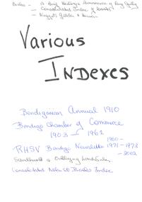 Bendigo Historical Society Inc.
Article - Various Indexes
Collection of indexes - Business advertisements St Patrick's Annual Sports 1934; White Hills Residents 1907-1908; Business Advertisements from Directories 1865, 1872, 1875, 1904, 1907, 1910; Bendigo Chamber of Commerce 1903, 1913, 1920, 1946; TC Watts 1920s photos of house sales; Back Creek Bendigo Cemetery - First Year Burials; Wills administered by Sandhurst Trustees; 1842-1866 277 Mining Deaths from Inquet records for Sandhurst; The Bendigonian Annual 1910. Compiled by Carol Holsworth. Collection is in plastic pockets, contained in a white A4 three ring binder. Fourteen plastic pockets in total. st patrick's annual sports, bendigo businesses, white hills residents, bendigo chamber of commerce, house sales, t.c.watts, back creek cemetery, sandhurst trustees, mining deaths, the bendigonian -
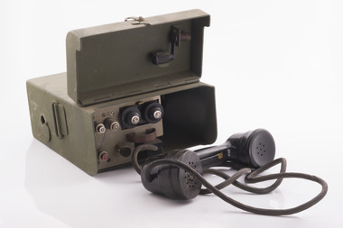 Forests Commission Retired Personnel Association (FCRPA)
Radio Telephone with handset
After the 1939 bushfires, the Forests Commission invested heavily in a radically new communications network. After suffering some inevitable delays due to the War, radio VL3AA switched into full operation in October 1945 proudly beaming out 200 watts across the State. The communication systems were regarded at the time to be more technically advanced than the police and the military. These pioneering efforts were directed by Geoff Weste, and later technical experts like Rex Philpot, John Whitehead, Charlie Reisinger and many others who designed, built and repaired most of the radio equipment. There was a dedicated radio laboratory at Surrey Hills in Melbourne. Little is known about this particular radio handsetField radio telephone with handset.radios, forests commission victoria (fcv) -
Glen Eira Historical Society
Document - Glenfern
This file contains four items about the Watson family, sometime owners of Glenfern: 1/ Photocopy of Thomas Lauder Watson family tree, great grandfather of the Watsons of Glenfern, period 1820 to 1988. 2/ Photocopy of James Watson and Agnes Montgomery Bookman Marriage Register entry dated 20/06/1883. 3/ Photocopy of a record for Thomas Watson held on the ScotlandsPeople website noting that his spouse was born 17/10/1816. 4/ Print of article from brightoncemetery.com website on Thomas Greenless Watson, 1859-1912, parliamentary official. Article on his schooling, and his further business history, his marriage details and tribute from Premier William Watt, 1871-1946.watson thomas lauder, watson james, brookman agnes montgomery, watson jessie, watson thomas, watson thomas greenless, watson kathleen, hall kathleen, glendora, house names, nepean highway, elsternwick, offices of parliament -
 Melbourne Legacy
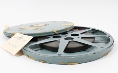
Film, Junior Legacy, 1959
A film of the 1959 rehearsal for Junior Legatee Demonstration at Melbourne Olympic Swimming Stadium. The commentary notes how the fitness programmes avoided bad posture which would 'lead to a loss of confidence in a sensitive child' and helped them to avoid 'falling into bad company and delinquency.' It also noted the 'wise counsel' given to their mothers by Legatees and details the assistance available from Legacy to 9,000 fatherless families in Victoria alone. There are synchronised exercises, judo demonstrations, mass marching, girls creative dancing and a final tableau in readiness for two night's public performances. It is in black and white and last 14 mins, 16mm B/W, Sound. This film has been digitised to preserve its content. Melbourne Legacy gratefully acknowledges the support of the Victorian Government and Public Record Office Victoria for making this possible.A visual record of the numbers of children cared for by Melbourne Legacy and the activities organised for them.Large circular case with semi fitted reel inside. Film is approx. 550 feet, 16mm. Note loose inside case. Two stickers on the lid. Tape scattered around the edge of the lid.Front stickers: CINE SERVICE PTY. LTD. / 368 Post Office Place Melbourne / TITLE DEMO (1959) COPY / No 1 / LENGTH 1000' REEL 1ofl. / It is stressed that the film should be used in a Class project using a 1,000 Watt lamp with a trained Operator handling the machine. Handwritten note: Demo Rehearsal. Film Damaged Other side printed: MELBOURNE LEGACY "Lest We Forget"annual demonstration, junior legatee -
 Orbost & District Historical Society
book, Australian Glass Manufacturers, before 1894
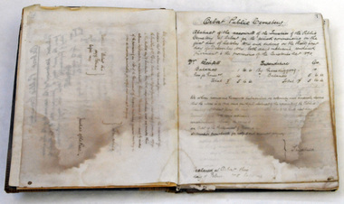
This book was used by Orbost Cemetery Trust to record letters written especially to provide a running account of the trust's activities. Although the cemetery was officially gazetted in November, 1891, it seemed certain that burials had taken place before that time. The early trusts were diligent in their record keeping and visionary in their planning.The original Trust members approved by the Public Health Department included C. N. Henderson, E. Watt (Ernest), D. Munro (Donald), M. R. Coote (Massy) and James Cameron (recorded at the first meeting of the Trust dated 29th May 1891. The first mention of a Mr. C. Richardson wasn’t until 25th February 1916 whilst the cemetery was under the control of the Orbost Shire Council with select councillors on the committee. Orbost Cemetery is an important part of Orbost's history. Its records are essential in research of local history.A grey covered letter book used by the Orbost Cemetery Trust to record letters written between 1894 and 1907.On spine-Letter Bookorbost-cemetery letter-book -
 Melbourne Water
Photographic View Book, The Melbourne & Metropolitan Board of Works - Water Supply, Sewerage etc. ...Photographic Views, 1908
In 1891 The Melbourne and Metropolitan Board of Works (MMBW) was formed and became responsible for Melbourne's water supply. Melbourne had grown to a city of half a million people. To provide water to this rapidly growing city (especially the eastern suburbs), and to supplement the 1857 Yan Yean Reservoir, Melbourne's first water supply, the Watts River (near Healesville) was tapped. It supplied water to Melbourne, via the Maroondah aqueduct. In May 1892 the MMBW's first engineer-in-chief, Mr William Thwaites began construction on Melbourne's sewerage system. A treatment farm was built at Werribee and a pumping station was built at Spotswood (now the site of the Scienceworks Museum) to send the city's waste to Werribee. The first Melbourne homes were connected to the sewerage system in 1897. This book showcases the MMBW's infrastructure achievements and documents costs, requirements and key personnel involved in the development of the water supply and sewerage schemes.The introduction states "The water supply sources and headworks are in many cases situated in remote places and the sewerage works are chiefly underground. The Board has therefore resolved that these photographs of some of the scenes and works should be collected and bound for general information. August 1908" This book is in excellent condition and provides a detailed insight into the previous 17 years of work and the Board personnel of the MMBW leading up to 1908. It is of historical importance to the history of Melbourne for the photographic documents of places that were not generally open to the public, and for Melbourne Water in its detailed history of the MMBW in the early twentieth century. Photographic view book with hard khaki coloured cardboard cover and blue fabric binding. 120 Pages. Glossy paper with black and white plates and text about the MMBW, and scenic views and places of interest in association with the MMBW. The Melbourne & Metropolitan Board of Works - Water Supply, Sewerage etc. ...Photographic Views...mmbw, board members, sewerage, water supply, historic views, photographs -
 Vision Australia
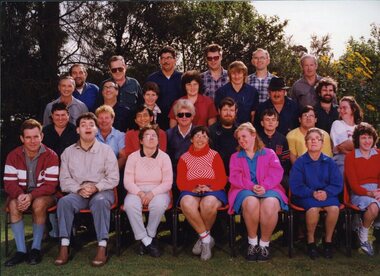
Photograph - Image, QBIC workers on the Annerley Campus of Yeronga TAFE
A group of QBIC workers and administrative staff. This image was used in the book "Vision Queensland, QBIC and Queensland Industrial Institution: a history 1883-1998" by Basil Shaw. Left to Right: Back row: Lionel Hubon, John Reed, Alan Nemeth, Lindsay Arndt, Kevin Watts, Tom Chawner. Third row: Sam McCord, Colin Ingram, Diane King, Jenny Scown, Andrew Brown, Lloyd Miles, Michael Thorn. Second row: Kenny Rogers, Yvonne Lord, Joe Seeto, Duncan Collard, Richard Howell, Greg Bond, Mark Pelgrave, May Brown. Front row: Tom Rowe, Michael Bor, Vicki Waugh, Anne Van Bekkum, Cathie Dendrik, Barbara Harding, Anne Maree O'Connell.1 x col. photograph of peopleProperty of Sam McCord - please return 20 Enlarge to 2 col wideemployment, qbic industries, lionel hubon, john reed, alan nemeth, lindsay arndt, kevin watts, tom chawner, sam mccord, colin ingram, diane king, jenny scown, andrew brown, lloyd miles, michael thorn, kenny rogers, yvonne lord, joe seeto, duncan collard, richard howell, greg bond, mark pelgrave, may brown, tom rowe, michael bor, vicki waugh, anne van bekkum, cathie dendrik, barbara harding, anne-marie o'connell -
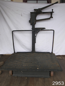 Flagstaff Hill Maritime Museum and Village
Equipment - Platform Scales
Large platform scales such as these ones made by W. & T. Avery were used for weighing goods for trading and passengers' luggage. They would be used in places such as railway stations, shipping ports, customs offices and ticketing offices. Often fees would be charged to customers according to the weight of their goods and luggage. Items would be placed onto the large horizontal platform then weights would be added to the weighing bar until the bar leveled to being horizontal. The weights would be added together and the total of the weights would be used for the final figure. These scales were made in Birmingham, England, by the British company, W and T Avery. The company had its origins in the early 1700s but only became known as W and T Avery when the brothers William and Thomas Avery inherited the scale-making business from a relative, Joseph Balden, on his death in 1813. By 1885 they had three factories and In 1895, the company acquired James Watt & Co and two years later had moved to the 25-acre Soho Foundry site in Smethwick, Birmingham where James Watt had manufactured steam engines. When the last Avery family member died in 1918, the company employed over 3,000 people and had businesses all over the world. Following the highly successful introduction of the first digital retail scale in 1971, the company was taken over by the GEC Group in 1979. The business was subsequently acquired by the American company, Weigh-Tronix, in 2000 which had already acquired a competitor, Salter. The Avery name continues today in the company known as Avery Weigh-Tronix.An item that was used at the turn of the century as train platform scales or for weighing agricultural products. Made by a company that pioneered weighing equipment with offices all over the world. With many examples of this scale in museums throughout the world. Platform scales with wheels. Large cast iron, scales painted black, weight capacity to 7 CWT (hundred weight). Weight beam has markers "0. 5. 10. 15. 20. 25". Platform scale loose weight type with relieving handle; cast iron construction, fluted columns with integral weight stand, the two wheels are fitted to base at front of platform; there is a graduated steelyard 0-14bs with pear-shaped poise. Weight carrier is missing.Pressed into cast iron arm on scale, one side "W. & T. AVERY", opposite side "BIRMINGHAM", and into the platform "TO WEIGH 7 CWT, W. & T. AVERY, MAKERS, LONDON & BIRMINGHAM" flagstaff hill, warrnambool, shipwrecked-coast, flagstaff-hill, flagstaff-hill-maritime-museum, maritime-museum, shipwreck-coast, flagstaff-hill-maritime-village, measuring scales, weighing scales, weighing instrument, fees for goods, fees for luggage, ticket office -
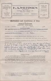 Bendigo Historical Society Inc.
Document - H. A. & S. R. WILKINSON COLLECTION: CONTRACT OF SALE
Conditions of sale by private contract dated 12th March, 1948 between C. J. Watt (vendor) and W. & M. L. Seckold (purchaser). Property: all that piece of land situate No. 28 Vine Street, Bendigo, at present occupied by D. Ellis as tenant, being part of Crown allotment 9 section 129C, Parish of Sandhurst City of Bendigo, being the land described in certificate of title volume 4685 folio 936900, together with 6 room weatherboard dwelling and all sundry outbuildings except any such outbuildings belonging to the tenant. Subject to existing tenancy. Price: 810 pounds. Attached 2 hand written notes plus a certificate of valuation giving a breakdown of the valuation.organization, business, h.a. & s.r wilkinson real estate -
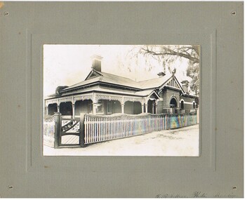 Bendigo Historical Society Inc.
Photograph - T C WATTS & SON COLLECTION: CNR HARGREAVES & CHAPEL STREETS, 1927
BHS CollectionBlack and white photograph mounted on rectangular grey board. House, C.G.I. roof, finials to decorated gable ends, 3 brick chimneys w/decorated white capitals. Verandah has gable over front entrance, bowed corner window under verandah posts w/case iron lace above. Roughcast archway surrounds window under R.H. gable, two arched windows. R.H. rear of house. Wooden Fence pickets w/figured tops, capitals to gate posts, decorative front gate, hedge is clipped in harmony with fence tops. Cnr Hargreaves & Chapel Streets. Written on envelope: TC. Watts & Son, Cr Hargreaves and Chapel St. £1600.F.A. Jeffree, Photo, Bendigoplace, building, residential, chapel street, hargreaves street -
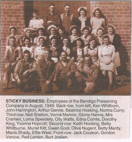 Bendigo Historical Society Inc.
Newspaper - JENNY FOLEY COLLECTION: STICKY BUSINESS
Bendigo Advertiser "The way we were" from Friday, May 14, 2004. Sticky business: employees of the Bendigo Preserving Company in August 1949. Back row from left: Ken Whitburn, John Harrington, Arthur Genne, Beatrice Hosking, Norma Curry. Third row: Nell Shelton, Verna Mannix, Gloria Hanna, Mrs Crameri, Lorna Speedley, Olly Watts, Edna Comte, Dorothy King, Yvonne Hopcott. Second row: Keith Hocking, Betty Whitburne, Muriel Kitt, Gwen Gool, Olive Nugent, Bedtty Mardy,, Mavis Shady, Effie West. Front row: Jack Coulston, Gordon Vercoe, Red Lenten, Burt Joslien.newspaper, bendigo advertiser, the way we were -
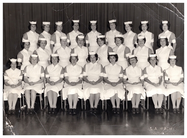 Northern District School of Nursing. Managed by Bendigo Historical Society Inc.
Photograph - Training Schools 54, 1962
The Northern District School of Nursing opened in 1950 to address the issues around nurse recruitment, training and education that had previously been hospital based. The residential school was to provide theoretical and in-house education and practical training over three years. The students would also receive practical hands-on training in the wards of associated hospitals. The Northern District School of Nursing operated from Lister House, Rowan Street, Bendigo. It was the first independent school of nursing in Victoria and continued until it closed in 1989.P.T.S. Training school 54 25/4/1962 Black and white photograph; of a group of 26 female nurses in three rows, the first row sitting and the second and third standing. Back Row: Bev Hay, Doreen Brie, Jill Holland, Peggy Lyons, Pauline Schultz, Lenny Watts, Eileen Coleman, June Phemister, Denise Reade. Middle Row: Maureen Deveraux, Jenny Thompson, Eileen McGauchie, Diane Cutts, Liz Hefford, Elaine Erhardt, Rona Toohey, Kath Thorbridge. Front Row: Elaine Cameron, Dot Foyster, Jan Aitken, Lois Letcher, Dorothy Atkinson, Faye Horneman, Heather McBeth, Elva Fenton, Noeleen Christopher. nurse training, ndsn, lister house, school 54