Showing 177835 items matching "ely-street"
-
 Linton and District Historical Society Inc
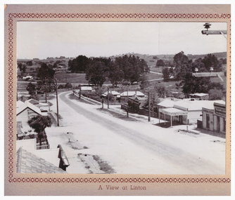
Postcard, A View at Linton, Sussex Street, Linton, view to south, circa 1940
The "Lorna, Bob and Elsie" in the inscription are probably Elsie McCorkell, her son Robert Hayward, and her daughter Lorna McCorkell.A very small photograph which has been made into a souvenir/postcard. The photograph is a view of Sussex Street, Linton, looking south-west. On the right of the photo are Ching's store, R. N. Sandow confectionery shop, a house next to it, and the first Bank of NSW building. Two houses are further down the road past Gillespie Street. On the left of the photo are the Edinburgh Bakery and a store with a verandah on the corner of Gillespie Street. The photograph is glued to a beige-coloured card which has a decorative edge cut into it. A printed border surrounds the photograph, and the words "A View at Linton" are printed underneath it. The card appears to have had the right-hand edge trimmed with scissors. Because of this, an inscription on the back of the card has been partially cut away. The inscription reads "-rs Whitehand & Doris / -with love from Lorna, Bob and Elsie".sussex street linton, buildings, shops, houses, sandow shop, ching's store, edinburgh bakery, postcards, souvenirs, lorna mccorkell, robert hayward, elsie mccorkell -
 Warrnambool and District Historical Society Inc.
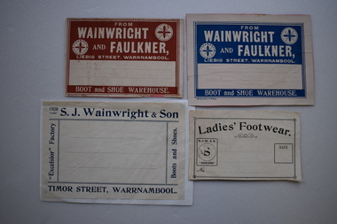
Labels, Wainwright and Faulkner, C1900
Mr Sidney (Sydney) Wainwright's father was established in the boot and shoe manufacturing business from 1877 in partnership with Shaddock and then Faulkner in Liebig Street, Warrnambool. By the late 1800s S.J. Wainwright and Son had 50 employees in the Timor Street factory which was one of the most extensive boot making businesses in the Western District.These labels are of some significance as Wainwright and Faulkner operated a important boot making business at the beginning of the 20th century in Timor Street, Warrnambool..1 White and blue rectangular label with text and decorations attached to a pink card. .2 Identical to .1 excepting the label is buff and the text is brown. .3 Buff rectangular label with black text and decorative border attached to a buff card. .4 Buff rectangular label with dark blue text and lines attached to white paper. .1 FROM WAINWRIGHT AND FAULKNER, LIEBIG STREET, WARRNAMBOOL. BOOT AND SHOE WAREHOUSE MODERN PRINT WARRNAMBOOL .2 Identical to .1 .3 Ladies' Footwear. S.J.W &S. "EXCELSIOR" SIZE .4 FROM S. J. WAINWRIGHT & SON " EXCELSIOR" FACTORY. TIMOR STREET, WARRNAMBOOL . Boots and Shoes.wainwright, faulkner, boot and shoe manufacture -
 Eltham District Historical Society Inc
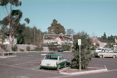
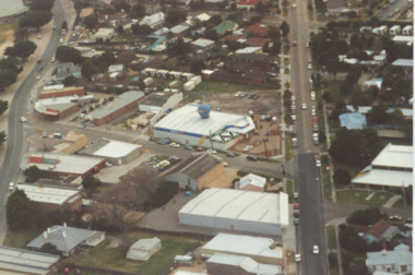
Slide, Pryor Street carpark, Eltham, 25 Jul 1973
View through the Pryor Street carpark which ran between Luck and Pryor streets. The original Safeway supermarket is visible in the background off Pryor Street. Cars in the immediate vicinity are a Morris 100, and HD/HR Holden wagon and an HQ Holden35 mm colour positive transparency Mount - Agfacolor Service (Blue)eltham, pryor street, carparks, hd holden, hq holden, morris 1100, safeway supermarket, shopping centre, streets, hr holden, luck street -
 Eltham District Historical Society Inc
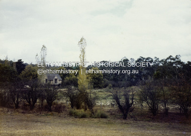
Colour Print, David Taylor, Matcham Skipper's house on stilts alongside the Dalton Street Lane, Eltham, c.1976
Looking south from the rear of 62 Brougham Street (Peter Garner's studio). Matcham Skipper's house was built adjacent to the laneway, an extension of Dalton Street, running from Main Road to Bell Street, now known as Wingrove Park Traildavid taylor collection, eltham, matcham skipper, peter garner adobe studio -
 Ringwood and District Historical Society
Map, Proposed Subdivision - Hilltop Estate, Heathmont, Victoria - circa 1925
Plan of Part of Crown Allotments 16 & 18, Parish of Ringwood, County of Mornington. Subdivision includes Site for Heathmont Station, Heathmont Road, George Street, Lilian Street, Edith Street, Edna Street, Great Ryrie Street. Inset locality plan also shows nearby Electric Railway Estate and Heathmont Station Estate. L.H. Webber, Licensed Surveyor, 440 Little Collins Street, Melbourne. -
 Tatura Irrigation & Wartime Camps Museum
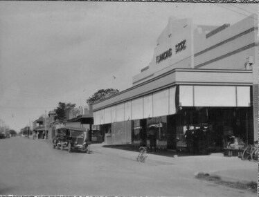
Photos, Hogan Street Tatura
Early Tatura photos emailed.|Hogan Street looking east from railway line, c.1910.|Flanagans Store c.1935, showing shop on corner and possibly the first fire station on N.E. corner of Ross & Hogan Streets.|Hogan Street looking west from railway line c.1910(2).|Flanagans' Store on cnr. Ross and Hogan Streets, c.1910.tatura, hogan street, flanagans store, local, history -
 Flagstaff Hill Maritime Museum and Village
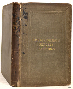
Book - Financial Reports, Bank of Australasia, Bank of Australasia Reports 1835-1857, 1857
This book contains the Reports of the Bank of Australasia from 1835-1857 and was published in the Bank's head office in London in the year of the last report within the book. The Reports date from the incorporation of the Bank. The Bank of Australasia was incorporated by the Royal Charter of England in March 1834. The bank began in Australia on 14th December 1835, opening in Sydney. The Acting Superintendent of the bank at that time was David Charters McArthur. He was Superintendent from 1867-to 1876. The Melbourne branch opened on 28th August 1838 in a two-roomed brick cottage on the north side of Little Collins Street, where two huge mastiff dogs were used at night to guard the bank. The government also provided an armed military sentinel. Due to the bank's rapid growth, a new building for the Melbourne branch was opened in 1840 at 75 Collins Street West. By 1879 the bank had been upgraded to a magnificent two-storey building on the corners of Collins and Queens Streets, with the entry on Collins Street. In 1951 the Bank of Australasia amalgamated with the Union Bank to form the Australia and New Zealand Bank, now known as the ANZ. Then in 1970, the ANZ merged with both the ES&A and the London Bank of Australia to form the ANZ Banking Group Limited. The ANZ Banking Group Ltd kindly donated a variety of historic items from the Bank of Australasia. BANK of AUSTRALASIA, WARRNAMBOOL – In 1854 Warrnambool had two banks, the Union Bank and the Bank of Australasia. Later, completely different bank businesses opened; in 1867 the National Bank of Australasia, then in 1875 the Colonial Bank of Australasia. The original Warrnambool branch of the Bank of Australasia was established in July 1854, and operated from a leased cottage on Merri Street, close to Liebig Street. The bank later bought a stone building previously erected by drapers Cramond & Dickson on the corner of Timor and Gibson Streets. Samuel Hannaford was a teller and then Manager at the Warrnambool branch from 1855 to 1856 and the Warrnambool Council chose that bank for its dealings during 1856-57. In 1859 Roberts & Co. was awarded the contract to build the new Bank of Australasia branch for the sum of £3,000. The land was on a sand hill on the northeast corner of Timor and Kepler Streets and had been bought in 1855 from investor James Cust. The new building opened on May 21, 1860. The bank continued to operate there until 1951 when it merged with the Union Bank to form the ANZ Bank, which continued operating from its Liebig Street building. Warrnambool City Council purchased the former Bank of Australasia building in 1971 and renovated it, then on 3rd December 1973 it was officially opened as the Art Gallery by Cr. Harold Stephenson and Gallery Director John Welsh. The Gallery transferred to the purpose-built building in Liebig Street in 1986 and the old bank building is now the Gallery club. Staff at the Bank of Australasia in Warrnambool included the following men but others were also involved: Samuel Hannaford, Teller then Manager from 1855-1856; W H Palmer, Manager from January 1857 until November 1869 when the Teller Basil Spence was promoted to Manager; H B Chomley, Manager from April 1873 and still there in 1886; A Butt, Manager in 1895-1904; J R McCleary Accountant and Acting Manager for 12 months, until 1900; A Kirk, Manager 1904; J Moore, staff until his transfer to Bendigo in December 1908; J S Bath was Manager until 1915; C C Cox, Manager until April 1923; Richard C Stanley, Manager 1923 to April 1928. The book has historical significance as it is connected to the Bank of Australasia which was established in Australia in 1835 by Royal Charter during the early Colonial period of Australia's history. The reports within the book begin from the time the bank was established and include the time that the Warrnambool branch was in operation. The book is significant for its association with the Bank of Australasia in Warrnambool, the first bank in Warrnambool, established in 1854. The bank continued to operate until its merger in 1951 when it became the ANZ Bank, which is still in operation today. The Bank was an integral part of the establishment and growth of commerce in Colonial Warrnambool and throughout Australia.Book, brown fabric covered board covers with embossed borders front and back. The titles on the front and spine are embossed and gilt. The fly page includes the insignia of the Bank of Australasia. The book contains reports of the Bank of Australasia from 1835-1857. It was published by the Bank at its London address in 1857. Inscription in pencil. Date: 1857 Published by the Bank of Australasia."BANK OF AUSTRALASIA / REPORTS / 1835-1857" "NO. 4, THREADNEEDLE STREET, LONDON. / 1857." Pencil, handwritten "L32"flagstaff hill, warrnambool, shipwrecked coast, flagstaff hill maritime museum, maritime museum, shipwreck coast, flagstaff hill maritime village, great ocean road, commerce, banking, bank of australasia, anz bank, david charters mcarthur, d c mcarthur, australia, bank reports, 1835-1857, financial reports, financial record -
 Kew Historical Society Inc
Photograph, City of Kew, 'Otira', Walpole Street, Kew, c.1980
One of a series of photos created for an exhibition by the City of Kew of notable locations. The photos represent a snapshot in time.Enlarged photograph of Otira, Walpole Street, Kew, mounted on board, and donated to the Kew Historical Society by the City of Kew on 10 April 1991. The house is still extant (August 2017). This is a photo of the house before the front veranda was reinstated.From Kew City C'cil 10 April 1991otira - walpole street - kew, historic houses -- kew (vic.) -
 Surrey Hills Historical Society Collection
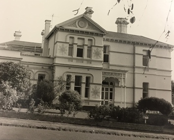
Photograph, Rear of Varndean from Willcyrus Street, 1988, 1988
Ref: Alan Holt records - This property has had a number of different names throughout its history. William Cook, a farmer, bought the land it stands on in 1876. In 1882 he was rated for a house (not the current one) on 11 acres. The present house was built in 1885 by John Clark, an auctioneer. In 1888 the Tower Hill estate and the home (Tower Hill Lodge) were auctioned, but the house was not sold. In 1889 the house was purchased by Captain Shepherd. Records show that in 1894 the owners were Mr Thomas and Mrs Hortenzia Howell. They named the house 'Corcovado'. Later they added a study with a corner designed to provide views from the Dandenong Ranges around to Mt Macedon. In 1944 Mr and Mrs Lionel Adams renamed the house 'Varndean'.This is one of the earliest surviving houses in Surrey Hills.A colour photo taken from the street at the rear of a Victorian-style house with ornate chimneys and a slate roof. A parked car is seen in front of the house. The house sits behind a timber fence and is partly hidden by mature shrubs and trees.victorian style, tower hill lodge, corcovado, varndean, tower hill estate, mr william cook, mr john clark, mrs hortenzia howell, mr lionel adams, mrs lionel adams, surrey hills, captain louis shepherd, mr thomas howell -
 Lakes Entrance Historical Society
Photograph - Dahlsens Mitre 10, Church Street, Lakes Entrance Victoria, 1/07/1994 12:00:00 AM
Colour photograph of businesses and residences adjacent to the newly opened Dahlsens Mitre 10 store Church Street Lakes Entrance Victoria. Also a second aerial photograph showing closer view of Mitre 10 store slightly blurred businesses, roads and streets, township planning -
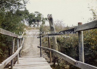 Eltham District Historical Society Inc
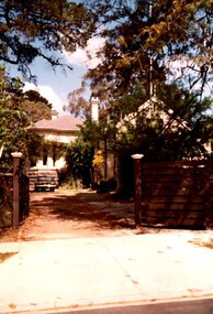
Colour Print, David Taylor, Footbridge over the Diamond Creek, Dalton Street Lane, Eltham. View heading west towards Bell Street, c.1976
The laneway past Skipper's house, an extension of Dalton Street on the western side of Main Road, has long been a regular route for Eltham High School students heading to and from school. Its present day name is Wingrove Park Trail. The footbridge over the creek was regularly subjected to damage or washed away during floods. A more substantive and flood resistant footbridge has since been erected. david taylor collection, eltham, wingrove park trail, dalton street lane, dalton street footbridge -
 Eltham District Historical Society Inc
Slide - Photograph, Sackville Street, Montmorency, c.Mar. 1985
Sackville Street, Montmorency (part of the Quinn Estate) looking towrds Bolton Street from outside No. 102, c. Mar. 198535mm colour positive transparency (1 of 15) Mount - Kodak Kodachrome Cardinfrastructure, roads, montmorency, quinn estate, sackville street -
 Eltham District Historical Society Inc
Slide, Main Road at Bolton Street, Eltham, 25 Jul 1973
Looking east along Main Road towards Bolton Street. Bolton street shops visible. Prior to duplication of Main Road35 mm colour positive transparency Mount - Agfacolor Service (Blue)bolton steet, bolton steet shops, eltham, main road -
 Greensborough Historical Society
Photograph - Digital Image, Main Street upgrade 1960s, 1978c
Photograph of upgrade works in lower Main Street area, taken in the late 1960s. Shows construction of rail bridge and Main Street.Digital copy of colour photographmain street greensborough -
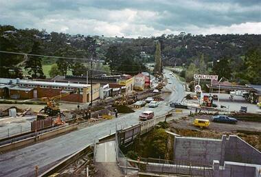
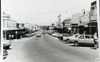 Stawell Historical Society Inc
Photograph, Main Street Stawell before the Mall
Stawell Main street before Mall looking West. Earles Supermarket on left Commonwealth Bark on right. Cars parked in Street.stawell streetscape -
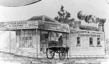 Stawell Historical Society Inc
Drawing, Mr G. Mahnke, London Bakery on the corner of Main Street and Wimmera Streets Stawell c1890 -- Sketch
G. Mahnke London Bakery G. Mahnke corner of Main Street and Wimmera Street From Sketch series Circa 1890stawell businesses -
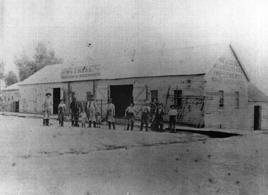 Stawell Historical Society Inc
Photograph, W & J Heal Blacksmiths & Wheelwrights in Upper Main Street with workmen at the front. Three photographs at same time
Group of workmen in front of W & J Heals Blacksmiths and Wheelwrights Upper Main Street located at extreme top of Main Street.Three similar photographs of Blacksmiths and Wheelwrights Coachbuilder and Painter building. stawell business -
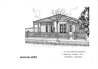 Hawthorn Historical Society
Drawing - Property Illustration, 14 & 14A Hastings Road, Hawthorn East
'After training as a Cartographic Draftsman within the mining industry, I worked as a property illustrator for real estate firms in the eastern suburbs of Melbourne for 23 years from 1983. I initially photographed houses with a Polaroid camera and made a 'thumbnail' sketch while there. The photos were used to scale off a sketch in pencil and then that sketch was overlaid with drafting film and the 'pen and ink' completed. The pens I used were the Rotring ‘Rapidigraph’ drafting pens. The ink was also made by Rotring (German).The film was ‘Rapidraw’, polyester drafting film, double matte. It takes a very fine line and doesn’t bleed. As well as house sketches, there were often floor plans and site plans ordered. Aerial sketches were ordered when the property needed an overall view.' (Margaret Picken, 2020)This property illustration is one of a series created by Margaret Picken for a range of real estate agents in Melbourne between c. 1983 and c. 2006. Each work is signed and dated by the artist.Gift of Margaret Picken, 2020pen and ink architectural drawing on drafting film. Dimension 248x183 Inscription: 14 & 14A HASTINGS RD, HAW E Margaret Picken ~94 WOODARDS -HAWTHORN14 & 14A HASTINGS RD, HAW E Margaret Picken ~94 WOODARDS -HAWTHORNartist - margaret picken 1950- -
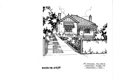 Hawthorn Historical Society
Drawing - Property Illustration, 45 Havelock Road, Hawthorn East
'After training as a Cartographic Draftsman within the mining industry, I worked as a property illustrator for real estate firms in the eastern suburbs of Melbourne for 23 years from 1983. I initially photographed houses with a Polaroid camera and made a 'thumbnail' sketch while there. The photos were used to scale off a sketch in pencil and then that sketch was overlaid with drafting film and the 'pen and ink' completed. The pens I used were the Rotring ‘Rapidigraph’ drafting pens. The ink was also made by Rotring (German).The film was ‘Rapidraw’, polyester drafting film, double matte. It takes a very fine line and doesn’t bleed. As well as house sketches, there were often floor plans and site plans ordered. Aerial sketches were ordered when the property needed an overall view.' (Margaret Picken, 2020)This property illustration is one of a series created by Margaret Picken for a range of real estate agents in Melbourne between c. 1983 and c. 2006. Each work is signed and dated by the artist.Gift of Margaret Picken, 2020pen and ink architectural drawing on drafting film. Dimension 204x186 Inscription: 45 HAVELOCK RD, HAW E Margaret Picken ©2000 WOODARDS -HAWTHORN45 HAVELOCK RD, HAW E Margaret Picken ©2000 WOODARDS -HAWTHORNartist - margaret picken 1950- -
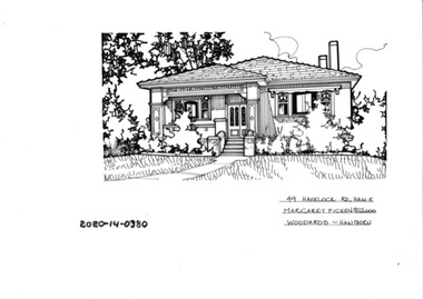 Hawthorn Historical Society
Drawing - Property Illustration, 49 Havelock Road, Hawthorn East
'After training as a Cartographic Draftsman within the mining industry, I worked as a property illustrator for real estate firms in the eastern suburbs of Melbourne for 23 years from 1983. I initially photographed houses with a Polaroid camera and made a 'thumbnail' sketch while there. The photos were used to scale off a sketch in pencil and then that sketch was overlaid with drafting film and the 'pen and ink' completed. The pens I used were the Rotring ‘Rapidigraph’ drafting pens. The ink was also made by Rotring (German).The film was ‘Rapidraw’, polyester drafting film, double matte. It takes a very fine line and doesn’t bleed. As well as house sketches, there were often floor plans and site plans ordered. Aerial sketches were ordered when the property needed an overall view.' (Margaret Picken, 2020)This property illustration is one of a series created by Margaret Picken for a range of real estate agents in Melbourne between c. 1983 and c. 2006. Each work is signed and dated by the artist.Gift of Margaret Picken, 2020pen and ink architectural drawing on drafting film. Dimension 255x165 Inscription: 49 HAVELOCK ROAD, HAW E Margaret Picken ©2000 WOODARDS -C'WELL49 HAVELOCK ROAD, HAW E Margaret Picken ©2000 WOODARDS -C'WELLartist - margaret picken 1950- -
 Whitehorse Historical Society Inc.
Document, Prime commercial auction, 1985
Auction brochure - 495-499A Whitehorse Road and 5 Enterprise Way Mitcham 27 November 1985.Auction brochure - 495-499A Whitehorse Road and 5 Enterprise Way Mitcham 27 November 1985. Agent: C E Carter & Son Pty Ltd.Photo includes Ivory Restaurant.Auction brochure - 495-499A Whitehorse Road and 5 Enterprise Way Mitcham 27 November 1985. enterprise way mitcham, no. 5, whitehorse road mitcham, nos. 495-499a, ivory restaurant, mitcham, c e carter and son -
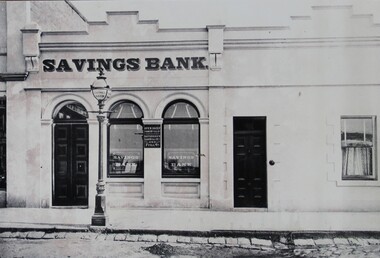 Stawell Historical Society Inc
Photograph, Savings Bank in Upper Main Street Stawell -- opened 1880
Sepia Photo of Savings Bank Upper Main Street Stawell. First opened in 1880. Note the decorative Gas Fired street lamp. stawell -
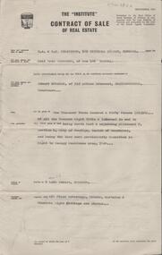 Bendigo Historical Society Inc.
Document - H. A. & S. R. WILKINSON COLLECTION: CONTRACT OF SALE
Contract of sale of real estate dated 7th December, 1964 between Mr. N. E. Schroder (vendor) and Mr. E. Strahan (purchaser). Solicitor for vendor: Messrs. E. S. Cahill & Son, View Street, Bendigo. Solicitor for purchaser: Messrs. E. S. Cahill & Son, View Street< Bendigo. Property 9 Lobb Street, Bendigo being North East and adjoining allotment 7, section K land described in right to occupy residence area 7824 together with all floor coverings, blinds, curtains and electric light fittings and shades. Price 1,350 pounds.organization, business, h.a. & s.r wilkinson real estate -
 Stawell Historical Society Inc
Photograph, Canadian Redwood tree in the Old Kays Foundry site in Sloane Street Stawell
Large Tree – in Old Kays Foundry site Sloane Street Tree. Canadian Redwood. 17 Sloan Street and corner of Allen Street. House called "Bedale" demolished in 1996 was built in 1903 probably the home of George Kay of Wayman and Kay Foundry. Two photosstawell -
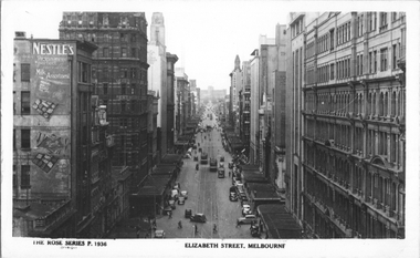 Melbourne Tram Museum
Postcard, Rose Stereograph Co, "Elizabeth Street, Melbourne", early 1940s
Rose Series postcard No. P 1936 titled "Elizabeth Street, Melbourne". Photo taken from the tower at Flinders Street Railway station, looking north along Elizabeth Street. Has several W5 class trams in the view with white panels under the driver's windows. Yields information about an aerial view of Melbourne early 1940sPostcard - printed real photograph with Rose Stereograph Co. name on the rear.tramways, trams, elizabeth st, world war ii, w5 class -
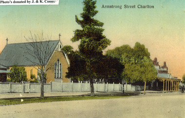 Charlton Golden Grains Museum Inc
Photograph, St Martin's Anglican Church, Armstrong St Charlton
St Martin's Anglican Church was built in 1889. Victoria Hall was built for E. Miles in 1884. The post card is part of a series taken c. 1907.Copy of a coloured (hand coloured?) post card showing St Martin's Anglican Church, Armstrong St, Charlton. The church is a yellow, timber building with a cross at each end of the roof. A white picket fence runs along the front of the church. There are three trees on the edge of the road in front of the church. There is a large single storey red brick building to the right of the church with a verandah over the footpath. A horse is coming down the road past the red brick building. The post card has Armstrong Street Charlton in the top right. There is a typed note in the top LH corner of the photo that says Photo's donated by J. & K. Cossar.pastoral care, st martin's, angllican, church, armstrong street, charlton -
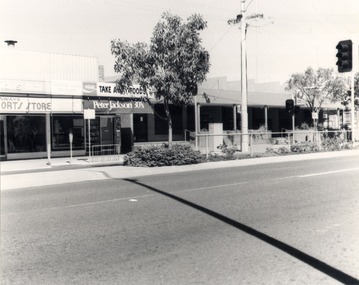 Wodonga & District Historical Society Inc
Photograph - Codling Collection 01 - Eastern side of High Street, Wodonga, 1980s
Miss Olive Codling was a Foundation Member and a Life Member of the Wodonga Historical Society. Many of her prize-winning photos are held in the Society Collection. She also held a range of roles and committee positions in a wide range of Wodonga community organisations. These included the Horticultural Society, the Wodonga Arts Council, the Wodonga Camera Club and the Wodonga Lapidary Club. This photo collection is significant as it documents how the businesses and buildings in Wodonga have evolved and contributed to community throughout the 20th century.Eastern side of High Street, Wodonga. From left Tony Conway's Sports Store, Coffee Lounge Lunch Bar and Take Away and the Post Office. Tony Conway later extended into the Take Away store. To the right of the Post Office was a laneway and then the Wodonga Shire Offices. Tony Conway opened his store with partner Jake Elkington in late 1961. In 1969 he bought the former RSL Hall and moved the Sports Store from across the road in High Street. It stayed in the family until 2007 under the management of Nic Conway.wodonga businesses, high st wodonga, conway's sports store -
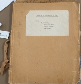 Tatura Irrigation & Wartime Camps Museum
Book, Service of Prisoners of War
"Gerhard Ernst Neumann Briefe Ohne Datum" A book in the possession of G E Neumann and used during his internment in WW2 in Tatura.Dark tan coloured light cardboard cover with fawn coloured pages inside. Tied together with a ribbonfront cover Frau G E Neumann, and an addressgerhard ernst neumann, briefe ohne datum, german internee, ww2 internee -
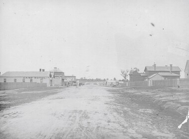 Stawell Historical Society Inc
Photograph, Longfield Street / Western Highway 1866
Part of a collection of Photographs by Mr. O.G. Armstrong as commissioned by the Shire of Stawell for the Inter-colonial and Paris Exhibition in Melbourne in 1866. Longfield Street Stawell (now the Western Highway) looking towards Sister Rocks and Ararat. Pleasant Creek Court House and Shire Hall are on the right, as is a shop on the corner of Seaby Street and Longfield streets. On the left is the Camp Hotel, the Constitution Hotel and the Shamrock Hotel on the far Side of Seaby Street. stawell streetscape -
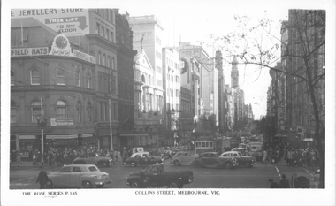 Melbourne Tram Museum
Postcard, Rose Stereograph Co, "Collins Street Melbourne", c1950
Rose Series postcard No. P 185, "Collins Street Melbourne" looking west from the intersection with Swanston Street, c1950. Has two trams eastbound in Collins Street and several motor cars doing a hook turn in the intersection. In the background are Frayefield Hats, Calders and Kodak signs.Yields information about the intersection of Collins and Swanston Streets c1950.Postcard - printed real photograph with Rose Stereograph Co. name on the rear.collins st, tramways, swanston st, trams, mmtb