Showing 10832 items
matching maps
-
 Bendigo Historical Society Inc.
Map - MANDURANG, No date visible
Map: It has the Village of Mandurang on one side and the Township of Laanecoorie on the reversemap, bendigo, parish plan, mandurang, laanecoorie -
Bendigo Historical Society Inc.
Map - NERRING, 25/08/1903 ?
Map: Parish of Nerring, County of Bendigo. Parish plan Canvas backedmap, bendigo, rural, nerring, county of bendigo -
Bendigo Historical Society Inc.
Map - SANDHURST ? SHEET 5, 29/10/1879
Map: Parish plan showing area Northwards from Kangaroo Flatmap, bendigo, parish plan, parish of sandhurst, kangaroo flat -
Bendigo Historical Society Inc.
Map - NEWSTEAD, 28/07/1874
Map: Newstead Town and Suburban Lots, Parish of Strangways. Parish planmap, township, newstead -
Bendigo Historical Society Inc.
Map - LODDON CREEK, Circa 1860
Map: Plan of agricultural lands upon the Loddon Creek in the parish of Shelbournemap, bendigo, agricultural lands, agricultural lands, loddon creek, shelbourne -
Bendigo Historical Society Inc.
Map - SANDHURST (PART), No date visible
Map: Parish plan showing the Southwestern corner of Sandhurst to the Municipal boundarymap, bendigo, parish plan, sandhurst -
Bendigo Historical Society Inc.
Map - SANDHURST (PART), Circa 1880's
Map: Parish plan showing Charleston Rd. Lloyd St. areamap, bendigo, parish plan, sandhurst, charleston road, lloyd street -
Bendigo Historical Society Inc.
Map - TOWN OF INGLEWOOD, March 1946
Map: Town of Inglewood, Parish of Inglewood, County of Gladstone. Parish planmap, gladstone, township, inglewood -
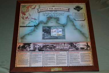 Wangaratta RSL Sub Branch
Framed Poster, Battle for Australia
Battle of Australia poster commemorating the Bombing of Darwin on 19th February, 1942 and includes facts and defence resourcesThe Bombing of Darwin, also known as the Battle of Darwin, was the largest single attack ever mounted by a foreign power on Australia.Brown timber frame of poster featuring map of top end of AustraliaThe Battle for Australia 1942-1945 bombing of darwin, ww2 -
Tatura Irrigation & Wartime Camps Museum
Book, Routledge Taylor and Francis Group, Fabrications, November 2016
Information about Prisoner of War and Internment Camp architecture and geography in the Pacific Carceral ArchipelagoWhite front cover with map. Pink and white spine and back coverThe Journal of the Society of Architectural Historians, Australia and New Zealand. In and Across the Pacificprisoner of war camps, internment camps, pacific carceral archipelago, anoma pieris, society of architectural historians, australia and new zealand -
Tatura Irrigation & Wartime Camps Museum
Brochure, German Military Cemeteries - Normandy
9 photo copied pages of pictures (coloured) with descriptions and maps to explain.ww2 german cemeteries, normandy, german military, john marshall -
Lakes Entrance Regional Historical Society (operating as Lakes Entrance History Centre & Museum)
Book, Gardner, P D, Names Around the Gippsland Lakes, 1991
Origins of the place names around the Gippsland Lakes, Victoria, with illustrations and maps.township, social history, historic sites -
Stawell Historical Society Inc
Map, Underground Survey of the Principal Mines of Stawell 1879, 1879
Pleasant Creek & Newington, Prince Patrick, Prince Alfred, Pioneer and Galatea, Pleasant Creek Cross Reef No. 1&2, Magdala, Old Shaft, Extended Cross Reef, Crown Cross, Great Northern, Sloanes & Scotchmans, South Cross, 10 & 11 United Scotchmans South Cross, Scotchmans Shafts, North Scothmans, West Scotchmans, Emerald Isle & Rose of Denmark, Albion, South Scotchmans, Newington & Pleasant Creek, Pleasant Creek Cross Reef, Moonlight, Extended Cross Reef, Crown cross United, Great Northern ShaftVery large Map on cloth backing, showing cross sections of mines.Surveyed by H.C. Bates. Drawn by Arthur Edwards. October 30th 1879. Scales 120 feet to an inchmining, gold -
Stawell Historical Society Inc
Map, Roads Maintained by NGSC. Roads Maintained by Other Authorities, C 2020
Printed Colour map of Norther Grampians Shire, with roads marked in colourNorther Grampians Shire COuncil. 1:200,000shire, roads, transport -
Stawell Historical Society Inc
Photograph, Stawell Gold Mine, Aerial Photomap of Stawell & Mining 1997, 1997
Evaporation Dams Mining SiteLarge Laminated Aerial Photo Map showing Stawell and Mining activityMining Geology Office 1997mining -
Stawell Historical Society Inc
Map, Department of Lands and Survey, Borough of Stawell. Parishes of Stawell and Illawarra 1903, 1903
Victoria Co., St Georges Co., Wimerra Co., Leviathon Co. Tramway, Quarry reserve, Newington Co., Galatea Co., Moonlight Co., Federal Co., Borough reservior., A0 Map of Stawell on linen backing. Plus one Printed on PaperPhoto Lithograped at the Department of Lands and survey Melbourne by T.F. McGauran 13.6.03surevy -
 Stawell Historical Society Inc
Book, Allan Nelson & Leslie & Carl Loeliger, Lubeck School Centenary 1983, 1983
History of the Lubeck School and "Back to Lubeck" Weekend Sept 11-12 2004. Lubeck School Centenary book compiled August 20th 1983. 687.1 Back To Lubeck Weekend Sept. 11 & 12 2004. 681.2 A Poat Script to Lubeck School Centenary Dec. 17.1989White booklet with map on cover in Green Ink, Title in Brown Printin Brown Print: Lubeck School Cnetenary 1983stawell education -
Stawell Historical Society Inc
Map, Geological Survey Office, Sloanes & Scotchmans united Mine, December 1916
Sloane & Scotchman's Geological Survey Map 1916 Showing Underground DrivesGeological Survey Office Ballarat December 1916 mining, gold, map -
Koorie Heritage Trust
Journal - Serials, Department of Pacific and Southeast Asian History, Australian National University, Aboriginal History - Volume 07. 1-2 1983, 1983
A series of articles by leading writers on Aboriginal History.228 P.; refs. bibs. tables; maps; ports.; 25 cm.A series of articles by leading writers on Aboriginal History.aboriginal australians -- periodicals. | ethnology -- australia -- periodicals. | child welfare - child / parent separation - stolen generations | social welfare - wards of state | social welfare | social welfare - government | government policy - assimilation | family | child welfare | child welfare - adoption and fostering | government policy - commonwealth | government policy - self determination - 1993-2004 | occupations - pastoral industry workers | race relations - violent - massacres, murders, poisonings etc. - to 1900 | politics and government - political action - petitions | cooper, william (1861ð1941) | victoria. aborigines welfare board | victoria. board for the protection of aborigines | victoria. ministry of aboriginal affairs | mclean report | music - vocal - origins | language - kriol - pidgins and creoles - torres strait creole | -
Koorie Heritage Trust
Journal - Serials, Department of Pacific and Southeast Asian History, Australian National University, Aboriginal History - Volume 09. 1-2 1985, 1985
A series of articles by leading writers on Aboriginal History.240 P.; footnotes; appendices; maps; ports.; bibs.; 24 cm.A series of articles by leading writers on Aboriginal History.aboriginal australians -- periodicals. | ethnology -- australia -- periodicals. | animals - birds - brolgas | stories and motifs - emu | indigenous knowledge - botany | indigenous knowledge - zoology | language - change | language - linguistics - language classification | language - linguistics - phonology and phonetics | language - semantics | language - texts and translations - aboriginal to non-aboriginal language | crime - bushrangers and outlaws | law enforcement - police - native police | law enforcement - police trackers | indigenous peoples - pacific | language - kriol - pidgins and creoles - torres strait creole | -
Koorie Heritage Trust
Document - Printed Sheets, Barwick Diane E, Changes in the Aboriginal Population of Victoria, 1863-1966. (extract), 1971
Reviews Aboriginal population and the effects of white settlement on population together with the Aboriginal Protection Board and the Missions influences on population, Government policty and conditions to 1966.288-314 P.; refs.; map; figs.; tables; 30 cm.Reviews Aboriginal population and the effects of white settlement on population together with the Aboriginal Protection Board and the Missions influences on population, Government policty and conditions to 1966. victorian-aborigines - population 1863-1966., board for the protection of aborigines-history., aborigines, victoria-population decline. -
Koorie Heritage Trust
Document - Printed Sheets, Bennett, Catherine et al, Report on Aboriginal Skeletal Remains from Tarwin Meadows, South Gippsland - site number 80201/043, 1986
30 P.; appendices; maps; figs.; tables; plates; 32 cm.skeletal remains-aboriginal-tarwin meadows-south gippsland, anthropology-aboriginal-south gippsland., victorian archaeological survey-aboriginal skeletal remains -
Koorie Heritage Trust
Book, Barlow, Alex et al, You and me living together : the story of Aboriginal land rights, 2001
Aboriginal land rights then and now. Traditional Aboriginal concepts of land and caring for land, and how European settlers ovetook the land, using it for their own purposes and changing it forever. Learn about the land wars that occurred, the years on the reserves and missions and the struggle of Aboriginal people to reclaim their lands. In this book, the story of Aboriginal land rights, then and now, is told. Read about traditional Aboriginal concepts of land and caring for land, and how European settlers overtook the land, using it for their own purposes and changing it forever. Learn about the land wars that occurred, the years on the reserves and missions and the struggle of Aboriginal people to reclaim their lands. -- Back cover.32 p. : ill. (some col.), map, ports. ; 28 cm.Aboriginal land rights then and now. Traditional Aboriginal concepts of land and caring for land, and how European settlers ovetook the land, using it for their own purposes and changing it forever. Learn about the land wars that occurred, the years on the reserves and missions and the struggle of Aboriginal people to reclaim their lands. In this book, the story of Aboriginal land rights, then and now, is told. Read about traditional Aboriginal concepts of land and caring for land, and how European settlers overtook the land, using it for their own purposes and changing it forever. Learn about the land wars that occurred, the years on the reserves and missions and the struggle of Aboriginal people to reclaim their lands. -- Back cover.aboriginal australians -- history -- juvenile literature. | aboriginal australians -- land tenure -- juvenile literature. -
Koorie Heritage Trust
Book, Banfield, Lorna. L, Shire of Ararat Centenary: It's settlement and development 1864-1964, 1964
5-78 p.; ports; tables; maps; bib.; 25 cm.ararat shire-history -
Koorie Heritage Trust
Book, Bonyhady, Tim, Burke & Wills : from Melbourne to myth, 1991
The first half of the book examines the organization and conduct of the expedition by drawing on a wide range of sources either ignored by or unknown to previous writers. The second half considers the changing place of the explorers in Australian culture, examining the presentation of Burke and Wills in paintings and sculptures, poems and plays, films and children's books. Context of Burkes Victorian Exploring Expedition, the course of the expedition and its subsequent place in Australian history and culture; numerous brief references to Aborigines - as guides, the Yantruwanta (Yandruwantha) generosity to Bourke, Wills and King and hostility to expeditions.8-383; ill.; plates; maps; index; ref.; 26 cm.The first half of the book examines the organization and conduct of the expedition by drawing on a wide range of sources either ignored by or unknown to previous writers. The second half considers the changing place of the explorers in Australian culture, examining the presentation of Burke and Wills in paintings and sculptures, poems and plays, films and children's books. Context of Burkes Victorian Exploring Expedition, the course of the expedition and its subsequent place in Australian history and culture; numerous brief references to Aborigines - as guides, the Yantruwanta (Yandruwantha) generosity to Bourke, Wills and King and hostility to expeditions.burke and wills expedition (1860-1861) | burke and wills expedition (1860-1861) in art. | burke and wills expedition (1860-1861) in literature. | australia -- discovery and exploration. -
Koorie Heritage Trust
Document - Printed Sheets, Beauglehole, A . C, The distribution and conservation of native vascular plants in the Victorian Mallee, 1979
ii, 99 p. : ill., map (fold.col.in pocket) ; 21x30 cm.indigenous vascular plants. distribution. victoria. mallee region. | botany -- victoria -- mallee. -
Koorie Heritage Trust
Book, Noble, Gerald W, The Red Gate : A history of Alexandra, 1969
i-ix; 86 p.; maps; index; bib.; 24 cm.squatters -- victoria -- history. | squatter settlements -- victoria -- history. | victoria -- history. | alexandra (vic.) -- history. -
Koorie Heritage Trust
Book, Broome. Richard, Coburg : between two creeks, 1987
ix, 366 p. : ill., ports. ; appendices; maps; ; 26 cm.1. coburg (vic.) -- history. 2. aboriginal inhabitants-coburg., merri creek; woiworung; aborigines-social life and customs -
Koorie Heritage Trust
Book, Buggy, Terry et al, Race relations in colonial Australia : an enquiry approach, 1982
A history text for secondary students. It explores three main areas of conflict in 19th century, Aboriginal relations with white settlers in Sydney area; Poonindie; Coranderrk; uses period documents.vi, 154 pages : illustrations, facsimiles, maps, portraits ; 26 cm.A history text for secondary students. It explores three main areas of conflict in 19th century, Aboriginal relations with white settlers in Sydney area; Poonindie; Coranderrk; uses period documents.australia -- race relations | race relations. australia, 1800-1900. for schools | australia -- race relations. | settlement and contacts - colonisation - 1851- | education - indigenous studies - secondary | race relations - violent - massacres, murders, poisonings etc. - to 1900 | poonindie (west sa si53-11) | southwest new south wales (sw nsw si54, si55) | sydney (nsw si56-05) | healesville / coranderrk (e vic yarra valley sj55-06) | -
Koorie Heritage Trust
Book, Buxton, G. L, The Riverina 1861-1891 : an Australian regional study, 1967
xi, 338 p., [27] of plates : ill., maps ; 23 cm.agriculture -- new south wales -- riverina. | riverina (n.s.w.)