Showing 7219 items
matching rite-way
-
 Melbourne Tram Museum
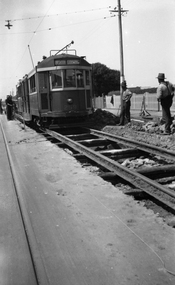
Negative, Wal Jack collection, c1930
Black and white negative from Wal Jack collection of W 259 or W2 during track reconstruction work on its way to North Coburg. The tram has not been fitted with a route number box. A number of workmen in the view "leaning on their shovels" as the tram goes past. Photo could be between Moreland Road and Bell St or in Lygon St before the end of the cable trams in Sydney Road Coburg. OR - in Moreland Road itself, having just left Nicholson St - note heavy wires at the rear of the tram. Photo can be dated from the date a route number box was fitted. Tram was converted to a W2 in Oct. 1931. Photo c1930. Photo may not be by Wal Jack as a size that he did not use.trams, tramways, w2 class, w class, north coburg, sydney road, lygon st, trackwork, tram 259 -
 Tatura Irrigation & Wartime Camps Museum
Book, The Passenger
Book A5 in size, soft cover, black, red and grey cover. Title is slightly diagonally across front cover in white capital letters. Illustration of a man looking back at a train in the background in grey red and black. Red spine with title in white and name of author grey both in capital letters. Back of the book is a dark purple/red colour with small train illustration at bottom in red and grey. There is a white barcode partially covering the illustration of the train. There is a red banner quarter way down the cover, taking up a quarter of the cover with white writing outlining the story line. There are 4 review from News papers two either side of the red banner the review is in red the name of the reviewer and newspaper in white kristallnacht, camp 2, tatura internment camp, "dunera", berlin, ulrich alexander boschwitz, mv abosso -
 Bendigo Historical Society Inc.
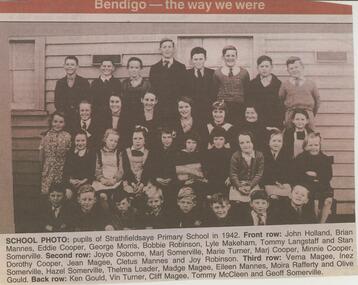
Newspaper - JENNY FOLEY COLLECTION: SCHOOL PHOTO
Strathfieldsaye state School (SS1211) began in March 1873 in the Shire Hall. Five acres were gazetted for a school in January 1874 and a 3 roomed weatherboard school was built and opened in January 1875.Bendigo Advertiser ''the way we were'' from 2002. School photo: pupils of Strathfieldsaye Primary school in 1942. Front row: John Holland, Brian Mannes, Eddie Cooper, George Morris, Bobbie Robinson, Lyle Makeham, Tommy Langstaff and Stan Somerville. Second row: Joyce Osborne, Marj Somerville, Marie Turner, Marj Cooper, Minnie Cooper, Dorothy Cooper, Jean Magee, Cletus Mannes and Joy Robinson. Third row: Verna Magee, Inez Somerville, Hazel Somerville, Thelma Loader, Madge Magee, Eileen Mannes, Moira Rafferty and Olive Gould. Back row: Ken Gould, Vin Turner, Cliff Magee, Tommy McCleen and Geoff Somerville. The clip is in a folder.newspaper, bendigo advertiser, the way we were -
 Eltham District Historical Society Inc
Photograph, Stokes family with horse and sled, Nyora Road, Eltham, c.1950, 1950c
Taken from outside the family home on the southest corner of the intersection of Nyora Road and Pitt Street with Eucalyptus Road, looking northeast across the Stokes Orchard Frank Stokes with children, Dorothy (left), Beryl and David Frank Stokes first traveled to the district by train in 1944 to find land with the intention to establish an orchard. By chance he met Arthur Bird of Bird Orchard (bounded by Pitt Street, Eucalyptus Road and Wattle Grove) and they got talking over their common interest. Arthur put Frank up for the night and pointed out the land, part of Crown Allotment 15, Section 5, Parish of Nillumbik (CA15) somewhat diagonally opposite Bird Orchard. Frank bought the land and for the next two years would travel by train from Melbourne to Eltham every weekend establishing Stokes Orchard and building a home for his family, which they eventually moved into in 1946. In the mid 1970s the Shire of Eltham divided the orchard up into numerous rate-able parcel lots, which became affordable for Frank. As a consequence Stokes Orchard was turned into a housing development by Macquarie Builders and marketed as the Stokes Orchard Estate in two stages; Stage 1 encompassing Scarlet Ash Court, Ironbark Close and Peppermint Grove bounded by Nyora and Eucalyptus roads c.1976 and Stage 2 encompassing Stokes Place, Orchard Way, The Crest and The Lookout bound by Nyora and Diosma roads c.1979. The development of Orchard Way, The Crest and The Lookout did not proceed as planned due to the lack of the sewer along Diosma Road and so many of the proposed lots were incorporated into five-acre parcels instead.Representative of the orchard growing areas of ElthamDigital file only - Digitised by EDHS from a scrapbook (containing commercially printed photos of digital scans) on loan from Beryl Bradbury (nee Stokes), daughter of Frank Stokes.1950, beryl bradbury (nee stokes), beryl bradbury (nee stokes) collection, david stokes, dorothy stokes, eltham, frank stokes, horse, nyora road, sled, stokes orchard -
 Eltham District Historical Society Inc
Photograph, Looking south towards Nyora Road, Eltham, 1977, 1977
Viewed from near the end of Stokes Place where the linear reserve now runs between 8 and 9 Stokes Place just visible through trees in foreground, 24 Nyora with red roof is the first house in middle of view. Frank Stokes first traveled to the district by train in 1944 to find land with the intention to establish an orchard. By chance he met Arthur Bird of Bird Orchard (bounded by Pitt Street, Eucalyptus Road and Wattle Grove) and they got talking over their common interest. Arthur put Frank up for the night and pointed out the land, part of Crown Allotment 15, Section 5, Parish of Nillumbik (CA15) somewhat diagonally opposite Bird Orchard. Frank bought the land and for the next two years would travel by train from Melbourne to Eltham every weekend establishing Stokes Orchard and building a home for his family, which they eventually moved into in 1946. In the mid 1970s the Shire of Eltham divided the orchard up into numerous rate-able parcel lots, which became affordable for Frank. As a consequence Stokes Orchard was turned into a housing development by Macquarie Builders and marketed as the Stokes Orchard Estate in two stages; Stage 1 encompassing Scarlet Ash Court, Ironbark Close and Peppermint Grove bounded by Nyora and Eucalyptus roads c.1976 and Stage 2 encompassing Stokes Place, Orchard Way, The Crest and The Lookout bound by Nyora and Diosma roads c.1979. The development of Orchard Way, The Crest and The Lookout did not proceed as planned due to the lack of the sewer along Diosma Road and so many of the proposed lots were incorporated into five-acre parcels instead.Housing development in Eltham as an extension to the Woodridge EstateDigital file only - Digitised by EDHS from a scrapbook (containing commercially printed photos of digital scans) on loan from Beryl Bradbury (nee Stokes), daughter of Frank Stokes.1977, beryl bradbury (nee stokes) collection, nyora road, stokes orchard estate, stokes place -
 Eltham District Historical Society Inc
Photograph, Stokes Place, Eltham, July 1977, July 1977
Viewed from near the end of Stokes Place where the linear reserve now runs between 8 and 9 Stokes Place looking slightly east of south towards Nyora Road. The new Christian Church on Nyora now the Baptist Church visible in middle view. Frank Stokes first traveled to the district by train in 1944 to find land with the intention to establish an orchard. By chance he met Arthur Bird of Bird Orchard (bounded by Pitt Street, Eucalyptus Road and Wattle Grove) and they got talking over their common interest. Arthur put Frank up for the night and pointed out the land, part of Crown Allotment 15, Section 5, Parish of Nillumbik (CA15) somewhat diagonally opposite Bird Orchard. Frank bought the land and for the next two years would travel by train from Melbourne to Eltham every weekend establishing Stokes Orchard and building a home for his family, which they eventually moved into in 1946. In the mid 1970s the Shire of Eltham divided the orchard up into numerous rate-able parcel lots, which became affordable for Frank. As a consequence Stokes Orchard was turned into a housing development by Macquarie Builders and marketed as the Stokes Orchard Estate in two stages; Stage 1 encompassing Scarlet Ash Court, Ironbark Close and Peppermint Grove bounded by Nyora and Eucalyptus roads c.1976 and Stage 2 encompassing Stokes Place, Orchard Way, The Crest and The Lookout bound by Nyora and Diosma roads c.1979. The development of Orchard Way, The Crest and The Lookout did not proceed as planned due to the lack of the sewer along Diosma Road and so many of the proposed lots were incorporated into five-acre parcels instead.Housing development in Eltham as an extension to the Woodridge EstateDigital file only - Digitised by EDHS from a scrapbook (containing commercially printed photos of digital scans) on loan from Beryl Bradbury (nee Stokes), daughter of Frank Stokes.1977-07, beryl bradbury (nee stokes) collection, eltham, eltham christian church, stokes orchard estate, stokes place -
 Orbost & District Historical Society
May 1900
This is a photograph of the original Orbost / Snowy River Bridge , a suspension bridge which opened in 1893. It has been taken when the Snowy River was in flood. It is similar to other photographs held in The State Library, Victoria. The Snowy River Mail and Tambo and Croajingolong Gazette Sat 12 Aug 1893 records the opening of this bridge as "the most important public event that has yet been commemorated in Eastern ......The Messrs McLeod, with whom the first settlement of this district is generally associated, took up their residence on the eastern bank of the Snowy River about the year 1841 or 42. The late Mr W. Roadknight and Mr T. T. Stirling took possession of the territory on the western side of the Snowy about 35 years ago. During the occupation of the country by cattle owners, very little progress was made in the way of roads and bridges, and except to the hardy and lexperienced bushman, it might have been generally regarded as inaccessible. About the year 1877, however, the late Mr James Robertson eldest son of Mr James Robertson, of Lochend farm, selected land now occupied by his father, about four miles from Orbost on the west bank of the river, Mr John Cameron visited the. district shortly after a .tour of inspection and returned later with his brothers, James and Alick Gameron, but found that during their absence Mr Ernest Watt had found his way on the scene and pegged out a selection, thus anticipating the advent of the Camerons by about 12 hours. We understand that a Mr Kidd, who selected the property now occupied by Mr W. J. Ross, at Pumpkin Point, was one of the earliest batch of settlors.........."This is a pictorial record of an early bridge across the Snowy River at Orbost.A black / white photograph of a suspension bridge with flood waters below the bridge.orbost-bridge suspension-bridge snowy-river -
 8th/13th Victorian Mounted Rifles Regimental Collection
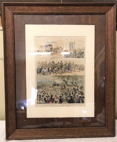
Work on paper - VMR, Labour and Shipping Strike
Probably originally drawn for publication in Melbourne newspaper showing detachment of Victorian Mounted Rifles on way to establish order at a strike site during the Labour and Shipping Strike of August 1890. During the strike armed troops were deployed to support the police in Melbourne and in Newcastle and a number of other ports around the country. In Melbourne, the announcement that a public meeting was going to be held on 31 August 1890 to support the maritime strikers sent the Victorian government into precautionary mode. On the eve of the meeting, the Victorian Mounted Rifles were briefed by their commanding officer Lieutenant-Colonel Tom Price: 'Men of the Mounted Rifles, one of your obligations imposes on you the duty of resisting invasion by a foreign enemy, but you are also liable to be called upon to assist in preserving law and order in the colony. ... To do your work faintly would be a grave mistake. If it has to be done effectively you will each be supplied with 40 rounds of ammunition, leaden bullets, and if the order is given to fire, don't let me see any rifle pointed in the air; fire low and lay them out so that the duty will not have to be performed again.' Price was quite clear and quite unapologetic about his intentions. He only wanted ′'to hit the strikers in the legs ... not to kill them outright. He explained that the term 'lay them out' was used in his regiment to mean 'temporary disablement'. A force of 1,000 militia and mounted police and another 1,000 special constables were embodied by the time of the meeting. These forces, apart from a troop of mounted police were held in reserve out of the way and the 40,000 who attended the meeting, although enthusiastic, were orderly and the forces were not called in. Framed coloured artistic work with three works depicting soldiers on horseback in midst of angry crowds.military, strike, melbourne, maritime, vmr -
 Marysville & District Historical Society
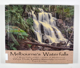
Book - Hardcover book, Travis Easton, Waterfalls of Victoria-Volume Three-Eastern Waterfalls, 2015
A book of photographs and information pertaining to the waterfalls in Eastern Victoria.A book of photographs and information pertaining to the waterfalls in Eastern Victoria.Hardcover. Front cover has a photograph of Toorongo Falls and back cover has a photograph of Evelyn Falls with a synopsis of the book.Gift fo Marysville & District Historical Society by Travis. 17 After catching up with my family because I had lingered to take a few more photographs,/ I was serenaded with the following song:/ Don't go chasing waterfalls/ Please stick to the rivers and the lakes that you're used to/ I know that you're gonna have it your way or nothing at all/ but I think you're moving too fast/ from the song Waterfalls by TLC Dedicated to my wife and children: Monique, Iona, Zahra, Jasmine & Flynn,/ who have continued to love me despite my waterfall chasing ways.waterfalls, eastern victoria, travis easton, photographs -
 Ringwood and District Historical Society
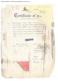
Document, Certificate of Title - Edward Thomas Miles, Gentleman, "Woorara", Ringwood - part of Crown Section 20, Parish of Warrandyte, County of Evelyn - 1913
A4 copies of damaged Landata Victoria Historical Search documents - Vol 3726 Fol 200 - incomplete proprietor and transfer details.Edward Thomas Miles is now the proprietor of an Estate in Fee-simple subject to the Encumbrances notified hereunder ... 27 acres 19 perches or thereabouts, together with a right of carriage way over roads coloured brown. Subdivision map includes un-named roads - western side is Wonga Road (later Warranwood Road), and eastern side is Grandview Grove (later Bemboka Road), both north of Plymouth Road, Ringwood, Vic. Transfers include (illegible) Dobbs, November, 1927 - 5 acres Harry Temple Marshall, 1st December, 1928 - 10ac 3r David Edward Meyland, 4th October, 194-? (illegible). -
 The Beechworth Burke Museum
Audio - Oral History, Jennifer Williams, John Watson, 22 June 2000
John Watson's story shows insight to the families that moved to Beechworth and the motivation behind this. It showcases the nuances of life in the district and the day to day ways of living. This history speaks of land cultivation and the innovation of industry in the region, in particular cattle farming and butchering. Watson's account speaks of the way that the practice of breeding cattle effects the rural lifestyle, and the hardships that come with working on the land. This oral history recording was part of a project conducted by Jennifer Williams in the year 2000 to capture the everyday life and struggles in Beechworth during the twentieth century. This project involved recording seventy oral histories on cassette tapes of local Beechworth residents which were then published in a book titled: Listen to what they say: voices of twentieth century Beechworth. These cassette tapes were digitised in July 2021 with funds made available by the Friends of the Burke.Watson's account is historically significant due to its ability to illustrate the lifestyle and industry of those in Beechworth during the twentieth century. It is a rare insight into the the practices of residents of this time. This oral history also shows deep insight into the social structure of the community. It describes the family and community dynamics over a long period of time, the motivations behind behaviour, and the greater community fabric. This is a digital copy of a recording that was originally captured on a cassette tape. The cassette tape is black with a horizontal white strip and is currently stored in a clear flat plastic rectangular container. It holds up 40 minutes of recordings on each side.John Watson1800s beechworth, 20th century beechworth, beechworth, farming and agriculture, farm, farm work, farmers, farming, cattle, industry, oral history, john watson -
 Flagstaff Hill Maritime Museum and Village
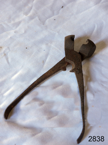
Lead Shot Mould
Bullets for early firearms were made as lead balls in iron scissor moulds. The moulds had scissor action, with ends shaped as a hollow half-sphere that formed a ball when the handles closed. Melted lead was poured into a small filling hole in the top of the closed mould. When the lead was set the handles were opened and the ball was released from the mould. Excess lead was trimmed using the cutting edge of the mould. The task of pouring the melted lead into the mould had to be performed slowly so that air pockets didn’t form. The shot would have a join line around it, which would make it inaccurate; the join needed to be carefully filed to make the ball into a smooth sphere. Larger quantities of lead shot were often cast in a multi-bullet mould that was used in a similar way. Lead shot mould; cast iron, scissor type metal object with sphere shaped mould at end used to make lead shot balls for a shotgun. Mould has a cutting edge to trim off excess lead.flagstaff hill, warrnambool, shipwrecked-coast, flagstaff-hill, flagstaff-hill-maritime-museum, maritime-museum, shipwreck-coast, flagstaff-hill-maritime-village, firearms, bullet, cast bullet, lead ball, lead shot, scissor mould -
 Warrnambool and District Historical Society Inc.
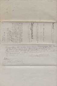
Document, Indenture A Bostock Esquire to Messrs Aitkin & Bostock( Ernest), 1865
The Bostock, Manifold and Aitkin families were all pioneering families in the Western District of Victoria almost from the time of settlement. They leased and owned vast tracts of land and operated businesses around the district, often associated with the farming industry. This document is dated 5th July 1865 and is an assignment of stock by way of mortgage. Augustus Bostock is the mortgagor with James William Manifold Aitkin and Ernest Bostock as mortgagees. At various times they were involved in running businesses together, in particular the Aitkin and Bostock store and flour mill. Three of the Bostock men were married to three of the Aitkin sisters. The amount in question is £2157/3/2 and surety is 8000 sheep and their increase, presently running at Coomete. The penciled in details on the document refer to Robert Brand Paterson who was later in business with Aitkin This is one of a number of documents which relate to the Bostock family who were one of the most important pioneering families of the Western District. They owned and leased various properties around Warrnambool and were involved in many aspects of social and business life. The document itself is indicative of its time and provides an insight into the details and terms of such documents at the time.Large grey coloured, lined hand written document over four pages. Folded in four with date and details on one section. Red wax seal on page 3. There are extra entries written in black lead pencil in areas relating to the money and surety of the agreement.Signed by the following George Barber Warrnambool, Thomas Sunderland Deputy Registrar General, and Augustus Bostock. Hingston & Co, Chancery Lane Melbourne hand written in top left hand corner. warrnambool, bostock,augustus bostock james william manifold aitkin,robert brand paterson, coomete, -
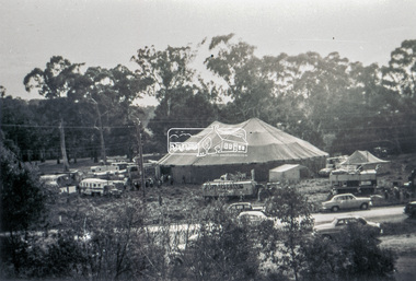 Eltham District Historical Society Inc
Slide - Photograph, Grace Mitchell, Ashtons Circus set up in Bremner's Reserve, Main Road, Eltham, c.1955
View from Grace Mitchell's shop at the corner of Mount Pleasant Road and Main Road. Grace Mitchell was probably best known for her Eltham shop at the corner of Mt Pleasant Road and Main Road. Grace's memories covered many local identities who were patrons of her shop between 1954 and 1971. From the elevated position of her shop and home Grace was able to view a varied passing parade of Eltham events from ERSILAC, Easter and Eltham Festival parades passing on their way to Eltham Lower Park, circuses in Wingrove Park (then Bremner’s Reserve), roadworks and other happenings. Bremner's Reserve was renamed Wingrove Park c.1970 This photo was from a series of images presented by Grace Mitchell at a Society talk 10 March 1993 on the theme of “My Eltham”.35mm Kodak 5052 TMX Black and White transparency, 1 strip, 6 frames Black and white print 17 x 25.4 cmashtons circus, bremner's flat, circus, grace mitchell, main road, mount pleasant road, wingrove park -
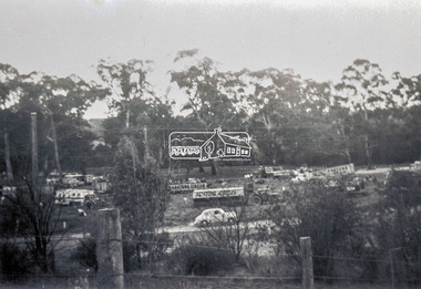
 Eltham District Historical Society Inc
Photograph, Grace Mitchell, Bremners Flat, Main Road, Eltham, 1958c
View from Grace Mitchell's shop at the corner of Mount Pleasant Road and Main Road. Grace Mitchell was probably best known for her Eltham shop at the corner of Mt Pleasant Road and Main Road. Grace's memories covered many local identities who were patrons of her shop between 1954 and 1971. From the elevated position of her shop and home Grace was able to view a varied passing parade of Eltham events from ERSILAC, Easter and Eltham Festival parades passing on their way to Eltham Lower Park, circuses in Wingrove Park (then Bremner’s Reserve), roadworks and other happenings. Bremner's Reserve was renamed Wingrove Park c.1970 This photo was from a series of images presented by Grace Mitchell at a Society talk 10 March 1993 on the theme of “My Eltham”.Black and white print 17 x 25.4 cmbremner's flat, main road, mount pleasant road, wingrove park -
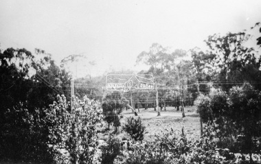
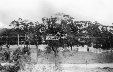 Eltham District Historical Society Inc
Photograph, Grace Mitchell, Diamond Creek in flood, Bremners Flat, Main Road, Eltham, c.1958
View from Grace Mitchell's shop at the corner of Mount Pleasant Road and Main Road. Grace Mitchell was probably best known for her Eltham shop at the corner of Mt Pleasant Road and Main Road. Grace's memories covered many local identities who were patrons of her shop between 1954 and 1971. From the elevated position of her shop and home Grace was able to view a varied passing parade of Eltham events from ERSILAC, Easter and Eltham Festival parades passing on their way to Eltham Lower Park, circuses in Wingrove Park (then Bremner’s Reserve), roadworks and other happenings. Bremner's Reserve was renamed Wingrove Park c.1970 This photo was from a series of images presented by Grace Mitchell at a Society talk 10 March 1993 on the theme of “My Eltham”.Black and white print 17 x 25.4 cmbremner's flat, diamond creek, floods, main road, mount pleasant road, wingrove park -
 Eltham District Historical Society Inc
Slide - Photograph, Grace Mitchell, Portable buildings on trucks possibly for installation at the Golden Fleece Service Station, corner of Main Road and Mount Pleasant Road, Eltham, c.1961
View from Grace Mitchell's shop at the corner of Mount Pleasant Road and Main Road. Grace Mitchell was probably best known for her Eltham shop at the corner of Mt Pleasant Road and Main Road. Grace's memories covered many local identities who were patrons of her shop between 1954 and 1971. From the elevated position of her shop and home Grace was able to view a varied passing parade of Eltham events from ERSILAC, Easter and Eltham Festival parades passing on their way to Eltham Lower Park, circuses in Wingrove Park (then Bremner’s Reserve), roadworks and other happenings. Bremner's Reserve was renamed Wingrove Park c.1970 This photo was from a series of images presented by Grace Mitchell at a Society talk 10 March 1993 on the theme of “My Eltham”.35mm Kodak 5052 TMX Black and White transparency, 1 strip, 6 frames Black and white print 17 x 25.4 cmgolden fleece service station, main road, mount pleasant road -
 Eltham District Historical Society Inc
Photograph, Grace Mitchell, Possibly the Ersilac Parade travelling along Main Road, Eltham, c.1958
View from Grace Mitchell's shop at the corner of Mount Pleasant Road and Main Road. Grace Mitchell was probably best known for her Eltham shop at the corner of Mt Pleasant Road and Main Road. Grace's memories covered many local identities who were patrons of her shop between 1954 and 1971. From the elevated position of her shop and home Grace was able to view a varied passing parade of Eltham events from ERSILAC, Easter and Eltham Festival parades passing on their way to Eltham Lower Park, circuses in Wingrove Park (then Bremner’s Reserve), roadworks and other happenings. Bremner's Reserve was renamed Wingrove Park c.1970 This photo was from a series of images presented by Grace Mitchell at a Society talk 10 March 1993 on the theme of “My Eltham”.Black and white print 17 x 25.4 cmcars, bremner's flat, eltham, ersilac parade, main road, mount pleasant road, wingrove park, festival, horse drawn carriage -
 Eltham District Historical Society Inc
Photograph, Grace Mitchell, Possibly the Ersilac Parade travelling along Main Road, Eltham, 1958c
View from Grace Mitchell's shop at the corner of Mount Pleasant Road and Main Road. Grace Mitchell was probably best known for her Eltham shop at the corner of Mt Pleasant Road and Main Road. Grace's memories covered many local identities who were patrons of her shop between 1954 and 1971. From the elevated position of her shop and home Grace was able to view a varied passing parade of Eltham events from ERSILAC, Easter and Eltham Festival parades passing on their way to Eltham Lower Park, circuses in Wingrove Park (then Bremner’s Reserve), roadworks and other happenings. Bremner's Reserve was renamed Wingrove Park c.1970 This photo was from a series of images presented by Grace Mitchell at a Society talk 10 March 1993 on the theme of “My Eltham”.Black and white print 17 x 25.4 cmcars, bremner's flat, eltham, ersilac parade, main road, mount pleasant road, wingrove park, festival, horse drawn carriage -
 Eltham District Historical Society Inc
Photograph, Grace Mitchell, Possibly the Ersilac Parade travelling along Main Road, Eltham, c.1958
View from Grace Mitchell's shop at the corner of Mount Pleasant Road and Main Road. Grace Mitchell was probably best known for her Eltham shop at the corner of Mt Pleasant Road and Main Road. Grace's memories covered many local identities who were patrons of her shop between 1954 and 1971. From the elevated position of her shop and home Grace was able to view a varied passing parade of Eltham events from ERSILAC, Easter and Eltham Festival parades passing on their way to Eltham Lower Park, circuses in Wingrove Park (then Bremner’s Reserve), roadworks and other happenings. Bremner's Reserve was renamed Wingrove Park c.1970 This photo was from a series of images presented by Grace Mitchell at a Society talk 10 March 1993 on the theme of “My Eltham”.Black and white print 17 x 25.4 cmcars, bremner's flat, eltham, ersilac parade, main road, mount pleasant road, wingrove park, festival, horse drawn carriage -
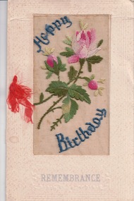 Lara RSL Sub Branch
Card, Happy Birthday Card
The silk card were created by French women during the First World War. The women would create these in there homes as a way to earn an income during the tuff times. The silk mesh was embroidered by the women and was later sent to factories to be placed on the cards. According to the Australian war memorial website there were 10 million of the cards made between 1914-1919. This card in particular was sent from John (Jack) McIntyre to his mother for her birthday. J. McIntyre served in the first world war, first arrived in Egypt in 1915, then to the Western front in France in July 1916. He was servery injured during his time in France and was sent to the Hospital in England. After the war finished Jack travelled back to Australia and lived in Lara with his brother and sister.This card is significant as it is a reflection on the communication between families during the First World War. It also is a symbol of the way women in France made their money during the tuff timesA birthday card with silk on the front of the card. It has pink flowers stitched into the silk and says 'happy birthday'On the front it has 'Happy Birthday" "Remembrance" On the first page in the inside "Remembrance" "To mother" "From Jack" "France 1918" On the second page in the inside: "Wishes are nothing; t'is the heart That in the few lines dwells And says to those from us apart More that the greeting tells" birthday card, mother, son, mcintyre, world war 1, ww1, happy birthday, handmade, silk, embroidered -
 Federation University Historical Collection
Book - Booklet, Soldiering On: The Australian Army at Home and Overseas, 1942
Belonged to Clarence (Clarrie) Edward Nicholls who was a communications person on the Sunderland Flying Boats. He was in the Battle of Britain. He was seconded to the RAF and flew out of Plymouth. He was shot down a number of times. He was in the peace keeping corps in Japan and then Korea, and then went into the full time Korea. At one time Clarrie and his two brothers were in New Guinea at the same time. They knew they were all there together but they could not find each other, and officials would not tell them where they were. He flew the last Sunderland back to Lake Boga. He wanted to buzz his parents in Wodonga so he knew he was on the way, but the authorities wouldn't let him. Clarrie Nicholls was a flag bearer for the Melbourne Olympics.Red hard covered book of 200 pages. The following images are by official war artist Geoff Mainwaring (SX13471) who later taught painting at the Ballarat Technical Art School. * 'And Again. So-Heave', page 121 * 'Day's Work Done', page 121 * Untitled image, pg 185 Includes photographs of General Sir Thomas Blamey, Corporal Jim Gordon, John Lavarack, Iven Maccay, Australian Women's Army Service, Convalescent Diggers at Heidelberg Hospital; and maps of the Malay Peninsula and Singapore.clarence nicholls, nicholls, world war 2, geoffrey mainwaring, new guinea, singapore, libya, solomon islands, charles bush, ivor heale, g.j. browning -
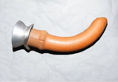 J. Ward Museum Complex
Functional object - Hewitt's Airway, Unknown
Hewitt’s airway was the first known oral airway and laid the foundations for the numerous other airways that were later developed. The development of the oropharyngeal airway is one of the lesser-acknowledged advances in anaesthesia. Oral airways made anaesthesia safer and significantly reduced the trauma associated with earlier attempts at managing the obstructed airway. The Hewitt Airway – the first known artificial oral ‘air-way’. In 1890, Frederic Hewitt noted the frequency and danger of upper airway obstruction. In 1908, dissatisfied with the use of tongue forceps and that Esmarch’s maneuver sometimes failed, he described the first oropharyngeal airway, the Hewitt Airway. The tube was less than 8 cm long, ideally connecting the oral opening to the hypopharynx. The Hewitt Airway was the foundation for many subsequent oropharyngeal airway designs.The oropharyngeal airway is significant because of its lesser acknowledged advances in anaesthesia.Round metal tube with a brown rubber tubing sleeve around the outside.medical health, anaesthesia -
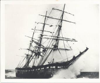 Phillip Island and District Historical Society Inc.
Photograph, The Speke, 22/02/1906
The Speke was an all steel ship of 310 feet, beam of 35 feet and weight of 2,712 tons and triple masted. She was built in 1891 at Carnarvon in Wales for a cost of 22,000 pounds. The wreck of the Speke was purchased for a mere 12 pounds after it went aground in 1906. The Speke had come from Peru to Sydney. She was then on her way to load wheat in Geelong when she ran aground on the 22 February 1906. Captain Tiltson confused a bushfire, near Cowes, for navigation lights. The ship drifted close to shore in Kitty Miller Bay and was eventually holed at 3 pm on the rocks. Life boats were immediately lowered and the ship’s crew all made it to shore except Seaman Frank Henderson, who lost his life.Black & White photograph of The Speke running aground on the south coast of Phillip Island.wreck of the speke, the speke, jack loney -
![Photograph - Digital image, Kelly Garden Supplies [Greensborough], 02/05/2013](/media/collectors/4f729f5697f83e03086015b8/items/5729bced2162f108e8de6b52/item-media/5729bd212162f108e8de74aa/item-fit-380x285.jpg) Greensborough Historical Society
Greensborough Historical SocietyPhotograph - Digital image, Kelly Garden Supplies [Greensborough], 02/05/2013
This photograph of the former site of Kelly Garden Supplies was taken in 2013 to show changes over 40 years, based on Ron Reynold’s sketches in the 1973 publication “Greensborough and Greenhills” published by Cypress Books. The site is now part of the Civic roundabout at the top of the Greensborough By-pass. Civic Drive was associated with the building of Diamond Valley Council Offices opened by Governor Rohan Delacombe on 26/2/1972. Previously it was known as Kelly's Track which wound its way around to a house that overlooked the aqueduct bridge. Kelly's Sandpit (quarry) was the local go to place to obtain road, driveway fill and red sand for local construction. For 80 years previous Kelly's quarry supplied sand to the greater Melbourne area for the surfacing of school grounds, parks etc. Digital copy of colour photograph.greensborough and greenhills, civic drive greensborough, kelly garden supplies, ron reynolds -
![Photograph - Digital image, Willis Vale [2], 1950c](/media/collectors/4f729f5697f83e03086015b8/items/54fd41442162f10d30bf885f/item-media/54fd41912162f10d30bf8caa/item-fit-380x285.jpg) Greensborough Historical Society
Greensborough Historical SocietyPhotograph - Digital image, Willis Vale [2], 1950c
View of Greensborough in the distance from Willis Vale and surrounding land: House built by Edward Maygar, The flowering Hawthorne Bushes were planted by William Partington. Note the prominent house on upper right where Robert Whatmough lived in the mid 19th century and later sold to Partington family. It was located on the Plenty River across from Partington's Flat. The derelict Willis Vale house was destroyed in 1964 when a fire originating from North Plenty Gorge - Kurrak Road - was lit by two teenage boys and made its way several kilometres down to Partington's Flat Greensborough. In 1946, Alan Partington built the Alwyn Farmhouse in place of the original Robert Whatmough home seen in this photo which became Whatmough Park circa 1976.Home of the Partington familyDigital copy of black and white photograph.willis vale, partington family, maygar family, whatmough -
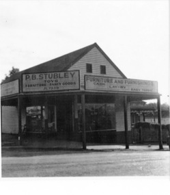 Greensborough Historical Society
Photograph - Digital image, Stubley's Furniture, 1958c
Stubley's Furniture Store late 1950s. The Stubley Group began in 1946 when Purcell Stubley purchased a site with petrol bowsers in Main Street from 'Snowy' Jessop. In 1948 Purcell began building the new Stubley Motors, working round the old site to keep the business operating. It was completed in 1951. The Group expanded into other areas such as this Furniture store. [Syd Thompson Fruit Shop was here in early 1950s, Syd lived in the house at back. He coached Boxing]. This became the Welkay Store in the 1960's and owned by Walter Kenyon. The Welkay store moved opposite to 100 Main Road on 6/9/1966, ref: Diamond Valley News Page 9. Soon after the store would have been demolished to make way for 'The Valley Building' still on the site in 2018.Digital copy of black and white photographpurcell stubley, stubley motors, stubley group greensborough -
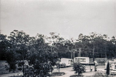
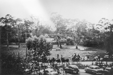
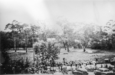
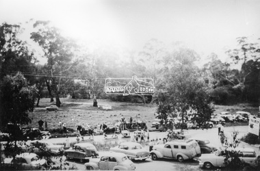
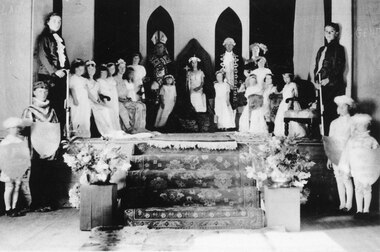 Halls Gap & Grampians Historical Society
Photograph - B/W, C 1934
This is a photo of the "Queen Competition", probably the best remembered entertainment of the 1930's. Four local lasses were chosen to represent the following: Bellfield Hotel, Grampians House, The Cricket Club and the Grampians Mountains. When the long awaited evening came each Queen and her attendants paraded through the hall, the results were announced and the winner (who this year was Valerie Evans) took her place on a throne erected in the middle of the stage. The other Queens made their way to thrones on either side of her. The audience were treated to a right royal display as the "Bishop" placed a crown on the winner's head. Much merriment followed including a play, with students dressed as Minnie and Mickey Mouse and other Disney characters. For the names of the people in the photo refer to "Bridging the Gap" by Ida Stanton, p.88. The photo shows a group of people arranged on and below a dais. There is a woman dressed as royalty sitting on a throne in the centre, flanked by a man dressed as a bishop on the left and a man dressed as a courtier on the right. There are two young girls in long white dresses wearing flowered bands in their hair standing in front of the men. There are more girls in white dresses and flower bands along both sided of the dais and two youths wearing ruffle fronted shirts and holding batons/walking sticks(?) at the front of each row of girls. Carpeted steps lead down from the dais and in front of the dais on either side are two boys dressed as pages. Flower arrangements flank the foot of the stairs.recreation, entertainment -
 Kiewa Valley Historical Society
Photograph of Kiewa Valley Panorama, Farming lands within the Kiewa Valley in1950s, Circa 1950
This photograph shows how (early to mid1900s), before the establishment of the Mount Beauty "gated" village, the Kiewa Valley was farmed and the scarce population was spread out over acres of productive land. This photograph catches a time before (what appeared to the local farmers as the invasion by a mass of construction workers) when this remote valley was part of a "lay back" rural landscape,occasionally visited by friends and some wayward tourists. The mountain ranges provided an adequate barrier against the way-would traveller. The immigration numbers coming into Australia was still quite small ( due to the "white" Australia policy) which was in force before World War II. After World War II a mass of displaced European refugees and migrants boosted the Australian population and provided for a greater degree of diverse professions and rural related work force.This photograph depicts the borderline in time between an exclusively rural based population and respective activities(early 1900s)to the present (2000 on wards) integrated village, tourist and retiree/holiday area. The time when land was exclusively used in agriculture is over and the impact of cheaper rural produce from Asian markets will see a shift of land useage and population activities. The Kiewa Valley is loosing its hiding place and is becoming more and more a source of untapped residential land. Black and white photograph of farming/grazing land useage, before the establishment of the Mount Beauty Village. Small pockets of residentual houses can be viewed. Road access (unsealed dirt) was typical of that provided in rural regions in the 1950s. The photo is on 200gms paper and not on photographic paper.kiewa valley in the early1900s, grazing in the kiewa valley, sec victoria