Showing 10832 items
matching maps
-
 Koorie Heritage Trust
Book, C. E. Sayers (Original edition edited by Bride, Thomas Francis), Letters from Victorian pioneers : a series of papers on the early occupation of the colony, the Aborigines, etc. addressed by Victorian pioneers to His Excellency Charles Joseph La Trobe, Esq., Lieutenant-Governor of the Colony of Victoria, 1983
Brief notes on the contributors and incidents have been included in this edition although the above-mentioned items have been left out, some marginal notes made by Governor La Trobe have been dealt with in the footnotes. "From the original edition edited for the Trustees of the Public Library by Thomas Francis Bride'. Previously published: Melbourne : Heinemann, 1969. Originally published: Melbourne : Government Printer for the Trustees of the Public Library, Museums and National Gallery of Victoria, 1898.xiv, 455 p., 31 p. of plates : map ; 26 cm.Brief notes on the contributors and incidents have been included in this edition although the above-mentioned items have been left out, some marginal notes made by Governor La Trobe have been dealt with in the footnotes. "From the original edition edited for the Trustees of the Public Library by Thomas Francis Bride'. Previously published: Melbourne : Heinemann, 1969. Originally published: Melbourne : Government Printer for the Trustees of the Public Library, Museums and National Gallery of Victoria, 1898.pioneering, 1836-1854. victoria. correspondence, diaries, etc. | victoria. description & travel, 1836-1854. correspondence, diaries, etc. | frontier and pioneer life -- victoria. | victoria -- history -- 1834-1900 -- sources. | victoria -- description and travel -- 1851-1900. -
Koorie Heritage Trust
Book, Osborn, Betty, The Bacchus Story : A history of Captain W. H. Bacchus of Bacchus Marsh, and his son, 1973
xi-xiv; 118 P.; maps; notes; facs.;21 cm.bacchus family. | bacchus family. victoria. bacchus marsh, 1837-1907. -
Koorie Heritage Trust
Book, Barlow, Alex et al, My mob : the story of Aboriginal family life, 2001
Looks att he traditional family pre-contact and the disruption caused by European contact. lAlso looks at Aboriginal families today.32 p. : ill. (some col.), map, port. ; 28 cm.Looks att he traditional family pre-contact and the disruption caused by European contact. lAlso looks at Aboriginal families today.aboriginal australians -- history -- juvenile literature. | families, aboriginal australian -- juvenile literature. -
Koorie Heritage Trust
Book, Balla, Trace, Rivertime, 2014
Based on the author's journals and sketches of a bird-watching trip on the Glenelg River. A tender and beautifully illustrated tale of a boy and his bird-watching uncle, on a paddling trip on Australia's Glenelg River. A story about slowing down, growing up, and connecting with the land and its creatures.78 pages : colour illustrations, map ; 20 x 27 cmBased on the author's journals and sketches of a bird-watching trip on the Glenelg River. A tender and beautifully illustrated tale of a boy and his bird-watching uncle, on a paddling trip on Australia's Glenelg River. A story about slowing down, growing up, and connecting with the land and its creatures.animals -- victoria -- glenelg river -- juvenile fiction. | canoes and canoeing -- juvenile fiction. | bird watching -- victoria -- glenelg river -- juvenile fiction. | bird watching -- victoria -- glenelg river -- comic books, strips, etc. | animals -- victoria -- glenelg river -- comic books, strips, etc. | canoes and canoeing -- comic books, strips, etc. | graphic novels. | glenelg river (vic.) -- juvenile fiction. | glenelg river (vic.) -- comic books, strips, etc. | australian -
Koorie Heritage Trust
Booklet, Public Record Office Victoria, Walata tyamateetji - a guide to government records about Aboriginal people in Victoria, 2014
This guide is designed to help researchers find records about Aboriginal people in Victoria in both the Public Reccords and Nationl Archives. It focuses on records that are specifically about Aboriginal people and issues, and inclues records created by the various government agencises overseeing the administration of Aboriginal affairs in Victoria. Public Record Office Victoria and the National Archives of Australia hold many government records about Aboriginal people in Victoria. This guide is designed to help Victorian Aboriginal people find records about their family and country. It will also assist anyone researching the history and administration of Aboriginal affairs in Victoria to find relevant records.87 pages : illustrations (some colour), maps, facsimiles ; 30 cm.This guide is designed to help researchers find records about Aboriginal people in Victoria in both the Public Reccords and Nationl Archives. It focuses on records that are specifically about Aboriginal people and issues, and inclues records created by the various government agencises overseeing the administration of Aboriginal affairs in Victoria. Public Record Office Victoria and the National Archives of Australia hold many government records about Aboriginal people in Victoria. This guide is designed to help Victorian Aboriginal people find records about their family and country. It will also assist anyone researching the history and administration of Aboriginal affairs in Victoria to find relevant records.aboriginal australians -- victoria -- history -- sources -- bibliography. | public records -- victoria -- bibliography. | aboriginal australians -- victoria -- archives. | archives -- victoria -- catalogs. | aboriginal australians -- victoria -- government relations -- history. | archives and archiving - manuscripts and records. | libraries - reference materials - bibliographies australian -
Koorie Heritage Trust
Book, Baragwanath, W, Memoirs of the Geological Survey of Victoria : No. 15 The Aberfeldy District, Gippsland, 1925
15 v. : ill., plates, maps, plans, diagrs. ; 34 cm. lcsh: 1. geology -- victoria -- periodicals. 2. geology -- victoria. i. geological survey of victoria. ii. victoria. dept. of mines. -
Koorie Heritage Trust
Book, Blanks, Harvey, The Story of Yea : a 150 year history of the shire, 1973
Contents: Foreword; Preface; Prologue: The Dreamtime; Hume & Hovell's expedition; The coming of the overlanders; The first settlers; The Muddy Creek Aborigines; Early families & personalities; The settling of Highlands; Muddy Creek becomes Yea; Early teething troubles; The Road Board years; A bridge over troubled waters; From Mission to Church; The Shire - 1876 to 1900; Soldiers of the Queen; Into the New Century; How education came to Yea; Through Two World Wars; The Post-War Years; Appendices; Index.311 p., [16] p. of plates. : ill., maps. ; 22 cm.Contents: Foreword; Preface; Prologue: The Dreamtime; Hume & Hovell's expedition; The coming of the overlanders; The first settlers; The Muddy Creek Aborigines; Early families & personalities; The settling of Highlands; Muddy Creek becomes Yea; Early teething troubles; The Road Board years; A bridge over troubled waters; From Mission to Church; The Shire - 1876 to 1900; Soldiers of the Queen; Into the New Century; How education came to Yea; Through Two World Wars; The Post-War Years; Appendices; Index.other: yauung-illam-baluk tribe -- taungurong -- local history -- yea -- muddy creek -- goulburn river. -
Koorie Heritage Trust
Book, Blainey, Geoffrey, A land half won, 1980
...covers the second phase of Australia's history from the coming of the first fleets to the long drought and depression which ushered in the new Commonwealth in 1901.v, 388 p., [12] p. of plates : maps ; 22 cm....covers the second phase of Australia's history from the coming of the first fleets to the long drought and depression which ushered in the new Commonwealth in 1901. australia. social conditions, to 1900. | australia -- social conditions -- 1788-1900. -
Koorie Heritage Trust
Pamphlet, Aboriginal History Programme, Lake Condah Mission, 1984
Includes: History of Lake Condah; Lake Condah Mission men; The stones; Lake Condah School; Some People of Lake Condah, 1876-1912; The Births, Deaths and Marriages after the Mission had closed.1 folded sheet (6 p.) : ill., map ; 21 cm.Includes: History of Lake Condah; Lake Condah Mission men; The stones; Lake Condah School; Some People of Lake Condah, 1876-1912; The Births, Deaths and Marriages after the Mission had closed.lake condah mission - history -
Koorie Heritage Trust
Booklet, Broome, Richard, Aboriginal People of Victoria, 1990
15 p. : ill. (some col.), map, ports. ; 30 cm.aboriginal australians -- victoria. -
Koorie Heritage Trust
Journal - Serials, Department of Pacific and Southeast Asian History, Australian National University, Aboriginal History - Volume 05. 1-2 1981, 1981
Articles on various aspects of Australian History articles.178 p.; ill.; tables; footnotes; bibs.; maps; 25 cm.Articles on various aspects of Australian History articles.aboriginal australians -- periodicals. | ethnology -- australia -- periodicals. | settlement and contacts - chinese | language - change | mining industry - gold | settlement and contacts - afghans | animals - mammals - camels | race relations - racism - stereotyping | language - texts and translations - aboriginal to non-aboriginal language | art - drawing | art - artists | settlement and contacts - macassans and indonesians | language - kriol | language - linguistics - language classification | language - semantics | settlement and contacts - explorers | -
Whitehorse Historical Society Inc.
Document, East Burwood reserve, 1992
History and map of East Burwood Reserve - includes details of acquisition of landHistory and map of East Burwood Reserve - includes details of acquisition of landHistory and map of East Burwood Reserve - includes details of acquisition of landcity of nunawading, east burwood reserve, burwood highway, burwood east, nos 292 - 336 -
 Whitehorse Historical Society Inc.
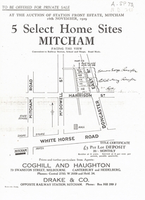
Document, 5 Select Homes Sites Mitcham, 16/11/1929 12:00:00 AM
Auction of land in Mitcham.Auction of land in Mitcham. Includes schetch map of locations and names of purchasersAuction of land in Mitcham. auction, station front estate, mitcham road, mcdowell street, doncaster east road, whitehorse road, coghill & haughton estate agents, drake & co estate agents, roeszler, norman george, edith mary, reid harrison street -
 Whitehorse Historical Society Inc.
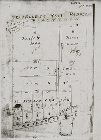
Pamphlet - Map, Travellers Rest Paddock
Map of Travelers' Rest Paddock, Blackburn subdivisionMap of Travellers Rest Paddock, Blackburn subdivision with frontage in Whitehorse RoadMap of Travelers' Rest Paddock, Blackburn subdivisionwhitehorse road, blackburn, travellers rest paddock, williams road, bayley, leonard sherwin, pearce, land subdivision -
Whitehorse Historical Society Inc.
Document, List of schools in the city of Nunawading, 1969
List of schools in the City of Nunawading and hand drawn map showing locations.city of nunawading, schools -
 Whitehorse Historical Society Inc.
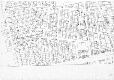
Map, Cadastral map, ca 1955
Cadastral map showing house and lot numbers (ca 1955) in Mitcham.plans, ormond avenue, mitcham, hardwood court, bruce street, page street, victoria avenue, mitcham road, whitehorse road, dunlavin road, doncaster east road, harrison street, william street, alexander street, fellows street, peel street, milne street, albert street, edward street, shirley court, burnett street, haines street -
Whitehorse Historical Society Inc.
Pamphlet, Getting about Nunawading, 1990's
Maps of schools, parks, bicycle and public transport routes in the City of Nunawading.Maps of schools, parks, bicycle and public transport routes in the City of Nunawading.Maps of schools, parks, bicycle and public transport routes in the City of Nunawading.public transport, city of nunawading -
Whitehorse Historical Society Inc.
Document, Heritage Precincts Report 2004, 2004
Heritage Precincts report 2004, City of Whitehorse, with photos and maps of the precincts.Heritage Precincts report 2004, City of Whitehorse, with photos and maps of the precincts.Heritage Precincts report 2004, City of Whitehorse, with photos and maps of the precincts.mount view court precinct, burwood, blacks estate precinct, mont albert, thomas street precinct, mitcham, windsor park estate precinct, surrey hills -
 Ballarat Tramway Museum
Map, Electric Supply Co. of Vic (ESCo), Ballarat Electoral Map - ESCo, 1900
Document prepared by the Electric Supply Co of Victoria, as part of an order under the Electric Light and Power Act 1896, section 5 of order No. 17 granted to company. Dated 19/2/1901 and signed by the Postmaster-General. Shows the order area being parts of the City of Ballaarat, Sebastopol and Ballarat East. Shows the street names, boundaries, principal power line routes, land reserves, parks, mine locations, railways and Lake Wendouree. Signed by R L Williams Town Clerk City of Ballarat, J R Hall for the Borough of Sebastopol, and John Gent for the Town of Ballarat EastYields information about the power supply to the Ballarat area.Cloth backed paper map, coloured and marked up as exhibit 17.Notes in ink including the signature of Benjamin Deakin 24/9/00 and certified by the three involved municipal Town Clerks.ballarat power supply, esco, electric supply co of victoria, city of ballaarat, east ballarat, sebastopol, orders, power lines, power supply -
 Colac RSL Sub Branch
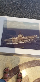
Photograph - Photograph of HMAS Melbourne in a presentation folder, Presentation folder
Photograph of the Australian Aircraft Carrier HMAS MelbourneHigh. Australia does not have an aircraft carrierGray coloured presentation folder with a photo of HMAS Melbourne and map inside Coloured photo of HMAS Melbourne -
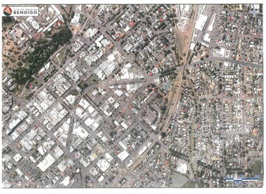 Bendigo Historical Society Inc.
Map - BENDIGO MAP AERIAL VIEW
Map of Bendigo. Aerial View of Bendigo. Published by City of Bendigo. Undated.photograph, aerial, bendigo -
 Kew Historical Society Inc
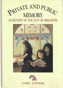
Book, Private and Public Memory: a history of Malvern / by Lynne Strahan, 1989
[vi], 289 p., [40] p. of plates : ill., maps, ports.malvern (vic) - history -
 Kew Historical Society Inc
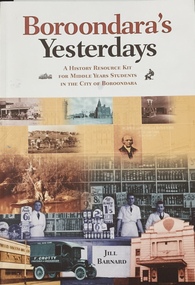
Book, Jill Barnard, Boroondara's Yesterdays, 2009
An educational resource for Middle Years students about the history of the City of Boroondarav, 89 p. : ill., facsims., maps, ports. ; 30 cm. non-fictionAn educational resource for Middle Years students about the history of the City of Boroondaraboroondara - history - kew - hawthorn - canterbury - camberwell - surrey hills - ashburton -
University of Melbourne, Burnley Campus Archives
Map (item), Proposed Reserve for Horticultural & Experimental Garden in the Survey Paddock. Clement Hodgkinson Deputy Surveyor General, 1862
horticultural & experimental garden, survey paddock, clement hodgkinson -
 Falls Creek Historical Society
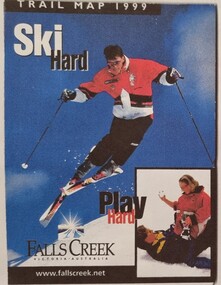
Booklet - Falls Creek Cross Country Trail Guide 1999
This publication was developed by the Falls Creek Resort Management Committee to promote activities and facilities at Falls Creek for the Winter Season 1999. It was a publication specifically focused on cross country skiers. This item is significant because it illustrates how Falls Creek has been marketed and promoted over time.A coloured fold out trail guide including a map of all trailsfalls creek trails, falls creek marketing, falls creek promotion, cross country skiing -
Canterbury History Group
Document - School Project: Elgar's Special Survey, Tudehope, Jennifer, 1963
Well researched essay on the background of Elgar's Special Survey. Includes mapcanterbury, elgar> henry t., land surveys, boroondara, campbell> j & r, dacre> r, towns> r., sea> h., dyce> a., mccarthy> w.g., shenley> james, henty's paddock, norris> j.r., maling> j, canterbury road, survey road, boroondara roads board, camberwell historical society, mont albert road, brooks> r., land subdivisions -
Camberwell Historical Society
Book - Photocopied pages from book, Bonwick, James, A Sketch of Boroondara, 1858
Photocopy of 11 pages, including a map, from James Bonwin's bookcamberwell, boroondara -
 Wodonga & District Historical Society Inc
Booklet - The Vanished Village - Ebden Weir / Mitta Junction, Lyn Larkin, 2004
This publication tells the story of the village of Mitta Junction which was established in about 1920 on the Victorian side of the Hume Dam construction site. The town was built to house workers and their families during the construction of the Hume Weir. It included houses, a shop, hall and school as well as tennis courts. After the completion of the weir the village and all its contents was sold at auction in June 1936 for £7000. The Mitta Junction school continued to operate until the mid 1980s. The book also documents aspects of the history of the Clark family of Bonegilla.A small publication by a local author. A4 size including photographs and a map.This publication tells the story of the village of Mitta Junction which was established in about 1920 on the Victorian side of the Hume Dam construction site. The town was built to house workers and their families during the construction of the Hume Weir. It included houses, a shop, hall and school as well as tennis courts. After the completion of the weir the village and all its contents was sold at auction in June 1936 for £7000. The Mitta Junction school continued to operate until the mid 1980s. The book also documents aspects of the history of the Clark family of Bonegilla.mitta junction township, hume weir construction, clark family bonegilla -
 Heidelberg Golf Club
Book, Melbourne Parks and Waterways, Lower Plenty River concept plan: Maroondah Pipe Track to Yarra River, 1994
Lower Plenty River concept plan: Maroondah Pipe Track to Yarra River. Includes suggestion of Plenty River Trail along the west boundary of the Heidelberg Golf Club.66 p., illus., colour map. Also, Draft copy of document.plenty river trail, lower plenty river, heidelberg golf club, mmbw, melbourne parks and waterways -
Broadmeadows Historical Society & Museum
Map - Map of Australia, John Bartholomew & Son Ltd, Contour- coloured world map series: Australia, c. 1955
Printed 1955Quality Map in good condition, can be used for research purposesMap of Australia - Colour contoured - printed on cloth, scale 1:5,000,000australia, map, historical information, education