Showing 15583 items
matching stillwell-valley
-
 Kiewa Valley Historical Society
Book - Craft, Dressmaking Made Easy, 1958
Tawonga C.W.A. was involved in dressmaking and other home industries.The Tawonga branch of the C.W.A. commenced on the 7th Feb. 1946 and often combined activities with the other branches in the Kiewa Valley. The C.W.A. aimed to improve health, welfare and education for women and children in the country. This was achieved by getting together and exchanging ideas on dressmaking while providing for their families and the local community, possibly selling their products at fetes.Women living in Tawonga were mostly on farms and, in 1946, when the branch commenced would have been feeling more remote with WW11 having an effect on available workers and the well being of the women and children.Small white and grey book with picture of tape measure and cotton reel on the cover. It has 15 pages including the cover which is printed on too. It has general instructions for sewing. Held by 2 staplesCover: Woman's Realm presents / Dressmaking / made easy / Simple instructions and / step-by-step diagrams for / making your own clothes tawonga. country woman's association of victoria. dressmaking. woman's realm. c.w.a. -
 Kiewa Valley Historical Society
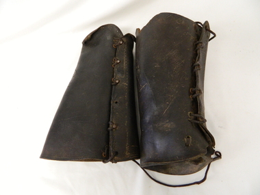
Gaiters Riding, Late 19th Century
These gaiters where used circa 1800's to mid 1900's, by horse riders "cattle men" to protect their shins and long trousers against wear and tear. They were used rather than having expensive boots damaged. Gaiters were a lot easier to fasten and clean than boots. They were used in the Kiewa Valley and the High Plains grazing areas.These gaiters were part of a cattleman's "out fit". The Gaiters were easily cleaned and did away with expensive riding boots. They were used throughout the valley and high plains areas both by horse riders herding cattle and the recreational rider of both sexes. After the 1950s more recreational riders from Melbourne ventured onto the high plains and not so rugged mountain slopes. Small settlements such as Mount Beauty, Bogong village and Falls Creek provided a secure backdrop for short term horse back adventures. The increasing pressure of city life provided a greater flow of stressed out city dweller to find the peace and quiet that city life does not have. Horse riding preceded the modern trail bikes and other recreational vehicles of the late 1900s. Thick leather tapered gaiters with six metal Hooks and Leather lacing through metal eyelets. All bar two eyelets have a metal reinforced punch holes. Left gaiter missing most of lacing.horse, country, leather, gaiters, high, grazing, cattlemen, laces, studs -
 Kiewa Valley Historical Society
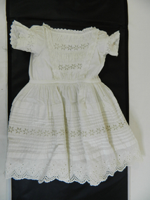
Dress Child
The dress was probably worn at a christening in one of the Kiewa Valley churches (denomination unknown). The importance of the event to family and friends is shown by the quality of the garment. These style Christening dresses were often worn buy several children of the one family , both boys and girls. Other items such as hand made bonnet may have been part of this out fit. "KVHS 0123" The quality of the garment and the fashion style it represents is both historical, not only the time of its manufacture but also of the fashion in that era. It has christian religious implications and values of the time frame of regional life in the early1900s. Girl's white dress (christening event), fine cotton with lace border "broderie anglaise" with a row of lace flowers mid skirt "battenberg".This lace is also inserted in centre front panel and sleeves. Scolloped cotton is also on sleeves, neck and front. Pin tucked skirt. Opening back with drawstring fastening at neck and waist. Short sleeves and machine stitched children clothing, lace-battenberg and broderie anglaise, female clothing, dress, cotton, christening, dressmaking -
 Myrtleford and District Historical Society
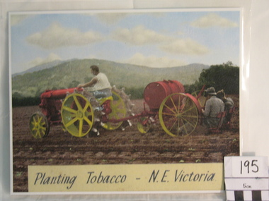
Colourized Photograph, "Planting Tobacco N.E. Victoria
The photograph depicts the 2nd important stage in tobacco growing--transplanting seedlings into open paddocks. It depicts early post-war machinery in use at the time until affordable modern tractors were available. The planting machine has probably been adapted from the horse-drawn era pre-World War 2. The scene is one near Myrtleford in the Ovens Valley.The photograph depicts the slow adaptation of modern tobacco farming methods in the immediate post-war period and the type of terain suitable for tobacco growing. The labour intensive nature of tobacco planting is also depicted.A colourized photograph of tobacco planting activity in a paddock near Myrtleford.Inscription: Planting Tobacco N.E. Victoria"tobacco farming tobacco planting machinery -
 Hume City Civic Collection
Photograph, 1/08/1980
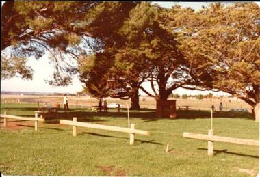
On 4th August 1978 the construction of the Goonawarra Estate commenced. The estate was formerly known as the Goonawarra Farm and overlooked the Sunbury farm and the Jacksons Creek valley. Plans for the new development included a golf course, houses, community and recreational facilities. The golf course opened in 1980 and the housing construction continued throughout the last two decades of the twentieth century and into the twenty first century.A coloured photograph of a barbecue and picnic area at Goonawarra. The photograph shows the Stage 3 development of the area.goona warra golf club, goonawarra farm, goonawarra housing estate, sharkey, robert b., kilkenny homes, craftsmen homes., australian ideas homes pty.ltd., glamor homes, villa bella homes, george evans collection -
 Ambulance Victoria Museum
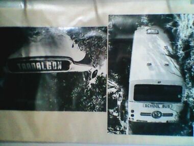
Photographs, bus crash, 24 June 1981
Latrobe Valley Bus lines school bus crash on 24 June 1981. 15 people were injured. Car 622 (G. Mason), Car 611 (C. Bruce), Car 624 (J. Budden and P. La Roche), Car 606 G. Cross attended and transported. Car 623 N. Akers co-ordinated. Source caption on labelSeries of four back and white photographs of bus crash mounted on folio two sheets of sized paper glued back to back.school bus latrobe valley, . budden, . g. mason, . c. bruce, . p. la roche, . g. cross -
 8th/13th Victorian Mounted Rifles Regimental Collection
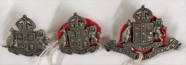
Badge - 7th LH badge
The 7th Australian Light Horse (VMR) was raised from companies of the pre-federation Victorian Mounted Rifles mainly in the central area of Victoria and the Goulburn valley. In 1912 it was renumbered 15th Light Horse with the motto Pro Rege et Patria and retaining the territorial title Victorian Mounted Rifles. Following World War One the regiment was renumbered 20th Light Horse (VMR)Hat badge and two collar badges of the 7th Light Horse (VMR) Regiment. Badges have a red fabric backing.light horse, 7th, goulburn valley, vmr -
 8th/13th Victorian Mounted Rifles Regimental Collection
Badge - 20 LH badge
The 7th Australian Light Horse (VMR) was raised from companies of the pre-federation Victorian Mounted Rifles mainly in the central area of Victoria and the Goulburn valley. In 1912 it was renumbered 15th Light Horse with the motto Pro Rege et Patria and retaining the territorial title Victorian Mounted Rifles. Following World War One the regiment was renumbered 20th Light Horse (VMR)Tqo lapel badges with red fabric backing of the 7th Light Horse Regiment (VMR).goulburn, vmr, 20th, light horse -
 Melbourne Legacy
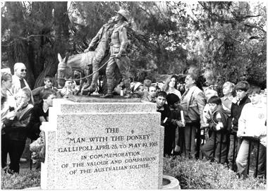
Photograph - Photo, Anzac commemoration for students 1992, 1992
A Legacy ceremony at the Shrine of Remembrance, during one of the annual "Anzac Commemoration Ceremony for Students" events, usually held just prior to ANZAC Day. The photo shows school students and veterans around the statue of "The Man with the Donkey". From an article in The Answer in May 1992, the caption reads 'Norm Stewart (right) of Yarra Valley relates the moving story of Simpson and his Donkey.A record of a ceremony at the Shrine and a Legatee speaking to the school children.Black and white photo of school children at the "The Man with the Donkey" statue.anzac commemoration for students, wreath laying ceremony -
 Kew Historical Society Inc
Photograph - Flooding of the Yarra River in North Kew, 1934
North Kew, now divided between Kew and Kew East, bordered the Yarra River. As such, it was a region subject to flooding in the Yarra Valley. Development beyond this point (ie Kellett Grove) was limited by the City of Kew's planning regulations. Prior to urban development, the area since European settlement and the first land sales in the district in the 1840s, had been used for dairy farming. Small sepia snapshot taken from the river ramp of a house at 8 Kellett Grove, in what was then known as North Kew. The point of view is from a backyard looking towards Fairfield. Beyond the fence line are two almost submerged houses. A number of people are in a motor driven boat midstream. Fairfield at this period, (ie 1934) was noted for its limited river side development. Verso: 2/12/34 / TAKEN FROM OUR RAMPyarra river -- north kew, floods -- yarra valley, floods -- north kew, floods -- 1929, floods -- 1934, natural disasters -- kew -
 Kew Historical Society Inc
Photograph - 8 Kellett Grove, North Kew, 1929
North Kew, now divided between Kew and Kew East, bordered the Yarra River. As such, it was a region subject to flooding in the Yarra Valley. Development beyond this point (ie Kellett Grove) was limited by the City of Kew's planning regulations. Prior to urban development, the area since European settlement and the first land sales in the district in the 1840s, had been used for dairy farming. Small sepia snapshot taken of the front of 8 Kellett Grove, in what was then known as North Kew. Verso: 8 KELLETT GROVE / NORTH KEW / 1929 / 418 kellett gove -- north kew, californian bungalows, houses -- kellett grove -- kew (vic.) -
 Kew Historical Society Inc
Photograph - Flooding of the Yarra River in North Kew, 1934
North Kew, now divided between Kew and Kew East, bordered the Yarra River. As such, it was a region subject to flooding in the Yarra Valley. Development beyond this point (ie Kellett Grove) was limited by the City of Kew's planning regulations. Prior to urban development, the area since European settlement and the first land sales in the district in the 1840s, had been used for dairy farming. Small sepia snapshot taken from the back yard of a house at 8 Kellett Grove, in what was then known as North Kew. The point of view is from a backyard looking towards Fairfield. Floodwaters have submerged the fence and a clothes line. Verso: BACKYARD NTH. KEWyarra river -- north kew, floods -- yarra valley, floods -- north kew, floods -- 1934, natural disasters -- kew -
 Kew Historical Society Inc
Photograph - Flooding of the Yarra River in North Kew, 1934
North Kew, now divided between Kew and Kew East, bordered the Yarra River. As such, it was a region subject to flooding in the Yarra Valley. Development beyond this point (ie Kellett Grove) was limited by the City of Kew's planning regulations. Prior to urban development, the area since European settlement and the first land sales in the district in the 1840s, had been used for dairy farming. Small sepia snapshot taken from the back yard of a house at 8 Kellett Grove, in what was then known as North Kew. The point of view is from a backyard looking towards Fairfield. Verso: 8 KELLETT GROVEyarra river -- north kew, floods -- yarra valley, floods -- north kew, floods -- 1934, natural disasters -- kew -
 Kew Historical Society Inc
Photograph - Flooding of the Yarra River in North Kew, 1934
North Kew, now divided between Kew and Kew East, bordered the Yarra River. As such, it was a region subject to flooding in the Yarra Valley. Development beyond this point (ie Kellett Grove) was limited by the City of Kew's planning regulations. Prior to urban development, the area since European settlement and the first land sales in the district in the 1840s, had been used for dairy farming. Small sepia snapshot taken from the back yard of a house at 8 Kellett Grove, in what was then known as North Kew. The point of view is from a backyard looking towards Fairfield. Verso: OUR BACKYARD 8 KELLETT GROVEyarra river -- north kew, floods -- yarra valley, floods -- north kew, floods -- 1934, natural disasters -- kew -
 Kew Historical Society Inc
Photograph - View of the Yarra River from 8 Kellett Grove, North Kew, 1948
North Kew, now divided between Kew and Kew East, bordered the Yarra River. As such, it was a region subject to flooding in the Yarra Valley. Development beyond this point (ie Kellett Grove) was limited by the City of Kew's planning regulations. Prior to urban development, the area since European settlement and the first land sales in the district in the 1840s, had been used for dairy farming. The view from the rear of 8 Kellett Grove predates the construction of the Eastern Freeway so provides a rare view of the area before it was built.Small sepia snapshot taken from the back yard of a house at 8 Kellett Grove, in what was then known as North Kew. A tower of the Kew Asylum on the top left of the horizon assist the viewer to recognise that the land to the left of the river is in Kew and Studley Park.Verso: NORTH KEW 1948 / Stamped 51019yarra river -- north kew, kellett grove -- north kew -
 Kew Historical Society Inc
Photograph - Flooding of the Yarra River in North Kew, 1934
North Kew, now divided between Kew and Kew East, bordered the Yarra River. As such, it was a region subject to flooding in the Yarra Valley. Development beyond this point (ie Kellett Grove) was limited by the City of Kew's planning regulations. Prior to urban development, the area since European settlement and the first land sales in the district in the 1840s, had been used for dairy farming. Small sepia snapshot of floodwaters taken from near Kellett Grove, in what was then known as North Kew. The point of view is from a backyard looking towards Fairfield. In the foreground ar two men in a rowboat.Verso: OUR BACKYARD / Stamped 3 163yarra river -- north kew, floods -- yarra valley, floods -- north kew, floods -- 1934, natural disasters -- kew -
 Kew Historical Society Inc
Photograph - Flooding of the Yarra River in North Kew, 1934
North Kew, now divided between Kew and Kew East, bordered the Yarra River. As such, it was a region subject to flooding in the Yarra Valley. Development beyond this point (ie Kellett Grove) was limited by the City of Kew's planning regulations. Prior to urban development, the area since European settlement and the first land sales in the district in the 1840s, had been used for dairy farming. Small sepia snapshot of floodwaters taken from near Willsmere Road, in what was then known as North Kew. The point of view is looking towards Fairfield. In the foreground are two figures viewing a group in a rowboat in the middle of the flooded river. Semi-submerged street lighting indicates that entire streets had been. overwhelmed by the flood waters. Verso: WILLSMERE ROAD NORTH KEW / Stamped 3 163yarra river -- north kew, floods -- yarra valley, floods -- north kew, floods -- 1934, natural disasters -- kew, willsmere road -
 Kew Historical Society Inc
Photograph - Flooding of the Yarra River in North Kew, 1934
North Kew, now divided between Kew and Kew East, bordered the Yarra River. As such, it was a region subject to flooding in the Yarra Valley. Development beyond this point (ie Kellett Grove) was limited by the City of Kew's planning regulations. Prior to urban development, the area since European settlement and the first land sales in the district in the 1840s, had been used for dairy farming. Small sepia snapshot of floodwaters in North Kew. The point of view is of two houses belonging to local families that were surrounded by floodwater. Verso: HYATTS HOUSE / WILLSMERE ROAD / Stamped 3 163yarra river -- north kew, floods -- yarra valley, floods -- north kew, floods -- 1934, natural disasters -- kew, willsmere road -
 Kew Historical Society Inc
Photograph - Flooding of the Yarra River in North Kew, 1934
North Kew, now divided between Kew and Kew East, bordered the Yarra River. As such, it was a region subject to flooding in the Yarra Valley. Development beyond this point (ie Kellett Grove) was limited by the City of Kew's planning regulations. Prior to urban development, the area since European settlement and the first land sales in the district in the 1840s, had been used for dairy farming. Small sepia snapshot of floodwaters in North Kew, from the rear of 8 Kellett Grove. Verso: OUR BACKYARD / Stamped 52yarra river -- north kew, floods -- yarra valley, floods -- north kew, floods -- 1934, natural disasters -- kew, willsmere road -
 Kew Historical Society Inc
Photograph - Grandfather and granddaughter in the yard of 8 Kellett Grove, Kew, 1934
North Kew, now divided between Kew and Kew East, bordered the Yarra River. As such, it was a region subject to flooding in the Yarra Valley. Development beyond this point (ie Kellett Grove) was limited by the City of Kew's planning regulations. Prior to urban development, the area since European settlement and the first land sales in the district in the 1840s, had been used for dairy farming. Vivid photograph contrasting domestic life and relationships with natural disasters such as the flood of 1934.Small sepia snapshot of a grandfather and granddaughter sitting in the backyard of 8 Kellett Grove, North Kew, with the floodwaters stretching behind them.Verso: GRANDDAD AND I IN BACKYARDyarra river -- north kew, floods -- yarra valley, floods -- north kew, floods -- 1934, natural disasters -- kew, willsmere road -
 Kew Historical Society Inc
Photograph - Submerged houses in River Avenue, North Kew, 1934
North Kew, now divided between Kew and Kew East, bordered the Yarra River. As such, it was a region subject to flooding in the Yarra Valley. Development beyond this point (ie Kellett Grove) was limited by the City of Kew's planning regulations. Prior to urban development, the area since European settlement and the first land sales in the district in the 1840s, had been used for dairy farming. Vivid photograph contrasting domestic life and relationships with natural disasters such as the flood of 1934.Small sepia snapshot of two submerged houses belonging to local families in River Avenue, North Kew, during the 1934 floods. The view is presumably from near Kellett Grove looking north towards Fairfield.Verso: COES & HYATTS ROOF / RIVER AVENUE / Stamped: 6414yarra river -- north kew, floods -- yarra valley, floods -- north kew, floods -- 1934, natural disasters -- kew -
 Kew Historical Society Inc
Photograph - Flooding of the Yarra River in North Kew, 1934
North Kew, now divided between Kew and Kew East, bordered the Yarra River. As such, it was a region subject to flooding in the Yarra Valley. Development beyond this point (ie Kellett Grove) was limited by the City of Kew's planning regulations. Prior to urban development, the area since European settlement and the first land sales in the district in the 1840s, had been used for dairy farming. Vivid photograph contrasting domestic life and relationships with natural disasters such as the flood of 1934.Small sepia snapshot of the donors grandfather rescuing the family dog's kennel from rising floodwaters at the rear of 8 Kellett Grove, North Kew, .Verso: DAD SECURING NIPPY'S DOG KENNEL / Stamped 6414yarra river -- north kew, floods -- yarra valley, floods -- north kew, floods -- 1934, natural disasters -- kew -
 Kew Historical Society Inc
Photograph - Flooding of the Yarra River in North Kew, 1934
North Kew, now divided between Kew and Kew East, bordered the Yarra River. As such, it was a region subject to flooding in the Yarra Valley. Development beyond this point (ie Kellett Grove) was limited by the City of Kew's planning regulations. Prior to urban development, the area since European settlement and the first land sales in the district in the 1840s, had been used for dairy farming. .Small sepia snapshot of a local family's house in what was then River Avenue, North Kew being surrounded by floodwaters.Verso: THE SIDE OF RYANSyarra river -- north kew, floods -- yarra valley, floods -- north kew, floods -- 1934, natural disasters -- kew -
 Kew Historical Society Inc
Photograph - Flooding of the Yarra River in North Kew, 1934
North Kew, now divided between Kew and Kew East, bordered the Yarra River. As such, it was a region subject to flooding in the Yarra Valley. Development beyond this point (ie Kellett Grove) was limited by the City of Kew's planning regulations. Prior to urban development, the area since European settlement and the first land sales in the district in the 1840s, had been used for dairy farming. .Small sepia snapshot of what was then River Avenue, North Kew submerged by floodwaters.The photo was taken in the vicinity of 8 Kellett Grove, North Kew. Verso: TAKEN FROM OUR STREET JUST SEE A BIT OF RYAN'S FENCE / 1934yarra river -- north kew, floods -- yarra valley, floods -- north kew, floods -- 1934, natural disasters -- kew -
 Kew Historical Society Inc
Photograph - Flooding of the Yarra River in North Kew, 1934
North Kew, now divided between Kew and Kew East, bordered the Yarra River. As such, it was a region subject to flooding in the Yarra Valley. Development beyond this point (ie Kellett Grove) was limited by the City of Kew's planning regulations. Prior to urban development, the area since European settlement and the first land sales in the district in the 1840s, had been used for dairy farming. .Small sepia snapshot of the devastation caused by the 1934 flood.The photo was taken in the vicinity of Kellett Grove, North Kew and includes the roof of Chipperfield's Boathouse as well as other local houses.Verso: THIS IS CHIPPERFIELD'S BOAT SHEDS & COES & WILLIAMS TAKEN FROM OUR STREET / 1934yarra river -- north kew, floods -- yarra valley, floods -- north kew, floods -- 1934, natural disasters -- kew, chipperfields boathouse -
 Falls Creek Historical Society
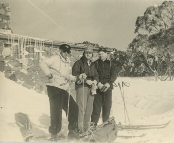
Photograph - Bogong Trip 1951- At Cleve Cole Lodge
MEYER COLLECTION - FALLS CREEK PHOTOS In 1947 a determined group of like-minded State Electricity Commission (SEC) staff including Ray Meyer, the chief surveyor of the Kiewa Hydro-Electric Scheme, had a common interest that revolved around the skiing potential of the snow-covered high plains which included what is now the resort of Falls Creek. The six SEC employees, Toni St Elmo, Ray Meyer, Jack Minogue, Lloyd Dunn, Adrian Ruffenacht and Dave Gibson (together with their families) banded together to secretly build a 'hut' that was the first ski lodge at Falls Creek. Using a road built in 1930s to gain access to Falls Creek, their hut project was carried out in secret as efforts by other skiers were blocked by H.H.C. Williams – the engineer in charge of the Hydro Scheme. In 1946 Ray Meyer made a trip to the Lands Office in Melbourne. He came away with a 99-year lease on three acres that was ideally suited for a hut designed by Lloyd Dunn. Adrian Ruffenacht (Design Engineer for the KHS) had suggested where the group should build because of easy access to a spring for water. Much of the building material required was scavenged from derelict huts on the high plains. Due to the need for secrecy, the determined group worked on the hut in the evenings and weekends to avoid detection. During the building period the group had met at Echidna Rock (now known as Eagle Rock) where Skippy St Elmo announced, "This is my favourite ‘Skyline’.” And so the first lodge in the area at Falls Creek Ski Resort came into existence. With the development of the International Poma in the 1970s, the Skyline Lodge, which was sited between the ski-lift’s pole one and pole two, was demolished. However, the legacy of Ray Meyer, Toni St Elmo, Jack Minogue, Lloyd Dunn, Adrian Ruffenacht and Dave Gibson and Skyline lives on in the vibrant atmosphere of Falls Creek Resort. The MEYER COLLECTION documents developments on the Kiewa Hydro Scheme and their life at Falls Creek from the mid 1930s to 1960s.This image is significant because it depicts aspects of the life of a pioneering family of Falls Creek and the founders of "Skyline", the first lodge at Falls Creek.Black and White Images of visitors at Cleve Cole Lodge. Photo 1. L to R:- Ray Meyer, H. Gibbs and Wal Johnson. Photo 2. Ray Meyer and Wal Johnson having photo taken. CLEVE COLE HUT was built in 1937 for the Ski Club of Victoria, to commemorate pioneer skier, Cleve Cole, who died on a disastrous ski trip across the high In August 1936 three men, Cleve Cole, Mick Hull, and Howard Michell, skied from Mount Hotham across the Bogong High Plains to Mount. On reaching the mountain they became trapped for four days on the summit ridge by appalling weather conditions. For three days they followed the Big River through rough country before deciding that Howard should continue alone to find help, leaving Mick to care for Cleve who was barely able to continue. Three days later a search party, raised after Howard had reached Glen Valley, found Cleve and Mick. Within two days the group arrived at Glen Valley where, tragically, Cleve Cole died later that night. In memory of Cleve’s life and his pioneering work in the Victorian alpine country it was decided to build a refuge hut on the mountain. It is called the Cleve Cole Memorial Hut.falls creek, bogong high plains, cleve cole hut -
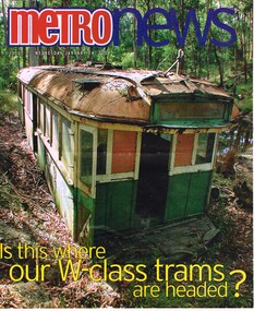 Melbourne Tram Museum
Newspaper, Metro News, Metro News - is this where our W class trams are headed?, 1984 to 2001
Set of five newspaper cuttings (or group of cuttings) regarding trams sold by the MMTB and their relocation. .1 - Community Valley News "Huge tram sure to stop traffic; well that's the idea!", 16/4/2002 - W6 968 being relocated to the Essendon Traffic School - see image i9. .2 - Cover and pages 6 & 7 of Metro News24/1/2001 - about the sale of W class trams. Cover photo has a tram at Dales Creek, story by Ingrid Svendsen about the storage of trams at Newport, reuse. Quotes Dr Mees, Roberto D' Andrea, Peter Batchelor and Geoff Leigh. .3 - Free Press - 22/2/1984 - "Last Stop Cockatoo" - W2 611 to Cockatoo Primary School. .4 - Diamond Valley News, 13/3/1984 about the sale of W2 640 to Mrs Fabian Broekan to the Eltham area and the objection of the Eltham council. .5 - The Sun - 24/8/1987 - "Aboard the tram home" about the former trams at Ferny Creek. Two centre pages. See also Reg Items about these tramcars. .6 - The Phillip Motorway - 19/8/1993 - about W2 284, owned by Evan Bekiaris which was built by Holdens in SA.trams, tramways, sale of trams, mmtb, newport workshops, preserved trams, ferny creek, tramcars, pmtt, melbourne, houses, essendon, holden, tram 968, tram 611, tram 640, tram 284 -
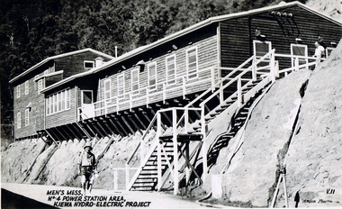 Kiewa Valley Historical Society
Postcard Circa 1950, Men's Mess No.4 Power Station, Kiewa Hydro-Electric Project
This postcard was produced in the 1950's for the tourist trade in the Kiewa Valley and Alpine region. It encompasses the period when the State of Victoria was pressured by the ever increasing demand by industry and its population for electricity supplies. Hydro electricity was seen as an untapped natural resource to quench this demand. The Victorian Alps and the rivers flowing into its valleys was ideal for the construction of the Kiewa Hydro Electricity Scheme. The late 1940's saw the development of this scheme and the changing of sections of alpine landscape is covered by this and other postcards/pictures (tourists, construction workers, and established rural populations). This period in time was before the established wildlife and forest/nature groups became political activist who changed legislative acts to protect the environment.Although this photo details the eating facilities of the construction workers at the power station it was not only a postcard for the people employed in the Hydro Scheme is was also provided to tourists visiting the area and thus used for promotional purposes.This rural region (Kiewa Valley/alpine plains) was at most only significant to a smaller group of winter sports, summer hikers/horse riders and rural farmers/graziers. The numbers of tourists and the increase in the local resident population was boosted by the construction of the Hydro Electricity Scheme. This influx to the regional population resulted in a corresponding diversity in services and brought about an environment that responded to a growing level of tourists and thereby permitting this industry to grow more rapidly than it would have naturally. This postcard details an attraction to the "cleaner" method of providing electricity. This postcard was purchased in 1950 by a surveyor at Landford's Gap. The men shown in this photograph would have been employed by the S.E.C. under the Kiewa Hydro-Electricity Scheme.This item is a scanned black and white photograph of a construction worker walking from stairs leading down from the men's mess building, in 1950. See 0480 (A) -(C), (E) - (F) for other photos of similar postcards"MEN'S MESS No.4 POWER STATION AREA, KIEWA HYDRO-ELECTRIC PROJECT" "ARGUS PHOTO V.IIkiewa valley tourism, victorian alps, alternate energy supplies, alpine population growth, secv -
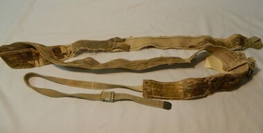 Kiewa Valley Historical Society
Seal Skins Ski Straps / Soles, mid 1900's
These seal skin straps and webbing were introduced into the Victorian Alps by European engineers, conducting survey work for the SEC Hydro scheme in the late 1930s. This period in time produced many immigrants from a war torn Europe with highly developed technical skills. Many of these immigrants provided articles that were well suited to the alpine regions of Australia, ones they used in their homelands. These were times when the home grown cultures of the Anglo Saxon heritage of the earlier settlers within the Kiewa Valley became interwoven with the various European cultures and this formed, what in later years became the beginning of the Australian multi-cultural society. The Kiewa Valley and its surrounding regions where the major rural areas which did not progress in a so typical Aussie "dinky-di", "she'll be right" fashion. The European influence was however not too strong, so as to obliterate the flavour of the home grown rural society.The major populated sections of the upper Kiewa Valley and the Alpine regions were accelerated by the SEC Hydro Development which brought into the slow growing rural regions a quasi multi ethnic society, however this was only noticeable up to the time when the final Power Station was commissioned in the 1960s. The slight variations to the typical Australian rural settlements of the time were in some food preparations, winter apparel such as these seal skin straps and soles and "langlauf" (cross-country skis). The sealskins were sewn so that their grain ran from front to back thereby allowing the skins to grip going up hill and glide going downhill.The gardens and varieties of flowering shrubs and trees where also more in line with traditional European "outdoor" settings. Seal skin sewn onto one side of a strap of webbing. There is a webbing loop on the front that slips over a small point at the front of the ski. There is a webbing strap attached to the back of the seal skin sole coming over the back of ski that clips metal fasteners onto a loop of webbing behind the ski boot. alpine sports, snow skis, winter clothing, mount bogong recreational activities, snow sports -
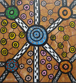 Federation University Art Collection
Painting, Ronald Edwards-Pepper, 2020
Ronald EDWARDS PEPPER Gunai Ronald Edwards Pepper is the grandson of Dulcie (Dolly) Mullet and Watson Pepper, Ronald’s family moved to Morwell in the 1960s from Lake Tyers Mission. He graduated from Federation University with a Bachelor of Visual and Media Arts in 2017, and has completed several commissions and participated in numerous exhibitions, in Australia and overseas. Artist Ronald Edwards-Pepper is keen to express himself through painting and telling stories of his Gunai/Kurnai ancestors. "My nanna and her stories have been part of my life, and who I have become today, and this influences my artworks. My grand-parents are Dolly Mullet & Watson Pepper. They came from Lake Tyers Mission and moved to Morwell in the 1960s with their mob of kids. Now this is the family home." EDUCATION: 2013-2017 - Bachelor of Visual & Media Arts/Federation University. 2010 - Trainee Mentor in Education (Latrobe Regional Gallery, Morwell) 2008 - Certificate III in Aboriginal Torres Strait Islander in Languages 2007 - Traineeships, Young Ambassador at the Latrobe Regional Gallery, Morwell 2006 - Completed & Graduated - Awarded 'Student of the Year’ 2005 - Certificate IV ATSI Cultural Arts, TAFE Mid-valley Campus Gippsland 2003 - Certificate 4 in Aboriginal and Torres Strait lslander Art & Design, TAFE Mid-valley Campus, Gippsland 2002 - Certificate 3 in Aboriginal and Torres Strait Islander Art & Design, TAFE Mid-valley Campus, Gippsland AboriginalSigned verso "R.Edwards"ronald edwards, aboriginal, gunai kurnai