Showing 4552 items matching "historical maps"
-
 Kew Historical Society Inc
Book, Frederick Howard, Kent Hughes: a biography of Colonel The Hon. Sir Wilfred Kent Hughes, 1972
Limited edition of 500 copies. Available from Ramsay, Ware Publishing Pty Ltd, 552 Victoria Road, North Melbourne, Vic. 3051.South Melbourne : Macmillan for the Kent Hughes Memorial Committee, 1972 ix,255p. : plates ; 23cm. non-fictionLimited edition of 500 copies. Available from Ramsay, Ware Publishing Pty Ltd, 552 Victoria Road, North Melbourne, Vic. 3051.kent hughes w.s. (wilfrid selwyn) 1895-1970, australia -- politics 1927-1970, sir wilfrid selwyn kent- hughes 1895-1970, biographies -- australia -- politics and government -- 20th century -
Kew Historical Society Inc
Book, Kew Municipal Library, Kew Births 1849-1870, 1994
Kew births 1849-1870 : records extracted from the Victorian pioneers index under the district names of Kew, Cotham and Studley ParkKew, Vic. : Kew Library, 1994. 1 vol. ; 30cm.non-fictionKew births 1849-1870 : records extracted from the Victorian pioneers index under the district names of Kew, Cotham and Studley Parkbirths - deaths - marriages -- kew (vic.) 1849-1870 -
Kew Historical Society Inc
Book, Keith Cole, Letters from China 1893-1895: the story of the sister martyrs of Ku Cheng, 1988
Kew, Vic. : St. Hilary's Anglican Church, 1988 x, 136 p. : ill., map, ports. ; 21 cm. non-fictioneleanor saunders 1871-1895, elizabeth saunders 1873-1895, st hilary's anglican church -- kew -- (vic.), missionaries -- china -- biography -
Kew Historical Society Inc
Book, McPhee Gribble, Living Places: twenty houses, 1987
Photographic project commissioned by The State Library of Victoria. "Two hundred of the four hundred photographs taken for the project are to be found at the State Library of Victoria ..."--Introd., p. 6.Fitzroy, Vic. : McPhee Gribble/Penguin, 1987 218 p. : ill., plans ; 21 x 25 cm. non-fictionPhotographic project commissioned by The State Library of Victoria. "Two hundred of the four hundred photographs taken for the project are to be found at the State Library of Victoria ..."--Introd., p. 6.housing -- australia, dwellings -- australia -- social aspects -
Kew Historical Society Inc
Book, Brian Carroll, Melbourne: an illustrated history, 1972
Melbourne : Lansdowne, 1972 128 p. : ill., col. plates ; 29 cm. melbourne 1802-1970 -- illustrations, melbourne (vic.) -- history -- 1802-1900 -- pictorial works -
Kew Historical Society Inc
Book, Brian Carroll, Melbourne churches & schools sketchbook, 1973
Adelaide : Rigby, 1973 62p. : ill. ; 23cm.non-fictionbuildings of historical importance -- churches --melbourne, buildings of historical importance -- schools -- melbourne, schools -- victoria -- melbourne, historic buildings -- victoria -- melbourne, melbourne (vic.) -- church buildings -
Kew Historical Society Inc
Book, City of Boroondara, 15 to 21: the stuff that surrounds us, 2001
Fifteen to twenty-one, the stuff that surrounds us Millennium photographic project : 15 to 21, the stuff that surrounds usCamberwell, Vic. : City of Boroondara, 2001 1 v. (unpaged) : ill. ; 22 x 26 cm non-fictionFifteen to twenty-one, the stuff that surrounds us Millennium photographic project : 15 to 21, the stuff that surrounds usphotography -- artistic -- victoria -- boroondara -
 Glen Eira City Council History and Heritage Collection
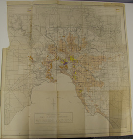
Map - Map, zoning, Metropolitan Town Planning Commission, "DISTRIBUTION AND USE OF EXISTING PROPERTY. MAP NO. 6.", 1929
The map titled: “Distribution and use of Existing property map No. 6” (Metropolitan Town Planning Commission Melbourne and Suburbs) is of historical significance. It is listed on page 168 of Chapter 4 the Zoning section of the "Plan of General Development Melbourne Report of the Metropolitan Town Planning Commission 1929" - Melbourne's first strategic plan. Map No. 6 is mentioned throughout Chapter 4 of the 1929 Report. It states on page 156 that this Map was created to graphically illustrate the data collected by the Planning Commission. The Map illustrates the general distribution of uses of existing property throughout the metropolitan area. The coloured sections show the areas which were developed or were in the process of development in 1929. The colours indicate the distribution of uses in the developed areas. The pink coloured areas, which include Caulfield, were almost completely residential.1929, metropolitan town planning commission, melbourne, suburbs -
Surrey Hills Historical Society Collection
Map, Contour map of Surrey Hills showing potential sites for the Telecom Tower
The PMG / Telecom / Telstra tower was built in 1961-1963 as a relay station to support television and radio links between city and regional broadcasting stations. The tower itself was 45 m in height with a 2 storey building for equipment and staff surrounded by garden. From the beginning it was opposed by local residents. The location is said to be the second highest site in Melbourne, sometimes described as Delaney's Hill.Two A3 photocopied sheets of a map showing part of Surrey Hills, roughly between Windsor Crescent and Belmont Street (north / south) and Standard Avenue and Balmoral Crescent (east / west). The map shows contour lines and house sites, 16 of which are numbered. One sheet has been inscribed in top RH corner with notes regarding the significance of the numbers."Contour map of potential sites / for the telecommunications tower which / was eventually sited at 2. / Jock Campbell OBE was our neighbour / at 4 Theodore St when we moved into / the area in 1984. He was responsible in his / job at the PMG in deciding on the /site of the tower - Note site 5 was / behind his (& our) house. / Jack ended his career as Deputy Director / of the PMG. He sat on international committees / after WW2 to decide the split of the electronic / spectrum for radio, TV etc. / His group developed a "mobile phone" using / fixed towers but the phone was a truck full of gear."contour map, telecom tower, maps, jock campbell, john duncan campbell -
Stawell Historical Society Inc
Archive, Amalgamated Scotchman’s Company Cyanide Works Records. 1899, 1898 - 1901
Assorted Papers forms, maps etcstawell, mining -
Stawell Historical Society Inc
Archive, Great Western Cemetery Records. Names of Burials Recorded, 1860
Death Certificates Inquests Register MapPhotocopied Lots of Burials at Great Western cemetery -
 Stawell Historical Society Inc
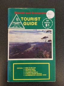
Book, Stawell & Grampians Tourist Council, Stawell & Grampians Visitor Guide & Directory 1979, 1979
Tourist Guide to Stawell and the GrampiansBlue cover with red, yellow & blue print. Picture of the Grampians in center of cover.In Red Print Stawell and Grampians. In Yellow Print Visitor Guide and Directory. In Blue Print 4th Edition Souvenir Edition. In White Inset "Containing Offical Walking Maps. Bottom Right in Yellow Print " Issued by the Stawell and Grampians Tourist and Promotion Advisory Council. In two white circle with white and Red print the Price in Red "Recommended $1.00 Price" Bottom Right at 45 degrees in blue print Concession Coupons Inside.stawell tourism -
 Stawell Historical Society Inc
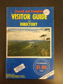
Book, Stawell & Grampians Tourist Council, Stawell & Grampians Visitor Guide & Directory 1981, 1981
Tourist Guide to Stawell and The GrampiansGreen paper cover with Red, Yellow & White Print. Centre of page is a colour photo of the Grampians. Red Test. "Stawell and Grampians" inside white triangle "Stawell & Grampians Promotion". Yellow Print Tourist Guide" Inside a white segmented circle, white Print "5th Editon $1" Inside Yellow outlined rectangle with yellow Print. "Contains: WHAT TO SEE & DO REFERENCE MAPS NOTES ON 5 TOURS 28 GRAMPIANS WALKS 9 SPECIAL FEATURE ATICLES ACOMMODATION & BUSINESS GUIDEstawell tourism -
Stawell Historical Society Inc
Map, Gampola, County of Borung, 1957
Gampola, County of Borungstawell -
Stawell Historical Society Inc
Map, Bellaura, County of Borung, 1880
Bellaura, County of Borungstawell -
Stawell Historical Society Inc
Map, Bellaura, County of Borung, 1924
Bellaura, County of Borungstawell -
Stawell Historical Society Inc
Map, Bellellen, County of Borung, 1952
Bellellen, County of Borungstawell -
Stawell Historical Society Inc
Map, Bolangum, County of Kara Kara, 1957
Bolangum, County of Kara Karastawell -
Stawell Historical Society Inc
Map, Boroka, County of Borung, 1958
Boroka, County of Borung stawell -
Stawell Historical Society Inc
Map, Bulgana, Counties of Borung & Ripon, 1959
Bulgana, Counties of Borung & Riponstawell -
Stawell Historical Society Inc
Map, Callawadda, Counties of Borung & Kara Kara, 1959
Callawadda, Counties of Borung & Kara Karastawell -
Stawell Historical Society Inc
Map, Concongella, County of Borung, 1929
Concongella, County of Borungstawell -
Stawell Historical Society Inc
Map, Physical description Concongella South, Counties of Borung & Ripon, 1957
Concongella South, Counties of Borung & Riponstawell -
Stawell Historical Society Inc
Map, Gampola, County of Borung, 1957
Gampola, County of Borungstawell -
Stawell Historical Society Inc
Map, Glenorchy, County of Borung, 1956
Glenorchy, County of Borungstawell -
Stawell Historical Society Inc
Map, Agricultural Area of Lake Wilson, Parishes of Bellaura & Bellellen, 1865
Agricultural Area of Lake Wilson, Parishes of Bellaura & Bellellenstawell -
Stawell Historical Society Inc
Map, Glynwylln, Counties of Borung & Kara Kara, 1929
Glynwylln, Counties of Borung & Kara Karastawell -
Stawell Historical Society Inc
Map, Great Western, Parish of Concongella, County of Borung, 1958
Great Western, Parish of Concongella, County of Borungstawell -
Stawell Historical Society Inc
Map, Illawarra, County of Borung, 1882
Illawarra, County of Borungstawell -
Stawell Historical Society Inc
Map, Illawarra, County of Borung, 1955
Illawarra, County of Borungstawell