Showing 10832 items
matching maps
-
 Melbourne Tram Museum
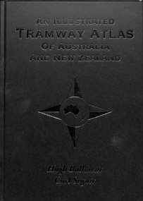
Book, Hugh Ballment, Carl Segnit, "An Illustrated Tramway Atlas of Australia and New Zealand", 2018
... Maps ...Book - hard cover, 9 sewn sections, full paper bound front covers, 120 pages, gloss paper printed in full colour titled "An Illustrated Tramway Atlas of Australia and New Zealand" with a table of contents by Hugh Ballment and Carl Segnit published by Transit Australia, 2018. Has a preface and acknowledgements, lists 23 Australian and 9 New Zealand cities that had public street tramway systems. Gives maps of the Tramway Museums at the time, trams on public displays and tramway museums that have closed. Includes cable trams, some horse trams, VR, Doncaster, Commonwealth Engineering test facility at Dandenong and depot layouts.trams, tramways, atlas, australian tramways, maps, commonwealth engineering, melbourne, vr, cable trams, depots -
 Bendigo Military Museum
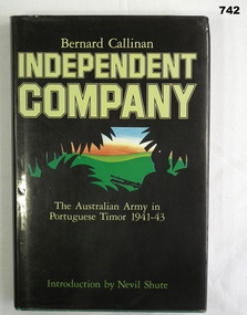
Book, William Heinemann, Independent Company The Australian Army in Portuguese Timor 1941-43, 1984
Documents the role of the Australian Army in Portuguese Timor from 1941-43. Introduction written by Nevil Shute.235 page green hardcover book with gold title on spine. Dust cover is black with silhouette of soldier and leaves against green hills and orange and blue skyline. Pages edges are cut, inside front cover has map of SE Asia and inside back cover has map of Timor. Includes maps and B&W illustrations.Printed sticker inside front cover "From Bishop Daly's collection 2004" On title page "+ N D Daly, Bendigo. January 1986"books, military history, timor -
 Federation University Historical Collection
Booklet, Northern Territory ... The Tanami Gold Country with Plans, 1909, 1909
Pink foolscap report of 12 pages, includes geological map from Pine Creel to Sturt's Creek by H.Y. L. brown; geological map between Mucka and Gordon Downs Station and Tanami by W.R. Murray; geological map of Tanami and surrounding country by W.R. Murray, and Plan of Lawne's Gold Prospecting Claim at Tanami by W.R. Murray pine creek, sturt's creek, tanami, northern territory, tanami gold country -
 Bendigo Historical Society Inc.
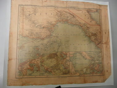
Map - STRAUCH COLLECTION: MAP BRITISCH PAPUA
Copy of original heritage map of ''Britisch Papua'' (N.G.) detailed & mapped by German (marine navigator) 'Gezeichnet von C.Barich & produced in the 'Langhans Deutscher Kolontal Atlas, Feb. 1893. Presented to German Society, 30.5.2008 by Mr P.Thwaites, Plans & Projects Officer (Digo 2008) Plus Society's laminated work copy of same map.map -
 Bendigo Historical Society Inc.
Map - BENDIGO GOLD FIELD GEOLOGICAL MAP
Geological map of the Bendigo Gold Field showing stratigraphical zones. Map in two sections, colour coded showing anticlines, synclines, shafts, fault lines, fossils. Signed by H. Herman. This map forms part of the Geological Survey of Victoria, Structure of Bendigo Goldfield report, No. 47, 1923. H.Herman, late Director of Geological Survey.Geological Survey Victoriabendigo, gold mining, geological map -
 Kew Historical Society Inc
Map, MMBW, MMBW Plan No.64 Kew & Heidelberg, 1900-1910
The Melbourne and Metropolitan Board of Works (MMBW) was established by an act of the Victorian Parliament in 1890 to prepare for and to implement a sewerage and water reticulation system across what was then inner Melbourne, its surrounding and middle distance suburbs, including Kew. The MMBW was disbanded in 1991.The map collection of the Kew Historical Society has at its core the historic maps assembled and originally stored in the City Engineer's Department of the City of Kew. These include maps in a number of scales. The vast majority of maps were produced by the MMBW in the first two decades of the twentieth century, and are solid working maps, backed by linen for durability. These maps are historically significant to Kew, the City of Boroondara and to the history of the development of state utilities in Victoria. A number of the Kew maps have additional details added by former municipal officers, including the levels reached by various floods. As these were working documents, information was added to them long after the period of their initial production and distribution.Early map of part of the Borough of Kew, created in the first decade of the twentieth century, at a scale 160 ft to 1 inch. The map covers what was then the northern most part of Kew, bordered on its north and west by the Yarra River, in the East by Connor's Creek and by the Asylum in the south. The map shows the extent of urban development by that time, prominent institutions and the outlines of built structures in the municipality. Contour lines and historic flood levels were added in ink to the map at a later stage.MELBOURNE AND METROPOLITAN BOARD OF WORKS / PLAN NO. 64 / KEW & HEIDELBERGmelbourne & metropolitan board of works, mmbw maps, mmbw plans, borough of kew, cartography -
 Kew Historical Society Inc
Map, MMBW, MMBW Plan No.65 Kew & Heidelberg, 1900-1910
The Melbourne and Metropolitan Board of Works (MMBW) was established by an act of the Victorian Parliament in 1890 to prepare for and to implement a sewerage and water reticulation system across what was then inner Melbourne, its surrounding and middle distance suburbs, including Kew. The MMBW was disbanded in 1991.The map collection of the Kew Historical Society has at its core the historic maps assembled and originally stored in the City Engineer's Department of the City of Kew. These include maps in a number of scales. The vast majority of maps were produced by the MMBW in the first two decades of the twentieth century, and are solid working maps, backed by linen for durability. These maps are historically significant to Kew, the City of Boroondara and to the history of the development of state utilities in Victoria. A number of the Kew maps have additional details added by former municipal officers, including the levels reached by various floods. As these were working documents, information was added to them long after the period of their initial production and distribution.Early map of part of the Borough of Kew, created in the first decade of the twentieth century, at a scale 160 ft to 1 inch. The map covers what was then the south central part of Kew, bordered on its north by Malmsbury Street, in the west by Florence Avenue, in the south by Barkers Road, and in the east by Princess Street. The map shows the extent of urban development by that time, prominent institutions and the outlines of built structures in the municipality. Contour lines were added in ink to the map at a later stage.MELBOURNE AND METROPOLITAN BOARD OF WORKS / PLAN NO. 65 / KEW & HEIDELBERGmelbourne & metropolitan board of works, mmbw maps, mmbw plans, borough of kew, cartography -
 Kew Historical Society Inc
Map, MMBW, MMBW Plan No.66 Kew, 1900-1910
The Melbourne and Metropolitan Board of Works (MMBW) was established by an act of the Victorian Parliament in 1890 to prepare for and to implement a sewerage and water reticulation system across what was then inner Melbourne, its surrounding and middle distance suburbs, including Kew. The MMBW was disbanded in 1991.The map collection of the Kew Historical Society has at its core the historic maps assembled and originally stored in the City Engineer's Department of the City of Kew. These include maps in a number of scales. The vast majority of maps were produced by the MMBW in the first two decades of the twentieth century, and are solid working maps, backed by linen for durability. These maps are historically significant to Kew, the City of Boroondara and to the history of the development of state utilities in Victoria. A number of the Kew maps have additional details added by former municipal officers, including the levels reached by various floods. As these were working documents, information was added to them long after the period of their initial production and distribution.Early map of part of the Borough of Kew, created in the first decade of the twentieth century, at a scale 160 ft to 1 inch. The map covers what was then the south eastern part of Kew, bordered on its north by Adeney Avenue, in the west by Sackville Street, in the south by Barkers Road, and in the east by Burke Road. The map shows the extent of urban development by that time, prominent institutions and the outlines of built structures in the municipality. Contour lines were added in ink to the map at a later stage.MELBOURNE AND METROPOLITAN BOARD OF WORKS / PLAN NO. 66 / KEW melbourne & metropolitan board of works, mmbw maps, mmbw plans, borough of kew, cartography -
 Lara RSL Sub Branch
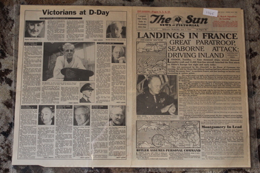
Newspaper - Herald Sun 50th Anniv. Re Print of a Newspaper dated 6/6/1994 Of D-Day 7/6/1944
Herald Sun 50th Anniv. Newspaper dated 6/6/1994 Of D-Day 7/6/1944Newspaper - D-Day Invasion 7/6/1944Herald Sun 50th Anniv. Newspaper dated 6/6/1994 Of D-Day 7/6/1944Landings In France - Hitler Assumes Personal Command - Map The Normandy Invasion D-Day 6/6/1944landings in france - hitler assumes personal command - map the normandy invasion d-day 6/6/1944 -
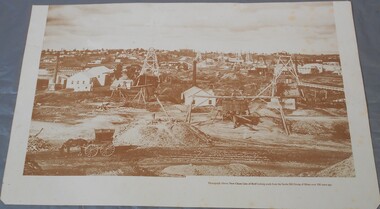 Bendigo Historical Society Inc.
Photograph - Photograph of New Chum Line of Reef
BHS CollectionSepia coloured print of a photograph of the New Chum Line of Reef looking south from the Snobs Hill group of mines. The photo shows several poppet heads and chimneys, bridges and houses. New Chum Line of Reef. includes Victoria Hill possibly the richest spot on the field.On the back a drawing of a poppet head with the words: Bendigo gold project. A small map of Victoria is also printed on the back. bendigo mines, new chum line of reef, mining -
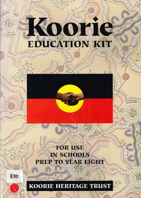 Victorian Aboriginal Corporation for Languages
Kit, Koorie education kit, 1995
Koorie cultural heritage is introduced in lesson form. For use in schools Prep to Year Eightmaps, b&w photographs, b&w illustrations, cartoons, colour photographs, A4-sized information cardskoorie culture and education, primary school education, koorie history -
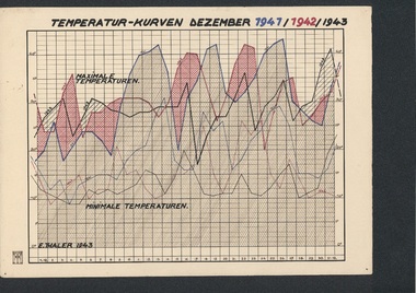 Tatura Irrigation & Wartime Camps Museum
Folio, Loveday & Camp 1 Temperature & Wind records, 1942-45
... maps ...Records taken and graphed while in internment at Loveday and Tatura. Sketches and story were done in Camp 3, TaturaBlue plastic folder and sleeves containing 10 graphs, and nineteen coloured pen and ink and colour sketches and story of young children in Camp 3ww2 camp 3, loveday, documents, maps -
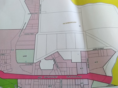 Peterborough History Group
Map - Peterborough Planning Map
... maps ...Planning information as at 2012Showing the changing face of PeterboroughA3 size printed copies (2) of planning, environmental and other overlays for the town of Peterborough in 2012peterborough, town planning, maps, moyne shire zoning map -
Whitehorse Historical Society Inc.
Map, Dandenong Ranges Area, 1956
... Maps ...Sheet 1. Parts of Parishes: Nunawading, Warrandyte and Ringwood. Scale: 10 chains : 1 inch. Contour intervals marked and locations of buildings.Sheet 1. Parts of Parishes: Nunawading, Warrandyte and Ringwood. Scale: 10 chains : 1 inch. Contour intervals marked and locations of buildings. Compiled from aerial photographs and cadastral survey information.Sheet 1. Parts of Parishes: Nunawading, Warrandyte and Ringwood. Scale: 10 chains : 1 inch. Contour intervals marked and locations of buildings. maps, ringwood, mitcham, warrandyte -
Whitehorse Historical Society Inc.
Map, Dandenong Ranges Area, 1955
... Maps ...Sheet 13. Parts of Parishes: Nunawading, Mulgrave and Scoresby.Sheet 13. Parts of Parishes: Nunawading, Mulgrave and Scoresby. Includes area of Vermont South marked as proposed Township of Norwich. Scale 10 chains : 1 inch. Contours marked.Sheet 13. Parts of Parishes: Nunawading, Mulgrave and Scoresby. maps, vermont south, wantirna, dandenong creek -
Whitehorse Historical Society Inc.
Book, The Herald Road Guide, 1930's
... Maps ...A Road Guide Book of Victoria and routes to Sydney, Brisbane, Canberra, Adelaide and Alice Springs.A Road Guide Book of Victoria and routes to Sydney, Brisbane, Canberra, Adelaide and Alice Springs.A Road Guide Book of Victoria and routes to Sydney, Brisbane, Canberra, Adelaide and Alice Springs.maps, tourism, australia, victoria -
Whitehorse Historical Society Inc.
Map, Mitcham Riding, n.d
... maps ...Shire of Nunawading: Mitcham Riding [n.d.] (between Springvale and Mitcham Roads) (Shows electric light mains. MMBW reserves, railway line.)mitcham, maps, tunstall, forest hill -
Whitehorse Historical Society Inc.
Map, Nunawading, Ringwood and Scoresby, 16/02/1858 (original)
... maps ...Plan of country lands in the Parishes of Nunawading, Ringwood and Scoresby in the Counties of Bourke and Mornington. Lithographed at the Public Lands Office, Melbourne, 16 February 1858. Inset: Pound Reserve, Nunawading.nunawading, ringwood, scoresby, maps -
![Parish of Nunawading, County of Bourke showing land acquired under Closer Settlement Acts [C 1887]](/media/collectors/56f368632162f118acbff12e/items/60d923316e5f99545134f182/item-media/6147b12a4806c7ae686c24e4/item-fit-380x285.jpg) Whitehorse Historical Society Inc.
Whitehorse Historical Society Inc.Map, Parish of Nunawading, ca 1887
... maps ...Parish of Nunawading, County of Bourke showing land acquired under Closer Settlement Acts [C 1887]Parish of Nunawading, County of Bourke showing land acquired under Closer Settlement Acts [C 1887] 1947 reprint.Parish of Nunawading, County of Bourke showing land acquired under Closer Settlement Acts [C 1887] parish of nunawading, box hill, maps, land settlement -
Glenelg Shire Council Cultural Collection
Souvenir - Plate - State of Victoria, c. 1984
White, boxed, fine china Westminster plate, State of Victoria, in green with black place names, floral emblem (pink heath) above state. Gold rim. Plate size is 19cm diameterFront: 'State of VICTORIA 150TH ANNIVERSARY' - blue lettering, above map 1984-5 GROWING TOGEHTER' - blue lettering beneath map. Back: Time line of Victoria's first 150 years - in black print. 150th logo Westminster Australia. Makers mark -
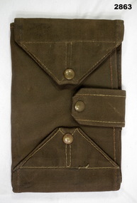 Bendigo Military Museum
Equipment - MAP CASE, Army Issue, Post WW2 possibly
Map Case, khaki canvas outer, tri-fold with clear perspex sections for securing map inside. Fastens with two canvas flaps & brass press studs & a canvas strap. Small pocket on outside. military equipment, containers, map, passchendaele barracks trust -
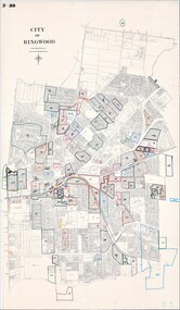 Ringwood and District Historical Society
Map, City of Ringwood - Rateable Properties Layout - c.1966
A0-size (approx) map of named streets, lot-numbered properties and locality features within City of Ringwood boundary. Coloured outlines of subsequent subdivisions. Seperate enlargement showing northern half of map.Scale: 8 chains to 1 inch. -
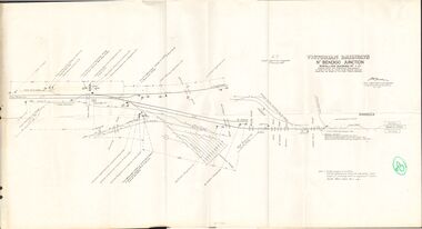 Bendigo Historical Society Inc.
Document - BADHAM COLLECTION: VICTORIAN RAILWAYS MAP - NTH BENDIGO JUNCTION SIGNALLING DIAGRAM NO 4'80
Victorian railways map: Nth Bendigo junction signalling diagram no 480 showing signal and interlocking arrangements. Large paper map, A F chief electrical engineer 9.1.1980. Black ink diagram and writing.document, memo, railway, nth bendigo junction signalling diagram no 4'80 -
Bendigo Historical Society Inc.
Map - CAMPBELL COLLECTION: BENDIGO & DISTRICT MAPS, 2-2-29
Map. Wellsford, Parishes of Wellsford and Axedale. Scale 20 chains to 1 inch. Total area 4994 acres. Prepared in W.P.B. from A. and P. Plans by W.J.G. (number 377 in map cupboard 1)W.J.Galbraithmap, bendigo, country lands -
 Bendigo Historical Society Inc.
Document - CENTRAL DEBORAH GOLD MINE : GOLDEN SQUARE MINE SITES
Map showing mines in the Golden Square, Diamond Hill area. Roads include Diamond Hill Road, Burns Street, Woodward Road, Belle Vue Road, Houston Street. Latitude and Longitude on map.bendigo, mining, golden square mine sites -
Bendigo Historical Society Inc.
Map - WELLSFORD : COUNTY OF BENDIGO, 6-10-03
Map. Wellsford, County of Bendigo, Bagshot, Ellesmere, Axedale, Hunty, Sandhurst, Strathfieldsaye. Photo-Lithograph ed at the Department of Lands and Survey Melbourne. 6-10-03. (number 21 in map cupboard 1)T.E. McGearsonmap, bendigo, wellsford -
Bendigo Historical Society Inc.
Map - LOCAL AREA PLANS, See above
Map: Compilation of maps: Village of Redcastle dated april 14 1861, Township of Yarraberb dated 14 July 1874, Hamlet of White Hills dated December 27 1872, Road survey of Toolleenmap, parish plan, redcastle, yarraberb, white hills, toolleen -
Bendigo Historical Society Inc.
Map - SUBDIVISION OF STERNBERG'S ESTATE, 24/06/1920
Map: Subdivision of Sternberg's Estate, Crown Allotments 75, 76, 76A, 76B and 77, Parish of Rochester West, County of Bendigo. Parish plan Canvas backed ( number 133 in Map Cupboard 1)map, bendigo, rural, sternberg's, crown allotments 75, 76, 76a, 76b, 77, rochester west, county of bendigo -
Tatura Irrigation & Wartime Camps Museum
Tray, 1940's
Made by internee at Camp 3, TaturaSuperb serving tray - heavy border. Handle end on left : map of Australia and Kangaroo. Handle end of right : map of Australia and Kookaburra Gum leaves (6) on stem marked on Centre Camp| Taturatray, kangaroo, kookaburra, lorence a, gratz a, camp 3, tatura, ww2 camp 3, handcrafts, woodcarving -
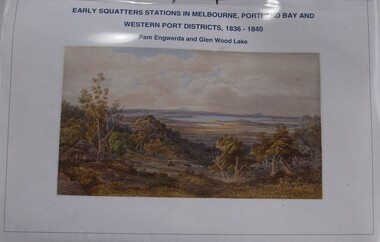 Buninyong Visitor Information Centre
Booklet - Index to Map, et al, Early Squatters' Stations in Melbourne, Portland Bay and Western Port Districts, 1836-1840, 2016
Photocopied copy of an index.Horizontally bound A4 typed listing with coloured illustration on the front page and a clear plastic cover sheet.non-fictionPhotocopied copy of an index.settlers, farming, pastoralism