Showing 10391 items
matching plan
-
 Stawell Historical Society Inc
Book - Grampians National Park - Report, Grampian National Park: Inventory of Resources and Uses, 1984
To be read with Grampians National Park Draft Management PlanSoft Cover, Blue. Pen lined drawing - part of Grampians. Black tape over spineLogos of National parks Services and Australian National Parks and Wildlife Service. -
 Whitehorse Historical Society Inc.
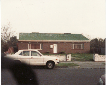
Photograph, Mitcham Angling Club Headquarters, 13/06/1986 12:00:00 AM
Plans for this building were drawn by Ray Meagher, c1943.2 Coloured photos of Mitcham Angling Club Headquarters, West side Brittania Street, Mitcham. Originally located on Northern side of Guide Hall in small galvanised iron shed -(see NP1064) - now relocated in Brunswick Roadmitcham angling club, angler's club, meagher, ray -
 Whitehorse Historical Society Inc.
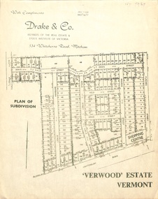
Document, Verwood Estate, Vermont
A subdivision plan of 'Verwood Estate', Vermontnon-fictionA subdivision plan of 'Verwood Estate', Vermontverwood estate vermont, drake real estate, drake co -
Moorabbin Air Museum
Booklet (Item) - International Civil Aviation Organization Airport Planning Manuals, Airport Planning Manual
Contains information about master planning and land use -
Glen Eira Historical Society
Letter - Gardenvale Road, 78, Gardenvale
This file contains six items. Five items of typed correspondence concerning application to build four double-storey dwellings at 78 Gardenvale Road. Correspondence between City of Glen Eira and residents R.A. and P. Darke from 08/12/2008 to 20/03/2009, and Paul Siedle. Typed copy of resident Jonathon Breedon’s objections to the proposed plan. Copy of original plans for the dwellings dated 12/09/2008. Copy of amended plans for the four dwellings dated November 2008. Typed letter dated 20/03/2009 from Glen Eira Senior Town Planner to Richard and Peta Darke notifying of council’s decision of intention to grant a planning permit for the dwellings. Typed five page notice of decision to grant a planning permit for the four dwellings dated 20/03/09. Included is a one page description of the appeal process.gardenvale road, magnolia road, gardenvale, city of glen eira, city hall, glen eira road, hawthorn road, lloloma receptions, caulfield south, darke peta, darke richard, elster avenue, elsternwick, torres ron, kokkinos stella, glen eira city council, statutory planning department, breedon jonathon, lantana road, peter l. brown architects pty ltd., glen eira planning scheme, elsternwick library, bentleigh library, carnegie library, caulfield library, staniland grove, jasper road, shepparson avenue, bentleigh, carnegie, caulfield, siedle paul, townhouses, town planning, plans, aerial photographs, architectural drawings, architects, brick houses -
 Kiewa Valley Historical Society
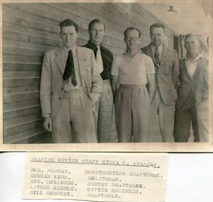
Set of 4 photographs of SECV Clerical staff, 1940 - 1941
The Kiewa Hydroelectric Scheme is the largest hydro-electric scheme in Victoria and the second largest in mainland Australia after the Snowy Mountains Scheme. The scheme is situated in the Australian Alps in north-eastern Victoria about 350 km from Melbourne and is wholly owned by AGL Energy. The scheme was originally constructed between 1938 and 1961 by the State Electricity Commission of Victoria although it was privatised in the 1990s. The scheme was originally developed solely for electricity generation, unlike the Snowy Mountains Scheme, which was also intended to direct water west of the Snowy Mountains for purposes of irrigation. From 1937 to 1944 the construction of dams at Pretty Valley, Rocky Valley and the Junction Dam were undertaken requiring large numbers of planning and support staff to see the projects successfully completed. Planning and support staff were the backbone of the successful completion of the Kiewa Valley Hydro Electric Scheme and contributed significantly to the development of the Kiewa Valley area. Many descendants of the men in the photographs still living and working in the local areaSet of 4 black and white photographs of SECV clerical staff – Circa 1940/1941Typed on note glued to back of each photo, Numbers handwritten in blue ink in top left hand corner 1. DRAWING OFFICE STAFF KIEWA C. 1940-41 Bob Morgan – Construction Draftsman; Duncan Kerr – Draftsman; Rob Hollands – Survey Draftsman; Arthur Keeble – Office Engineer; Bill Godfrey – Draftsman 2. CLERICAL OFFICE STAFF KIEWA Peter Harnetty – Clerical; Bert Connors – Clerical; John Martin – Stores Clerical; Ken Calder – Head Storekeeper; Bill black – Construction Records 3. CLERICAL OFFICE STAFF KIEWA Jack Norman, Herb Kendall, Jack Bray – Stores Clerical; Ken Calder – Head Storekeeper; Jim Swain, George Milner – Stores Clerical; Jim Gleeson – Storekeeper; John Martin – Stores Clerical 4. OFFICE STAFF KIEWA C. 1940 Don Faulkner – Cadet Engineer; Tas Davies – Survey Draftsman; Bob Morgan – Construction Darftsman; R.J. Martin, Arthur Keeble – Office Engineers; Rob Hollands – Survey Draftsman; Jack Wollard – Head Surveyor; Harry Wilson – Plan Officer. Printing Plans Handwritten in red ink on back of photo 4 – Refer Rob Hollands secv clerical staff -
 Warrnambool and District Historical Society Inc.
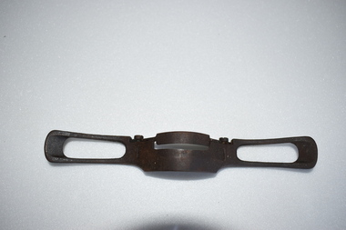
Metal Plane, Late 19th century
This item is one of several tools that are believed to have belonged to the Warrnambool carpenter and businessman, Henry Phillips. English-born Henry Phillips (1821-1896) came to Australia with his wife Elizabeth in 1849. They lived for some time in Port Fairy. In 1865 Henry formed a partnership with Christopher Beattie and established the Warrnambool undertaking business of Beattie and Phillips. This business continued on after the deaths of the founders and lasted until the year 2000. In Warrnambool Henry Phillips was involved in the management of the Mechanics Institute. This item is of interest as an example of a vintage tool and as a memento of the Warrnambool carpenter and businessman, Henry Phillips. This is a metal tool with a curved centre section and two hollow pieces at the ends acting as handles. The blade for planing is curved and the degree of the curving can be changed by the adjustment of two metal screws. vintage tools, henry phillips, warrnambool -
Glenelg Shire Council Cultural Collection
Pamphlet - Brochure, Steam Packet Inn, n.d
The Steam Packet Inn is the second oldest building in Portland. It was licensed to an ex convict from Van Diemens Land (Tasmania) in 1841. Later became a police barracks. It is a heritage listed buildingYellow card, tri-fold brochure, containing history of Steam Packet Inn, Bentinck St. Portland. Photo of steam Packet Inn on front of brochure, floor plans on the back.steam packet inn, bentinck street, portland -
Federation University Historical Collection
Book, Geologiocal Survey of Victoria No 4. The Ballarat East Goldfield, 1907, 1907
.1) 52 page fooslcap book with 41 plates and plans. Mines include News Zealand Trust, Lannberris No 1, etc. .2) Photographic image taken from the book ballarat east, ballarat east goldfield, mining, gregory, j.w. gregory, geological survey no. 4, llanberris -
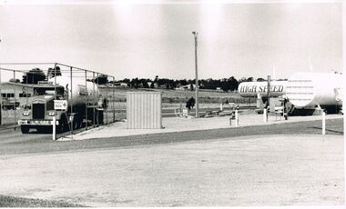 Bendigo Historical Society Inc.
Photograph - CASTLEMAINE GAS COMPANY COLLECTION: PHOTO GAS DEPOT
T.L.P.G. Plan. On Left hand side Brambles gas Truck. A small shed and on the left hand side to gas tanks. Several houses can be seen in background. Date Unknown.organisation, industry, gas and fuel -
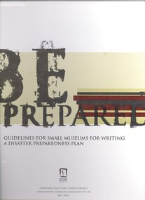 Bendigo Historical Society Inc.
Book - BE PREPARED, c2000
Be Prepared, Guidelines For Small Mueums For Writing A Disaster Prearedness Plan. Publisher: Heritage Collections Council. ISBN: 0 642 75097 1. Place of publication: Canberra. 112 pages.australia, disaster preperation for museums -
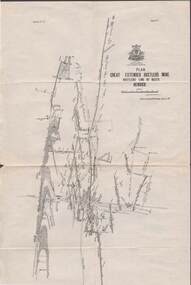 Bendigo Historical Society Inc.
Map - STRUGNELL COLLECTION: HUSTLER'S LINE OF REEFS, BENDIGO, September 1913
Map, Hustler's Line of Reefs, Great Extended Hustler's Mine Plan, Plate No. X1 (11). Bulletin No 33 Signed H.A.Whitelaw Underground survey Office Bendigo September 1913.Underground Survey Office, Bendigo.map, bendigo, great extended hustler's mine -
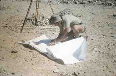 Bendigo Historical Society Inc.
Slide - RALPH BIRRELL COLLECTION: EIG SCHOOL, c1966
EIG School - Ralph Birrell Collection. - Construction of Latrobe Uni. C1966. Bendigo Institute of Technology, Engineering School, Applied Science. Surveyor studying the plans for La Trobe University.Kodakeducation, tertiary, latrobe university bendigo, eig school - ralph birrell collection. - construction of latrobe uni. c1966. bendigo institute of technology, engineering school, applied science. surveyor workman plans -
Port Melbourne Historical & Preservation Society
Audio - Radio Interviews, Dr Kim Dovey, Robert Peck, Greg Flynn re Sandridge City Development plan, 27 Nov 1991
Radio interviews with Dr Kim Dovey, Robert Peck, Greg Flynn, re the Sandridge City plan and the cleanup of the site. Recording 27.11.1991 and other dates, duration 30:48town planning - proposals shelved, dr kim dovey, robert peck, greg flynn -
Port Melbourne Historical & Preservation Society
Letter - Rezoning, MMBW, Melbourne and Metropolitan Board of Works, 23 Jul 1958
Melbourne and Metropolitan Board of Works (MMBW) letter regarding rezoning near corner of Crockford and Raglan Streets dated 23 July 1958 with hand drawn and coloured plan attached.town planning, mmbw, melbourne and metropolitan board of works -
Port Melbourne Historical & Preservation Society
Document - Tender, G T Judge, Erection of 80 buildings, Port Melbourne, G T Judge, 11 Sep 1923
Handwritten tender from G.T. Judge 1923, for the erection of 80 buildings in Port Melbourne in accordance with plans and specifications (refer other tenders, items 543, 549, 552 and 554)local government - city of port melbourne, built environment - domestic, built environment - public housing, g t judge -
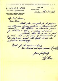 Bendigo Historical Society Inc.
Document - BILL ASHMAN COLLECTION: BUILDING QUOTE, 1957
Envelope addressed to Mr F.A.Stevenson Garage Hargreaves St Bendigo containing a quote and plan for a building from R.House & Sons Builders & Contractors Albion Street Bendigo dated 19.7.57.communication, postal, letters -
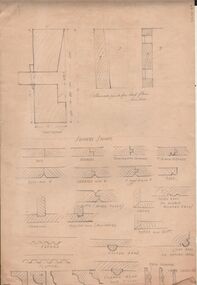 Bendigo Historical Society Inc.
Drawing - NORMAN PENROSE COLLECTION: WOOD WORKING JOINTS
Artwork. Norman Penrose collection: 3 pages of drawings depicting wood working joins. 1 page of miscellaneous drawings. Includes Plan of Box Frame for Double Hung Window.drawing, pencil, norman penrose collection, artwork, wood working joints, box frame for double hung window -
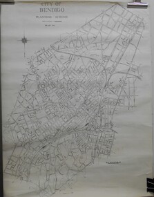 Bendigo Historical Society Inc.
Map - JACK FLYNN COLLECTION: BENDIGO, Revised 1/01/1961
Map: Bendigo city, it has City of Bendigo Planning Scheme as the title. Showing the city within the Municipal Boundaries, also has contour lines and the Major Gullies. Revised 1.1.1962.map, bendigo, city streets, bendigo planning scheme -
Bendigo Historical Society Inc.
Map - BENDIGO (PART), No date visible
Map: Portion of Bendigo parish plan, showing from Murphy St. East to Bob St and between rail line to old saleyards to the old Heathcote line Canvas backed.map, bendigo, city streets, bendig parish plan , bendigo city streets -
Clunes Museum
Document - CONSERVATION MANAGEMENT PLAN, RBA ARCHITECTS, CONSERVATION CONSULTANTS, NOVEMBER 2018
CLUNES FREE LENDING LIBRARY CONSERVATION MANAGEMENT PLAN, NOVEMBER 2018 INCLUDES HISTORY, ARCHITECTURAL DRAWINGS AND PHOTOGRAPHS CLEAR FRONT COVER, BLACK BACK COVER, SPIRAL BOUNDconservation management plan, rba architects, free lending library -
Victorian Aboriginal Corporation for Languages
Conference proceedings, Joe Blythe, Maintaining the links : language, identity and the land : proceedings of the Seventh FEL Conference, Broome, Western Australia, 22-24 September 2003, 2003
Major headings: Languages & Land claims; Toponymy & Topography; Planning for the future; Language, identity & the environment; Language & Identity: Home & Away; Language revitalisation: Maintenance; Documenting ENdangered LanguagesMaps, graphs, word listsland claims, east kimberley, ecotourism, nsw, borroloola, gurr-goni, maningrida -
Lakes Entrance Regional Historical Society (operating as Lakes Entrance History Centre & Museum)
Book, Landsmith Pty Ltd, Foreshore Development, 1996
This plan was formulated as a comprehensive guide for sustainable management of the waters and environment of the North Arm while providing recreational opportunities that are in balance with the environmental values of the North Arm and its catchment Lakenvironment, vegetation, recreation -
Whitehorse Historical Society Inc.
Legal record - Document, Certificate of Title, 1977
Certificate of Title vol. 5564 fol. 1112691 for part of Lot 13 Plan of Subdivision no. 4488, cnr. Creek Road and East Road Mitcham, owned by George Albert SmithCertificate of Title vol. 5564 fol. 1112691 for part of Lot 13 Plan of Subdivision no. 4488, cnr. Creek Road and East Road Mitcham, owned by George Albert SmithCertificate of Title vol. 5564 fol. 1112691 for part of Lot 13 Plan of Subdivision no. 4488, cnr. Creek Road and East Road Mitcham, owned by George Albert Smithcreek road mitcham, smith, george albert, east road mitcham -
Whitehorse Historical Society Inc.
Legal record - Land Title, Deep Creek Road, Mitcham, 1936
Certificate of Title vol 6087 Fol 1217316 Lot 133 of plan of subdivision no 8022 in the name of Francisco Schwerkolt on 22 Dec 1936 including transactions until Oct 2000.Certificate of Title vol 6087 Fol 1217316 Lot 133 of plan of subdivision no 8022 in the name of Francisco Schwerkolt on 22 Dec 1936 including transactions until Oct 2000.Certificate of Title vol 6087 Fol 1217316 Lot 133 of plan of subdivision no 8022 in the name of Francisco Schwerkolt on 22 Dec 1936 including transactions until Oct 2000.schwerkolt, francisco, deep creek road, mitcham, no 27., rangeview grove, hogan, frances dora, collins, douglas alexander, oulton alice, vicic, susan manuella, hammond, wayne, alexander, hannelore -
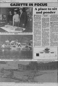 Whitehorse Historical Society Inc.
Newspaper - Article, A Place to sit and ponder, 25/04/1990
'A Place to sit and ponder' by Kate Ashley-Griffiths, Nunawading Gazette, 25 April 1990 on Blackburn Lake Sanctuary. Gives brief history and discusses plans for expansion of the visitors' centre.blackburn lake sanctuary, hansen, bill, stanton, peter, armstrong, ian -
Whitehorse Historical Society Inc.
Map, Nunawading, Ringwood and Scoresby, 16/02/1858 (original)
Plan of country lands in the Parishes of Nunawading, Ringwood and Scoresby in the Counties of Bourke and Mornington. Lithographed at the Public Lands Office, Melbourne, 16 February 1858. Inset: Pound Reserve, Nunawading.nunawading, ringwood, scoresby, maps -
 Whitehorse Historical Society Inc.
Legal record - Document, Melbourne Metropolitan Planning Scheme, 1987
Explanatory Statement of Amendment 500 to Melbourne Metropolitan Planning Scheme, including map of area (South of Blackburn Station). To be exhibited from 2 October 1987 to 22 December 1987.roads and streets, victoria. ministry for planning and environment, city of nunawading, south parade, blackburn, blackburn road, blackburn, main street, blackburn -
 Whitehorse Historical Society Inc.
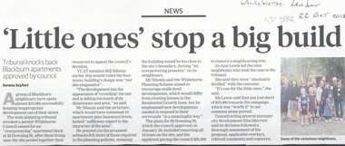
Article, Little Ones' Stop a Big Build, 2018
The State planning tribunal revoked a permit Whitehorse Council issued for an 'Overpowering' apartment block at 20 Downing Street, Blackburn.The State planning tribunal revoked a permit Whitehorse Council issued for an 'Overpowering' apartment block at 20 Downing Street, Blackburn. Local residents spent $10,000 fighting the proposed development.The State planning tribunal revoked a permit Whitehorse Council issued for an 'Overpowering' apartment block at 20 Downing Street, Blackburn. downing street, blackburn, no.20, planning development, city of whitehorse -
 Whitehorse Historical Society Inc.
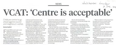
Article, VCAT : Centre IS Acceptable, 2018
Forest Hill is set to get a new childcare centre at 310-312 Springvale Road despite the protests from Whitehorse Council after the applicant's plans were approved by VCAT.Forest Hill is set to get a new childcare centre at 310-312 Springvale Road despite the protests from Whitehorse Council after the applicant's plans were approved by VCAT.Forest Hill is set to get a new childcare centre at 310-312 Springvale Road despite the protests from Whitehorse Council after the applicant's plans were approved by VCAT.city of whitehorse, forest hill, springvale road, no.310 -312