Showing 11471 items matching " maps"
-
 Bendigo Historical Society Inc.
Map - CAMPBELL COLLECTION: BENDIGO AND DISTRICT MAPS
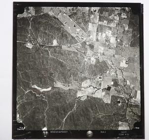
Map. Two aerial photographs of Kangaroo Flat and Lockwood (part). Crusoe Reservoir bottom right corner on Crusoe Road, shows Merindah Road running between Lockwood and Crusoe Roads. Map Name : Bendigo Mapsheet Run 2. 14-2-71, 13,200 A.S.L.. Map shown with NORTH at bottom of page, VIC 2479 at corner. Map 2 continues to the west. A joined copy of both photographs is also included.map, bendigo, agricultural lands -
 Robin Boyd Foundation
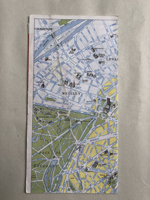
Map, Blondel La Rougery, Find Your Way in Paris, 1959
Map marking the Printemps department stores and significant urban landmarks in Paris; maps of Paris Metro and Autobus on reverse/ Blondel La RougerySmall scribbles on the advertising pages, indecipherable.paris, paristemp, map, transport map, walsh st library -
 Phillip Island and District Historical Society Inc.
Sketch
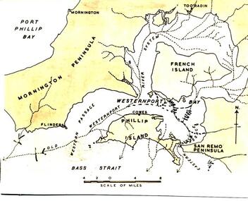
One of a collection of over 400 sketches & photographs in an album commenced in 1960 and presented to the Phillip Island & Westernport Historical Society by the Shire of Phillip IslandSketch map of Westernport Bay region showing probable drainage directions of the ancient river system. Drawn by Dr G Baker from original maps by E S Hills D.Sc.local history, illustrations, pen & ink, westernport bay region, black & white sketch, physiography, dr g baker, e s hill d.sc, john jenner, bryant west -
 Orbost & District Historical Society
book, Effingham, Wilson, A Geographical Dictionary of the Australian Colonies, 1848
A geographical dictionary or gazetteer of the Australian colonies : their physical and political geography : together with a brief notice of all the capitals, principal towns, and villages. William Wells travelled to Australia as a sponsored immigrant in 1838. Her became a freelance surveyor with an office in Bligh Street, Sydney. He wrote this book in order to better inform the British public on the colonies of Australia. The information contained in the book is both topographical and statistical and was a very useful refernece book at the time.This book is a rare detailed contemporary record of the Australian colonies in the mid 19th century.A hard back 453 pp book with a dark brown patterned cover which has a white label with the title, "Dictionary of Geography" over a map of Australia. It is illustrated with numerous maps and drawings.history-australia wells-william-henry geographical-dictionary-of-the-australian-colonies -
 Bendigo Historical Society Inc.
Map - CAMPBELL COLLECTION: BENDIGO AND DISTRICT MAPS
Map. Ellesmere, Parish of Ellesmere. Scale 20 chains to 1 inch. Total area 3926 acres. Prepared in W.P.B. from A and P plans. (number 354 in map cupboard 1)map, bendigo, agricultural lands -
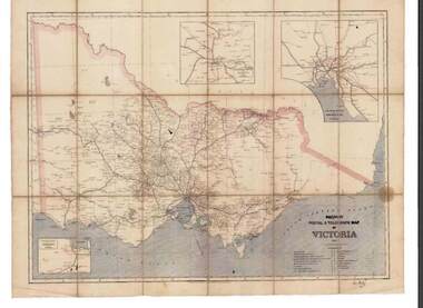 Bendigo Historical Society Inc.
Map - RAILWAYS COLLECTION: PHOTO OF RAILWAY POSTAL & TELEGRAPH MAP OF VICTORIA 1887, 1887
RAILWAYS COLLECTION- photo of Railway Postal & Telegraph Map of Victoria 1887- aged map showing the various Country Lines and insets show Melbourne and vicinity, Ballarat and vicinity and Geelong and vicinity.Picturesque Atlas Publishing Companyphotograph, railway postal & telegraph map of victoria 1887- -
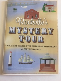 Port Melbourne Historical & Preservation Society
Pamphlet - Rochelle's Mystery Tour, bicycle tour of Port Melbourne identifying historic locations, Rochelle BELL, Rochelle's Mystery Tour, Jan 2017
Coloured 4 fold pamphlet with map, photographs of historic bike tour through Port Melbourne. Inside is large map marked with points of interest corresponding to photo and information on reverse sideRochelle's Mystery Tour a ride through the history and environment of Port Melbournebuilt environment, recreation, social activities, celebrations fetes and exhibitions, piers and wharves - princes pier, piers and wharves - station pier, rochelle bell, social health inclusion program (ship), danielle mccaffrey, centenary bridge, natural environment - beaches and foreshore, band rotunda, westgate park, lagoon reserve, liardet community centre, sandridge trugo club, garden city -
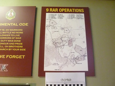 National Vietnam Veterans Museum (NVVM)
Map, 9 RAR Operations
Maroon coloured board with 9RAR Operations. Map of Vietnam inside a white rectangle are regions mared on with outlines and numbered. Just above the map are numbers and operations, dated, that match the region marked.9RAR Operations 1. King hit one 10-11 Dec 68 2. King hit two 12-24 Dec 68 3. Goodwood 1 Jan-17 Feb 69 4. OP Federal 17 Feb-2 April 69 5. OP Overland 2-10 April 69 6. OP overlander 11-15 April 69 7. OP Surfside 16-23 April 69 8. OP Reynella 8May-15June 69 9. OP Matthew 29 June-17July 69 10. Op hatditch 18-31 July 69 11. OP Neppabunna 18 Aug-15 Sept 69 12. OP Jack 30 Sept-31 Oct 699 rar, map -
 Bendigo Historical Society Inc.
Map - JACK FLYNN COLLECTION: HUNTLY, 12.03.1932
Map: Township of Huntly, Parish of Huntly , County of Bendigo. Parish plan. Western and South Riding Division on Main St. (Main Northern Highway) - written in ink below name of map.BY Authority H.J. Green. Photo-Lithographed at the Dept., of Lands and Survey, Melbourne. 12.3.32map, bendigo, township, huntly -
Bendigo Historical Society Inc.
Map - SANDHURST : COUNTY OF BENDIGO (PART), Circa 1940's
Map: Large scale (2 chains=1') of part of the city of Bendigo. Showing the area from Sommerville St. to Edwards Rd. Flora Hill ( number 195 in Map Cupboard 1)map, bendigo, city streets, bendigo, flora hill, sommerville st. -
Bendigo Historical Society Inc.
Map - PLAN OF THE BENDIGO RAILWAY YARD, Circa 1960
Map: Plan of the Bendigo Railway Yards, Scale: 80 feet to 1 inch. 1960's. (number 319 in map cupboard 1) Location unknown. Image in Mosaic images overflow.map, bendigo, railway yard, railways, rail yards, station layout -
Whitehorse Historical Society Inc.
Document, What happened to Norwich?
Norwich, consisting of 475 acres in the Parish of Nunawading, County of Bourke, found on a land sale map in the La Trobe collection of Vale maps.Norwich, consisting of 475 acres in the Parish of Nunawading, County of Bourke, found on a land sale map in the La Trobe collection of Vale maps. Research by Jean Uhl into the fate of the proposed township.Norwich, consisting of 475 acres in the Parish of Nunawading, County of Bourke, found on a land sale map in the La Trobe collection of Vale maps. local history, uhl, jean, parish of nunawading, norwich village, vermont, lobb, john, graham, thomas -
Bendigo Historical Society Inc.
Map - PANNOOMILLOO : COUNTY OF BENDIGO, 1957
Map. Pannoomilloo, County of Bendigo, Pannoobamawm, Milloo, Warragamba, Diggorra, Property Allotments. Drawn and Reproduced at the Department of Lands and Survey,1957. Price 2/-. (number 412 in Map Cupboard 1 ).W.M. Houston, Government Printer, Melbourne.bendigo, hospital -
Tarnagulla History Archive
Photocopies of historic maps - Tarnagulla region, varied
David Gordon Collection. Four photocopies in clear sleeve: (a) topographic with mines near Tarnagulla (b) Parish map ?- Tarnagulla & surrounds (c) Parish map ?- Tarnagulla & surrounds (d) Plan of Roads, Tarnagulla & Newbridge -
Port Melbourne Historical & Preservation Society
Poster - Map showing ancesttral family estates of Melbourne's first people pre European Settlement, Marcus Lee Design, This once as it was - the ancestral family estates of Melbourne's first people, 2016
This once as it was - the ancestral family estates of Melbourne's first people. Colour map with text. Pre European settlement. Based on Colonial survey maps of Port Phillip Bay region. 1837 and 1864indigenous australians, natural environment, arweet derrmut, point ormond, st kilda, yuro yuroke, bunjil, burrarung river, queensbridge falls -
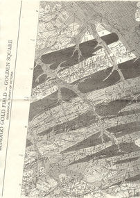 Bendigo Historical Society Inc.
Map - LONG GULLY HISTORY GROUP COLLECTION: BENDIGO GOLD FIELD - GOLDEN SQUARE GEOLOGICAL SURVEY OF VICTORIA
BHS CollectionPart of a map of the Bendigo Gold Field - Golden Square. Geological Survey of Victoria. Shown are reefs, faults and anticlines. Many of the mines are shown on the map. Gullies, hills and streets are also shown.bendigo, history, long gully history group, the long gully history group - bendigo gold field - golden square geological survey of victoria, north bendigo state school reserve, hospital reserve, benevolent asylum reserve, empire hill, richmond hill, raes hill, south end hill, victoria hill, new chum hill, iron bark hill, redan hill, view hill, hustlers hill, camp hill -
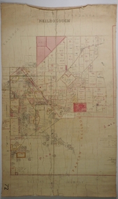 Bendigo Historical Society Inc.
Map - NEILBOROUGH, 21/01/1875
Map: Parish of Neilborough, County of Bendigo. Hand draughted Parish plan. Resurveyed by Mr Assistant-Surveyor G Black. Drawn by W A Taylor. Map dated 21/1/1875.map, bendigo, parish plan, neilborough, g. black, w.a. taylor -
 Phillip Island and District Historical Society Inc.
Booklet, Phillip Island Holidays Development Pty Ltd, Ideal Summerland on the Nobbies, Phillip Island, Late 1920s
Subdivision of Summerland commenced in the 1920s with 12 large allotments created, along with features such as a roundabout and cypress trees. Between 1927 and 1931, 227 new blocks were created, and from 1929 to 1940 there was a nine-hole golf course on what is now the Penguin Parade car park.Historical Large 8 page glossy booklet advertising Summerland Estate, describing attractions of the area ,maps, houses , golf course. Basically black and white with some orange print and a coloured map.Ideal Summerland on the Nobbies Phillip Island. "The land of somewhere we long to go". Published by Phillip Island Holidays Development Pty Ltd. 6o Market Street, Melbourne.housing, tourism phillip island, summerland estate -
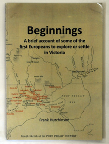 Orbost & District Historical Society
book, Beginnngs, 2011
"A map on the wall of his parent's shop in country Victoria is what got Frank Hutchinson interested in the geography and early settlement of Victoria. He later moved to Ballarat where he spent most of his working life. Whilst there his interest in the early explorers continued until about ten years ago he began to compile the listing which developed into the present publication." (ref.Port Phillip Pioneers Group) When he commenced the research and writing of Beginnings, it was not intended for publication. It was a project of personal interest. A soft covered 122 pp book title Beginnings a brief account of the first Europeans to explore or settle in Victoria. On the glossy front cover is a rough map of Port Phillip Bay. Print is black. a chronological list of the earliest visits to Victoria and attempts to settle. The book contains: brief notes on the exploration and earliest settlement of the state, region by region and a summary of the early Murray River paddle steamer industry.hutchinson-frank history-victoria prahran-mechanics-institute -
 Eltham District Historical Society Inc
Document, Russell Yeoman, Tour of Historic Buildings and Locations, 1978
Self guided heritage tour information produced by the Shire of Eltham Historical Society for 1978 Eltham Community Festival of 36 locations each numbered on accompanying map. Locations and detail provided current to 1978: 1. ELTHAM SHOPPING CENTRE Whilst very little remains in the centre of historical importance, this area has interest as the "village" which developed over many years following the opening of the railway from Melbourne in 1902. Previously the shopping centre had been spread out over a long length of Main Road to the south. Shops have been continuously demolished or remodelled and the majority of buildings date from the 1950's or later. The recently erected Post Office replaced the "old" Post Office opened on the same site only in 1958. 2. WOOLWORTHS ELTHAM VILLAGE Part of the site of this modern shopping development was occupied by the former Eltham Shire Offices and Hall. The hall was paid for by public subscription whilst the Council raised a loan for the offices. The combined building was opened in 1941. It served as office and Council meeting place until 1965 and as the hall until its demolition in 1970. 3. ELTHAM WAR MEMORIAL The complex of buildings adjoining the present Shire Offices were financed by public subscription as a Memorial following World War II. Their construction and for many years their operation was organised by the now disbanded Eltham War Memorial Committee. The original buildings were the; Infant Welfare Centre, Children’s Library (now War Memorial Hall and Dental Clinic) and Kindergarten. In later years the Elderly Citizens Club was built at the rear. 4. ELTHAM SHIRE OFFICES These offices were opened in 1965 and extended in 1971 to provide additional office accommodation and the Eltham Library. They represent the last of a long line of offices and meeting places of the Eltham Shire Council and its predecessor the Eltham District Road Board. The building occupies the former site of Shillinglaw Cottage. The three tall cypress trees which stood in front of the Cottage have been retained as a feature of the office surrounds. 5. OUR LADY'S CHURCH AND SCHOOL The Catholic Church and School complex opposite the Shires Offices shows a number of stages in the development of Eltham township. The recently constructed church adjoins its predecessor (now the parish centre). Many years ago the Catholic Church was located opposite Wingrove Park and the present central site follows the northerly drift of the township. 6. SHILLINGLAW COTTAGE The Cottage was built in 1859 by George Stebbing, a local builder who was responsible for a number of other prominent buildings in the area. Its removal from the site of the Shire Offices and re-erection on the present site was financed by public subscription. It is built of handmade bricks laid in Flemish Bond with an unusual design featuring burnt "leader" bricks over the whole facade. The Cottage is occupied by Eltham Fleececrafts and will be open during the Festival and at other times during weekends. It is classified by the National Trust. 7. RAILWAY BRIDGE The timber trestle bridge over the Diamond Creek was built in 1901. Whilst all of its timbers have been replaced at various times over the years the only change to its character has been the addition of pylons and wiring for electric trains in 1923. It is one of very few similar bridges remaining in the metropolitan area. In 1976 a proposal to replace the bridge with an earth embankment and large culvert pipes was abandoned following community protests. The bridge, however, remains under threat because of the necessity for future deuplication of the railway line. 8. ELTHAM CENTPAL PARK The area between the railway and the creek has for many years been used as a park which included Eltham' s main football oval. The access road, Panther Place is named after Eltham's team playing in the Diamond Valley League. In recent years a large area extending to Bridge Street and locally known as the Town Park has been landscaped and added to the area. The excellent blending of the park with the natural landscape of the creek valley has earned a National Trust Landscape Classification. 9. OLD BAKERY On the southern corner of York Street and Main Road is an old house with a shop front which was for many years the local baker's shop. The brick bakery at the rear is of somewhat later vintage than the house. 10. BRIDGE STREET CUTTING Before reconstruction of Main Road this intersection had deep cutting embankments on all four corners, forming a distinctive feature of the entrance to Eltham. Roadworks and private development have levelled the land on the low side of the road. A memorial to the Eltham soldiers of World War I which was located at the north-western corner is now situated at the Eltham R.S.L. 11. HILLTOP MILK BAR For many years this was the site of the Eltham Post Office under the control of the Hunniford family and later their descendants the Burgoynes. It was transferred to this site in 1855, although at that time the building apparently fronted Bridge Str e et. The site contained Eltham's first telephone exchange. The post office was relocated in 1954 but the shop was operated until recently by the Burgoyne family who still own the surrounding land. 12. UNITING CHURCH and former C.B.A. BANK The former Methodist Church was built in 1880 by George Stebbing. The Sunday School extension was built in 1929 and there have been more recent extensions. The adjoining opportunity shop was built as a bank in 1874 and purchased by the Methodist Church in 1954. 13. R.S.L. HALL, TELEPHONE EXCHANGE These relatively recent buildings occupy the site of a row of shops forming part of the early ribbon of business development along Main Road. In front of the R.S.L. building is the World War I Memorial relocated from the corner of Bridge Street and Main Road. 14. ELTHAM COMMUNITY CENTRE Australia's first mudbrick "community building" was opened in April this year. Part of the site of the building was purchased in 1856 by Henry Dendy (of Brighton fame). At the rear of the land near the creek was a steam flour mill whilst Dendy's house was at the Main Road frontage of the land. His purchase totalled about 2 Ha (5 acres) and included land on the opposite side of Maria Street (Main Road). Dendy became a prominent member of the Eltham community and served one term as President of the Eltham District Road Board. In 1867 Dendy sold his land and business to William Ford of Malmsbury and shifted to Walhalla. The avenue of trees leading past the Community Centre to the creek may well have bordered the track to the mill. 15. ELTHAM HOTEL The original part of this hotel was built in 1927 following the burning of the former Watson's Eltham Hotel on the same site. The car park on the opposite side of Main Road was also the site of a hotel variously known over the years as; the Fountain of Friendship, the Fountain and the Evelyn Arms. As the Fountain of Friendship it was the first meeting place of the Eltham District Road Board in 1856. 16. ST. MARGARET'S CHURCH, PITT STREET In 1860 Henry Dendy was appointed Chairman of a committee to establish a church of England in Eltham. He donated part of his land in Pitt Street and in 1861 the church was opened. It was built by George Stebbing and remains in a well preserved state today. Th adjoining old vicarage is now named Dendy Hou se. A new mudbrick church hall is under construction on the site. The church and Dendy House are now listed on the Register of Historic Buildings. 17. NO. 86 PITT STREET Cottage built by George Stebbing and believed to be his home for some years in the 1850s. 18. LIVING AND LEARNING CENTRE The house was built in the 1850s with the kitchen at the front being added about 40 years later. By the creek below the house a number of early Eltham industries were located. These included a tannery and a brewery. 19. ELTHAM COURT HOUSE A Court of Petty Sessions was established in Eltham in 1858 and the present building dates from 1860. It is the oldest public building remaining in Eltham. In its early days the building was used as the meeting place and office of the Eltham District Road Board and as an overflow classroom for the local school. The Court House has been classified by the National Trust. The citation states that it is an example of the simple form of early brick Court House with gabled roof and porch. 20. LANDS DEPARTMENT OFFICE This building is the former police station and is probably of about the same age as the Court House. The lockup at the rear has been demolished but the old stables remain as garages. A licence was first granted for a police station at Eltham in 1856. 21. JARROLD COTTAGE The old Cottage opposite Dalton Street was formerly owned by the Jarrold family. Early records indicate that this was the building leased from the Jarrolds as a temporary police station prior to construction of the building on the corner of Brougham Street. The small building on the corner of the property was used as a boot repairer's shop. The elevated studio at the rear is a more recent construction by the present owners. 22. STATE SCHOOL RESIDENCE Erected in 1891 23. WINGROVE COTTAGE This building fills an important place in the history of Eltham and is now used as a medical clinic. It was built in 1858 for Charles S. Wingrove who was Secretary to the Eltham District Road Board and Shire Council from 1858 to 1904. During part of this period he was also Shire Engineer and was Secretary to the Heidelberg Road Board. The house was used as the office of the Board and Council for many years. Wingrove is buried in the cemetery at St. Helena. 24. WINGROVE PARK The parkland opposite Wingrove Cottage has been named after Charles Wingrove. The old Manna Gums are an outstanding feature of the park. 25. ELTHAM FRI.MARY SCHOOL NO. 209 The school first opened in the slab building in 1855 and operated from the present site since 1857. The oldest part of the present school is the stone building erected in 1876. The first school teacher, David Clark remained at the school until 1888. This school is the government township and has always been known as the Eltham School. An earlier school (no.371) known as Little Eltham School operated in Swan Street from 1853 to 1872. 26. "SHOESTRING" This house was built for school teacher David Clark. It has been extensively extended in recent years but the extensions do not detract from the character of the older part of the building. 27. ELTHAM CEMETERY The cemetery contains the graves of many of the district's pioneers . 28. MONTSALVAT This unique complex of buildings was commenced in 1935 by the late Justus Jorgensen and its development has extended over many years. Montsalvat has exerted a significant impact on Eltham The earth and stone construction of many of the buildings has influenced local architecture to a great extent and it has served as a "nerve centre" of the local artistic community. Montsalvat is open to the public for a small charge. 29. MAIN ROAD BRIDGE This location has been the main crossing of Diamond Creek since the earliest days of settlement. The present concrete bridge was erected in 1925 .and was preceded by a number of timber bridges. 30. ELTHAM LOWER PARK This park, being an unusually large flat area for Eltham, was originally the local racecourse. Horse races were held here from 1855 and the area was gazetted as a reserve for a racecourse and recreation reserve in 1857. The park is well known as a venue for school "bird days" and more recently as the site of the Diamond Valley Railway. This miniature railway features scale models of modern and old locomotives and rolling stock and has operated on this site since 1961 . Before that the railway operated at Chelsworth Park, Ivanhoe. 31. FALKINER HOUSE Frederick Falkiner was one of the earliest settlers in the Eltham township area and occupied a substantial leasehold prior to the first land sales. Early records show that Falkiner was the subject of a number of complaints from his neighbours but he has nevertheless been considered a prominent enough citizen to have a street named for him. This house was the home of Evelyn (Ely) Falkiner a member of Frederick's family. 32. WEST HOUSE Behind the large house on the hill is an early house built by the West family. This was relocated from a site near the front of the land by the present owner Mr. Fabbro. 33. FALKINER HOUSE This very old house is believed to have been the home of Frederick and may have been Eltham's first post office. Falkiner was the first post master for a short period. in 1854/55. 34. WITHERS HOUSE This house was the home of famous artist Walter Withers who shifted here from Heidelberg in 1903. 35. ELTHAM HIGH SCHOOL This school celebrated its jubilee this year, having commenced as the Eltham Higher Elementary School 50 years ago. 36. DIAMOND CREEK FOOTWAY If returning from the High School to the town centre the footpath by the bank of the Diamond Creek provides a pleasant route to finish your walk. The creek is a major tributary of the Yarra River. Together with its own major tributaries Arthurs Creek and Running Creek it commences on the southern slopes of the Dividing Range at Kinglake. It gives the name Diamond Valley to an area extending well beyond its actual drainage catchment.Recognition of the significance of various landmarks to the history of the Eltham community as of 1978‘shoestring’, 1978, bridge street cutting, burgoyne store, c.b.a. bank, diamond creek trail, eltham cemetery, eltham central park, eltham community centre, eltham community festival, eltham court house, eltham festival, eltham high school, eltham hotel, eltham lower park, eltham primary school, eltham railway trestle bridge, eltham shire offices, eltham shopping centre, eltham state school no. 209, eltham village, eltham war memorial, falkiner house, heritage trail, hilltop milk bar, jarrold cottage, lands department office, living, living and learning centre, main road bridge, montsalvat, old bakery, our eltham artistic recollections, our lady help of christian’s church, our lady help of christian’s primary school, pitt street, post office, r.s.l. hall, shillinglaw cottage, st margaret’s church, state school residence, stebbing cottage, telephone exchange, uniting church, west house, wingrove cottage, wingrove park, withers house, woolworths -
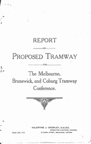 Melbourne Tram Museum
Document - Photocopy, Valentine J. Crowley Consulting Engineer, "Report on Proposed Tramway for The Melbourne, Brunswick and Coburg Tramway Conference", Original 1915
... Maps ...Photocopy - Report - 12 pages - titled "Report on Proposed Tramway for The Melbourne, Brunswick and Coburg Tramway Conference", prepared by Valentine J. Crowley Consulting Engineer Oct. 25, 1915. Looks at the construction of a tramway Flinders St along Queen St, to Royal Park, to Sussex St and Gaffney Road, West Coburg for the Melbourne Brunswick and Coburg Tramways Trust. Looks at the route and length of track in detail, route, administration, population, construction, permanent way, overhead lines, feeders, rolling stock, timetable, capital cost, alterations to services, expenditure for year and conclusion. Has a map of the proposed route. Included with the document is a plan of the MBCTT lines, overwritten in ball point pen with street names dated Dec. 1919. Photocopy made from original documents - has been stapled along the side in three places.trams, tramways, mbctt, maps, new tramway, west coburg, queen st, royal park -
Bendigo Historical Society Inc.
Map - GEOLOGICAL MAP: BENDIGO GOLD FIELDS
GEOLOGICAL MAP - BENDIGO GOLD FIELDS - Donated by JOHN HORWOOD. Two geological maps of the Bendigo Gold fields. The maps display , reef lines, Hills, Dams and mine locations. Also Anticlines, sinclines, shafts, alluvial deposits, contours and gullys. All items are superimposed on a map of the major roads and streets of Bendigo. The maps were printed by The Victorian Minister for Mines in 1923 and re-issued in 1936. The maps have been specifically framed and donated to The Bendigo Historical Society Inc. in May 2015 for display at Specimen Cottage. John had been a student at The School of Mines- Bendigo and found them useful as a student living in Bendigo. Prior to being framed , the maps have been kept rolled up in his home. Accession Number 309/15 Were on Display at Specimen Cottage 2015 - 2020. After all items removed from SC to the BRAC in 2021 the framed maps could not be located. Search ongoing. BP 2.3.2023Victorian Minister of Minesgoldfields -
Glenelg Shire Council Cultural Collection
Map - Map - RACV Road Map, 1970s
RACV road map, Portland district, Port MacDonnell to Warrnambool. Large coloured map of Portland District, small maps of Portland, Mt Gambier, Hamilton, Mount Eccles National Park, Coonawarra Wineries. When folded, black and white phot of child fishing on jetty on Moyne River, Port Fairy on coverroad touring, racv, map -
Friends of Ballarat Botanical Gardens History Group
Work on paper - Gondwana Trees in the Ballarat Botanical Gardens, Categories and Common Features, Unknown
Part of an attempt to to categorise and identify common features of the wide range of trees in the Ballarat Botanic Gardens.This material deals with the history of Gondwana trees and those represented in Australia today that relate to plants found in the Ballarat Botanical Gardens.4 pages. p.1 Map of Pangaea (Continents) left hand 2nd half of page. p2. Map, left hand top of page and 2 photographs of foliage, 2nd half of page. p 3. 5 small photographs down left hand side of page. p.4 no photographs or maps. none.john garner, doctor, ballarat botanical gardens, gondwana trees in the ballarat botanical gardens, pangaea, trees., john garner collection, gardens, ballarat -
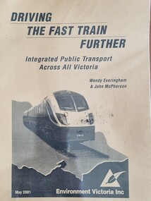 Wodonga & District Historical Society Inc
Booklet - Driving the Fast Train Further, Wendy Everingham and John McPherson, May 2001
This document is a response by Environment Victoria to the Fast Train Report. It advocates the establishment of an integrated transport approach in Victoria including the need for a Rural and Regional Planning Strategy to be developed in conjunction with the Metropolitan StrategyA publication of 34 pages produced by Environment Victoria Inc. It has brown cover featuring an image of a locomotive superimposed over an outline map of Victoria. It consists of 36 pages including appendices, references, a map of an Environment Victoria Enhanced Victorian Passenger Rail Network and a map of the Victoria's Regional and Rural Bus service.fiction This document is a response by Environment Victoria to the Fast Train Report. It advocates the establishment of an integrated transport approach in Victoria including the need for a Rural and Regional Planning Strategy to be developed in conjunction with the Metropolitan Strategyrailways environmental impact, victorian railways, environment victoria -
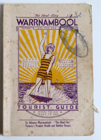 Warrnambool and District Historical Society Inc.
Booklet - Warrnambool Tourist Booklet, Warrnambool Progress Association, Warrnambool On the Sea, Victoria, Australia, Tourist Guide, 1932
Warrnambool Tourist GuideThis is a booklet with a cream cover featuring a sketch of a woman waterskiing and blue printing. The pages contain black and white photographs, advertisements, two maps and printed text. There is one fold-out page. The booklet is stapled and bound with glue.non-fictionWarrnambool Tourist Guidewarrnambool tourism, warrnambool progress association -
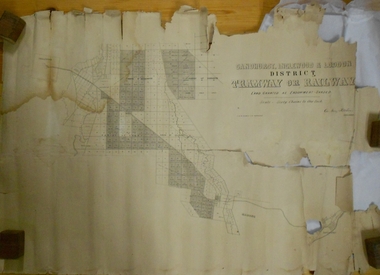 Bendigo Historical Society Inc.
Map - MARKS COLLECTION: TRAMWAY OR RAILWAY MAP SANDHURST
Original map of 'land granted as endowment' for tramway or railway. On top Rh corner of map, in bold print 'Sandhurst, Inglewood & Loddon district Tramway or Railway. Land granted as endowment shaded, scale 60 chains to 1 inch. Lithographed by J & W. Holmes, Lith. Sandhurst'. Signed by Geo Avery Fletcher, Engineer. Map shows Parish of Leichardt, Parish of Yarraberb, Parish of Bridgwater and a section of Marong. On bottom RH corner, is small map of Sandhurst, showing railway reserve. Top LH corner, Inglewood. Map shows route of railway line from Sandhurst to Inglewood.map, marks collection, railway, inglewood -
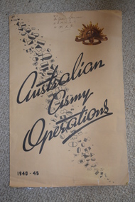 Wangaratta RSL Sub Branch
Map, Australian Army Operations 1940-45
Large fold out map and chronology of Australian Army Operations between 1940-1945 that belonged to Private Joan Spencer VFX12932 (VF507134) born 12/11/1924 at Albury. The family moved to Wangaratta and Joan was educated at Wangaratta High School before joining the Australian Army Medical Women's Service at 115 (Heidelberg) Military Hospital. She served with the 130 Australia General Hospital and was deployed overseas to Japan on 17/6/1947 and returned on 26/1/1949Large cream coloured cardboard folded in three, inside is a coloured map of the Middle East 1940-1942, New Guinea Theatre 1942-1944, Pacific Islands 1944-1945 and Malay and Islands 1942-1945. Front cover has Unit patches from top left to bottom right corner , at top right corner is the rising sun badge and bottom left corner 1940-45 Back cover is a listed Chronology.Hand written at top - VFX Pte Joan Spencer AAMWS 115 (H) M.H.australian army operations, private joan spencer, aamws, 130 agh -
Southern Sherbrooke Historical Society Inc.
Information folder - Belgrave Heights Convention Ground
Information folder containing items pertaining to the history of the Belgrave Heights Convention Grounds. Contents: -map, "Belgrave District Road Map" showing locations in Belgrave Heights & South -map "Belgrave Heights Road Map" showing Convention Grounds, buildings and other local sites -Various items photocopied on single sheet, inc. token for Gospel Supplies, Belgrave Heights; item re. Rudi Atwood, minister; list of hymns; photo of Main St, Belgrave. -
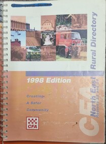 Wodonga & District Historical Society Inc
Book - North East Rural Directory 1998
The CFA North East Rural Directory for Regions 23 and 24 was designed to assist fire brigades and other emergency services in responding to calls in the North East region of Victoria. Its purpose was to minimize response times to emergency situations by providing accurate and detailed information about all of the localities in the regions. District 23 is based at Wangaratta and Extends as far south as Woods Point. District 24 is centred in Wodonga and extends past Corryong to the New South Wales border following the Murray River. It also includes Falls Creek and Mount Hotham.A spiral bound volume including colour topographic maps and illustrations of North East Victoria. The cover features a collage of colour photo of North East Victoria including a CFA firefighter in a truck with members of his family beside it. The book also features a key map, explanation of map references and symbols, localities index. Alphabetical road indexes for Wodonga, Albury, Wangaratta and Benalla as well as township maps and alphabetical road indexes for smaller communities are included.The CFA North East Rural Directory for Regions 23 and 24 was designed to assist fire brigades and other emergency services in responding to calls in the North East region of Victoria. Its purpose was to minimize response times to emergency situations by providing accurate and detailed information about all of the localities in the regions. District 23 is based at Wangaratta and Extends as far south as Woods Point. District 24 is centred in Wodonga and extends past Corryong to the New South Wales border following the Murray River. It also includes Falls Creek and Mount Hotham.emergency management north east victoria, cfa region 24, cfa wodonga, cfa region 23