Showing 10393 items
matching plan
-
 Ballarat Heritage Services
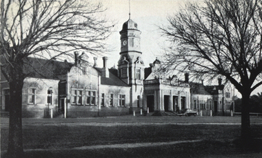
Photograph - Image, Maryborough Railway Station, c1951
Maryborough Railway Station was built in Victoria's heyday of railway planning. A black and white photograph of Maryborough Railway Stationmaryborough railway station, maryborough, architecture -
 Robin Boyd Foundation
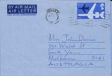
Letter - Aerogram, John Barry, 20.03.1978
To Patricia Davies from John Barry, London, with travel plans. -
 Friends of Ballarat Botanical Gardens History Group
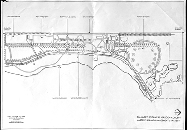
Work on paper - Ballarat Botanical Garden Concept, Masterplan and Management Strategy, Unknown
This map is important in terms of the planning and management of the Ballarat Botanic Gardens The Map adds to our understanding and knowledge of the history of the Ballarat Botanical Gardens 1 page of a map in black and white. the number 44 is circled in pencil on the top righthand corner of the back of the page.john garner, doctor, john garner collection, ballarat botanic gardens, maps, masterplan, management strategy, john patrick, landscape consultants, ballarat city council, friends of ballarat botanical gardens, gardens, ballarat -
 City of Kingston
Pamphlet - Colour, W. H. Wood Estate Agent, Subdivisional Land Auction Barker's Estate Cheltenham, 1919
Sales plan for land in the suburb of Cheltenham, along Barker StreetThe developing urban area of Cheltenham within the City of Kingston. This land sale pamphlet illustrates the subdivision of land within the municipality and the changing demographic of the district as new houses are constructed.Colour pamphlet advertising subdivisional land auction of Barker's estate, on Barker Street Cheltenham.Handwritten in grey pencil on the subdivision map: a series of numbers on each block possibly indicating the sale price. Handwritten in grey pencil on the subdivision map: Roy- joined to subdivision 6 Handwritten in grey pencil on the subdivision map: x on the border between subdivision 17 and 16, and again on the border between subdivision 12 and 11.cheltenham, land sales, estate -
 Greensborough Historical Society
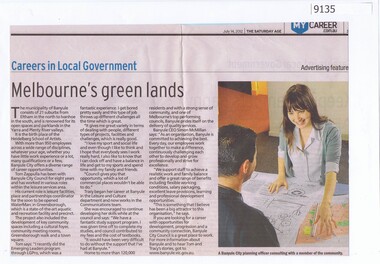
Article - Newspaper Clipping, The Age, Careers in Local Government - Melbourne's green lands, 14/07/2012
Discusses employment at Banyule City Council in particular the planning departmentNewspaper text and colour imagebanyule city council, town planning -
 Bendigo Historical Society Inc.
Document - MARKS COLLECTION: PLAN RELATING TO UNDERGROUND AND SURFACE WORKINGS VICTORIA HILL
Plan on paper: on top of plan 'plan showing the position of the underground & surface workings in the claim of Mr. Ballerstedt Victoria Hill' Signed by Thomas Forbes, Mining Surveyor, 22nd. April 1868' Attached to plan is a letter report accompanying plans on the underground workings in (illegible) Ballerstedt & Sons, Victoria Hill (ink blot covering writing RH side) Text of letter begins : the underground level southwards from the shaft is 4ft 6' x 6 ft wide as shown on the plan; and is at a depth of (illegible) from the surface; along the (illegible) of which the timbering both upright and cap-pieces; are now in as good condition as when the work was being proceed with; with the exception of the uprights and one cap-piece which are slightly crushed from the general settlement of the mullock. The timbering of the drives are still standing in the same position though upwards of 12 months has elapsed after the slip in the open cutting had taken place, showing very clearly in my mind that the slip could not be attributable to the insufficient timbering of the underground workings; but rather to the action of the weather in this particular part of the cutting. The probably quantity of mullock that was detached or slipped from the west side of the cutting; would be (from careful enquiry and observation ) about 1500 loads at least; enough to crush the whole of the timber in the levels, if it had not been of the most substantial character and I think yours to prove that the fall was not caused by any defective timbering but from the cause already stated. I may state that I have inspected the underground workings generally in the mine, and the timbering is of the most substantial characterbendigo, mining, victoria hill -
Whitehorse Historical Society Inc.
Article, An open or shut case
After Nunawading Council rejecting Club 25's appeal for a planning permit for a brothel in Mitcham.After Nunawading Council rejecting Club 25's appeal for a planning permit for a brothel in Mitcham. Owner of the brothel, Bruce Roberts, has appealed to the Planning Appeals Tribunal and his appeal is to be heard 20 September. A new group has been set up and funds raised from St John's Catholic Church, Mitcham, Brothel Action Reform Group to support the anti-brothel group and have engaged legal experts.After Nunawading Council rejecting Club 25's appeal for a planning permit for a brothel in Mitcham. brothels, st johns catholic church, mitcham, rossiter, bob, wattle park gospel chapel, watson, al, roberts, bruce, club 25, brothel action reform group, galbally, frank, victoria. planning appeals board., thornton crescent -
 Eltham District Historical Society Inc
Book, Banyule City Council Aboriginal Heritage Study prepared by Austral Heritage Consultants, 1998 July
A draft report on the pre-European Aboriginal achaeological sites in the city of Banyule, including results of previous field surveys; Banyule covers a small part of the former lands of the Woi Wurrung. The report discusses heritage overlay, planning issues and the proposed Victorian planning provisions.100p, 30 cm.Marked "Draft"aboriginal heritage banyule, woi wurrung -
Port Melbourne Historical & Preservation Society
Document, Port Melbourne Management Framework - Managing Change Draft Report May 2003, 2003
Planning report produced by City of Port Philipp which addresses planning issues affecting Port Melbourne area, from Bay street to Beacon Road. Used as lobbying tool in relation to Beacon Cove Stage 8. Historical section inaccurate and not to be relied upon.Port Melbourne Management Framework - Managing Change Draft Report May 2003. Acetate cover, wire binding, 117 pagespiers and wharves - town pier, town planning, built environment, piers and wharves - station pier, piers and wharves - princes pier, beacon cove -
 Eltham District Historical Society Inc
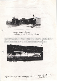
Document - Property Binder, 825 Main Road, Eltham
Photocopy photographs Evelyn Hotel Eltham and Eltham Swimming Pool, images owned by Garreth Burges. Elevations west, north, south, east, of proposed development by Germano Architects. Floor plans of proposed development by Germano Architects. Newspaper article: Council to reject apartments plan, Diamond Valley News, 20 May 1998, Nillumbik Council meeting, protestors against 25 unit development from Eltham Gateway Action Group. Newspaper public notice: Diamond Valley Leader 1 March 2006, Notice of Application for a Planning Permit, by Germano Architects. Newspaper article: Building at long last, Diamond Valley Leader, 3 September 2008, Nillumbik Council approved development plans.main road, eltham, property, businesses, evelyn hotel eltham, eltham swimming pool, eltham gateway action group, germano architects -
Federation University Historical Collection
Document - Report, University of Ballarat Canadian Wetlands Project Report, 2000, 04/2000
1992 - Property purchased fronting Geelong Road, Mount Helen 1994 - Additional adjoining property purchased 1995 - Wetlands included in the Corporate Plan for the area 1997 - Launch of Wetlands Development by Minister Maclennan 1998 - Preliminary planning and plant identification underway - Contract signed for funding 1999 - Stage 1; Planning finalised, earthworks undertaken and weed infestation assaulted - "Work for the Dole" project undertaken - Deluge of rain on Boxing Day provides the centrepiece f the project, the just-completed dam, with a body of water to overflowing level. - Waterbirds move in and the germination of native wetland plant species begins 2000 - Stage 2 plans developed, including additional walkways, bird hides and interpretation. Three page report on the University of Ballarat Canadian Wetlands Project. Direct funding for the project was provided by the University of Ballarat; The Department of Employment, Workplace Relations and Small Business and the Corangamite Catchment Authority.ballarat technology park, canadian wetlands, ian howe, mount helen, mount helen campus -
 Ringwood and District Historical Society
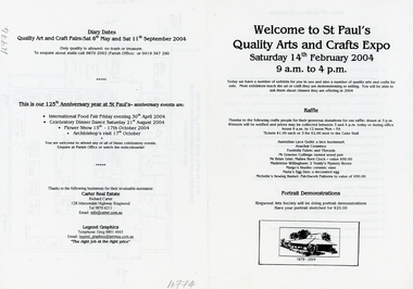
Pamphlet, St. Paul's Quality Arts and Crafts Expo - Ringwood - 2004, 14-Feb-04
Quality Arts and Crafts Expo part of the celebrations at St. Paul's Church, Ringwood on the 125th. Anniversary of the Church. Other events were International Food Fair, April, Celebratory Dinner Dance August, Flower Show October, and Archbishops Visit October.Black and white A4 bifold pamphlet with black printing and B&W sketch of Church on lower front. Plan of stalls on p3. Printing on all pages +Additional Keywords: Carter, Richard -
 Ringwood and District Historical Society
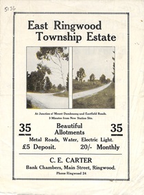
Flyer, Subdivisional Land Sale Brochure, East Ringwood Township Estate, Vic. - 1923
Bi-folded double sided land subdivision sale advertisement with location map and summary of local facilities and services. Includes two additional images of allotment plan with subsequent handwritten notations.Subdivision includes Mount Dandenong Road, Grey Street, and Eastfield Road. Agent - C.E. Carter, Bank Chambers, Main Street, Ringwood. Phone Ringwood 24. -
4th/19th Prince of Wales's Light Horse Regiment Unit History Room
Booklet, Australian Army Manual of Land Warfare Part 2 Vol 1 Pam No 1 Employment of Artillery (All Corps) 1984, 1984
A soft covered booklet describing the role and general principles of field artillery, its equipment and effects, command and communications administration and supply, planning and employment, air defence etc. 2 copies7610-66-118-5456artillery, employment -
 Bendigo Historical Society Inc.
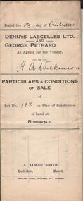
Document - H.A. & S.R. WILKINSON COLLECTIONCONDITION OF SALE
Particulars & conditions of sale of lot no. 188 on plan of subdivision of land at Robinvale between Dennys Lascelles Ltd + George Pethard as agents for the vendor and H. A. Wilkinson (buyer). Price 63 pounds.organization, business, h.a. & s.r wilkinson real estate -
Bendigo Historical Society Inc.
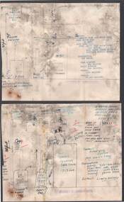
Map - SNOB'S HILL - PLAN OF SNOB'S HILL AREA
Plan drawn on tracing film of sand heap, dams, trig point and mines. Some un-named streets are also drawn in. Piece of notepaper has mines drawn in on a larger scale.map, bendigo, goldfields, snob's hill, plan of snob's hill area, new st mungo mullock heap, duchess trib, s devonshire, duchess of edinburough, w u devonshire, hopewell, phoenix, unicorn, princess alice, lady barkly, sadowa, e u devonshire, united devonshire, l?, ellenborough, belmont & saxby, snob's hill -
Bendigo Historical Society Inc.
Map - CAMPBELL COLLECTION: BENDIGO AND DISTRICT MAPS
Map. Ellesmere, Parish of Ellesmere. Scale 20 chains to 1 inch. Total area 3926 acres. Prepared in W.P.B. from A and P plans. (number 354 in map cupboard 1)map, bendigo, agricultural lands -
 Bendigo Historical Society Inc.
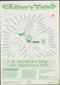
Document - WES HARRY COLLECTION: KILLIAN'S TALK, ISSUE TO PROMOTE ST PATRICK'S DAY 17 MARCH 1993, COST ONE DOLLAR
A4 isssue of Killian's Talk, incorportaing Bendigo Irish Associations Newsletter, issue details the activities planned to celebrate St Patrick's Day 17 March 1993. Loose leaf iisueThe TERRACE Print Service, 133 McCrae Street, Bendigo -
Bendigo Historical Society Inc.
Document - BROCHURE 57 FOREST STREET, BENDIGO - ILLIRA
Coloure brochure for real eastate agents McKean McGregor and First National featuring 57 Forest Street, Bendigo. Photos of the exterior and interior plus floor plan. The name of the house ''Illira''buildings, house, illira -
 Bendigo Historical Society Inc.
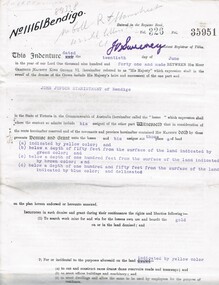
Document - MCCOLL, RANKIN AND STANISTREET COLLECTION: EAST CLARENCE GOLD MINING CO - LEASE 11161, 1941
Document; East Clarence Gold Mining Co - Lease 11161. Lease document for Crown Land No. 11161 Bendigo. Includes plan of lease area Whipstick Road Eaglehawk. No. 11161 Bendigo.MCCOLL RANKIN & STANISTREETorganization, business, gold mining lease, mccoll rankin & stanistreet -
 Bendigo Historical Society Inc.
Document - BILL ASHMAN COLLECTION: CORRESPONDENCE
Two plans of Gifford's Mt Gambier Hotel (one has typed capacities, the other hand written) and one page of typed Particulars of Mr. Gifford's Hotel Boiler for Hot Water.sciences, instruments - general, scalebuoy, bill ashman collection - correspondence, gifford's mt gambier hotel -
Port Melbourne Historical & Preservation Society
Map - MMBW, c. 1894
Melbourne and Metropolitan Board of Works 1894, Plan number 18 Segments Shown: Between 322 - 486 Smaller scale map incorporating piers, lagoon and town north to beyond boundaryIn pencil: "7/7/94" (Which is the copywrite date)engineering - board of works, piers and wharves - railway pier, piers and wharves - town pier, sandridge lagoon, transport - tramways, transport - railways, gasworks, built environment -
 Bendigo Historical Society Inc.
Document - MCCOLL, RANKIN AND STANISTREET COLLECTION: INDENTURE NO. 10834 BENDIGO, 1936
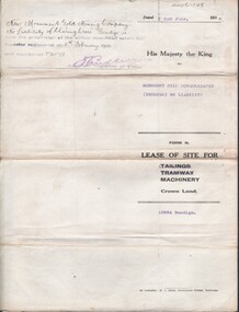
Document: Monument Hill consolidated (Bendigo) N/L. 10834 lease of site for machinery 2/6/1936. Plan included. A. Phillips------- 4/25207. Signature Asst. Registrar of titles.MCCOLL RANKIN & STANISTREETorganization, business, gold mining lease, mccoll rankin & stanistreet -
 Bendigo Historical Society Inc.
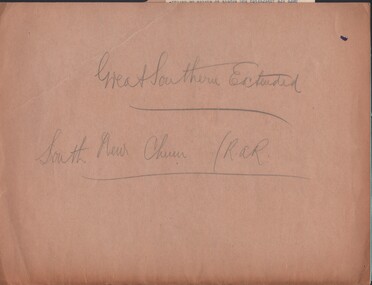
Document - MCCOLL, RANKIN AND STANISTREET COLLECTION: GREAT SOUTHERN EXTENDED, 1934
Documents: folder contains - plan of area applied for on Lease No. 10486 - 1934, 1933 application for mining lease, 1934 application for mining lease. Great Southern Extended and South New Chum.MCCOLL RANKIN AND STANSISTREETorganization, business, gold mining - legal, mccoll rankin and stansistreet, great southern extended, new chum line. -
 Bendigo Historical Society Inc.
Newspaper - HARRY BIGGS COLLECTION: HISTORY OF BOORT & DISTRICT, 1964
Newspaper. Harry Biggs Collection. Old newspaper cuttings relating to the history of Boort and district, including the formation of the Boort Historical Society. Contributions being sought for planned book on the history of Boort.newspaper, harry biggs collection, boort, boort historical society -
 Bendigo Historical Society Inc.
Map - JACK FLYNN COLLECTION: HUNTLY, 12.03.1932
Map: Township of Huntly, Parish of Huntly , County of Bendigo. Parish plan. Western and South Riding Division on Main St. (Main Northern Highway) - written in ink below name of map.BY Authority H.J. Green. Photo-Lithographed at the Dept., of Lands and Survey, Melbourne. 12.3.32map, bendigo, township, huntly -
NMIT (Northern Melbourne Institute of TAFE)
Report: Campuses, buildings and rooms - Layouts and listings July 1994 NMCOT
Spiral bound report of 284 pages, A4 size. Consists mainly of campus location maps and room layout plans by building. Prepared by Neville Lester for Northern Metropolitan College of TAFE.northern metropolitan college of tafe, buildings, reports, nmit -
Bendigo Historical Society Inc.
Map - HUNTLY, SHEET 4, 29/03/1876
Map: Parish of Huntly, Sheet 4, County of Bendigo. Hand Draughted Parish plan. Originally in Map Cupboard. Relocated to Map Drawer 5 on 22.9.22. Too long for the map cupboard.map, bendigo, parish plan, huntly -
Bendigo Historical Society Inc.
Map - PLAN OF THE BENDIGO RAILWAY YARD, Circa 1960
Map: Plan of the Bendigo Railway Yards, Scale: 80 feet to 1 inch. 1960's. (number 319 in map cupboard 1) Location unknown. Image in Mosaic images overflow.map, bendigo, railway yard, railways, rail yards, station layout -
Lakes Entrance Regional Historical Society (operating as Lakes Entrance History Centre & Museum)
Book, Coates Rhonda B, Searching for the Man from Snowy River
A lively account of the planning,construction,and celebration of the bridge over the Snowy River at Deddick, previously the major river crossing between the Monaro and East Gippsland, first by foot or horseback then ferry or punts.bridges, waterways