Showing 4572 items
matching park street
-
 Kew Historical Society Inc
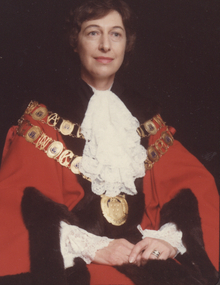
Photograph - Cr Jill O'Brien, Mayor of Kew 1983-84, 1983
Born in Bendigo and trained as a nurse in the 1950s, Sonia Jill O’Brien devoted a lifetime to social and environmental issues at both the state and local level. From her work in the 1960s with the Family Planning Association of Victoria, of which she was a founding member, through to the 1990s as a member of the Ethics Committee of the Department of Health, she supported efforts to improve women’s health and reproductive rights. At the local level she was most active on committees that worked to save the natural and built environment. The Power-line Action Group, the Studley Park Conservation Society, and the Yarra Bend Park Trust all benefitted from her indefatigable endeavours as well her vision. In 1980, Jill O’Brien successfully stood for the Kew City Council and served as Mayor in 1983 and 1984. With an eye to preserving the past as well as guarding the future, she had the Mayoral robes restored and in 1980 and 1981 was president of the Kew Historical Society. The preservation and restoration of Villa Alba in Walmer Street owes much to her determined efforts throughout the 1980s. On Council, she chaired a number of committees involved in the saving of the Kew River Parklands from the proposed transmission line of the SEC. To this end, she was the Council representative on the Merri Yarra Municipal Protection Committee.Rare colour photograph, used as the official mayoral portrait of Cr Jill O'Brien.Formal civic portrait of Cr Jill O'Brien in red mayoral robes wearing lace jabot and cuffs. The portrait is part of the larger Jill O'Brien Collection donated by her daughters.cr jill o'brien, city of kew -- mayors, mayoral portraits -- city of kew -
 Kew Historical Society Inc
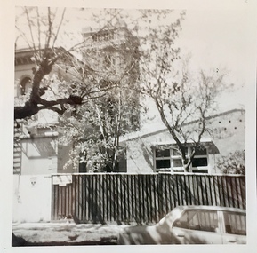
Photograph - 'Villa Alba', 44 Walmer Street, 1981
Villa Alba, a two-storeyed residence with rendered masonry walls and a slate roof, stands opposite Studley Park, overlooking the Yarra River. It is believed to have been first built before 1863, but substantially remodelled and enlarged in about 1882-83 for William Greenlaw, the Manager of the Colonial Bank of Australasia. Although the house and its tower must always have been a landmark in the area and the architecture is unusual, almost Norman in style, it is the interior which is the most remarkable feature of Villa Alba. (Source: VHD)Small black and white photographic positive of Vila Alba, 44 Walmer Street, Kew in 1981 when the original 1880s house was surrounded by hospital wards. The latter had been built by the Royal Women's Hospital after it acquired the site in 1950. The site wa Slater transferred to the Mount Royal Hospital before being purchased and converted into a museum of interior design.Verso: "Villa Alba 1981"villa alba -- 44 walmer street -- kew (vic.), mount royal hospital, henry pride wing -
 Kew Historical Society Inc
Photograph - Yarra Valley Floods: Kew East, 1916
Flooding of the Yarra Valley, including that section of the Yarra bordering Kew and Kew East in the north and west of the municipality, was a regular occurrence. Extreme flood events of the Yarra River are recorded to have occurred in 1891, 1901, 1916, 1923 and 1934. The Municipality of Kew's response to these floods was to enact planning decisions restricting residential development in flood prone areas following the floods of 1916, 1921 and 1934. While floods continued after the development of the Upper Yarra Reservoir (construction 1948-57), the regularity and extent of these inundations diminished. During the nineteenth century, the land abutting the south side of the Yarra in Kew was devoted to dairy farming. In the twentieth century, before and after the construction of the Eastern Freeway, much of this low-lying area was used as golf courses and public parks.One of a collection of photographs of flooding in the Kew section of the Yarra Valley which are in important research resource for the location and extent of flooding in the first half of the twentieth century. Flooding of the Yarra Valley at East Kew in 1916. The view is taken from the intersection of Kilby Road with what is believed to be Birdwood Street, looking across the flood waters to Ivanhoe. The extensive flooded area shown in the photograph would have included the Kew Golf Club. Verso: "Floods along Kilby Road / near Birdwood St? & Kilby Road / 1917? / 87yarra river, yarra valley, floods -- kew, kilby road -- kew (vic.), kew golf club -
 Kew Historical Society Inc
Photograph - Yarra Valley Floods: Kew East, 1916
Flooding of the Yarra Valley, including that section of the Yarra bordering Kew and Kew East in the north and west of the municipality, was a regular occurrence. Extreme flood events of the Yarra River are recorded to have occurred in 1891, 1901, 1916, 1923 and 1934. The Municipality of Kew's response to these floods was to enact planning decisions restricting residential development in flood prone areas following the floods of 1916, 1921 and 1934. While floods continued after the development of the Upper Yarra Reservoir (construction 1948-57), the regularity and extent of these inundations diminished. During the nineteenth century, the land abutting the south side of the Yarra in Kew was devoted to dairy farming. In the twentieth century, before and after the construction of the Eastern Freeway, much of this low-lying area was used as golf courses and public parks.One of a collection of photographs of flooding in the Kew section of the Yarra Valley which are in important research resource for the location and extent of flooding in the first half of the twentieth century. Flooding of the Yarra Valley at East Kew in 1916. The view is taken from a street (maybe Birdwood Avenue) intersecting with Kilby Road looking northeast across the flood waters to Ivanhoe and Heidelberg. The extensive flooded area shown in the photograph would have included remnant dairy farms and the Kew Golf Club. Verso: "Floods / Yarra River / East Kew / Kilby Road / 1917? / 87"yarra river, yarra valley, floods -- kew, kilby road -- kew (vic.), kew golf club -
 Kew Historical Society Inc
Photograph - Civic event in Stradbroke Park, 1976
Stradbroke Park. Extent: Kilby Road to Harp Road at Burke Road. Historical Documentation: 1851 - Portion 91 purchased by Edward Glynn; 1888 - The Harp of Erin Estate (which included Section 91) offered for sale; 1896 - The area now known as Stradbroke Park was bisected by a creek that flowed from the Yarra via Hay's Paddock (q.v.) and extended through to Burke Road; 1943 - W.D. Birrell, Town Clerk of Kew, proposed that the creek be filled and a reserve created; 1954 - Entire area designated as 'open space' and named 'Stradbroke Park'. The line of the creek that ran through the Park created a further reserve on the north side of High Street, now known as 'Harrison Reserve'. Existing Condition: The park is largely of mown grass that has mature trees set into it It is possible that a number of these are remnant of the original vegetation, while there are also a number of exotic trees introduced, particularly at the northern end of the park. The southern end is dominated by playing fields. (Source: Sanderson, P 1988. Kew Conservation Study)Colour photographic positive (with colour degradation) of sporting teams at a civic event in Stradbroke Park in Kew East in May 1976. The event was officiated by the Mayor of Kew, Cr Alan Hutchinson. Sporting teams in uniform included: footballers, athletes, cricketers, hockey players. Stradbroke Park is situated on the western boundary of Kew at Burke and Harp Roads.stradbroke park, cr alan hutchinson, team sports -- kew (vic.) -
 Kew Historical Society Inc
Photograph - Civic event in Stradbroke Park, 1976
Stradbroke Park. Extent: Kilby Road to Harp Road at Burke Road. Historical Documentation: 1851 - Portion 91 purchased by Edward Glynn; 1888 - The Harp of Erin Estate (which included Section 91) offered for sale; 1896 - The area now known as Stradbroke Park was bisected by a creek that flowed from the Yarra via Hay's Paddock (q.v.) and extended through to Burke Road; 1943 - W.D. Birrell, Town Clerk of Kew, proposed that the creek be filled and a reserve created; 1954 - Entire area designated as 'open space' and named 'Stradbroke Park'. The line of the creek that ran through the Park created a further reserve on the north side of High Street, now known as 'Harrison Reserve'. Existing Condition: The park is largely of mown grass that has mature trees set into it It is possible that a number of these are remnant of the original vegetation, while there are also a number of exotic trees introduced, particularly at the northern end of the park. The southern end is dominated by playing fields. (Source: Sanderson, P 1988. Kew Conservation Study)Colour photographic positive (with colour degradation) of sporting teams at a civic event in Stradbroke Park in Kew East in May 1976. The event was officiated by the Mayor of Kew, Cr Alan Hutchinson. Stradbroke Park is situated on the western boundary of Kew and bordered by Burke and Harp Roads.stradbroke park, cr alan hutchinson, team sports -- kew (vic.) -
 Kew Historical Society Inc
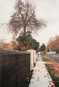
Photograph - Carson Street, Kew, 1993
A series of five photographs of streetscapes in Kew in 1993, of which this is one, focus on footpaths and gutters, so while the provenance is uncertain, it is presumed that they were created in the office of City Engineer in the City of Kew.Colour positive print of Carson Street, which runs between Studley Park Road and Findon Crescent, dating from 1993carson street -- kew (vic.) -
 Kew Historical Society Inc
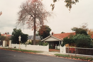
Photograph - Carson Street, Kew, 1993
... 1993. Carson Street runs between Studley Park Road and Findon... from 1993. Carson Street runs between Studley Park Road ...A series of five photographs of streetscapes in Kew in 1993, of which this is one, focus on footpaths and gutters, so while the provenance is uncertain, it is presumed that they were created in the office of City Engineer in the City of Kew.Colour positive print of Carson Street in Kew, dating from 1993. Carson Street runs between Studley Park Road and Findon Crescent.carson street -- kew (vic.) -
 Kew Historical Society Inc
Photograph - The Boulevard at Kew, 1937
The Yarra Scenic Boulevard stretching from Hawthorn to the Chandler Highway was completed as a major project between 1933 and 1936 during a period of significant unemployment. Key dates in the construction this section the road include: 1933 when Kew Council supported the construction of the road from Studley Park to the Kew Asylum; and 1936 when the road from the Johnston Street Bridge to the Chandler Highway was opened. The inscription on the reverse of the photo 'Boulevard Fairfield' is misleading as there is no section of the Boulevard in Fairfield. A more likely interpretation is that it is a photograph of the Kew section of the Yarra Boulevard with the factories of Fairfield in the distance.Rare early photograph of the Yarra Boulevard, taken one year after the opening of the road. The photograph is an important historical record of the results of 'Susso' labor in the creation of major works in Melbourne by the Victorian Government. Original, black and white positive print of the Boulevard at Kew in 1937. Key aspects to note about the photograph is that the road is bituminised; that the gutters are concreted; that the kerb is constructed of concrete blocks; and that there is an unmade footpath on what appears to be the right hand side of the road. The landscape is sparsely treed, and those trees that remain are presumably remnant vegetation. At the right, the land is fenced. The land at the left falls away sharply to the river below. On the horizon, at left, there is an industrial complex including a tall chimney that is burning fuel creating smoke. "Boulevard Fairfield" great depression, susso projects, roads -- kew (vic.), yarra boulevard, yarra valley -
 Kew Historical Society Inc
Photograph - The Race at Dight's Falls, 1925
Dight’s Falls in Studley Park is an artificial weir built on a natural rock bar across the Yarra. The weir was built in the 1840s to provide water to the ‘Ceres’ flour-mill, one of the first in Victoria. The falls were later to become known as Dight’s Falls after the owners of the mill. Later, a pumping station was built on the Kew side of the river, which pumped water uphill to a reservoir in Walmer Street that provided water to the Melbourne Botanical Gardens and to Albert Park Lake. The area around Dight’s Falls was and is frequently used for recreational activities.Original, black and white positive of water flowing over the 'Race' at Dight's Falls in MelbourneInscribed verso: "The Race at Dight's Falls / River Yarra Melbourne / 1.3.25" "Kodak Print"dight's falls, river yarra, yarra -- kew (vic.) -
 Kew Historical Society Inc
Photograph - Flooding of the Yarra Valley at Kew East, 1974
Flooding of the Yarra Valley, including that section of the Yarra bordering Kew and Kew East in the north and west of the municipality, was a regular occurrence. Extreme flood events of the Yarra River are recorded to have occurred in 1891, 1901, 1916, 1923 and 1934. The Municipality of Kew's response to these floods was to enact planning decisions restricting residential development in flood prone areas following the floods of 1916, 1921 and 1934. While floods continued after the development of the Upper Yarra Reservoir (construction 1948-57), the regularity and extent of these inundations diminished. During the nineteenth century, the land abutting the south side of the Yarra in Kew was devoted to dairy farming. In the twentieth century, before and after the construction of the Eastern Freeway, much of this low-lying area was used as golf courses and public parks.Late example of the capacity of the Yarra Valley at Kew to flood, even though drainage works and the Upper Yarra Reservoir had reduced their regularity.Original black and white print photograph of the low-lying land at East Kew under floodwater on 16 May 1974. The vantage point of the photographer is Lister Street. In the photo, the fences of the Kilby Farm can be seen. Flooding was caused by overflowing water in Glass' Creek and the River Yarra. Annotation verso: "Hay's Paddock op No.30 Lister Street / 16 May 1974 11.50am / R.L. 46.04"hays paddock, floods, yarra river, glass' creek, lister street -
 Kew Historical Society Inc
Photograph - Flooding of the Yarra Valley at Kew East, 1974
Flooding of the Yarra Valley, including that section of the Yarra bordering Kew and Kew East in the north and west of the municipality, was a regular occurrence. Extreme flood events of the Yarra River are recorded to have occurred in 1891, 1901, 1916, 1923 and 1934. The Municipality of Kew's response to these floods was to enact planning decisions restricting residential development in flood prone areas following the floods of 1916, 1921 and 1934. While floods continued after the development of the Upper Yarra Reservoir (construction 1948-57), the regularity and extent of these inundations diminished. During the nineteenth century, the land abutting the south side of the Yarra in Kew was devoted to dairy farming. In the twentieth century, before and after the construction of the Eastern Freeway, much of this low-lying area was used as golf courses and public parks.Late example of the capacity of the Yarra Valley at Kew to flood, even though drainage works and the Upper Yarra Reservoir had reduced their regularity.Original black and white print photograph of the low-lying land at East Kew under floodwater on 16 May 1974. The vantage point of the photographer is Lister Street. Flooding was caused by overflowing water in Glass' Creek and the River Yarra. Annotation verso: "Lister Street looking north / Flood level / 16 May 1974 11.30am / R.L. 46.04"hays paddock, floods, yarra river, glass' creek, lister street -
 Kew Historical Society Inc
Photograph - Flooding of the Yarra Valley at Kew East, 1974
Flooding of the Yarra Valley, including that section of the Yarra bordering Kew and Kew East in the north and west of the municipality, was a regular occurrence. Extreme flood events of the Yarra River are recorded to have occurred in 1891, 1901, 1916, 1923 and 1934. The Municipality of Kew's response to these floods was to enact planning decisions restricting residential development in flood prone areas following the floods of 1916, 1921 and 1934. While floods continued after the development of the Upper Yarra Reservoir (construction 1948-57), the regularity and extent of these inundations diminished. During the nineteenth century, the land abutting the south side of the Yarra in Kew was devoted to dairy farming. In the twentieth century, before and after the construction of the Eastern Freeway, much of this low-lying area was used as golf courses and public parks.Late example of the capacity of the Yarra Valley at Kew to flood, even though drainage works and the Upper Yarra Reservoir had reduced their regularity.Original black and white print photograph of the low-lying land at East Kew under floodwater on 16 May 1974. The vantage point of the photographer is Lister Street. Flooding was caused by overflowing water in Glass' Creek and the River Yarra. Annotation verso: "Lister St looking same as No.3 / 16 May 1974 11.30"floods, yarra river, glass' creek, lister street -
 Kew Historical Society Inc
Photograph - In the 'Alexandra Gardens', Kew, 1927
The Alexandra Gardens in Cotham Road, Kew were opened by the Governor of Victoria in 1910. The first curator of the gardens was George Pockett, who with his brother is credited with the layout of the gardens. The gardens were constructed on land originally owned by the King family of 'Madford' in Wellington Street. The land on which the gardens were developed was originally the back paddock of 'Madford' which was purchased by the Borough of Kew in 1906.A rare and early photograph of the gardens showing clearly the changes to the layout and planting during the 1920s. Small, sepia coloured photographic positive of a woman standing beside a path and bridge in the Alexandra Gardens in Cotham Road, Kew.Annotation verso: "Alexandra Gardens Kew 1927"parks and gardens -- kew (vic.), alexandra gardens -- kew (vic.), george pockett -
 Kew Historical Society Inc
Photograph - In the 'Alexandra Gardens', Kew, 1927
The Alexandra Gardens in Cotham Road, Kew were opened by the Governor of Victoria in 1910. The first curator of the gardens was George Pockett, who with his brother is credited with the layout of the gardens. The gardens were constructed on land originally owned by the King family of 'Madford' in Wellington Street. The land on which the gardens were developed was originally the back paddock of 'Madford' which was purchased by the Borough of Kew in 1906.A rare and early photograph of the gardens showing clearly the changes to the layout and planting during the 1920s. Small, sepia coloured photographic positive of a woman with a suitcase standing on a gravel path in front of a semi-circular garden bed in the Alexandra Gardens in Cotham Road, Kew. The main plantings in the rock-bordered bed are varieties of palms. A wooden bridge can be seen to the woman's leftAnnotation verso: "Alexandra Gardens Kew 1927"parks and gardens -- kew (vic.), alexandra gardens -- kew (vic.), george pockett -
 Kew Historical Society Inc
Photograph - In the 'Alexandra Gardens', Kew, 1927
The Alexandra Gardens in Cotham Road, Kew were opened by the Governor of Victoria in 1910. The first curator of the gardens was George Pockett, who with his brother is credited with the layout of the gardens. The gardens were constructed on land originally owned by the King family of 'Madford' in Wellington Street. The land on which the gardens were developed was originally the back paddock of 'Madford' which was purchased by the Borough of Kew in 1906.A rare and early photograph of the gardens showing clearly the changes to the layout and planting during the 1920s. Small, sepia coloured photographic positive of a woman standing on the grass in front of a garden bed in the Alexandra Gardens in Cotham Road, Kew. The Centennial Rotunda, built in 1910, can be seen in the background. Annotation verso: "Alexandra Gardens Kew 1927"parks and gardens -- kew (vic.), alexandra gardens -- kew (vic.), george pockett -
 Expression Australia
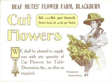
Advertising Card, Cut Flowers - Deaf Mutes' Flower Farm, Blackburn
The Australian Deaf and Dumb Society of Victoria purchased and developed land at Blackburn Lake as a flower farm, the idea being to provide light occupation for the deaf and dumb unable to follow other regular employment, A home for aged and infirm deaf was also erected on the property.A rare example of advertising produced by the Adult Deaf and Dumb Society of Victoria for its Flower Farm at BlackburnSize 15.5cmHx21cmWlake park, blackburn, flower farm, deaf -
 Expression Australia
Advertising Booklet, Lake Park Blackburn - The Idael Place for Pic-Nics
The Australian Deaf and Dumb Society of Victoria purchased and developed land at Blackburn Lake as a flower farm, the idea being to provide light occupation for the deaf and dumb unable to follow other regular employment, A home for aged and infirm deaf was also erected on the property.A rare booklet advertising Lake Park Blackburn as an ideal public picnic spot.Size 12cmHx15cmW; 12 pages -
 Expression Australia
Photograph - c 1900s, The "Power House" on the Lake
An early colour photograph of the pumping station at Blackburn Lake which drew water from the lake for the Lake Park Flower Farm run by the Adult Deaf and Dumb Society of Victoria.This is significant as an early photograph of the pumping station at Blackburn Lake.Colour photograph, 25cmHx22cmWblackburn lake, lake park flower farm, pumping station -
 Queen Victoria Women's Centre
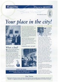
Newsletter, Q Magazine: Yor place in the city!, c. July 1998
Notice of the appointment of a new chair to the Trust, Jan Parkes. A4 Printer paper. 8 pages. Navy and taupe on white. Grey scaled images throughout.governance, cultural structures and establishments, newsletter -
 Queen Victoria Women's Centre
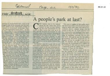
Newspaper Clipping, The Age, A people's park at last?, 13 March 1996
... Queen Victoria Women's Centre 210 Lonsdale Street Melbourne ...news paper clipping. The Age newspaper from page A11'Editorial Page A11. 13/13/96"parks and reserves, hospital, greek community, people in political roles -
 Surrey Hills Historical Society Collection
Domestic object - Milk Bottle, Wattle Park Dairy milk bottle
... was centralised. goodwood street horrie breeden wattle park dairy dairies ...The Breeden family came to Surrey Hills in 1905, first to Guildford Road, then Middlesex Road where Horrie Breeden lived as a boy. He sometimes used to help with milking at the adjoining Kenneally's dairy in Highfield Road. Sometimes he and his brother drove the cows from there to Schneider's property near Florence Road on the way to Surrey Hills Primary School. The cows would graze here until the boys took them back after school. At other times he would deliver milk from the Croydon Road dairy (Isherwood's or Bovill's) to St Joseph's Boys Home before school. Horrie became an apprentice in woodwork / carpentry at Vine's timber yard before serving in World War 1. Horrie's father died in 1919 and in the same year he bought 3 cows and established his own dairy on his mother's property on the corner of Goodwood Street and Boisdale Road. In the 1920s Horrie built the first house in Goodwood Street. He went on to build others in the street including his own at No 7 Goodwood Street. He did all the joinery and internal fittings for this. [Oral testimony: Horrie Breeden to Jocelyn Hall in 1979.] In the first half of the 20th century there were many local dairies in Surrey Hills and Mont Albert. Milk bottles such as this one that include the name of the producer or retailer are historically significant as they represent the period in Surrey Hills' history before milk production was centralised. A glass milk bottle of the style typical between the 1920s and 1940s. Embossed around base: "ONE PINT IMPERIAL". Has a heavy lip on top. the bottle was designed to be sealed with a circular cardboard wad. In red enamel: "PLEASE RETURN TO / Wattle Park / Dairy / WX.1549"goodwood street, horrie breeden, wattle park dairy, dairies, horace breeden -
 Surrey Hills Historical Society Collection
Photograph, Back Creek (later South Surrey Park), c 1936, 1936
This photo was taken at the opening of the footbridge by Sir Winston Dugan in 1936.South Surrey Park was developed on land which had been the property of the Kleinert family. Their land extended from Union Road to Essex Road. They ran horses, ducks and fowls and Emily Kleinert grew flowers. Alan Holt research: Lot 6 was sold to Martin Klienert by Karl Richter in 1860 together with a portion of another adjacent lot. From 1860-1885 Martin worked it as a market garden leasing some land for grazing when it was not required for gardening. He died in 1898. In a formal document, William declared he was the son of Martin "who purchased land in 1860, died in 1898 and the land has been continually occupied by father and family since. It has been cultivated as a market garden; when not being used for gardening it was let for cultivation and grazing." William died in 1939 and the property passed to his sons Martin and Ernest. The family sold the land to the Camberwell Council in the 1950s.This photo is significant as it shows the transition from rural to urban land use in Surrey Hills.Black and white photo taken in the area later known as South Surrey Park. Back Creek is in the foreground. There is a tent on the LHS and approximately 7 houses which front Verdun Street. Some of their backyards face onto the open space along the creek bed.parks and reserves, creeks, south surrey park, civic occasion, official events, back creek, verdun street, 1936, kleinert family, sir winston dugan, topography -
 Surrey Hills Historical Society Collection
Photograph, Opening of the footbridge across Back Creek, 1936, 1936
This photo was taken at the opening of the footbridge over Back Creek by Sir Winston Dugan, Governor of Victoria, in 1936. He is cutting bunting draped along the bridge rails. South Surrey Park was developed on land which had been the property of the Kleinert family. Their land extended from Union Road to Essex Road. They ran horses, ducks and fowls and Emily Kleinert grew flowers. Alan Holt research: Lot 6 was sold to Martin Klienert by Karl Richter in 1860 together with a portion of another adjacent lot. From 1860-1885 Martin worked it as a market garden leasing some land for grazing when it was not required for gardening. He died in 1898. In a formal document, William declared he was the son of Martin "who purchased land in 1860, died in 1898 and the land has been continually occupied by father and family since. It has been cultivated as a market garden; when not being used for gardening it was let for cultivation and grazing." William died in 1939 and the property passed to his sons Martin and Ernest. The family sold the land to the Camberwell Council in the 1950s.This photo is significant as it documents the change from rural to urban land use in the area.Black and white photo taken at the opening of the footbridge across Back Creek in the area later known as South Surrey Park. Back Creek runs diagonally through the photo with a wooden footbridge prominent. Dignitaries are gathered on the bridge. A tent and houses can just be distinguished in the background.parks and reserves, creeks, south surrey park, civic occasion, official events, back creek, verdun street, footbridges, governor of victoria, sir winston duggan, surrey hills, kleinert family, (mr) karl richter, (mr) martin kleinert, topography -
 Brimbank City Council Art Collection
Painting, United Transport Fire, 1989
Social realism pertaining to the Western SuburbsView of United Transport Fire from Moreland Street Studio. More people viewed the fire than showed up for the Footscray parade a fews earlier. The Mr Whippy van made an economical killing, while the atmosphere was suffering the same results. AR0099social realism, western suburbs -
 Brimbank City Council Art Collection
Photograph, Robert Pointon, From Essendon looking west over the Maribyrnong River towards Duke Street Quarries Essendon, early 1990s
Local SceneFrom Essendon looking west over the Maribyrnong River towards Duke Street Quarries Essendon - AR0017 -
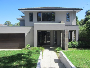 Surrey Hills Historical Society Collection
Photograph - 31 Park Road, Surrey Hills, On The Street Where You Live Project
Photos documenting this address as part of a photographic series undertaken by volunteer photographers during 2013 and 2014 for The Street Where You Live Project. This was organised through the Surrey Hills Neighbourhood Centre and covered the postcode 3127 in the cities of Boroondara and Whitehorse.These photos provide a snapshot of real estate in the suburbs of Mont Albert and Surrey Hills during a period of rapid change with many properties on large blocks demolished to create higher density residential development or renewal of single dwellings. At particular risk were properties not covered by heritage overlays, especially interwar housing and post 1950's housing. -
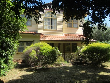 Surrey Hills Historical Society Collection
Photograph - 33 Park Road, Surrey Hills, On The Street Where You Live Project
Photos documenting this address as part of a photographic series undertaken by volunteer photographers during 2013 and 2014 for The Street Where You Live Project. This was organised through the Surrey Hills Neighbourhood Centre and covered the postcode 3127 in the cities of Boroondara and Whitehorse.These photos provide a snapshot of real estate in the suburbs of Mont Albert and Surrey Hills during a period of rapid change with many properties on large blocks demolished to create higher density residential development or renewal of single dwellings. At particular risk were properties not covered by heritage overlays, especially interwar housing and post 1950's housing. -
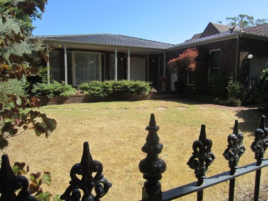 Surrey Hills Historical Society Collection
Photograph - 35 Park Road, Surrey Hills, On The Street Where You Live Project
Photos documenting this address as part of a photographic series undertaken by volunteer photographers during 2013 and 2014 for The Street Where You Live Project. This was organised through the Surrey Hills Neighbourhood Centre and covered the postcode 3127 in the cities of Boroondara and Whitehorse.These photos provide a snapshot of real estate in the suburbs of Mont Albert and Surrey Hills during a period of rapid change with many properties on large blocks demolished to create higher density residential development or renewal of single dwellings. At particular risk were properties not covered by heritage overlays, especially interwar housing and post 1950's housing.