Showing 9560 items
matching 19
-
 Port of Echuca
Photograph - Black & white photograph of boats tied up at Morgan Wharf, Boats tied up at Morgan Wharf, 19/09/1984
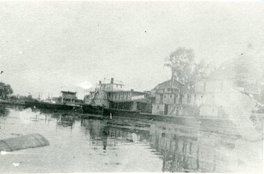
Shows the extent of the River trade in the Murray Darling River basin in the early 20th Century.Helps show the extent of river trade in the Riverland area of South Australia in the early 20th Century.Copy of an original photograph of a wharf scene with moored river boats. possibly of Morgan c. 1900.Written on back in pencil."boats tied up at Morgan-?"murray river, paddle steamers, river boats, morgan. south australia., riverland -
 Port of Echuca
Black and white photograph of the Darling River near Wilcannia, Paddle steamers at Wilcannia On the Darling River. N.S.W, 19/09/1984
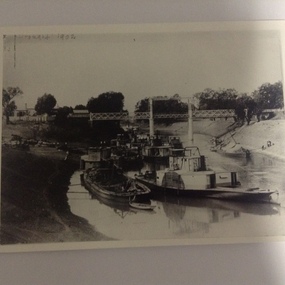
This is a copy of a photograph taken in 1902 to show the extent of the drought on the Darling River. It is taken near the town of Wilcannia and relates to P000012. 8 paddle steamers and 4 barges can be seen. One barge is being unloaded onto the bank. One of the paddle steamers is thought to be the P.S Wandering Jew which was built in Victoria in 1866 (Ref. The Register of Australian and N.Z Shipping' by C. Earnshaw. Page 136)This is a photograph showing the extent of the 1902 drought in the Murray Darling River basin. It also shows the type of cargo and the capacity or the barges. It also shows unloading techniques. Compare this to P000012 which shows the same scene, but with no boats present. A copy of a black and white photograph of boats stranded on the Central Darling River in the 1902 drought. Various paddle steamers and barges are piled along the left bank, including the 'P.S Wandering Jew'. Cargo is being transferred on the bank.The National Library of Australia stamp is on the back. Also written in pencil on the back of the photograph; "Originals copied by Nat. Library from photos donated by H. Coulson. Darling River." On the front of the photograph in the top, left corner in handwriting is written 'Drought 1902.'drought, wilcannia, darling river, paddle steamers, irrigation, p.s wandering jew., barges, 1902 -
 Port of Echuca
Black and white copy of a photograph of steam boats on the Darling River in 1902, Paddle steamers on the Darling River at Wilcannia in 1902, 19/09/1984
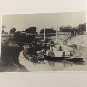
Original photograph held by Helen Coulson. A copy is also held by the National Library. 1902 was a drought year. Compare the water levels with that of the same view in P000012. 'P. S Wandering Jew' was built in Victoria in 1866. ( Ref; "The Register of Australian and N.Z Shipping." By C.Earnshaw. Page 136.This photo is significant because it shows the extent of the 1902 drought. It also shows the type of cargo carried in barges, and also the techniques used to unload the cargo. It also show the difference between stern wheelers and side wheeler paddle steamers. It also shows the length nod the height of the bridge at Wilcannia to cope with high and low water levels.A copy of a black and white photograph taken in 1902. It shows 8 paddle steamers and 4 barges under a bridge over the Darling River near Wilcannia in N.S.W. Cargo is being unloaded onto the left bank. Two barges are also tied up on the right bank.Written on the back in pencil " see photo P000012 and P000014.1drought, 1902, darling river, paddle steamers, barges, cargo, river trade, murray darling river basin, irrigation, wilcannia -
 Port of Echuca
Photograph - Black and white photograph of the P.S Nellie, P.S Nellie, 19/09/1984
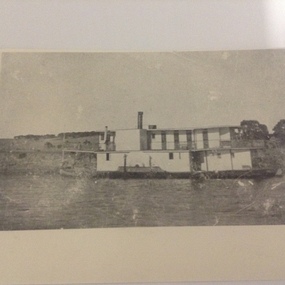
The P.S Nellie was 79.8 feet in length and 20.4 feet in breadth, and depth of 4.6 feet. It weighed 58 tons net and 66 tons gross. It was made of wood and had a capacity of 10 H.P. It was built at Moama in 1882 and was registered in Adelaide in 1882. Its registration number was No. 83,672. The P.S Nellie was owned by the River Murray N. Co. This photograph was taken in 1900. It looks like the P.S Nellie was a passenger paddle steamer, taking passengers up and down the rivers.Not much is known about the P.S. Nellie, but in this photograph it looks like it is a passenger paddle steamer, transporting people up and down the rivers.This is a photo copy of black and white photograph of the P.S Nellie. The photocopy was done in 1984. The original photo was taken in about 1900.Written on the back in lead pencil is "Nellie".paddle steamers, river murray n. co., p.s nellie, boat building at moama, murray river, echuca, passenger vessels -
 Eltham District Historical Society Inc
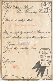
Document - Certificate, The Eltham Barrel Beer Drinking Contest: Awarded to Rex "Young Pommy" Whitworth, 19 July 1974
The Eltham Beer Barrel Drinking Contest This is to certify that Rex "Young Pommy" Whitworth Has successfully downed 10 Grogs, and is still standing to sign this certificate! Signed R. Whitworth Dated this eventful 19th day of July 1974 Manager (signature illegible) Rex, a carpenter, was registered to vote in 1963 and was recorded as living in Storey Avenue, Research. He was still living at the same address in 1980. Given Rex had to be at least 21 years of age in 1963 (to be eligible to vote), that would make him at least 32 in 1974.Rex "Young Pommy" Whitworth signature, date and signature of Managereltham barrel, rex whitworth, certificate, beer drinking contest, award -
 Eltham District Historical Society Inc
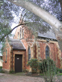
Photograph - Digital Photograph, Marguerite Marshall, Uniting Church, Main Road, Eltham, 19 August 2008
Eltham's original Wesleyan Methodist Church Covered under Heritage Overlay, Nillumbik Planning Scheme. Published: Nillumbik Now and Then / Marguerite Marshall 2008; photographs Alan King with Marguerite Marshall.; p97This collection of almost 130 photos about places and people within the Shire of Nillumbik, an urban and rural municipality in Melbourne's north, contributes to an understanding of the history of the Shire. Published in 2008 immediately prior to the Black Saturday bushfires of February 7, 2009, it documents sites that were impacted, and in some cases destroyed by the fires. It includes photographs taken especially for the publication, creating a unique time capsule representing the Shire in the early 21st century. It remains the most recent comprehenesive publication devoted to the Shire's history connecting local residents to the past. nillumbik now and then (marshall-king) collection -
 Eltham District Historical Society Inc
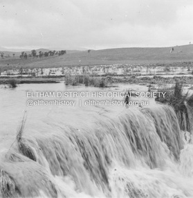
Photograph - Digital Photograph, Marguerite Marshall, Smith Dam, Karingal Drive, Eltham, 19 September 2006
The dam at the entrance to the Nerreman Gateway in Eltham was built according to an internationally acclaimed theory developed by the builder's father. In 1920, Victorian engineer B.A. Smith was awarded the American Society of Civil Engineers J. James R. Cross Gold Medal for his Technical Paper titled 'Arched Dams'. It was the first time this medal had been awarded outside the United States. The concrete arched dam across the Eltham West Drain was built in 1940 by B.A. Smith's son and engineer, D. B. (Bernie) Smith to water the 24 acre (9.75 ha) hobby farm owned by himself and new wife, Isa Smith. Upon completion of the dam a pump-house was constructed beside the creek but before the water could be pumped up the hill they had to dig a trench and lay 500m of 100mm water main to an elevated holding tank. The Smiths made the pump-house their home for several years until they constructed their home at the top of the hill overlooking Eltham and views extending to Kinglake. Following Bernie's death in 1983, Nerreman Park was subdivided between 1993 and 1995. Gordon Ford designed the landscaping and the pump-house was demolished. Covered under Heritage Overlay, Nillumbik Planning Scheme. Published: Nillumbik Now and Then / Marguerite Marshall 2008; photographs Alan King with Marguerite Marshall.; p137This collection of almost 130 photos about places and people within the Shire of Nillumbik, an urban and rural municipality in Melbourne's north, contributes to an understanding of the history of the Shire. Published in 2008 immediately prior to the Black Saturday bushfires of February 7, 2009, it documents sites that were impacted, and in some cases destroyed by the fires. It includes photographs taken especially for the publication, creating a unique time capsule representing the Shire in the early 21st century. It remains the most recent comprehenesive publication devoted to the Shire's history connecting local residents to the past. nillumbik now and then (marshall-king) collection, eltham, karingal drive, smiths dam, bernie smith, gordon ford, isa smith, nerreman gateway, nerreman park estate, dams -
 Eltham District Historical Society Inc
Album - Photograph, J.A. McDonald, Eltham-Yarra Glen Road, 19 Oct. 1956
Dixons Creek Road 19th October, 1956 Scour developing back onto road from Smedley’s property near Blease RoadRecord of various Shire of Eltham infrastructure works undertaken during the period of 1952-1962 involving bridge and road reconstruction projects, sometimes with Eltham Shire Council Project Reference numbers quoted. It was during this period that a number of significant improvements were made to roads and new bridges constructed within the shire that remain in place as of present day (2022). In many situations, the photos provide a tangible visible record of infrastructure that existed throughout the early days of the Shire. The album was put together by or under the direction of the Shire Engineer, J.A. McDonald.infrastructure, road construction, shire of eltham, bridge construction, eltham-yarra glen road, 1956-10-19, dixons creek bridge, dixon's creek road, floods -
 Eltham District Historical Society Inc
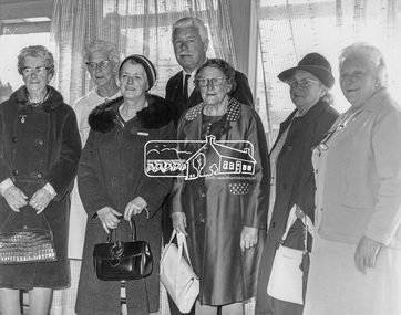
Photograph, His Excellency Major General Sir Rohan Delacombe with Lady members of the Shire of Eltham Elderly Citizens' Clubs, 19 September 1973
The State Governor Sir Rohan Delacombe and Lady Delacombe visited the Shire of Eltham where they were entertained to a civic luncheon by the Shire President Cr. L. E. Clarke and councilors at the Panton Hill hotel and made a tour of the shire. Among which was the Eltham elderly citizens' club where he met L-R: Mrs Lander, Mrs Stevenson, Mrs Armstrong, Mrs Norman, Mrs - , and Mrs Crockett. This photo forms part of a collection of photographs gathered by the Shire of Eltham for their centenary project book,"Pioneers and Painters: 100 years of the Shire of Eltham" by Alan Marshall (1971). The collection of over 500 images is held in partnership between Eltham District Historical Society and Yarra Plenty Regional Library (Eltham Library) and is now formally known as 'The Shire of Eltham Pioneers Photograph Collection.' It is significant in being the first community sourced collection representing the places and people of the Shire's first one hundred years.Digital imagemajor general sir rohan delacombe, mrs armstrong, mrs crockett, mrs lander, mrs norman, mrs stevenson, sepp, shire of eltham pioneers photograph collection, rohan delacombe, governor, visit, crockett, lander, sepp, senior citizens centre, seniors, older people, older women, stevenson, armstrong, shire of eltham pioneers photograph collection -
 Eltham District Historical Society Inc
Photograph, Tess Justine (Nillumbik Shire Council), Murray's Bridge over the Diamond Creek, Eltham North, 19 Feb 2022
Murray's Bridge over the Diamond Creek on the Diamond Creek Trail just prior to demolition and replacement with a new steel bridge. Heritage advice obtained by Nillumbik Shire Council, following a suggestion by the Eltham District Historical Society (EDHS), is that the original bridge appears to have been a simplified version of the Country Roads Board’s (CRB) standard timber bridge design of the early-to-mid 1920s. In c1990 Murray’s bridge was renovated with three recycled steel girders as part of a bike/pedestrian path in the reserve. During these alterations many parts of the bridge were removed, and some were replaced. Heritage advice indicates the condition of Murray’s bridge is poor. The remaining original parts are all in poor condition, with severe weathering, splitting and rot, especially to the stringers retained on the bridge. Heritage advice is that Murray’s Bridge does not have sufficient significance in the cultural history of the Nillumbik area to warrant inclusion in the Nillumbik Shire Heritage Overlay and also does not have sufficient significance as a rare survivor to warrant inclusion in the Nillumbik Shire Heritage Overlay. There are no indications in the historical record that this site was individually important to the cultural history of this area. EDHS is comfortable with the heritage advice provided to Council and has worked closely on this project with Council. EDHS has suggested some of the removed timbers be used in the vicinity of the bridge for landscaping and possibly seating, so as to retain these remnants close to the site of the original bridge, which is the last old timber bridge along the lower reaches of the Diamond Creek. Mary (Sweeney) Murray and John Wright Murray selected 80 acres, Lot C Section 16 and Lot 5 Section 17 Parish of Nillumbik, under an occupation license in 1866. John died in 1867 and freehold was granted to his son John in 1873. The farm was known as ‘Laurel Hill’. John Junior was an Eltham Shire councillor and sometime president from 1887 up until 1897. He added Lot A Section 16 to the farm in ca1888. John and his younger brother James arranged to rent/purchase Lot B Section 17, across Diamond Creek to the west, in ca1900. It appears that John and James farmed separately for a few years, with a new homestead built for James ad family on the high point of Lot B Section 17 in ca1910. John sold off Lot 5 Section 17 in 1912. When John died in 1912 James took over the land on both sides of the Diamond Creek. The old homestead on the west side of the Creek disappeared. A farm bridge over Diamond Creek from this period may have been located close to the northern boundary of the farm. John Langlands, owner of the farm known as ‘Ihurst’ on the west side of Diamond Creek to the south of the Murray’s land, died in 1907. In 1909 his land was then subdivided into 100 lots to become the ‘Glen Park Estate’. Other similar subdivisions of nineteenth century farms around Eltham in this period included the ‘Franktonia (or Beard’s) Estate’ to the northeast and ‘Bonsack’s Estate’ between Eltham and Greensborough. Soon after the opening of the railway extension line from Eltham to Hurstbridge in 1912, Glen Park and nearby residents including James Murray agitated for a railway station or siding to be located half-way between Eltham and Hurstbridge, so that the Glen Park residents who used the railway daily did not have to walk into the Eltham or Hurstbridge stations. Some believed Coleman’s Corner (opposite Edendale Farm) was an appropriate spot for the platform. James Murray was among those who thought the railway should be located on his land, closer to half-way between Eltham and Hurstbridge stations. The Railways Commissioners warned that the locals would have to fund these works themselves. The Glen Park Estate residents initially had difficulty accessing Eltham by road, with only an old low-level bridge over Diamond Creek at the south end of their estate. A new timber trestle bridge across the creek, now on Wattletree Road, was opened in 1915. Road access to the north was gained in 1927 when the new Murray’s Road, which crossed the Murray’s land, was built. Residents continued to agitate for a Glen Park station. By 1926 the Railways Commissioners’ preferred site was on the Murray’s land. They arranged an estimate of cost of a full-length platform. The estimate was too much for the locals, who in 1928 argued unsuccessfully for a shorter and hence cheaper platform. By 1929 Murray had agreed to donate the land, but the locals would still have to fund the works. Murray decided, unilaterally it would appear, to commence work on a timber trestle road bridge over Diamond Creek to link the new Murray Road to the proposed station. Late in 1929 he stopped work on the bridge, for reasons unknown, but started work again and completed the bridge in 1931. There is no further newspaper evidence of the campaign for the Glen Park station until 1939, when Murray and another local, Mr Maxwell, met the Railways Commissioner. The Glen Park locale now included 45 homes on the west side of the creek and 20 on the Eltham side. Most of the residents used the train every day. The Commissioner remained adamant that only a full-length platform could be built for safety reasons. It appears the campaign dissolved at this point. The increasing move to cars may have had an impact. There is no evidence of Murray’s bridge ever being connected to Murray’s Road, or of it having wide use for any purpose by locals. James Murray died in 1947 and the farm was taken over by his son James (Jim). Jim started to sell off parts of the farm in the 1980s, retaining a few acres around the ca1910 homestead and building a new house there. Recreation reserves were established along the creek. In ca1990 Murray’s bridge was renovated with steel girders as part of a bike/pedestrian path in the reserve. The old farmhouse was demolished in ca2014. * * * A theory posted on local community Facebook groups was that the bridge was built in the 1860s and was built to be more robust than was necessary for the movement of cows from one side of the creek to the other. It was suggested the robustness was necessary to support the weight of gold ore being transferred from a mine on Murray’s land to a railway siding near Murrays Bridge (presumably for transfer and processing at Diamond Creek). Perhaps this may have been one of the motivators for Murray, who really knows? Knowing when mining operations ceased on his land and how that fits the overall timeline would be useful but at the time the bridge was built, local gold production was minimal at best. The known facts are: • The railway line came to Eltham in 1902. • The extension of the railway from Eltham to Hurstbridge was constructed in 1912 so no railway line even existed through Murray's property until 1912 and the Victorian Railways maps at the time show no such siding on Murray’s property. • In 1923 a new company was formed in anticipation of the old Diamond Creek Gold Mine being re-opened. The mine had been previously closed and flooded. It was noted in the press at the time that the mine was within a mile of the railway. Nothing really came of this. • Construction of Murrays Bridge was commenced by James Murray in early 1929 in anticipation of a proposed flag station being nominated on his land, but work ceased shortly afterwards. The proposed flag station was commonly referred to as Glen Park as the residents of the Glen Park Estate wanted Option 1, located near them with the platform adjacent to Colemans corner. This was probably never going to fly as it was virtually in eyesight of Eltham station. Allandale Road was the third option, but the Commissioners' preferred option was No. 2 - on Murray's property. • The Railway Commissioners were not going to finance any such station and the works had to be funded by private landowners and residents, hence Murray investing in this himself. • Murray recommenced work two years later and finished his bridge in 1931 but unfortunately for him, the proposed flag station never eventuated. The bluestone siding you reference may well have been built by Murray as part of the proposed station platform. • Up until then, apart from the Main Road bridge, which was washed away in 1924, virtually all local crossings over the Diamond Creek were low lying bridges – Kaylocks Bridge at Brougham Street, Diamond Street bridge, Glen Park Road bridge. It is expected that Murray also had a low-lying bridge to connect his land either side of the creek. These were all washed away or severely damaged multiple times in the 1920s. Lessons were learnt, and Murrays Bridge appears to have been built in accordance with Country Road Board standards of the time. Flood damage was ongoing, and even more recently constructed raised bridges kept getting washed away, e.g., the new Wattle Tree Road bridge in 1958 just months after completion. Murray’s bridge was reinforced with steel some 30 years ago presumably to provide additional floodwater resistance, given the history of bridges disappearing in floodwaters. • In March 1932 it was reported in the Advertiser that there were still some prospectors operating around Eltham North who apart from further scarring the face of the earth over the previous two years had gained significant experience but little gold - hardly a driving factor for constructing a dedicated railway siding and bridge to transfer gold ore. It is far more probable that James Murray was hoping to have the railway station located on his property and invested his money by building the bridge to lead to it as well as a station platform. Had the station eventuated, it may well have driven up the value of his land for subdivision and new housing estates like the Glen Park Estate. That did not eventuate. Whilst the bridge was indeed old (90 years), the core structure being completed in 1931, it had been modified substantially from original and hence had no significant historic value – i.e., it was not a representative example of its type, construction, and age. Given that the bridge was not worthy of saving, the Eltham District Historical Society with Council’s support, and the Eltham Woodworkers group endeavoured to see what suitable sized timbers were salvageable to fabricate a commemorative seat. Unfortunately, the experts at the Woodworkers group were unable to salvage any suitable length/width timbers to fabricate the seat due to the presence of rot. Last remaining wooden trestle bridge on the Diamond Creek Trail just prior to demolition and replacementBorn digital image (27)diamond creek (creek), diamond creek trail, murrays bridge, ‘laurel hill’, john wright murray, mary (sweeney) murra, john murray jnr, james murray, john langlands, ‘ihurst’, ‘glen park estate’, beard's estate, franktonia, bonsack's estate, glen park estate, glen park railway station -
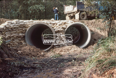
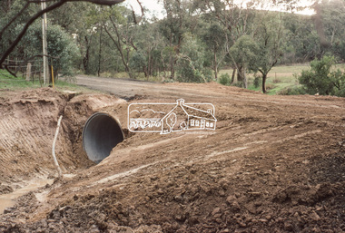
 Eltham District Historical Society Inc
Slide, Culvert construction: Buttermans Track, St Andrews, 19 Jun. 1981
Culvert construction / drainage operations undertaken throughout the Shire of Eltham35 mm colour positive transparency (1 of 2) Mount - Kodak Kodachrome Cardbuttermans track, culvert, infrastructure, roadworks, st andrews -
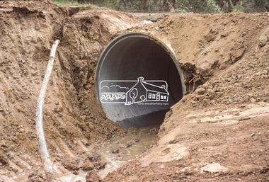
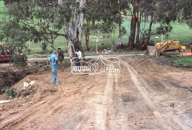
 Eltham District Historical Society Inc
Slide, Culvert construction: Greens Road, Arthurs Creek, 19 Jun. 1981
Culvert construction / drainage operations undertaken throughout the Shire of Eltham - Greens Road near intersection of Cottlesbridge-Strathewen Road, Arthurs Creek35 mm colour positive transparency (1 of 4) Mount - Kodak Kodachrome Cardculvert, infrastructure, roadworks, arthurs creek, cottles bridge-strathewen road, greens road -
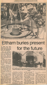 Eltham District Historical Society Inc
Newspaper article, Eltham buries present for the future, 19 November 1985
Article from "Diamond Valley News" with photos relating to the planting of a time capsule by Eltham District Historical Society as part of Victoria's 150th Anniversary celebrations in 1985.harry gilham collection, eltham district historical society, time capsule, 150th anniversary monument -
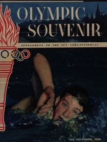 Federation University Historical Collection
Newspaper, Olympic Souvenir, 1956, 19/02/1942
olympic games, mlebourne, john landy, sport -
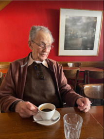 Federation University Historical Collection
Photograph, John Mildren at L’Espresso where he ‘held court’ for many years, 2023, 19/01/2023
John Mildren sits at a table at Ballarat's L'Espresso Cafe.john mildren, staffmember, politician -
 Bendigo Military Museum
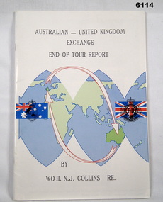
Administrative record - Australian - United Kingdom Exchange End of Tour Report by WO2 NJ Collins RE 1988, WO2 N.J. Collins RE, 19 April 1988
Contains the 1988 End of Tour Report by WO2 NJ Collins RE , a British Army SNCO on a two year exchange at the Army Survey Regiment, Bendigo A4 size, front cover has a world graphic with Australian and UK Flags superimposed. Each flag has relevant Corps Badges superimposed. Inside front cover has photos of parts of Villa Fortuna. Inside back cover has a list of ex-British Military Survey members presently serving with the Royal Australian Survey Corps.Green Highlight on parts of Pages 7,8 and 11royal australian survey corps, rasvy, fortuna, army survey regiment, army svy regt, asr -
 Bendigo Military Museum
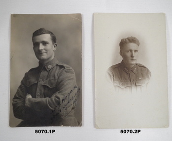
Photograph - PHOTOGRAPHS 38th BN, C. 1918 -19
.1) William James Hogan No 1645 38th Bn, original photo, refer Cat No 1510 for service details. .2) Charles Ernest Newton MM, No 951 enlisted on 25.3.1916 in C Coy 38th Bn age 20 years 3 months, embark for England 20.6.1916, embark for France 22.11.1916, made L/Cpl 4.6.1917, WIA 7.4.1917 Gassed, rejoin unit 22.8.1917, hospital 13.10.1917 with P.U.O then Influenza, rejoin unit 10.1.1918, Made Cpl 17.8.1918, awarded “MM” 26/31st August 1918 near Clery sur Somme, WIA 2nd occasion 2.9.1918 Gas poisoning, rejoin unit 16.1.1919, RTA 22.9.1919, discharged from the AIF 1.2.1920. Refer also 5039.3P.Two photos 1 sepia 1 B & W portraits of soldiers in uniform no hats on. .1) Soldier arms crossed Sgt stripes on arm. .2) Soldier with “MM” ribbon on..1) On rear, “France 8.1.1919, To Tead from Bill, memories of Paris Trip 1918”. On front, “ W.J.Hogan, yours sincerely 9.1.1919”. .2) On rear, “C.E.Newton”.photographs, 38th bn, c coy, mm -
 Bendigo Military Museum
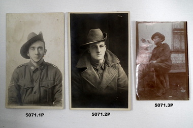
Photograph - PHOTOGRAPHS 38th BN, 1).2) c 1918 - 19, .3) post 1920
All soldiers are believed to be in the 38th Bn AIF not yet identified. .3) the original/negative is held in the Grinton collection. That were all in a collection of photos, records, magazines from the 38th BN reunion Association Melbourne.Three photos 2 B & W portrait no background, 1 sepia with building in background, all rectangular shape, soldiers in uniform. .1) Soldier face with Cpl stripes on arm. .2) Soldier face on wearing a great coat. .3) Soldier sitting side on a log..3) On rear, “Ted M”photographs, 38th bn -
 Bendigo Military Museum
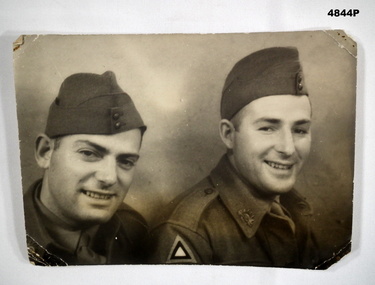
Photograph, 19 June 1940
WW2 Uniformed soldiers.Two uniformed Army Soldiers from 2nd/2nd Pioneer Btn.With fondest love from Jack and Ken, June 17th 1949 - To Grandma, Trixie and Lindsay.photograp, ww2 -
 Federation University Historical Collection
Photograph, Grave of King Billy in the Ballaarat New Cemetery, 19/10/2021
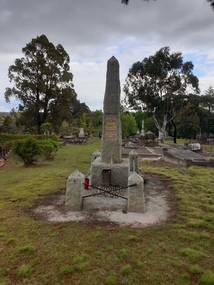
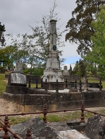
Mullawullah died on 23 September 1896. His funeral on 26 September attracted a large crown. IN 1897 the Australian Natives Association and the Ballarat Municipal COuncil raised money to this gravestone. Photos relating to the grave of King Billy in the Ballaarat New Cemeteryking billy, ballaarat new cemetery, frank wilson, william willson, wadawurrung, mullawullah, aboriginal -
 Federation University Historical Collection
Photograph - Photo, Clare Gervasoni, Grave of Martin Hosking in the Ballaarat New Cemetery, 19/10/2021
The grave was made by F.W. Commons, Balllarat.Photos relating to the grave of Martin Hosking Ballarat missionary.Erected By the Citizens of Ballarat In Affectiontel Remembrance of Martin Hosking Town Missionary Who for 21 Years devoted his life and energy to the cause of the poor and suffering. Died honoured and beloved 17th Feb 1898 Aged 51 years Well done, thugh good and faithfull servant ballaarat new cemetery, martin hosking, f.w. commons -
 Federation University Historical Collection
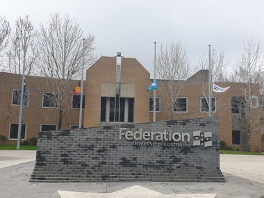
Photograph, Clare Gervasoni, Mount Helen Campus Flags at Half Mast at the TIme of Queen Elizabethh II's Death, 19/09/2022
Mount Helen Campus Flags at Half Mast at the TIme of Queen Elizabethh II's Deathqueen elizabeth ii, death, morning, half mast, flag, federation university mount helen campus, federation wall -
 Federation University Historical Collection
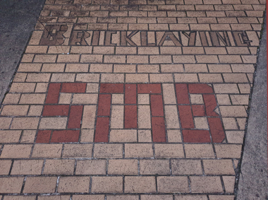
Photograph - Photograph - Colour, Clare Gervasoni, Ballarat School of Mines Bricklaying Building in Yuille Street, Ballarat, 2020, 19/06/2020
The Ballarat School of Mines Bricklaying Department was located at a building in Yuille Street before moving to a custom build facility in Grant StreetThree photographs from the former Ballarat School of Mines Bricklating School in Yuille Street, Ballarat. 1. 'Bricklaying SMB' depicted in brick paving at the front of the building. 2. University of Ballarat Bricklaying sign on the door of the building 3. Brick Building with a School of Mines & Industries Bricklaying Department - sponsored by Selkirk Bricks and Paversbricklaying, ballarat school of mines bricklaying department, buildings, yuille street, selkirk bricks and pavers, building construction -
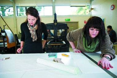 Federation University Historical Collection
Photograph - Digital image, UBlive Production Team, 19/11/2013
Two Visual Arts students in the Printmaking Studio at the Gippsland Centre for Art and Design.arts academy, gippsland centre for art and design, churchill, printmaking, visual arts -
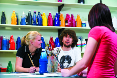 Federation University Historical Collection
Photograph - Digital image, UBlive Production Team, 19/11/2013
Two Visual Arts students in the Printmaking Studio at the Gippsland Centre for Art and Design.arts academy, gippsland centre for art and design, churchill, visual arts -
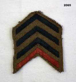 Bendigo Military Museum
Award - CHEVRONS WW1, 1917-19
Chevrons were worn inverted above the wrist on the right arm. The red stripe denotes that the soldier embarked in 1914. The blue stripes are for each year of overseas service. These chevrons were worn by Harold Hall No 270, 10th Batt & 7th Field Ambulance AIF. Refer 2062, 2064, 2065Blue and red Chevrons, cloth, "V" shaped denoting years of service overseas.Nonemilitary, uniform, service, history, chevrons