Showing 7019 items matching "historic"
-
 The Beechworth Burke Museum
Photograph - Post Card, Rose Series Stereograph Co. Postcard
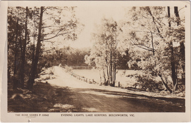
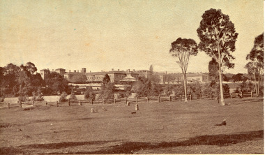
The construction on Lake Kerferd began in 1862 however it wasn't completed until 1874 due to engineering and funding issues. The lake was named after George Briscoe Kerferd (1831–1889) who was responsible for Beechworth's water scheme. George Briscoe Kerferd was born on 21 January 1831 in Liverpool, England and arrived in Melbourne April 1853. He spent his first years in Australia in Bendigo before settling down in Beechworth as a wine and spirits merchant. He married Ann Martindale on 17th December 1853 at St James Cathedral, Melbourne and between them they had three sons and five daughters. Kerferd began his political and legal career in Beechworth when he was first elected to the Municipal Council in May 1857. Later he would be elected to the Legislative Assembly for the Ovens District in November 1864, and continued to represent the area until February 1886. The postcard holds Historic significance due to its connection to Beechworth and its Lake Kerford. It demonstrates the interactions between nature and colonialists, especially how the lake has somewhat been 'protected' with the man made fencing. It also presents information on the environmental development or degradation for the area, with possible changes to the environment that may have been caused by human physical forces, natural decay or Global Warming.Sepia rectangular postcard printed on paper.Obverse: The Rose Series P. 10542 / Copyright / Evening lights, Lake Kerferd, Beechworth, VIC Reverse: Farley / Published by the Rose Stereograph Co., / Armadale Victoria. / 84-132-1 / Post card / The "Rose" Series De Luxe / A Real Photograph Produced in Australia / BMM299 lake kerferd, beechworth, water scheme, water reserve, reservoir, legislative assembly, hon. george briscoe kerferd, catchments, beechworth water reserve, beechworth catchments, municipal council, st. james cathedral, lakes, reserve, water supply, political projects, rose series, postcard, rose series stereograph -
 The Beechworth Burke Museum
Photograph, 1960s
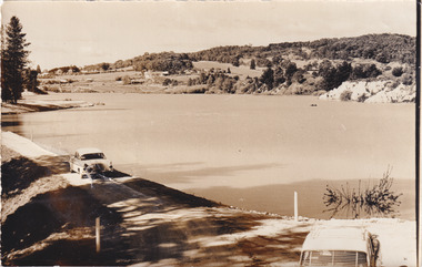
Taken around 1960s, this photograph shows the banks of Lake Sambell. Lake Sambell is named after Mr. L. H. Sambell who was instrumental in the lake's formation. Lake Sambell is the original site of the open sluice operation of Rocky Mountain Mining Company in the 1800s and the early 1900s. In the early 1920s, it was reconstructed as a recreational lake and was formally opened to public on 6 October 1928. The opening event was attended by townspeople and Beechworth's Minister of Lands Mr. Bailey. In the late 1930s to early 1940s, Lake Sambell redeveloped. The first development aimed to raise the banks by six feet to double its present area and to make the water cleaner. Another redevelopment in the 1940s was made possible by the Beechworth and District Progress Association. It involved raising the banks to five feet to provide swimming facilities, paddling pool and caravan park. This photograph holds Historic significance because of its connection to the development of Beechworth district.Sepia rectangular photograph printed on matte photographic paperObverse: Reverse: 3533 /beechworth, water scheme, water reserve, catchments, beechworth water reserve, beechworth catchments, municipal council, lakes, reserve, water supply, political projects, environmental changes, mr. l. h. sambell, sambell, rocky mountain mining company, recreational lake, minister of lands, mr. bailey, swimming pool, paddling pool, caravan park, swimming facilities, lake redevelopment, funding -
 The Beechworth Burke Museum
Photograph, 1960s
This photograph was taken in the 1960s at Lake Sambell Caravan Park, visible in the photograph are individual caravan sites with electricity outlets, a large single-story building, a parked car, and two caravans partially obstructed by trees. Lake Sambell Caravan Park opened in 1959 owing to the work of R.E. Carter, Beechworth Shire engineer from 1954-63. Carter advocated for improvements to the lake and surrounding area in order to encourage tourism in Beechworth. The opening of the caravan park was part of many improvements to Lake Sambell made in this period by Carter including: the swimming pool in 1961, water skiing and boating facilities, and increased lake surface in 1964. These improvements were financed mainly by grants from the Tourist Development Authority. The popularity of caravanning in Australia exploded during this post-war period of the late 1950s and 1960s. This popularity was driven by multiple factors, including: the stopping of fuel rations, the accessibility of car ownership through the manufacturing of affordable cars, technological developments in caravan design, and the increase in prosperity and leisure time for many Australians. Facilities such as electrical outlets to power caravans are present in this photograph of Lake Sambell Caravan Park. Lake Sambell is an artificial lake that was developed on the previous site of the Rocky Mountain Mining Company workings and was officially opened by Minister for Lands, Mr Baily, on October 5, 1928. The disused and unattractive remains of the mine were converted into a recreational area intended for swimming, boating, and fishing. The lake is named after Mr L.H. Sambell, shire engineer and secretary of the Forward Beechworth Committee, who advocated for the enhancement of Beechworth into a tourist destination and was central to the planning and establishment of the lake. This photograph is of historic and social significance in documenting the enhancement of the Lake Sambell area overseen by R.E. Carter and providing insight into caravanning during the 1960s in Australia. Caravanning was extremely popular in Australia during the late 1950s and 60s due to multiple social and economic factors including the stopping of fuel rations, the accessibility of car ownership through the manufacturing of affordable cars, technological developments in caravan design, and the increase in prosperity and leisure time for many Australians. Black and white rectangle photograph printed on photographic paper and unmounted.Reverse: 3538/ [logo back printing KODAK/ VELOX/ PAPER] / C798lake sambell caravan park, lake sambell, lake sambell 1960s, lake sambell fishing, lake sambell boating, lake sambell swimming pool, r.e. carter, l.h. sambell, tourist development authority, caravanning 1960s, caravan electricity outlets, caravan park, forward beechworth committee, rocky mountain mining company, lake caravan park, caravan mid 20th century, beechworth tourism, travel in the 1960s, holiday 1960s -
 The Beechworth Burke Museum
Photograph
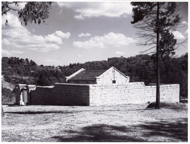
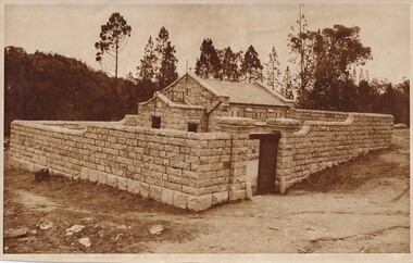
The photograph is of the Powder Magazine and gorge in Beechworth. The Magazine was built for six hundred and ninety-seven pounds in 1859 by "T Dawson and company." However, the walls were constructed later in 1860 by "Atchison and Lumsden," a different building firm. The Beechworth Magazine was one of many made by the government for the storage of gunpowder. However, the building eventually stopped being used as the mining decreased in the area, finally becoming unsused with the invention of nitro-glycerine compounds. The magazine was created to hold large quantities of gunpowder and much of its design was to hinder the prospective of damage. These safety features included double arched foundations and an arched inner roof, which would move a possible explosion upwards. Also, a process of lighting conductors, ventilation and heavy granite walls were incorporated in the designThe photograph shows historic significance due to its association with the mining era in Beechworth in the late 1800s. The photo shows the Powder Magazine after construction, most likely when it was storing gunpowder during a signifiant time period for the region.Black and white photograph printed on paper.beechworth, powder magazine, gunpowder, mining, beechworth powder magazine, explosives, atchison and lumsden, t dawson and company, gorge, granite, granite building, 1860 -
 The Beechworth Burke Museum
Photograph - Postcard, Town Hall Beechworth, c1910
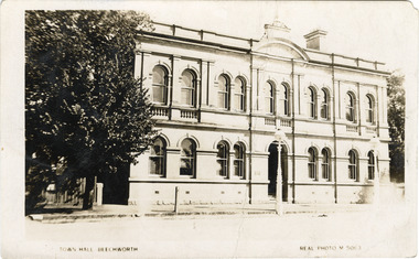
Beechworth Town Hall was designed by architects J.J. Coe and Thomas Dalziel and is dated to 1859. The building was made of granite and constructed to local builders Donald and William Fiddes. The original front to the building was replaced by a two story facade in 1889 designed by George Jobbins and built by Thomas Sandham according to a plaque on the front. The Town Hall is remarkable for its vaulted ceilings and columns. Originally the building was used as the Shire Offices but also doubled as a fire station and a courthouse, with still surviving cells underneath. Among the inmates was notorious bushranger Harry Power who was originally transported to Van Dieman’s Land for stealing a pair of shoes. He gained his freedom six years later but spent time in and out of gaol for the rest of his life for a variety of offences including a number of armed robberies. The Town Hall is now home to the Visitor Information Centre which helps visitors with amongst other things, accommodation, tours, event enquiries, and is the commencement point for Precinct walking tours. The Beechworth Town Hall is one of five distinctive granite buildings on Ford Street that comprise the Justice Precinct. It is of considerable historical significance as activity on the site dates from Australia’s gold rush period and was the administrative centre for north-eastern Victoria. The building has seen continual use from 1858 as an important public building and displays many aspects of the history of law enforcement in Victoria. The building is also of substantial architectural significance for its construction from local honey coloured granite, which also showcases early stone masonry techniques and craftsmanship. The Precinct is listed on the Victorian Heritage register and is protected by Heritage Victoria under the Victorian Heritage Act 2017. The buildings are also registered by the National Estate, the National Trust and protected by Indigo Shire Council’s Planning Scheme. Black and White rectangular postcard printed on cardReverse: 1906-1910?beechworth, beechworth town hall, town hall, jj coe, thomas dalziel, granite, beechworth historic building, courthouse, cells, geoge jobbins, thomas sandham, 1859, 1889, walking tours, beechworth historic precinct, historic precinct, harry power, bushranger, australian bushrangers, van dieman's land, transportation, armed robberies -
 The Beechworth Burke Museum
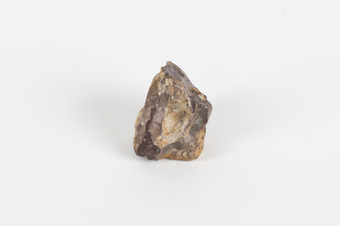
Geological specimen - Common Opal, unknown
Common Opal is a mineraloid that is non crystallising and is classed as an amorphous silicate, the chemical composition for Opal is SiO2 nH2O. Opals can develop in weathered sedimentary rock typical in arid regions where limited water enters small gaps in the rock, and the silicate is hydrated. Common opals, unlike precious opals, do not exhibit ‘play of colour’ in which the colour appears to change depending on the angle of view. While precious opals are highly valuable and cut as gemstones for jewellery, common opals can be cut into inexpensive gemstones and are also mined for various uses including as ingredients in ceramics, insulation, fillers, and abrasives. The source of this common opal specimen is unknown, but common opals are found around the world, notable deposits are found in Queensland, South Australia, New South Wales, Peru, Kenya, Nevada, Oregon, and Mexico. This common opal specimen is of historic and scientific significance due to its donation in 1868 as part of the Geological Survey of Victoria and as a typical example of uncut common opal. This specimen is part of a larger collection of geological and mineral specimens collected from around Australia (and some parts of the world) and donated to the Burke Museum between 1868-1880. A large percentage of these specimens were collected in Victoria as part of the Geological Survey of Victoria that begun in 1852 (in response to the Gold Rush) to study and map the geology of Victoria. Collecting geological specimens was an important part of mapping and understanding the scientific makeup of the earth. Many of these specimens were sent to research and collecting organisations across Australia, including the Burke Museum, to educate and encourage further study.A palm-sized amorphous (non-crystallising) hydrated silicate mineraloid specimen in shades of brown, orange, and white.Existing label: Common Opal / Locality unknowngeological specimen, geology, geology collection, burke museum, beechworth, common opal, opal, mineraloid, amorphous silicates, hydrated silicate -
 The Beechworth Burke Museum
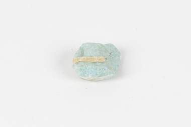
Geological specimen - Amazonite, unknown
Amazonite is classed as a Tectosilicate and is part of the Feldspar group of minerals. Amazonite forms in a triclinic crystal structure and its chemical formula is K(AlSi3O8). In appearance, Amazonite can range from shades of green to green blue to blue, and often with white streaks or veining. The greenish colour is believed to come from the small amount of lead contained in its composition. Amazonite is named after the Amazon River due to its colour and similarities to another rock found along the riverbanks, although Amazonite is not actually found at or near the Amazon. Although less commonly used in jewellery today, Amazonite has been mined and used by humans for thousands of years and Amazonite jewellery from at least 2000BCE have been discovered in North Africa. Amazonite is found in many locations around the world including Brazil, Peru, Ethiopia, Canada, Russia, Mozambique, Myanmar, Pakistan, China, Madagascar, and the United States of America. This specimen most probably comes from the U.S.A., Amazonite is found in several US states particularly in Colorado, Virginia, Pennsylvania. This specimen is of both scientific and historic significance as a striking blue green example of Amazonite mined prior to 1868 in the United States of America, most likely from Colorado, Virginia, or Pennsylvania. These three states are all locations of significant Amazonite deposits. This specimen is part of a larger collection of geological and mineral specimens collected from around Australia (and some parts of the world) and donated to the Burke Museum between 1868-1880. A large percentage of these specimens were collected in Victoria as part of the Geological Survey of Victoria that begun in 1852 (in response to the Gold Rush) to study and map the geology of Victoria. Collecting geological specimens was an important part of mapping and understanding the scientific makeup of the earth. Many of these specimens were sent to research and collecting organisations across Australia, including the Burke Museum, to educate and encourage further study.A palm-sized Feldspar mineral specimen from the Tectosilicate class in shades of blue-green with white veining.Existing label: green/blue Feldspar / "amazonite" / possibly USA geological specimen, geology, geology collection, burke museum, beechworth, tectosilicate, amazonite, feldspar, triclinic crystal structure, amazonite usa, amazonite colorado, amazonite virginia, amazonite pennsylvania -
 The Beechworth Burke Museum
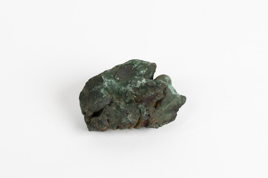
Geological specimen - Malachite, Unknown
This specimen is a copper-carbonate malachite mineral. It is often found as crystalline aggregates or crusts, which have a banded agate-like appearance while also commonly found as botryoidal clusters of radiating crystals. Malachite is often bright green in colour, with dark green and blackish blooms or stripes/bands throughout the mineral. This particular specimen was recovered from the Burra Burra Copper Mine located Burra, South Australia. By the 1860's, South Australia was known as the "Copper Kingdom" due to its large amount of copper mines and huge success in the copper mining industry. Burra Burra was no exception to this phenomena, as this mining company was greatly famous and successful, being nicknamed the "Monster Mine". It was first established in 1848 and was the largest metal mine in Australia up until 1860. This specimen is significant as it highlights the historic use and value of malachite and the rarity of the mineral. Malachite is a rare gemstone which has been used in various ways historically. It has been cut and sculpted into beads for jewellery use as its rich colour and distinct yet unique patterns have made it a well sought after gemstone. Its' continued use over time only heightens the value and significance of this mineral.A hand-sized solid copper-carbonate hydroxide mineral specimen in shades of blue, green and copper tones throughout.MALACHITE / (Copper carbonite) / Locality: Burra, South Aust. | Malachite / Burra Burra / South Australia / (good specimen) / needs a wash / BBburke museum, burke museum collection, beechworth museum, beechworth, geological specimen, geological, mineral, mineraology, copper carbonate, malachite, burra burra mine, copper mining -
 The Beechworth Burke Museum
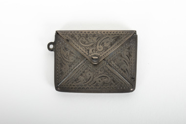
Functional object - Silver Stamp Case, unknown
Stamp cases/holders began being produced in the late 19th century, commonly made of gold, wood, and silver. In this case, the item is made of sterling silver and has patterns and details etched into the metal sheets that make up the case. Sterling silver is the standard alloy used in jewellery and detailed metalworks with its physical properties making it maleable and corrosion resistant, therefore a favourable metal to work with both across many centuriesn the past and present. Stamp cases where popularised by James Allen of Birmingham who created and registered the stamp holders he made. As they gained popularity, it was common for stamp holders to consist of multiple compartments holding various small items such as matches, strikers and of course stamps. Metalwork and silverwork has been a prominent proffession and artform historically and socially for many years. There are many different types of metal work to specialise in and distinct patterns and inscriptions for identifying the provenance of the item. Hallmarking is this proccess of inscribing the item, and consissts of four main components (including assaying) which can indicate the date of creation. Unfortunately this item has no hallmark, therefore it is relatively unknown where, what, when and who created it.This item is of social and historic significance as it highlights the importance of preserving histoical items. This item display's the intricate and highly skilled trades of the past with a glimpse into the social and cultural aspects of the beechworths' history.A small, silver stamp holder with decorative details etched into the metal. It has a small loop on the left side of the case, indicating it could be connected and held by a chain or ring. A01145 (obejct number): A01145 [object number inside stamp case] / STERLING SILVER [inscription inside stamp case]metalwork, silver, silverware, sterling silver, stamp holder, stamp case, burke museum, social history, burke museum collection, beechworth -
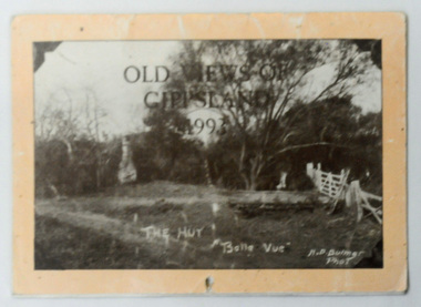 Orbost & District Historical Society
calendar, Old Views of Gippsland 1993, 1992
This item is a useful pictorial reference tool.A 1992 stapled pictorial annual calendar, titled "Old Views of Gippsland".On the front is a black/white photograph of "The Hut Belle Vue" taken by H.D. Bulmer. It contains early photographs of East Gippsland, one for each month. The photographs are sepia. There is a hole for hanging. Some dates have appointments recorded in pen.calendar-old-views-of-gippsland photographs-historic-gippsland -
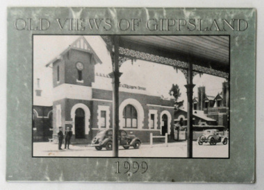 Orbost & District Historical Society
calendar, Old Views of Gippsland 1990, 1998
This is a useful pictorial reference tool.A 1999 stapled calendar, titled "Old Views of Gippsland".On the olive green coloured front is a black/white photograph of 1950's Bairnsdale Post & Telegraph Offiice. It contains early photographs of East Gippsland, one for each month. There is a hole for hanging. calendar-old-views-of-gippsland photographs-historic-gippsland -
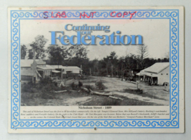 Orbost & District Historical Society
calendar, Snowy River Mail, Continuing Our Federation, 2001
This item was used in the Slab Hut (Orbost Visitor Information Centre).This item is a useful pictorial reference tool on the history of Orbost.A 2002 stapled calendar, titled "Continuing Our Federation".On the front is a black/white photograph of the main street of Orbost. It has blue print and an ornate blue frame. It contains photographs of earl Orbost, one for each month. on front cover -"SLAB HUT COPY" in red felt tip pen.calendar-continuing -our-federation photographs-historic-orbost -
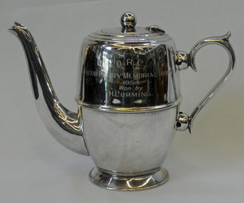 Orbost & District Historical Society
trophy, 1950's
This trophy was won by H. Cumming, member of the Orbost Rifle Club. Harold Cumming was the son of William Cumming a Bete Bolong farmer who was a Shire councillor, a well-known local sportsman and a Rechabite. Jacob Perry was an Orbost farmer. Born 1874. Died 1950. He was a Boer War veteran , 4th Victorian Imperial Bushmen. a shire councillor and worker for school affairs.This trophy, in excellent condition, is aesthetically significant as well as having a well-provenanced historic significance. Harold Cumming was the son of William and Ellen (Mundy) Cumming who farmed land at Bete Bolong from c1880s. A silver plated trophy - a coffee pot - won by H. Cumming. It is an Orbost Rifle Club trophy - the Jacob Perry Memorial Trophy - 1954.O.R.C. JACOB-PERRY MEMORIAL TROPHY 1954 Won by H. Cummingorbost-rifle-club trophy cumming-h -
 Orbost & District Historical Society
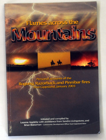
book, Flames Across The Mountains, 2004
This book was initiated and compiled by Leanne Appleby with assistance from Sandra Livingstone and Brian Blakeman. After hearing some of the stories of the events that took place during these fires, Leanne Appleby decided that collating and recording the stories in book form would "perhaps relieve some of the tension and stress". Brian Blakeman as Community Development Officer, East Gippsland Shire, and Sandra Livingstone of Buchan became involved in the project.This is a historic record of events that took place during the 2003 bushfires in the Victoria High Plains.A 206 pp paperback book titled Flames across the Mountains. the front cover is representative of fire and lightning. In the centre is a background of bushfire and the silhouette of two mounted bushmen. The book contains personal accounts of the Bogong, Razorback and Pinnibar fires in East Gippsland, January 2003. It has both b/w and coloured photographs.bushfires reminiscences victorian-high-country -
 Orbost & District Historical Society
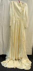
dress, 1945
This dress was worn by Beatrice Coulson on her marriage to Archie Henry Robinson on 17.3.1945 at the Methodist church in Orbost.The wedding gown is provenanced and in good original condition and is of historic significance as an object directly related to the Robinson and Coulson families.A hand-made long magnolia slipper satin wedding frock with a high draped neck and full flared skirt. It has a train at the back. It has long sleeves , covered buttons on the back, shirring on the front and a decoration of white flower shapes on the front.coulson-beatrice robinson-archie wedding-dress costume -
 The Beechworth Burke Museum
Photograph
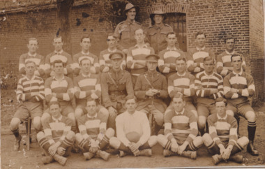
Taken some time between 1914-18, depicted is a large group of unidentified males. Four of them are dressed in Australian military uniforms. The remaining 19 men are dressed in striped uniforms. The male in the centre of the front row is cradling a football, suggesting that the group was part of a football or rugby league team. It is believed that the soldiers in this photograph were part of the Australian Imperial Force. This can be inferred by the chevron rank insignia visible on their uniforms. The placement of this insignia on the sleeve of the right arm suggests that this soldier was either a Warrant Officer or a Non-Commissioned Officer (NCO). Additionally, they are also wearing 'Rising Sun' collar badges on their coats. Australia, unlike most other Commonwealth countries, did not adopt metal regimental badges during the First World War. All units were issued with the Australian Army General Service Badge, better known as the 'Rising Sun’ badge. This insignia is almost always identified with the Australian Imperial Force. Sport has always been entwined with war. Both sport and war demand peak physical fitness, camaraderie, strategy, and allegiance to a team collaboratively working towards a common goal: to win. The connection between sport and war is especially strong in Australia since these two concepts form the basis of our national identity. The Australian War Memorial has a number of World War I recruitment posters linking war and sport in its collection. One of the posters produced in 1915 by the State Parliamentary Recruiting Committee in Victoria attempted to shame young men into enlisting by juxtaposing the image of an Australian soldier standing guard over his deceased mate with a photograph of a Victorian Football League match. Another poster, produced in 1917, features vignettes of different sports including cricket, bowling, boxing, kayaking and golf. Its slogan reads, "Join Together - Train Together - Embark Together - Fight Together: Enlist in the Sportman's 1000".The record is historically significant due to its connection to World War I. This conflict is integral to Australian culture as it was the single greatest loss of life and the greatest repatriation of casualties in the country's history. Australia’s involvement in the First World War began when the Australian government established the Australian Imperial Force (AIF) in August 1914. Immediately, men were recruited to serve the British Empire in the Middle East and on the Western Front. The record has strong research potential. This is due to the ongoing public and scholarly interest in war, history, and especially the ANZAC legend, which is commemorated annually on 25 April, known as ANZAC Day. Additionally, the record presents a unique opportunity to further explore the relationship between the arts, sport and war. This statement of significance has already established that war is integral to Australia's national identity - and sport is of equal importance. Specifically, the record begs to question how the peak physical fitness and camaraderie valued in team sports were creatively translated into military recruitment campaigns during World War I. Evidently, this record and its historic context demonstrates that there is potential here, and if further research is completed on this topic, it may provide insight into Australian military recruitment tactics used in the past and present, and into the future.Sepia rectangular photograph printed on matte photographic paper mounted on card.Reverse: 6529 / hyossest (?) / (?)1/11/1 /military album, army, military, war, wwi, world war i, sport, football, rugby, aif, australian imperial force -
 The Beechworth Burke Museum
Photograph, Unknown
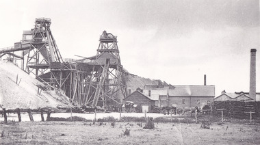
The A1 Gold Mine is located north of Woods Point, near Jamieson, in the Upper Goulburn region of Victoria. Gold was discovered at the A1 site in 1861 and mining operations began in 1864. The A1 Mine Settlement refers to a small township known variously as Castle Reef, Castle Point, and Raspberry Creek, which developed in the 1860s around mining industry centred on a crushing machine that worked the three gold reefs in the area. Historically, the name "A1"referred to the high quality of gold found in the quartz reefs at depths of at least two thousand feet. Along with the Morning Star mine at Woods Point, the A1 gold mine produced almost sixty percent of Victoria's gold output in the 1950s to 1970s and continued operating until 1992 when it went into administration. Operations at the site were revived in 2016 and the A1 Mine is now considered one of Victoria's premier gold mines. The A1 mine is part of the extensive and prospective Lachlan Fold Belt, a north-west trending belt of tightly folded Early Devonian sedimentary rocks extending from New South Wales to Victoria. Mineralisation is hosted within or immediately adjacent to diorite dykes. Contemporary development of the 'Queens Lode' at the A1 mine signals a move from high-grade, narrow vein airleg mining into larger scale, mechanical mining designed to increase ore production volume. This original, undated photograph of the A1 Mine appears to depict an area or phase of disuse or abandonment. The aged and humble appearance of the cottage suggests association with the historical A1 Mine Settlement, therefore the image may have been taken prior to the 1950s-1970s revival period in which the A1 mine is known to have produced high gold yields. The photograph contributes to our understanding of the A1 Gold Mine's impact on the landscape and the social, environmental impacts of mining on communities and may be compared with others in the Burke Museum's extensive collection of mining photographs to deepen our understanding of mining in the Jamieson area.Black and white rectangular photograph printed on photographic paperReverse: 5577 / A1 Mine / Near Jamieson / Vic. /burke museum, beechworth museum, beechworth, gold fields, gold rush, victorian gold rush, mining tunnels, gold ming history, colonial australia, australian gold rushes, mining technology, beechworth historic district, indigo gold trail, indigo shire, upper goulburn shire, jamieson, woods point-walhalla goldfield, a1 gold mine, victorian high country, modern mining methods, orogenic gold province, gold mineralisation, devonian, dykes -
 The Beechworth Burke Museum
Photograph - Photograph - Reproduction, ca. 1900
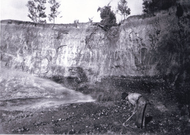
This image shows the approach to Beechworth from the south-west via the Newtown Bridge. Numerous early buildings line the road as it bifurcates to become Ford and High Streets on the ridge above Spring Creek and Newtown Falls. The sloping, rocky terrain and water course along the gorge show evidence of the intense mining activity that occurred at the site. The Ovens Gold Rush at Beechworth started when gold was found at Spring Creek in February 1852, prompting an influx of miners from around the world. The population grew over 20,000 by 1857. While the earliest mining at Beechworth was similar to that in other Victorian goldfields like Ballarat and Bendigo, Beechworth is notable for its use of hydraulic sluicing as a major method of removing wash-dirt. Hydraulic sluicing employs high pressure jets of water to blast away large areas of earth and wash it down to be run through a sluice box. Gold gets caught in the sluice and the remaining slurry is washed away. This method of mining is extremely effective but causes significant environmental impacts and damage to waterways. Large water quantities were required for large-scale sluicing, and the long water races and deep tailraces that were constructed in the Beechworth area in the nineteenth century are nonetheless considered feats of engineering. The site in the photograph is associated with the Rocky Mountain Mining Company who constructed an eight hundred meter tunnel under the township between 1876-1880 to reduce water levels at Spring Creek, which had been subject to diversions since the earliest days of alluvial mining. Over four million ounces of gold (115 tones) were found at Beechworth between 1852 and 1868, and the wealth from the gold rushes built Beechworth and the nationally significant buildings that remain standing today.This image shows the early development of the Beechworth township above Spring Creek, where gold was discovered in 1852. Evidence of hydraulic sluicing, a uniquely predominant method at Beechworth, and water-works engineering are present in the landscape. By the 1870s, alluvial gold deposits were depleted and increasingly complex engineering was required so deeper shafts could reach bedrock. This image is significant for understanding changes to the landscape and the evolution of mining methods and engineering practices related to the extensive construction, manipulation and management of water networks. The shift from smaller scale alluvial mining to larger company dominance in the mining industry has implications for understanding wider social, economic, political and industrial changes in the region of Beechworth and within the context of the Victorian Gold Rush more broadly. A black and white rectangular reproduction photograph printed on photographic paper. burke museum, beechworth museum, beechworth, gold fields, gold rush, victorian gold rush, hydraulic sluicing, rocky mountain mining company, spring creek, netwown falls, mining tunnels, water races, tailraces, colonial australia, australian gold rushes, mining technology, beechworth historic district, indigo gold trail, migration, indigo shire, gold mining, gold mining history -
 The Beechworth Burke Museum
Photograph - Photograph - Reproduction
This photograph depicts the Great Southern Mine located in Rutherglen as it was during the 1900. After the initial Gold Rush of 1853-1854, Gold was discovered deeper under the surface of the earth in the 1860 after the discovery of another deep lead system. Due to the discovery of Gold in Rutherglen, Rutherglen developed into a community in its own right, possessing a population of 6600 by December 1860 and developed into a municipality in 1862. The Great Southern Mine depicted in this photograph required the use of a range of modern technologies, including the hydraulic pumps, in order to reach gold. This photo depicts the mining operations as they were undertaken around the turn of the century.The search for gold is ingrained into the history of Victoria and therefore, images like this one which portray a modern mining operation undertaken in the 1860s, can reveal important information for society and technology for the date when the photograph was taken. This image is of important historical significance for its ability to convey information about the methods used to extract gold in 1900. It is significant as most mining operations around the region, particularly earlier on in the period, used different technologies such as water races. This image is important for current research into the history of Rutherglen more generally, a town which developed singlehandedly due to the discovery of minerals and mining, as depicted here in this photograph, thus indicating an element of social significance as well as historic. The Beechworth Burke Museum has additional images relating to mining and Rutherglen which can be analysed and studied alongside images like this one.A black and white rectangular photograph printed on matte photographic paper.Reverse: $ 3.00 19972503 / a02503 / Great Southern Mine Rutherglen 1900rutherglen mine, rutherglen, great southern mine, beechworth, mine, mining, post goldrush, victoria, gold, 1860s, sluicing, hydrolic sluicing -
 The Beechworth Burke Museum
Photograph - Photograph - Reproduction, Unknown
This image is a reproduction of an 1899 original depicting the 'Williams Good Luck Mine' on the Mopoke Reef (also called 'Morepork Gully') in the Dingle Ranges, approximately three miles from Beechworth. The foreground of the image is littered with piles of smashed rock and detritus, known as ‘mullock’, beside a reinforced mine shaft, a vertical access passageway allowing miners to enter the mine and haul ore out using lifting technology such as a poppet heads, whims or windlasses. A group of miners and a dog appear close to an open-sided miner’s hut. Following the discovery of gold at Beechworth in 1852, rushes quickly followed at surrounding creeks and gullies in the district. In the late nineteenth and early twentieth centuries, small syndicates of miners continued to work old or abandoned quartz reefs, often persisting without the assistance of heavy machinery to remove the large amounts of rock, in order to obtain yields at ever greater depths. The group of miners in this photograph are Mr. Roger Williams and Sons, who revived operations at the ‘Old Good Luck’ mine on the Mopoke Reef in the Dingle Range near Beechworth around 1892, working the site for more than two decades. An emigrant from Cornwall with experience in the tin mining industry, 19 year old Roger Williams senior sailed to New Zealand in 1840, then to Australia where he spent time in the Bendigo Gold Fields before settling in Beechworth in the early 1860s. Mr Williams senior worked on various mining activities in the district, including the Rocky Mountain Tunnel project. Conversant with the character of gold-bearing reefs in the area, the syndicate dug an eight hundred foot tunnel, digging down as far down as two hundred feet with little capital save their labour, to connect and provide better working access to the mass of reefs and veins in the vicinity. Progress was hampered by poor air quality charged with fumes from dynamite and large quantities of rock had to be crushed to obtain payable yields. The Victorian Goldfields are filled with ruins and remnants of the area's rich mining history, ranging from small alluvial diggings to the remains of huge mining companies. Site names often changed several times throughout the nineteenth and twentieth centuries. Some sites were abandoned and forgotten, others were worked continuously over many decades. The names of mines were often repeated at different locations throughout the Victorian Goldfields. For example, there is a Mopoke Gully heritage mine near Fryers Creek, Victoria. 'Mopoke' is a common onomatopoeic name for Morepork and Australian Boobook owls. This image has historical, social and research significance for patterns of emigration during of the Victorian Gold Rush, and the historical, social and environmental impacts of mining at Beechworth at the turn of the nineteenth and twentieth centuries. As gold became scarce and government support and large company investment waned, poor hard-working miners laboured intensively to make a living through periods of high unemployment. This image can be compared and studied alongside other historical mining photographs and objects in the Burke Museum Collection. It has potential to improve our understanding of miners working conditions and the shifting character of mining in the Beechworth district. Black and white rectangular reproduction photograph printed on matte photographic paper.Obverse: Williams Good Luck Mine Beechworth / Roger! / Reverse: 6858 / burke museum, beechworth museum, beechworth, gold fields, gold rush, victorian gold rush, gold ming history, colonial australia, australian gold rushes, mining technology, beechworth historic district, indigo gold trail, migration, indigo shire, good luck gold mine, victorian goldfields, mining syndicates, gold fever, quartz-mining, small-scale mining, old good luck mine, mopoke gully, quartz reefs beechworth -
 The Beechworth Burke Museum
Photograph, 1920-1950
This image taken between 1920-1930 depicts open-cut hydraulic sluicing at the Three Mile Mine, located about five kilometres south of Beechworth. Alluvial, or surface, mining began on this site in the 1850s, but was soon replaced by hydraulic sluicing methods. By the start of 1880 it is estimated that nine hundred miles of water races had been cut though soil and rock in the Beechworth district. Hydraulic sluicing employs high pressure jets of water to blast away large areas of earth and wash it down to be run through a sluice box. Gold gets caught in the sluice and the remaining slurry is washed away. Large water quantities were required for hydraulic sluicing, and the long water races and deep tailraces that were constructed were considered great engineering feats. This method of mining is extremely effective, but causes significant environmental damage and impacts to waterways and agricultural operations. Miners at Beechworth built extensive networks of races and dams to secure reliable supplies of water on a scale far greater than elsewhere in Victoria. By the 1880s Beechworth's water barons continued to hold more than half of all the water right licences on issue and undertook sluicing operations on a massive scale. The manipulation of surface and ground water via race networks was well planned and recorded in detail by local mining surveyors. The maps that were created, combined with modern geo-spatial technologies, provide a vital key in understanding the great lengths to which miners went to capture and control critical water resources. Today, Three Mile mine is called Baarmutha. The Three Mile Mine was unproductive until 1865 when John Pund and three other miners secured a fifteen year license and constructed a water race from Upper Nine Mile Creek to Three Mile Creek. In the early twentieth century Pund & Co. averaged over one thousand ounces of gold per year from the mine. After Pund's death in 1915, GSG Amalgamated Co operated the site, continuing sluicing until 1950. This image of hydraulic sluicing methods shows the extent of water-works engineering in the landscape. This photograph has historic and research potential for understanding changes to the landscape, the evolution of mining methods, and the extensive construction, manipulation and management of water networks in the Beechworth district. Black and white rectangular photograph on matte paperReverse: 7597-1 / Sluice Mining / Copied from original on loan from Webb (Qld) / Donated Nov 2009 / Baarmutha Three Mile Mine c1920-1950 / Managed by the Plain Bros then Parkinsons / Current Location is: Beechworth Animal Shelter / used for Baarmuthaburke museum, beechworth museum, beechworth, gold fields, gold rush, victorian gold rush, hydraulic sluicing, spring creek, netwown falls, mining tunnels, water races, tailraces, gold ming history, colonial australia, australian gold rushes, mining technology, beechworth historic district, indigo gold trail, indigo shire, john pund, water manipulation, water engineering, three mile creek, three mile mine, water race, large-scale mining methods, historical mining construction, alluvial mining, mining environmental impacts, baarmutha, water barons -
 The Beechworth Burke Museum
Photograph, Circa 1920 - 1950
Taken between circa 1920 - 1950 this photograph depicts a man dressed in dark trousers, a white long sleeved shirt and broad-brimmed workers hat digging around in the Three Mile Mine at Barramutha. The mine was an important gold resource and was typically mined using a method known as hydraulic sluicing whereby high powered water jets are used to dislodge rock or move sediment. The remaining water sediment slurry is directed through sluice boxes to remove the gold. The Beechworth mining district was one of six mining districts established by the governor-in-council on 4th of January 1858 under the provisions of An Act for Amending the Laws Relating to the Goldfields (21 Vic no. 32). This photograph shows historic and research value into the historical methods of hydraulic sluicing in the Beechworth mining disctrict. It also shows the evolution of the mining methods and has potential for understanding future engineering endeavors in the context of victorian mine goldfields. Black and white rectangular photograph printed on matte photographic paper.Reverse: 7597.3/ Copied from original on loan from Webb (QLD)/ Donated Nov 2009/ Barnawatha Three Mile Mine 1920-1950/ Owned by Plain Bros then Parkinsons/ Managed by John Weir, Peter Jenson, Jack Cox/ Slicing. three mile creek, three mile goldfields, three mile beechworth, goldfields, #beechworth, hydraulic mining, hydraulic sluice, burke museum -
 The Beechworth Burke Museum
Photograph
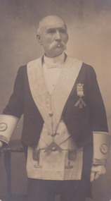
This photograph, taken by Courtney’s Thelma Studios in Wangaratta, depicts Sergeant Arthur Loftus Maule Steele standing in the regalia of the Masonic Lodge. Before his death, Steele was a long term member of the St John’s Lodge of Masons where he was a Past Master and held office of treasurer for over thirty years. He was also a dedicated member of the Church of England and was an Electoral Inspector for Wangaratta. Steele was Sergeant of Police in Wangaratta for much of his life. He was one of 17 children born to Captain Robert Ball Steele and Mary Babington in Tours, France, in 1839. His parents were travelling at the time and soon after settled in Donegal, Ireland. At the age of 12, Steele was sent to the Military Academy of Dublin where he passed his examinations and prepared to enter the British Army. Steele met a bother of Robert O’Hara Burke and was advised to travel to Australia and join as a police cadet. Steele took the advice and travelled to Australia, arriving in Melbourne at the age of 17. He spend some time in a variety of employment including working as a clerk for the White Star Line. He entered the Victorian Police force in 1856. By 1864, Steele married Ruth Ingram Ballinger at Snowy Creek and worked at Omeo until being promoted to the mining centre of Beechworth, taking charge of the Yackandandah Station. Steele and Ballinger had ten children. Steele is well known in Victorian history for a variety of reasons, the most famous being the role he played in capturing Edward “Ned” Kelly at Glenrowan on the 28th June 1880. He also arrested Frank Neville (for the murder of a local resident Mr Nicholls) and Patrick Sheehan (first person to be executed in the Beechworth Gaol 1865 for the murder of James Kennedy at Rowdy Flat Yackandandah). He later worked on the case of Bridget Mepham (charged with the murder of her sister) at Wangaratta and retired from the Police force on the 1st of August 1896. In this retirement, Steele was a keen horticulturalist who enjoyed observing the habits and growth of new varieties cared for in his conservatory. Steele passed away in February 1914. This image has the potential to support current research on Sergeant Steele, the Masonic Lodge and photography during the c.1890s. Sergeant Steele is a well-researched member of the Victorian Police force and is known primarily for his involvement with the Kelly Gang. Therefore, depictions of Steele through photography can help to provide essential information about Steele outside of the Police force. This image has the capacity to inform about Steele’s involvement with the Masonic Lodge in Wangaratta. Therefore, it is important for what it can reveal regarding historic and social aspects. The Burke Museum is home to a large collection of Kelly centred photographs. The study of these photographs in connection to those in other museums have the ability to further current understanding on important figures and events in this historic occasion.Black and White rectangular photograph printed on matte photographic paper and mounted on an oval boardObverse: Courtney's Thelma Studios/ Wangaratta Reverse: 2747portrait, ned kelly, uniform, policeman, wangarratta, sergeant, steele, 1880, photograph, oval, black and white, sergeant steele, arthur loftus maule steele, arthur steele, wangaratta, beechworth -
 The Beechworth Burke Museum
Photograph, J. Collins, c.1940-1950s
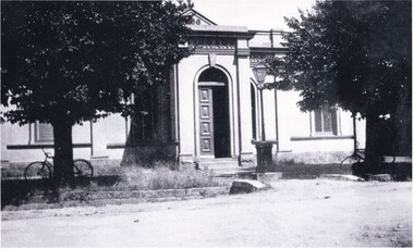
This photograph was captured sometime between an estimated 1940s-1950s. It depicts the Beechworth Benevolent Asylum (later the Ovens and Murray Hospital for the Aged) which was built in 1862. It is located on an elevated site in Beechworth, Victoria because it was believed the height was beneficial to the health of the patients at the Benevolent. Later wings were added to the original building between 1867 and 1890. The building was constructed in an unusual Flemish Gothic Revival style which contrasts with the classical style of the Mayday Hills Hospital in close proximity to the Benevolent. The Hospital was designed in Italianate Revival architecture. The appearance of buildings like the Mayday Hills Hospital and the Ovens Benevolent Asylum are representative of the importance of Beechworth as a town shortly after the goldrush. During the 1850s and 1860s, administration buildings were erected alongside churches, shops and structures of justice. This marks a movement away from the "chaotic" structure of life on the goldfields and towards a more civilised and cultural lifestyle. This social phenomenon is also witnessed in Melbourne with the creation of buildings like the State Library and the University of Melbourne. The Beechworth Benevolent Asylum was renamed the Ovens Benevolent Home in 1935. The Asylum had been set up to provide accommodation and care for permanently injured gold miners, and for women and children who were penniless, homeless, or whose parents were guests of the state. In 1954 it was renamed as The Ovens and Murray Home (as pictured in this photograph). The purpose of this building was to provide a refuge for the poor and destitute, homeless older men, deserted women and children along with providing care for the mentally ill. These buildings were built at the government's expense and are of great historical and architectural significance.This photograph depicts the Ovens and Murray Home (previously the Ovens Benevolent Home) during the 1940s or 1950s. Since this building is of great historic and architectural significance, photographs like this are especially valuable in reconstructing the use history and any changes/additions to the building over a period of time. This building is important for what it can reveal about society in Beechworth and also architectural styles. This building is made in the Flemish Gothic Revival style which is quite unusual for the 1860s. It is important as an early example of a building constructed for a specific purpose, in the case of this particular building: caring for the aged/destitute. This building is important for research into the civic development of Beechworth as an early Gold Rush town located in Victoria's North-East. During this period, Beechworth was developing as the main center of administration in this region which made it a very influential and quickly developed town. Photographs like this one which depict a building during one period in history can reveal important information for the use and alterations of a building and for preferences in architectural style. It can also be studied for what it reveals about society in Beechworth and compared and contrasted to similar institutions across Australia and with additional photographs in the Burke Museum collection.Black and white rectangular photograph printed on gloss photographic paperObverse: OVENS & MURRAY HOME / Reverse: KODAK PAPER / 727 / J. Collins BMM 8689.1 /mayday hills, beechworth benevolent asylum, ovens benevolent home, asylum, refuge, poor and destitute, goldrush, flemish gothic revival, architecture -
 The Beechworth Burke Museum
Photograph, J. Collins
This photograph was captured sometime between an estimated 1940s-1950s. It depicts the Beechworth Benevolent Asylum (later the Ovens and Murray Hospital for the Aged) which was built in 1862. It is located on an elevated site in Beechworth, Victoria because it was believed the height was beneficial to the health of the patients at the Benevolent. Later wings were added to the original building between 1867 and 1890. The building was constructed in an unusual Flemish Gothic Revival style which contrasts with the classical style of the Mayday Hills Hospital in close proximity to the Benevolent. The Hospital was designed in Italianate Revival architecture. The appearance of buildings like the Mayday Hills Hospital and the Ovens Benevolent Asylum are representative of the importance of Beechworth as a town shortly after the goldrush. During the 1850s and 1860s, administration buildings were erected alongside churches, shops and structures of justice. This marks a movement away from the "chaotic" structure of life on the goldfields and towards a more civilised and cultural lifestyle. This social phenomenon is also witnessed in Melbourne with the creation of buildings like the State Library and the University of Melbourne. The Beechworth Benevolent Asylum was renamed the Ovens Benevolent Home in 1935. The Asylum had been set up to provide accommodation and care for permanently injured gold miners, and for women and children who were penniless, homeless, or whose parents were guests of the state. In 1954 it was renamed as The Ovens and Murray Home (as pictured in this photograph). The purpose of this building was to provide a refuge for the poor and destitute, homeless older men, deserted women and children along with providing care for the mentally ill. These buildings were built at the government's expense and are of great historical and architectural significance.This photograph depicts the Ovens and Murray Home (previously the Ovens Benevolent Home) during the 1940s or 1950s. Since this building is of great historic and architectural significance, photographs like this are especially valuable in reconstructing the use history and any changes/additions to the building over a period of time. This building is important for what it can reveal about society in Beechworth and also architectural styles. This building is made in the Flemish Gothic Revival style which is quite unusual for the 1860s. It is important as an early example of a building constructed for a specific purpose, in the case of this particular building: caring for the aged/destitute. This building is important for research into the civic development of Beechworth as an early Gold Rush town located in Victoria's North-East. During this period, Beechworth was developing as the main center of administration in this region which made it a very influential and quickly developed town. Photographs like this one which depict a building during one period in history can reveal important information for the use and alterations of a building and for preferences in architectural style. It can also be studied for what it reveals about society in Beechworth and compared and contrasted to similar institutions across Australia and with additional photographs in the Burke Museum collection.Black and white rectangular photograph printed on gloss photographic paperBack of photograph. Handwriting: "For John Beckingsale"mayday hills, beechworth benevolent asylum, ovens benevolent home, destitute, gold town, beechworth, victoria, north-east vic -
 The Beechworth Burke Museum
Photograph, George Peach, c. 1930
Black and White photograph taken of the Robert O'Hara Burke Memorial Museum. The museum is named in honor of explorer and former Beechworth Superintendent Robert O'Hara Burke following his death in 1861.This item is significant because it shows the historic Burke Museum in a historic context, which can be used to document the changes in the building and the surroundings which have occurred over time.Copy of a black and white landscape photograph on photographic paper.burke museum, robert o'hara burke, robert o'hara burke museum -
 The Beechworth Burke Museum
Photograph, Beechworth Candid Photos, Unknown c1869-1940
The Powder Magazine was built in 1859 by T Dawson and Company for fifteen hundred pounds and was restored in 1966 by the National Trust. The building was constructed to store black-powder used by miners on the goldfields for blasting for mining and quarrying as legally, miners had to leave bulk gunpowder the Powder Magazine overnight. Due to the passing of an 1857 act regulating the importation, transportation and importation of black powder, several Powder Magazines like the Beechworth Powder Magazine were constructed. The Magazine Powder is uniquely designed to ensure that in the chance of an explosion, the explosion is minimalized by travelling vertically rather than horizontally. The Powder Magazine was constructed using granite, slate roofing and a high stone wall and includes several safety features including wooden nails, lightning rod and a solid outer wall. This photograph is historically significant as it documents the development of laws related to mining, the actions taken to ensure the safety of those nearby potentially dangerous equipment and the architectural skills to design a storage facility to minimize damage caused by a potential explosion. A sepia toned rectangular photograph printed on matte paper.Reverse: Beechworth Candid Photos/ Phone 281570/ 5 Finch Street 3747/historic building, beechworth historic building, powder magazine, beechworth -
 The Beechworth Burke Museum
Photograph - Postcard
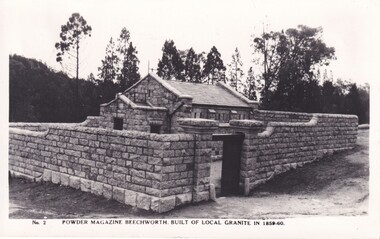
The photograph is of the Powder Magazine and gorge in Beechworth. The Magazine was built for six hundred and ninety-seven pounds in 1859 by "T Dawson and company." However, the walls were constructed later in 1860 by "Atchison and Lumsden," a different building firm. The Beechworth Magazine was one of many made by the government for the storage of gunpowder. However, the building eventually stopped being used as the mining decreased in the area, finally becoming unsused with the invention of nitro-glycerine compounds. The magazine was created to hold large quantities of gunpowder and much of its design was to hinder the prospective of damage. These safety features included double arched foundations and an arched inner roof, which would move a possible explosion upwards. Also, a process of lighting conductors, ventilation and heavy granite walls were incorporated in the designThe photograph shows historic significance due to its association with the mining era in Beechworth in the late 1800s. The photo shows the Powder Magazine after construction in 1960, most likely when it was storing gunpowder during a signifiant time period for the region.Black and white rectangular postcard printed on cardObverse: No 2 POWDER MAGAZINE BEECHWORTH. BUILT OF LOCAL GRANITE IN 1859-60. Reverse: KODAK / POST CARD / CORRESPONDANCE. ADDRESS ONLYbeechworth, powder magazine, gunpowder, mining, beechworth powder magazine, explosives, atchison and lumsden, t dawson and company, gorge, granite, granite building, 1860 -
 The Beechworth Burke Museum
Photograph, 1930
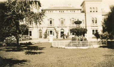
Mayday Hills Mental Hospital was originally constructed in 1864 under the name of the Beechworth Lunatic Asylum. It was built for locals in need of help who were kept in the local gaol. In its first decade, the residents of the hospital were used as menial labourers but over time, as mental healthcare progressed, were cared for in more nuanced ways. This site became a training hospital for nurses in the 1960's. Eventually, mental health patients were moved to other care facilities and Mayday Hills was operating as a geriatric care facility. It was closed in 1995, after which the buildings and their grounds were purchased to La Trobe University to be used as a campus. The university sold the site in 2011 to private ownership. This image depicts the front facade of the building and a portion of the gardens, including a fountain. Mayday Hills Mental Hospital is a historically significant site for many factors. It is representative of healthcare practice in nineteenth century Victoria. It contains rare examples of construction and architecture. It is also significant for aesthetic and technical reasons.Black and white photograph printed on matte photographic paperReverse: Mental Hospital/ Beechworth Lunatic Asylum/ Xmas 1930/ 8190 VELOX (Watermark)mayday, mayday hills hospital, mayday hills, mayday hills mental asylum, beechworth, beechworth asylum, beechworth lunatic asylum, beechworth hospital for the insane, garden, gardens & parks, architecture, historic victorian architecture, healthcare, health, fountain, la trobe university -
 The Beechworth Burke Museum
Postcard, c1910
Mayday Hills Mental Hospital was originally constructed in 1864 under the name of the Beechworth Lunatic Asylum. It was built for locals in need of help who were kept in the local gaol. In its first decade, the residents of the hospital were used as menial labourers but over time, as mental healthcare progressed, were cared for in more nuanced ways. This site became a training hospital for nurses in the 1960's. Eventually, mental health patients were moved to other care facilities and Mayday Hills was operating as a geriatric care facility. It was closed in 1995, after which the buildings and their grounds were purchased to La Trobe University to be used as a campus. The university sold the site in 2011 to private ownership. This postcard depicts the Mayday Hills Mental Hospital (Titled as 'Asylum for insane') from a distance and includes the surrounding grounds and farmlands.Mayday Hills Mental Hospital is a historically significant site for many factors. It is representative of healthcare practice in nineteenth century Victoria. It contains rare examples of construction and architecture. It is also significant for aesthetic and technical reasons.Sepia tone postcard printed on matte cardObverse: Beautiful Beechworth (Vic.) 1880 ft. above Sea Level - General View of Asylum for Insane/ Copyright F. Foxcroft Reverse: 1997.2459/ Post Card/ THIS SPACE MAY BE USED FOR CORRESPONDENCE/ THIS SPACE FOR NAME AND ADDRESSmayday, mayday hills hospital, mayday hills, mayday hills mental asylum, mayday hills mental hospital, beechworth, beechworth asylum, beechworth hospital for the insane, beechworth lunatic asylum, beechworth mental hospital, healthcare, health, rural australia, farm, architecture, historic victorian architecture, classical architecture