Showing 24370 items
matching matthew-creek
-
 Eltham District Historical Society Inc
Photograph, Peter Pidgeon, Manna Gum, Main Road Bridge, Eltham South, 8 Sep. 2021
This significant tree located near the Main Road Bridge and Diamond Creek Trail footbridge over the Diamond Creek at Eltham dates back to the early 1900s. The original timber bridge over the Diamond Creek was built around 1840. It was destroyed by floodwaters in October 1923. A temporary bridge was rigged up but further damaged in April 1924. A new concrete bridge was built and opened in October 1926. The bridge decking was widened along with Main Road to Dalton Street by the Road Construction Authority in 1984., The uygraded bridge was opened in October 1984, 78 years after its original opening.These trees are not only significant for the natural environment but also present a navigational beacon back in time as the environmental landscape is developed around them.Born Digitaleltham south, main road bridge, manna gum, significant tree, diamond creek trail -
 Eltham District Historical Society Inc
Photograph, Peter Pidgeon, Manna Gum, Main Road Bridge, Eltham South, 8 Sep. 2021
This significant tree located near the Main Road Bridge and Diamond Creek Trail footbridge over the Diamond Creek at Eltham dates back to around 1870-1880. The original timber bridge over the Diamond Creek was built around 1840. It was destroyed by floodwaters in October 1923. A temporary bridge was rigged up but further damaged in April 1924. A new concrete bridge was built and opened in October 1926. The bridge decking was widened along with Main Road to Dalton Street by the Road Construction Authority in 1984., The uygraded bridge was opened in October 1984, 78 years after its original opening.These trees are not only significant for the natural environment but also present a navigational beacon back in time as the environmental landscape is developed around them.Born Digitaleltham south, main road bridge, manna gum, significant tree, diamond creek trail -
 Eltham District Historical Society Inc
Photograph, Peter Pidgeon, Manna Gum, Main Road Bridge, Eltham South, 8 Sep. 2021
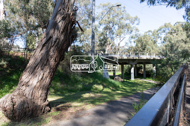
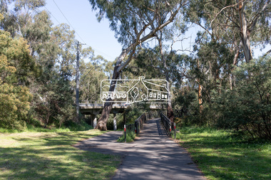
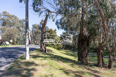
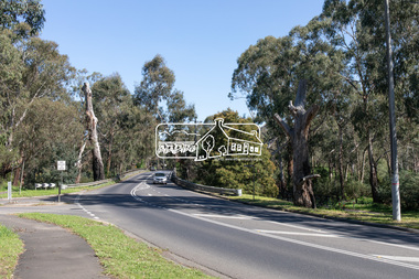
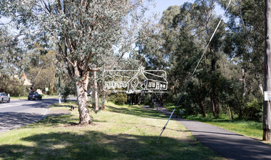
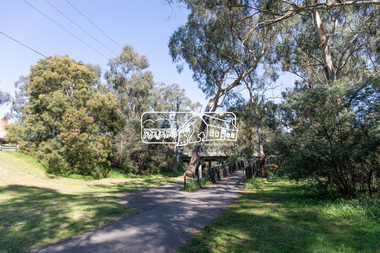
This significant tree located near the Main Road Bridge and Diamond Creek Trail footbridge over the Diamond Creek at Eltham dates back to around 1870-1880. The original timber bridge over the Diamond Creek was built around 1840. It was destroyed by floodwaters in October 1923. A temporary bridge was rigged up but further damaged in April 1924. A new concrete bridge was built and opened in October 1926. The bridge decking was widened along with Main Road to Dalton Street by the Road Construction Authority in 1984., The upgraded bridge was opened in October 1984, 78 years after its original opening.These trees are not only significant for the natural environment but also present a navigational beacon back in time as the environmental landscape is developed around them.Born Digitaleltham south, main road bridge, manna gum, significant tree, diamond creek trail -
 Eltham District Historical Society Inc
Photograph, Peter Pidgeon, Manna Gum, Main Road Bridge, Eltham South, 8 Sep. 2021
This significant tree located near the Main Road Bridge and Diamond Creek Trail footbridge over the Diamond Creek at Eltham dates back to the early 1900s. The original timber bridge over the Diamond Creek was built around 1840. It was destroyed by floodwaters in October 1923. A temporary bridge was rigged up but further damaged in April 1924. A new concrete bridge was built and opened in October 1926. The bridge decking was widened along with Main Road to Dalton Street by the Road Construction Authority in 1984., The uygraded bridge was opened in October 1984, 78 years after its original opening.These trees are not only significant for the natural environment but also present a navigational beacon back in time as the environmental landscape is developed around them.Born Digitaleltham south, main road bridge, manna gum, significant tree, diamond creek trail -
 Eltham District Historical Society Inc
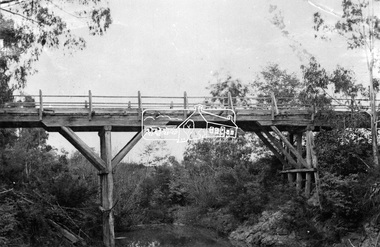
Photograph, Hurst's Bridge, c.1912
The area of Hurstbridge was originally known as Hurst’s-bridge after the timber bridge built over the Diamond Creek near Hurst’s station in late 1881/early 1882 on Hurstbridge-Arthurs Creek Road, Hurstbridge. It was built by John McDonald, of Arthur's Creek and was demolished and replaced in 1917 by a reinforced concrete arch bridge designed by John Monash. Part of a slide show presentation "Bridges & Waterways of the Shire" by Russell Yeoman to the 13 September 1989 Society meeting. The presentation included slides of historic photos from the Shire of Eltham Pioneers collections as well as several recent views. This photo forms part of a collection of photographs gathered by the Shire of Eltham for their centenary project book, Pioneers and Painters: 100 years of the Shire of Eltham" by Alan Marshall (1971). The collection of over 500 images is held in partnership between Eltham District Historical Society and Yarra Plenty Regional Library (Eltham Library) and is now formally known as 'The Shire of Eltham Pioneers Photograph Collection.' It is significant in being the first community sourced collection representing the places and people of the Shire's first one hundred years.Digital imageshire of eltham pioneers photograph collection, 1912, bridge, diamond creek (creek), hurstbridge, hurst's bridge -
 Supreme Court of Victoria Library
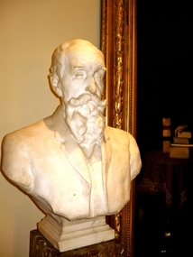
Marble Portrait Bust, Justice Edward Holroyd
This bust was commissioned and made in the years before Holroyd's retirement from the bench. It is not known precisely when the bust entered the Library collection or the circumstances of its execution and commission. Justice Holroyd (1828-1916) was a judge of the Supreme Court for 25 years, after a successful career at the bar. Charles Web Gilbert (1867-1925) was a largely self taught sculptor, only tackling the medium of marble in the years before World War One. After the war he made a number of War Memorials, but his best known work is his statue of Matthew Flinders, the explorer, in Swanston Street.The portrait of Justice Holroyd is of interest as an unusual depiction and commemoration of a Judge. It is notable as a work by the distinguished Australian sculptor Charles Web Gilbert.Marble portrait bust of Justice Edward Holroyd. The bust is made of white carrara marble. The pedestal is made of rouge marble. The bust is slightly larger than life size. The head is finely detailed, Holroyd is shown wearing contemporary clothing, but the detail is less fine, than for the head and beard.The bust is signed and dated 1901 -
 Stawell Historical Society Inc
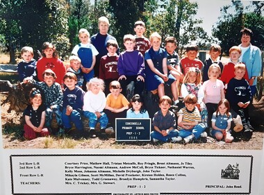
Photograph, Concongella Primary School Students 1995, 1995
3rd Row L to R: Courtney Price, Matthew Hall, Tristan Metcalfe, Roy Pringle, Brent Almann, Jo Tilly 2nd Row L to R: Bryce Harrington, Naomi Altmann, Andrew McColl, Bryce Tickner, Nathaniel Warren, Kelly Moos, Johanna Altmann, Michell Druburgh, John Taylor. Front Row L to R: Mikayla Gibson, Scott McMillan, David Procter, Kristen Holden, Reece Collins, Kate Mulvenney, Todd Greenaway, Broedyn Humphris, Samantha Taylor. TEACHERS: Mrs C Trickey, Mrs G Stewart. Prep 1-2Colour Photograph of Students & TeacherConcongella Primary School Prep 1-2 1995students, education -
 Stawell Historical Society Inc
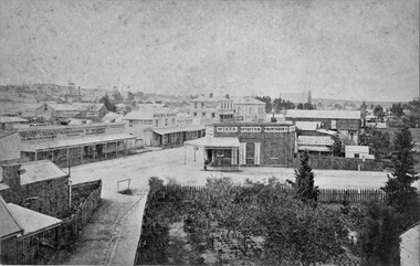
Photograph, Patrick Street and the Corner of Sloane Street with Stawell Court House in the background & St Patricks Church on the Horizon 1878
Patrick Street Sloane Street intersection in the 1880’s (Herbert Photo) On Big Hill side of Patrick Street is Matthew Cairns Plumber & Gasfitter, R. Greenwood Tailor, Mrs. Goodwin Cafe & Restaurant, Mack's Hotel, Grocer, Boot and Shoemaker, J. Farleys Auction Room, J.B. Wallis Royal Exchange Hotel, Stawell Court House and St Patricks Church in Distance On corner of Patrick and Sloane Streets, Melbourne Cash Store Wine Spirits & Provisions. In background mining poppet head behind livery stable. St Patrick Church in distance on right. 1878Patrick St, Sloane St intersection looking south . The Stawell Library now occupies this corner.Victorian Views. C. Herbert, Photo. Stawell 1878stawell business streetscape -
 Ballarat Heritage Services
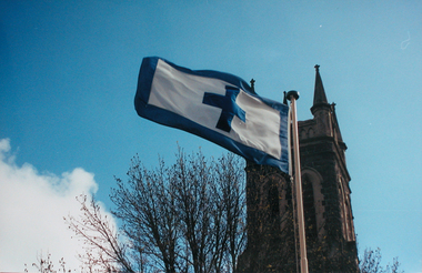
Photograph - Colour, Flag of St Alipius', Ballarat East, 2004, 23/09/2004
"Centenary of Fnrst Mass at Ballarat Friday last marked the centenary of the arrival of the first priest and the celebration of the first Mass in Ballarat. The Rev. Patrick Dunne reached the diggings on October 17, and on Sunday, October 19, 1851, in a bark hut near Brown Hill, he celebrated Mass. Worshippers had to kneel on quartz gravel. The weather had been the worst experienced in Victoria for a number of years, and most of the creeks between Melbourne and Ballarat were flowing torrents, but Father Dunne (who came from the Coburg mission), carrying the barest necessities and the sacred vestments, set out for Ballarat on horseback. He had to ford and swim his horse across the creeks. When most of his congregation left for the Castlemaine diggings Father Dunne returned to Melbourne. In August, 1852, Rev. Matthew Downing became Ballarat's first resident priest. He built a large wooden structure with a canvas roof which served as a church, but later erected at the Gravel Pits the first permanent church. This church was the largest of any house of worship on any goldfield in the colony. It cost £ 100, contributed solely by Father Downing and his flock. Soon after he got the authorities to survey a large piece of land at the back of the township as a burial ground and procured a grant of £500 for fencing it. A grant of £250 was also obtained for the improvement of the chapel and fittings of a school, where Michael Campion Carey opened the first school. Rev. Patrick Smyth succeeded Father Downing, who was followed by Rev. P. Madden, who in 1857 began to plan the erection of St. Patrick's Church. The foundation stone of this was laid by Bishop Goold on February 12, 1858, and the church was opened for the first time on November 8, 1863." (Melbourne Advocate 25 October 1951)Two colour photographs showing the St Alipius' Catholic Church flag - a blue cross and border on white. st alipius, church, ballarat east, flag -
 Phillip Island and District Historical Society Inc.
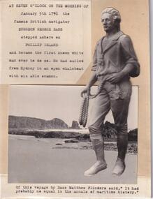
Photograph - Black and White Photograph, Surgeon George Bass
One of a collection of photographs donated by Mr J. W. Gliddon and used in his book "Phillip Island in Picture and Story"Photograph of Surgeon George Bass who came ashore on Phillip Island on the morning of January 5th 1798At seven o'clock on the morning of January 5th 1798 the famous British navigator Surgeon George Bass stepped ashore on Phillip Island and became the first known white man ever to do so. He had sailed from Sydney in an open whaleboat with six able seamen. Of this voyage by Bass, Matthew Flinders said, "It had probably no equal in the annals of maritime history." -
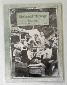 Orbost & District Historical Society
book, E-Gee Printers Pty Ltd, Gippsland Heritage Journal, December 1991
Gippsland Heritage Journal is a journal, produced about every nine - twelve months, for those interested in regional, local and family history in Gippsland, Victoria, Australia. It is compiled by Meredith Fletcher, Debbie Squires and Linda Barraclough and includes a diverse range of articles, both academic and non-academic. Since No.24 it has been a partially refereed journal. This copy was used in the library of Orbost Secondary College. This item is a useful reference tool on the history of Gippsland.A 64 pp magazine, titled Gippsland Heritage Journal No 11 (December 1991). It cost $7.00. The front cover is light green with a b/w photograph of a birthday party for one of the children at Black Snake Creek about 1937. The magazine contains photographs, articles on the history of Gippsland, -
 Bendigo Historical Society Inc.
Document - NOTES ABOUT THE LIFE OF REV MICHAEL CLARKE, 29/3/2007
Document, Rev.Michael Clarke was a Primitive Methodist Minister who was stationed at Castlemaine, Campbell's Creek, and Eaglehawk during the 1850's and 1860's, and one of his sons married into the Avery family of Bendigo. Letter offering Tin Trunk to BHS. Tin Trunk in shipping container 20.1.2022Ian Clarkereligions, christian, primitive methodist -
 Bendigo Historical Society Inc.
Map - EGERTON : COUNTY OF BENDIGO, 1-3-30
Map. Egerton, County of Bendigo, Minto, Diggorra, Elmore, Nolan, Goornong, Bagshot, Whirrakee. Bendigo Creek. By authority J.J. Green, Govt. Printer. Photo-Lithographed at the Department of Lands and Survey, Melbourne. Price 2/-. 1-3-30. (number 47 in map cupboard 1)J.J. Green, Govt. Printer.map, bendigo, egerton -
 Bendigo Historical Society Inc.
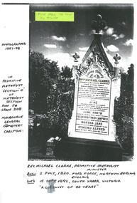
Document - PHOTOGRAPH OF HEADSTONE OF REV MICHAEL CLARKE, 1997
Copy of a photograph of the headstone of Rev.Michael Clarke who was a Primitive Methodist Minister who was stationed at Castlemaine, Campbell's Creek, and Eaglehawk during the 1850s and 1860s, and one of his sons married into the Avery family of Bendigo. Buried at Melbourne General Cemetery. Tin Trunk in shipping container 20.1.2022Ian Clarkereligions, christian, primitive methodist -
 Bendigo Historical Society Inc.
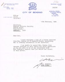
Document - BOWLEN (BOWLAN?) FAMILY: CORRESPONDENCE RE FAMILY HISTORY, 1980
Bowlen (Bowlan?) family - correspondence on enquiry from Mrs Philomena Bowlen, Heidelberg, 1980. re Family History. Seeking information - mention of Edward Timothy Bowlen (born ca. 1856 at Sandhurst or Eaglehawk). Son was John Bowlen (first white baby born at Back Creek?).person, family, bowlen family, edward timothy bowlen (bowlan), silver mines hotel. -
Whitehorse Historical Society Inc.
Legal record - Correspondence, Goldfields and mineral districts of Victoria, 1985
Letter from the State Library of Victoria about location of a gold mime near Koonung Creek in Box Hill North with a reef 2 feet in thickness which yielded 1oz per ton.Letter from the State Library of Victoria about location of a gold mime near Koonung Creek in Box Hill North with a reef 2 feet in thickness which yielded 1oz per ton. Information from R. Brough Smyth 'Goldfields and mineral districts of Victoria'. - 1869Letter from the State Library of Victoria about location of a gold mime near Koonung Creek in Box Hill North with a reef 2 feet in thickness which yielded 1oz per ton. mines and mining, state library of victoria, jackson avenue, box hill north, goldmining -
 Whitehorse Historical Society Inc.
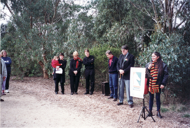
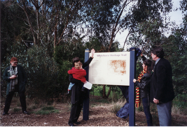
Photograph, Opening of Whitehorse Heritage Trail, 2/07/2001 12:00:00 AM
Heritage Trail funded by grant to the City of Whitehorse from Commonwealth of Australia to celebrate 100 years of Federation.Coloured photograph of Koori Representative speaking at opening of Whitehorse Heritage Trail at Gardiners Creek Reserve, Burwood. From left, Cr. Bill Bowie, Mayor of Whitehorse, Cr. Bernie Millane, Geoff Pascoe, City of Whitehorse, Cr. Kaele Way, and Anna Burke, MHR for Chisholm.whitehorse heritage trail, city of whitehorse, bowie, bill, millane, bernie, pascoe, geoff, way, kaele, burke, anna -
 Whitehorse Historical Society Inc.
Photograph, Opening of Whitehorse Heritage Trail, 2/07/2001 12:00:00 AM
Heritage Trail funded by grant to the City of Whitehorse from Commonwealth of Australia to celebrate 100 years of Federation.Coloured photograph of Anna Burke, MHR, for Chisholm, and the Koori representative unveiling the Display Panel at opening of Whitehorse Heritage Trail at Gardiners Creek Reserve, Burwood. On Right: Cr. Bill Bowie, Mayor City of Whitehorse|On left: Lois Binnie, Heritage & Leisure Manager, City of Whitehorsewhitehorse heritage trail, city of whitehorse, burke, anna, bowie, bill, binnie, lois -
 Whitehorse Historical Society Inc.
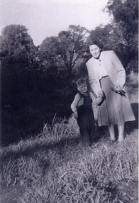
Photograph, Antonio Park - Doris Harris, C1960
The photo is part of a set provided by Robin Harris of his early life (1953-1962) in 'The Shack' at Antonio Park. See ND5241 for his story 'When Antonio Park was home'.)Black & white photograph of Doris Harris (1900-1975) with her grandson, and Robin Harris's nephew, Mark Coleclough. Photo was taken from the eastern side of the shack looking toward Deep Creek Road and showing part of the overgrown fruit orchard in the background. See ND5241 for history.antonio park mitcham, harris. dorothy, coleclough. mark, the shack, whitehorse road, mitcham, no.627, harris. robin, bushfire - 1962 -
 Bendigo Historical Society Inc.
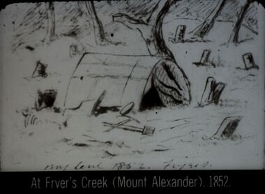
Slide - DIGGERS & MINING. DIGGERS AND MINERS, c1852
Diggers & Mining. Diggers and miners. At Fryer's Creek (Mount Alexander) 1852. Slide; My tent 1852 Fryers St. Shows miners' tent amongst trees some of which have been cut down. Markings: 43 994:LIF I. Used as a teaching aid.hanimounteducation, tertiary, goldfields -
 Bendigo Historical Society Inc.
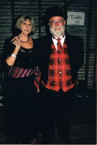
Photograph - PETER ELLIS COLLECTION: PETER ELLIS AND MARG HOGAN
Colour photograph. Man in tartan waistcoat and tie. Woman in long black dress, coloured sash. Corrugated iron wall behind them with toilets boys sign on wall. Back of photo reads: Wedderburn Old Timers Marg Hogan Peter Ellis also Emu Creek.entertainment, dance, bush dance -
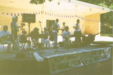 Bendigo Historical Society Inc.
Photograph - PETER ELLIS COLLECTION: EMU CREEK BUSH BAND
Colour photograph. Quite hard to see, photo too dark. Band on stage outside. Banner reading 'The Bush Dance & Music Club of Bendigo with the Emu Creek Bush Band'. Australia flag bunting. Back of photo reads: 5A Sound Shell Rosalind Park Bendigo.entertainment, music, emu creek bush band -
 Bendigo Historical Society Inc.
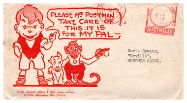
Ephemera - The Sun Newspaper Sunbeams Club Envelopes and Awards, 1943
Parry Collection ‘Sunbeams’ and ‘Corinella’ were two of the few ways an Australian kid could get some acknowledgement and a pat on the back from the big wide world from the 1930s through to the 1950s. The Corinella columns ran in the Sun Newspaper with puzzles, jokes and colouring competitions. Kath Farmer played the role of ‘Corinella’ for yonks and hosted annual ‘Corinella’ Parties for boys and girls aged 5 to 13 years for decades. Sunbeam Certificates were awarded to young readers for good puzzles, riddles, drawings or original stories or verses. The Sun Newspaper Sunbeams Club Envelopes and Awards, envelopes with Ginger Meggs effigy and warning for the postman to take care with the delivery; various certificates received in return for colouring competitions and puzzles submitted back to the Sun Newspaper. Letters were sent to Merle Symons, Orville, Murphys Creek.history, bendigo, sunbeam club sun newspaper, merle lummis collection -
 Kew Historical Society Inc
Photograph - Flooding of the Yarra Valley at Kew East, 1974
Flooding of the Yarra Valley, including that section of the Yarra bordering Kew and Kew East in the north and west of the municipality, was a regular occurrence. Extreme flood events of the Yarra River are recorded to have occurred in 1891, 1901, 1916, 1923 and 1934. The Municipality of Kew's response to these floods was to enact planning decisions restricting residential development in flood prone areas following the floods of 1916, 1921 and 1934. While floods continued after the development of the Upper Yarra Reservoir (construction 1948-57), the regularity and extent of these inundations diminished. During the nineteenth century, the land abutting the south side of the Yarra in Kew was devoted to dairy farming. In the twentieth century, before and after the construction of the Eastern Freeway, much of this low-lying area was used as golf courses and public parks.Late example of the capacity of the Yarra Valley at Kew to flood, even though drainage works and the Upper Yarra Reservoir had reduced their regularity.Original black and white print photograph of the low-lying land at East Kew under floodwater on 16 May 1974. The vantage point of the photographer is Lister Street. In the photo, the fences of the Kilby Farm can be seen. Flooding was caused by overflowing water in Glass' Creek and the River Yarra. Annotation verso: "Hay's Paddock op No.30 Lister Street / 16 May 1974 11.50am / R.L. 46.04"hays paddock, floods, yarra river, glass' creek, lister street -
University of Melbourne, Burnley Campus Archives
Album - Colour prints, Sandra Pullman, Diploma and Degree Excursions, 1996-2001
Photograph Album containing 42 colour photographs. Parks and gardens Tour October 1996 for Diploma of Horticulture to Turkeith, Glenormiston, Boorthoi and Mooramong. Landscape Study Trip August 2001 for Horticulture Degree to Arrandoorong. Landscape Study Trip November 2001 to Brimank - Taylor's Creek shrubland.parks, gardens, 1996, diploma of horticulture, turkeith, glenormiston, boorthoi, mooramong, landscape study trip, arrandoorong, brimank, taylor's creek, shrubland -
 Melbourne Tram Museum
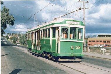
Photograph - Set of two Colour Prints, Jeff Bounds, 27/07/1991 12:00:00 AM
Colour print of Bendigo Tram 24 dressed as its Melbourne number 138 (P class) operating a tour 27/7/1991 operated by Jeff Bounds, in Nolan St. Bendigo. .1 - In Nolan St at the creek bride. .2 - In Bridge St at Nolan St Corner.In ink on the back of each print: "Bendigo, Tram tour run by Jeff Bounds on Sat 27/7/91 before 138 (ex Bendigo 24) was exchanged to Melbourne for SW5 808."trams, tramways, bendigo, nolan st, tours, p class, tram 138, tram 24 -
 Eltham District Historical Society Inc
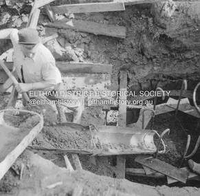
Album - Photograph, J.A. McDonald, Eltham-Greensborough Road, 25 July 1956
Diamond Creek Bridge (Bridge Street Bridge) Chuting concrete for pier No. 1 25th July 1956Record of various Shire of Eltham infrastructure works undertaken during the period of 1952-1962 involving bridge and road reconstruction projects, sometimes with Eltham Shire Council Project Reference numbers quoted. It was during this period that a number of significant improvements were made to roads and new bridges constructed within the shire that remain in place as of present day (2022). In many situations, the photos provide a tangible visible record of infrastructure that existed throughout the early days of the Shire. The album was put together by or under the direction of the Shire Engineer, J.A. McDonald.infrastructure, road construction, shire of eltham, bridge construction, bridge street bridge, eltham, eltham-greensborough road, 1956-07-25 -
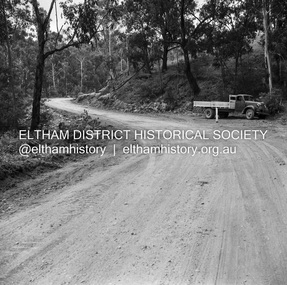 Eltham District Historical Society Inc
Negative - Photograph, J.A. McDonald, Heidelberg-Kinglake Road, Mar. 1960
Job 56M431 Curve improvement north of Yow Yow Creek March 1960 Contractor F.C. WoodRecord of various Shire of Eltham infrastructure works undertaken during the period of 1952-1962 involving bridge and road reconstruction projects, sometimes with Eltham Shire Council Project Reference numbers quoted. It was during this period that a number of significant improvements were made to roads and new bridges constructed within the shire that remain in place as of present day (2022). In many situations, the photos provide a tangible visible record of infrastructure that existed throughout the early days of the Shire. The album was put together by or under the direction of the Shire Engineer, J.A. McDonald.infrastructure, 1960-03, bridge construction, cherry tree road, heidelberg-kinglake road, road construction, shire of eltham