Showing 175192 items
matching nellie-street
-
 Stawell Historical Society Inc
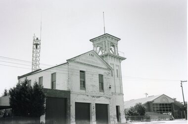
Photograph, Stawell Fire Station in Byrne Street c1887-1890 -- 2 Photos
Stawell Volunteer Fire Brigade. Fire Station with hose reels in front c1887 - 1890s. Byrne Streets Stawell Fire Station Byrne Street built in Sept 1883. Tower built previously. Bell Lady of Stawell was cast in England early 1880.stawell -
 Linton and District Historical Society Inc
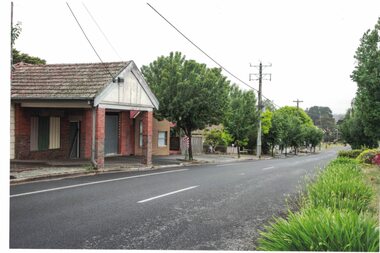
Photograph, Former Bennett Bros Garage Building, Sussex Street, Linton, 2014
The Bennett Bros Garage operated in Linton from the 1930s-1950s. The building is at 79A Sussex Street. Next to the garage building can be seen the building at 81 Sussex Street. In the first half of the twentieth century, it was a shop and residence and operated as a greengrocery and confectionery store.Colour photo which shows a brick building in a somewhat dilapidated condition, with windows and doors boarded up. The building has a tiled roof.bennett bros garage, shepherd's greengrocery and confectionery store, jane craine's confectionery shop, 79a sussex street linton, 81 sussex street linton -
 Melbourne Tram Museum
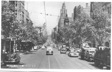
Postcard, Valentine's, "Collins Street Melbourne", late 1930s
Valentine's postcard titled "Collins Street Melbourne", Number V39, looking west from Russell Street with some trams in the far distance. On the right hand side are two trucks carrying large barrels. In the view is the Town Hall and the Manchester Unity building.Yields information about Collins Street during the late 1930s.Postcard - printed, unused, Valentine Seriestrams, tramways, collins st -
 Orbost & District Historical Society
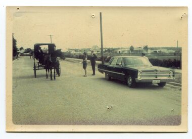
Photograph - Opening of Orbost Museum
This is a photograph of Mr & Mrs Peter Nixon about to board Kaye Lynn's covered jinker which is pulled by a horse to travel to open the Orbost Historical Society's Museum in Nicholson Street, Orbost. The original location of the Museum 1967 was in the building which is now (2022) used by the Cricket Club & Senior Citizens. The Library was also located there. Since 1994 and following the Orbost Shire's amalgamation into East Gippsland, the Library and Museum were located into the Shire's Business Centre in Ruskin Street, Orbost.photograph of an event in Orbost A b/w photograph of large car on the right hand side, two people in the centre, and a horse and sulky on the left. They are in a street.On back: Mr and Mrs Nixon are about to board Kaye Lynn's covered jinker to travel to open Orbost Historical Museum in Nicholson Street, Orbost. peter nixon mp, orbost museum, kaye lynn -
 Warrnambool and District Historical Society Inc.
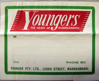
Label, Youngers, Early 20th century
John Younger came to Warrnambool from Yackandandah in 1888 originally with a partner John Jeffrey and opened a store selling general merchandise. In 1914 a new company known as Younger PTY LTD. was formed. The business grew into a large department store in Liebig Street. In 1958 the business was sold to Charles Moore and continued trading as Youngers. The store closed in 1980This label is an important memento of one of the key businesses in Liebig Street, Warrnambool in the 20th century. Younger stores are credited with making Liebig Street the main street in this city.White paper label with red and green printing adhered to a piece of grey cardboard. There is another label on the same card.Youngers THE HEART OF WARRNAMBOOL YOUNGER PTY. LTD.,LIEBIG STREET,WARRNAMBOOL M date 'PHONE 8021 youngers warrnambool -
 Ringwood and District Historical Society
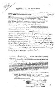
Land Purchase Document, Land Purchase for Samuel George Isaacs of Elizabeth Street, Melbourne for 148 acres, 2 roods and 9 perches in County of Mornington Parish of Ringwood - 1858, Feb-1858
1598 laminated copy on cardboard of Victoria - Land Purchase for Samuel George Isaacs of Elizabeth Street, Melbourne for 148 acres, 2 roods and 9 perches in County of Mornington Parish of Ringwood for the sum of 148 pounds 11 shillings and two pence. +Additional Keywords: Isaacs, Samuel Georgeas above -
 Ringwood and District Historical Society
Land Titles Documents, Titles Department, Documents of land transfer 1911and Certificate of title for land in Pitt Street Ringwood 1920 plus list of names of transferees, 1911 -1920
Photocopies of transfer of land 1920 (poor quality) 1 copy A3, 1 A4. Certificate of title 1920, A4 and list of transferees for land in Bedford Road and Pitt Street Ringwood +Additional Keywords: Walker, E.E Thomas,A / E Thomas,A / Wisemann, A. / Edelsten, E / Unsworth,M -
 Kew Historical Society Inc
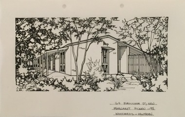
Drawing - Property Illustration, Margaret Picken, 164 Brougham Street, Kew, 1995
After training as a Cartographic Draftsman within the mining industry, I worked as a property illustrator for real estate firms in the eastern suburbs of Melbourne for 23 years from 1983. I initially photographed houses with a Polaroid camera and made a 'thumbnail' sketch while there. The photos were used to scale off a sketch in pencil and then that sketch was overlaid with drafting film and the 'pen and ink' completed. The pens I used were the Rotring ‘Rapidigraph’ drafting pens. The ink was also made by Rotring (German).The film was ‘Rapidraw’, polyester drafting film, double matte. It takes a very fine line and doesn’t bleed. As well as house sketches, there were often floor plans and site plans ordered. Aerial sketches were ordered when the property needed an overall view. (Margaret Picken, 2020)This drawing is one of a series created by Margaret Picken for a range of real estate agents in Melbourne between c.1983 and c.2005. Each work is signed and dated by the artist.Gift of Margaret Picken, 2020Built by Merchant Builders to a design by Gunn Hayball, Terry Dorrough, Merchant Design Pty Ltd. The design used was Modern Merchant Builders Long House LG3 clifton grey brick. This pen and ink drawing on drafting film of 164 Brougham Street was made by by Margaret Picken in 1995.164 BROUGHAM ST., KEW / MARGARET PICKEN '95 / WOODARDS ~ HAWTHORNartist -- margaret picken 1950-, architectural drawings -- houses -- kew (vic.), 164 brougham street -- kew (vic.) -
 Greensborough Historical Society
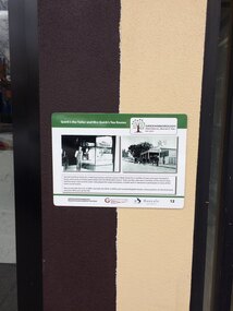
Photograph - Digital Image, Chris Foster, Quirk the tailor and Mrs Quirk's tearoom, Greensborough (Main Street Plaques Project), 17/05/2018
In 2018, Greensborough Historical Society placed plaques in the Main Street area of Greensborough. In these photographs, GHS member Chris Foster, accompanied by GHS President Noel Withers, has photographed the installation of the 'Quirk the Tailor and Mrs Quirk's Tearoom' plaque on Main Street Greensborough. The Main Street Plaques Project placed historical information about original Greensborough buildings as close to the original site as possible. Further information available on the GHS website. The Plaques were made possible through a Greensborough RSL Grant.Digital copy of 2 colour photographs.main street plaques project, main street greensborough, quirk family -
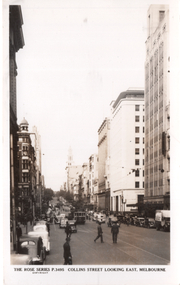 Melbourne Tram Museum
Postcard, Rose Stereograph Co, "Collins Street Looking East Melbourne", c1950
Rose Series postcard No. P 3495 titled "Collins Street Looking East Melbourne" from west of Elizabeth Steet Has a W2 class tram at the Elizabeth Street stop. On the right is the newly completed Royal Bank chamber, completed in 1941, and the MLC buliding. Yields information about Collins St from near Queen St looking east. 1940'sPostcard - printed real photograph with Rose Stereograph Co. name on the rear. Unused.trams, tramways, w2 class, collins st, elizabeth st -
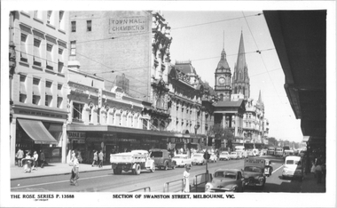 Melbourne Tram Museum
Postcard, Rose Stereograph Co, "Section of Swanston Street Melbourne", mid 1950s
Rose Series postcard No. P 13588, titled "Section of Swanston Street Melbourne", looking south from Bourke Street with the Town Hall in the background with two trams alongside. Has the safety zone for the northbound track in the view. Many Holden based cars are in the view.Yields information about Swanston St mid 1950sPostcard - printed real photograph with Rose Stereograph Co. name on the rear.trams, swanston st, town hall, holden, tramways -
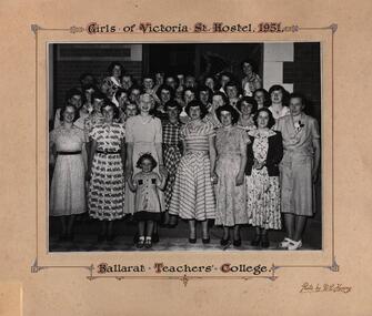 Federation University Historical Collection
Photograph - Black and White, Ballarat Teachers' College: Girls of Victoria Street Hostel, 1951, 1951
!30 Victoria Street Ballarat was built for Joseph Phillips in 1888. It was originally named "Ellaville". It was a family home until it was sold to the Education Department in 1945/46 and became a hostel for young ladies, later becoming a residence for the Ballarat Teachers' College. When Ballarat Institute of Advanced Education and the Ballarat Teachers' College merged in 1976, the Victoria Street residence became availablefor use by the Ballarat School of Mines. Today 130 Victoria Street is used as a student residential facility attached to Federation University.Black and white photograph mounted on beige card. Photo information written in black with brown and blue highlightsPhotographers namevictoria street ballarat, joseph phillips, "ellaville", education department, hostel, ballarat teachers' college, ballarat institute of advanced education, ballarat school of mines, federation university, women -
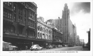 Melbourne Tram Museum
Postcard, Rose Stereograph Co, "Swanston Street, showing Manchester Unity Building, Melbourne", late 1940s
Rose Series postcard No. P 1718, titled "Swanston Street, showing Manchester Unity Building, Melbourne", Photo looking north along Swanston Street from Flinders Lane. Has a one W2 class, one W5 class and one W4 class tramcar in view. The Manchester Unity Building, Capital Theater and the Century Building all dominate the streetscape between Collins and Little Collins Streets. The Champion Building on left of the photo was built around 1923 and demolished around 1972. Yields information about an aerial view of Melbourne late 1930sPostcard - printed real photograph with Rose Stereograph Co. name on the rear.tramways, trams, swanston st, manchester unity building, w2 class, w5 class, w4 class -
 Eltham District Historical Society Inc
Photograph, From left: Unknown, Mario Fabbro and possibly Helen Skipper, Bell Street, Eltham
At Bell Street, Fabbro Farm, Eltham; From left: Unknown, Mario Fabbro and possibly Helen Skipper, standing in the middle of a vegetable crop. The site of the Fabbro farm (Diamond Creek side land) is now called Barrack Bushlands. It is doubtful that Fabbro's farm holding was ever called Barrak Park, This title is fairly recent after the Shire of Eltham purchased the land, including the last section in 1993/94. About this time the area on the west side of Falkiner Street was purchased by a private developer and developed as housing. The area in Bell Street opposite the Eltham High School was purchased by the State Government is recent years and is called Fabbro Fields. The Fabbro Family operated their farm in Bell Street, Eltham. 1 black and white photographfabbro's farm, bell street, eltham, maurice fabbro, farming, helen skipper, vegetables -
 Eltham District Historical Society Inc
Photograph, Fabbro's farm, Bell Street, Eltham, c.1990s
Fabbro's farm and house, Bell Street, Eltham, c.1990s. A crop of artichokes were planted on the farm at this time. The site of the Fabbro farm (Diamond Creek side land) is now called Barrack Bushlands. It is doubtful that Fabbro's farm holding was ever called Barrak Park, This title is fairly recent after the Shire of Eltham purchased the land, including the last section in 1993/94. About this time the area on the west side of Falkiner Street was purchased by a private developer and developed as housing. The area in Bell Street opposite the Eltham High School was purchased by the State Government is recent years and is called Fabbro Fields. The Fabbro Family operated their farm in Bell Street, Eltham. 1 colour photograph printed with white borderfabbro's farm, bell street, eltham, artichokes, barak farm -
 Eltham District Historical Society Inc
Photograph, Artichokes growing at Bell Street, Eltham, c.1990s
Fabbro's farm and house, Bell Street, Eltham, c.1990s. A crop of artichokes were planted on the farm at this time. The site of the Fabbro farm (Diamond Creek side land) is now called Barrack Bushlands. It is doubtful that Fabbro's farm holding was ever called Barrak Park, This title is fairly recent after the Shire of Eltham purchased the land, including the last section in 1993/94. About this time the area on the west side of Falkiner Street was purchased by a private developer and developed as housing. The area in Bell Street opposite the Eltham High School was purchased by the State Government is recent years and is called Fabbro Fields. The Fabbro Family operated their farm in Bell Street, Eltham. 1 colour photograph printed with white borderfabbro's farm, bell street, eltham, artichokes, barak farm -
 Eltham District Historical Society Inc
Photograph, Maurice Fabbro with artichokes growing at Bell Street, Eltham, c.1990s. Maurie is in his 70s
Fabbro's farm and house, Bell Street, Eltham, c.1990s. A crop of artichokes were planted on the farm at this time. The site of the Fabbro farm (Diamond Creek side land) is now called Barrack Bushlands. It is doubtful that Fabbro's farm holding was ever called Barrak Park, This title is fairly recent after the Shire of Eltham purchased the land, including the last section in 1993/94. About this time the area on the west side of Falkiner Street was purchased by a private developer and developed as housing. The area in Bell Street opposite the Eltham High School was purchased by the State Government is recent years and is called Fabbro Fields. The Fabbro Family operated their farm in Bell Street, Eltham. 1 colour photograph printed with white borderfabbro's farm, bell street, eltham, artichokes, barak farm, maurice fabbro -
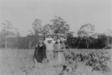
 Eltham District Historical Society Inc
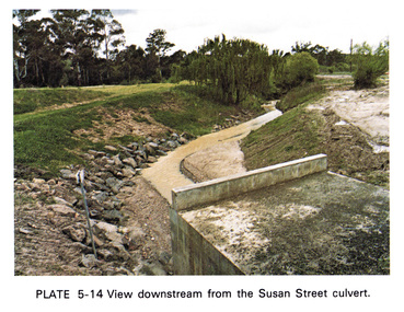
Work on paper (Sub-Item) - Photograph, View downstream from the Susan Street culvert
Colour photograph of the view downstream from the Susan Street culvert, Elthameltham, susan street, culvert, drain, channel -
 Eltham District Historical Society Inc
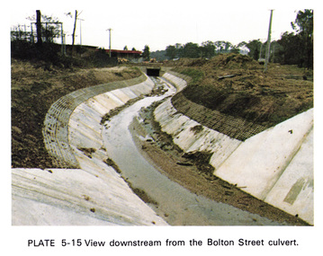
Work on paper (Sub-Item) - Photograph, View downstream from the Bolton Street culvert
Colour photograph of the view downstream from the Bolton Street culvert, Elthameltham, channel, concrete, drain, bolton street -
 Eltham District Historical Society Inc
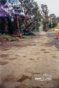
Photograph, Looking west along Brougham Street, Eltham, c.1988, 1988c
Road construction works on Brougham Street prior to sealing, outside No. 21.Colour photographbrougham street, eltham, road construction, streets -
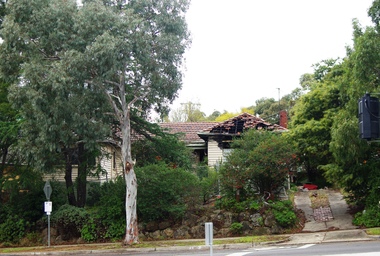 Greensborough Historical Society
Photograph - Digital Image, Marilyn Smith, Corner of Flintoff and Grimshaw Street Greensborough, 18/06/2018
3 views of a fire damaged property at 4 Flintoff Street GreensboroughDigital colour photographsgrimshaw street greensborough, flintoff street greensborough -
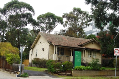 Greensborough Historical Society
Photograph - Digital Image, Marilyn Smith, The Practice, 16 Flintoff Street Greensborough, 18/06/2018
Views of The Practice, 16 Flintoff Street Greensborough, a specialist psychology practice.Digital colour photographsflintoff street greensborough, the practice greensborough -
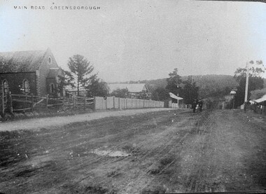 Greensborough Historical Society
Photograph - Digital Image, Methodist Church, Main Street Greensborough c1910s, 1910s
A view of Main Street Greensborough showing the Methodist Church, taken in the 1930s.Digital copy of black and white photograph.main street greensborough, methodist church greensborough -
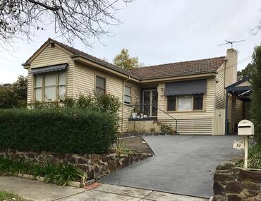 Greensborough Historical Society
Photograph - Digital Image, 51 Adeline Street Greensborough, 2000c
House at 51 Adeline Street Greensborough, formerly the home of the Collyer familyDigital colour photographadeline street greensborough, collyer family -
 Greensborough Historical Society
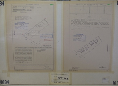
Planning Document, Subdivision Plan #1034. 50 Hume Street, 03/02/1982
Plan of Strata Subdivision at 50 Hume Street Greensborough for 7 units.An example of hard copy subdivision plans from the Greensborough area. Mainly from the Shire of Diamond Valley era (1964-1994).Plan (2 sheets) mounted on heavy card.Stamped and handwritten Council permissions, dates and other details.subdivision plan -
 Greensborough Historical Society
Photograph - Digital image, Collins family, Chapman Street Macleod 1957. The Collins family, 1956-1957
6 digital photos of the construction of the Collins home in Chapman Street Macleod.6 digital photographs, black and whitecollins family, graeme collins, lorraine collins, chapman street macleod -
 Greensborough Historical Society
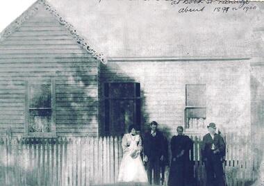
Photograph - Digital image, Medhurst family at Booth Street Bendigo, circa 1899, 1899c
This photograph shows four people outside a house in Booth Street Bendigo.Digital copy of black and white photograph.medhurst -
 Greensborough Historical Society
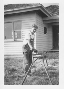
Photograph - Digital image, 23 Mayfield Street Greensborough, 1959, 1959_
Photograph of man and dog at front of 23 Mayfield Street Greensborough in 1959.Digital copy of black and white photograph.mayfield street -
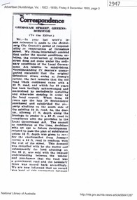 Greensborough Historical Society
Newspaper Clipping, Grimshaw Street Greensborough (to the editor) 1935, 06/12/1935
Deals with the matter of Council responsibility for the construction and maintenance of Grimshaw Street GreensboroughReprint of a letter to the Editor by D. Medhurst from Hurstbridge Advertiser Friday 6 December 1935 p. 5. Printed from Trove.grimshaw street greensborough, david medhurst