Showing 10954 items matching " land"
-
 Bendigo Historical Society Inc.
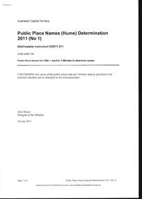
Document - PUBLIC PLACE NAMES (HUME) DETERMINATION 2011, 20 July 2011
Document, Public Place Names (Hume) Determination 2011 (No1) PPN Act 1989. I Determine the names of the public places that are Territory land as specified in the attached schedule and as indicated on the associated plan, Signed John Meyer, Delegate of the Minister 20 July 2011. Pethard Road in Hume was approved on 08 August 2011. Many thanks to Kay MacGregor for her help in the research of the Pethard Family Page 4 Pethard Family Research, Page 5 Division of Hume where Pethard Road is situated. Included is a map showing Pethard Road coloured In .Authorised by the ACT Parliamentary Counsel.document, names of bendigo pioneers, george pethard -
 Bendigo Historical Society Inc.
Document - CAMBRIDGE PRESS COLLECTION: CHEQUE - NUTTAL CLARK
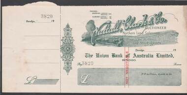
Cheque with cheque butt attached. Nuttall, Clark & Co. is printed at an angle across the top. Underneath is Auctioneer, Northern Land Salesmen and Live Stock Agents. Under the name is a rural scene with cattle drinking from a creek , some sheep in a paddock and a two log rail fence. On the other side of the fence are stacks of hay and two men loading the sheaves onto a horse drawn wagon. Date line ends in 19- -. Decorative work on the left side. 3820 stamped after Pay. Printed in a greyish green with red Not Negotiable in the centre.business, printers, cambridge press, cambridge press collection, nuttall clark & co, the union bank of australia limited bendigo -
 Bendigo Historical Society Inc.
Photograph - VAL CAMPBELL COLLECTION: PHOTOGRAPH OF A LARGE GROUP OF PEOPLE STANDING BESIDE A POOL
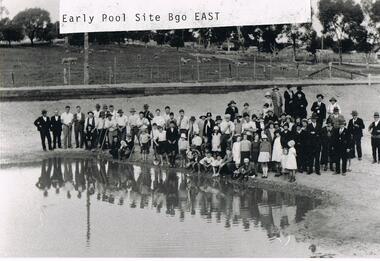
Black and white photo of a large group of people standing beside a pool which has been dug from the surrounding grassed area. The group is a mixture of adults and children. Some of the men are holding long poles and one boy a shovel. In the background sheep are grazing behind a high fence. Written on the front of the photo: Early Pool Site Bgo East. Written on the back of the photo: Bendigo East Pool the Beginning Land was donated to the Committee by Mr Moog who owned large amounts of property in the area. It was then called Moog Park then (not decipherable) then Eastern Park.recreations, sports, swimming -
 Clunes Museum
Document (item) - CERTIFICATE, SUPREME COURT OF VICTORIA, WILLIAM AND SARAH STEART
william steart, sarah jane steart, henry harold steart -
 Ballarat Tramway Museum
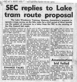
Newspaper, The Courier Ballarat, "SEC replies to Lake Tram route proposal", 14/09/1971 12:00:00 AM
Yields information about the discussions and views of the SEC about operation of historic trams in Ballarat after the closure of the SEC operated system.Newspaper clipping from The Courier, Ballarat, 14/9/1971 about a letter to the City Council from the SEC about the Lake Wendouree Tramway Museum Committee's proposal to operate a tram service on the lake route for a trail period. SEC said that this was not practical and advised that the sheds could only be used to house the trams. Noted that the SEC proposed to sell the land in 1972, and the Council's proposal that certain materials be stored. Quotes Cr. Chisholm (Mayor) and City Engineer (Mr. R. J. Sharp). Image added 20/11/2013In black ink in the top right hand corner of the item - '14/9/71'trams, tramways, museum establishment, btps, depot, city of ballarat -
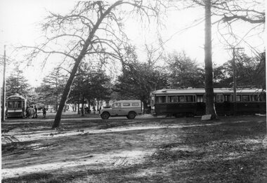 Ballarat Tramway Museum
Photograph - Black & White Photograph/s, The Courier Ballarat, 18/07/1972 12:00:00 AM
Yields information about the relocation of the bogie trams from the old SEC depot to the new BTPS depot in the gardens and partly how it was done.Black and White copy photograph of a newspaper photograph taken by The Courier of the transferring bogie cars to the BTPS depot. No. 38 has been moved across the road, while No. 40 is behind John Withers Land rover. Photo taken 18/7/1972, published 19/7/1972. See Reg. Item 1792 for the photo used in the newspaper clipping. Collected by Alan Bradley from the Ballarat Courier early 1980's. See Excel file "Record of Ballarat Courier Photos BTM era" (Archive Documents) for source of details.tramways, trams, btps, moving trams, depot junction, tram 38, tram 40 -
Kew Historical Society Inc
Archive (series) - Subject File, 'Bella Vista', (aka 'Malinda')
Kew Historical SocietySince its foundation in 1958, members of the Kew Historical Society have been compiling and storing information about subjects relating to the history of Kew and its environs, of which this file is an example.Secondary values'Bella Vista' was a large Federation house built in 1902 which occupied the eastern corner of Thomas Street and Cotham Road. The house was built for Abel Hoadley who died in 1918. In 1937 Augustus Beker opened the property as a guest house named 'Malinda' Guest House. This closed in 1940. In 1941, the land was subdivided into four lots. During the 1940s, Fr. Maas opened a hostel for Dutch Catholic immigrants in the house. The house has now been demolished. The subject file contains an auction notice for the sale of Malinda in 1941 along with correspondence from 2016 detailing background information, a timeline of the demolition of th those, the name of the original owner, and other uses of the house's name.malinda, bella vista, cotham road, fr maas, abel hoadley, anthony heinemannmalinda, bella vista, cotham road, fr maas, abel hoadley, anthony heinemann -
 Kew Historical Society Inc
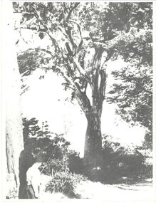
Photograph, 'Canoe Tree', Bowyer Avenue, Kew, 1950-1960
This work forms part of the collection assembled by the historian Dorothy Rogers, that was donated to the Kew Historical Society by her son John Rogers in 2015. The manuscripts, photographs, maps, and documents were sourced by her from both family and local collections or produced as references for her print publications. Many were directly used by Rogers in writing ‘Lovely Old Homes of Kew’ (1961) and 'A History of Kew' (1973), or the numerous articles on local history that she produced for suburban newspapers. Most of the photographs in the collection include detailed annotations in her hand. The Rogers Collection provides a comprehensive insight into the working habits of a historian in the 1960s and 1970s. Together it forms the largest privately-donated collection within the archives of the Kew Historical Society.On the Miller Estate, Myrtle Hill, an immense red gum became known as the 'Canoe Tree' because of the scar in its trunk which was believed to have been caused by the local Indigenous inhabitants of Kew in creating a canoe. Dorothy Rogers (A History of Kew, 1973) records that "the tree, with increasing age became a safety risk, and was at first lopped, but when the land was subdivided some years ago it was removed all together. In Bowyer Avenue, which bears a family name of the Millers, a memorial has been erected which commemorates the tree." There is no date given for its removal.canoe tree, myrtle hill, dorothy rogers, bowyer avenue (kew), first peoples -
 Surrey Hills Historical Society Collection
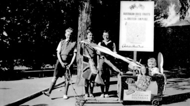
Photograph, Chatham students support the Empire, Surrey Hills, c 1947, 1947
The billycart was possibly decorated for celebrations associated with Empire Day. Image was originally copied by Chatham Primary School for inclusion in their pictorial history "A Patchwork of People - Chatham Past and Present" [ISBN 0 646 29370 2], by Susan Barnett and Julia Ashby, published in 1996 for the school's 70th anniversary. Copied for the SHNCHC with the school and donor's permission. There is also a laminated copy of it for display purposes.Black and white image of four boys and their billycart. Two are identified as Bruce Hansen, standing behind the flag and Jimmy Boyd, seated in the billycart, which is decorated with streamers, an English flag and advertising signs promoting Australian sultanas and the export of Australian dried fruit to the [British] Empire. The photo was taken in the grounds of Chatham Primary School. In the background can be seen some of the cypress trees that were planted along the side of the oval, a remnant eucalypt from the time when the land was part of J B Maling's farm and part of the shelter shed.chatham primary school, billycarts, advertising signs, empire day, bruce hansen, jimmy boyd -
 Kilmore Historical Society
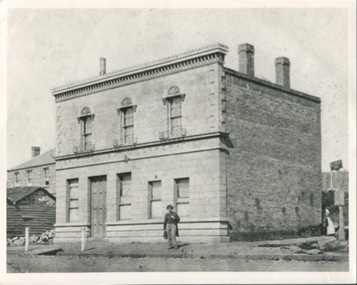
Photograph, Oriental Bank Corporation, 1866
This photograph was most likely taken for the 1866 Intercolonial Exhibition in Melbourne.25cm x 20cm black and white reproduction of a photograph of the Oriental Bank Corporation, 7 Sydney Street Kilmore, from the State Library of Victoria. Double storey building with decorative parapet along roofline, wrought iron balconets at upper storey windows, decorative hood molds above windows, name of bank in stone under ground floor cornice, a man standing on path in front of bank. Woman standing at back of building in shadow. A sign on post at back of building reads: Land for Sale Apply to W. Grace Solicitor Kilmore.Printed on back: REPRODUCTION RIGHTS RESERVED Copied by State Library of Victoria Tenders called for erection of this building in March 1864.banks, 19th century -
![Map, Plan of Town Allotments Bacchus Marsh [1891-1897]](/media/collectors/5e461d8021ea67224c82f2a1/items/66acc1c90c778f9f64a3daec/item-media/66acc3990c778f9f64a3e09b/item-fit-380x285.jpg) Bacchus Marsh & District Historical Society
Bacchus Marsh & District Historical SocietyMap, Plan of Town Allotments Bacchus Marsh [1891-1897]
This plan of town allotments in Lerderderg Street and Bennett Street also includes the location of many of the buildings, shops, businesses and houses which were present in the retail and business area of Bacchus Marsh in the 1890s. The precise date of the plan is not known but it must be sometime between 1891 and 1897. The Post Office and the Wesleyan Church are both shown on this plan. Both of these were constructed in 1890. The plan does not show the Baptist Church in Main Street which was constructed in 1898. Hence the date is sometime between 1891 and 1897.This plan of Bacchus Marsh is one of the most detailed visual representations of the location of shops, businesses and houses in the central part of Bacchus Marsh. It provides very precise locations of most of the shops and houses in the town in the 1890s. A single page paper plan showing allotments of land fronting Lerderderg and Bennett Street. Buildings, businesses and houses along most of the streets are identified by hand written annotations. Streets identified on plan: Lerderderg Street - Bennett Street - Main Street - Gell Street - Young Street - Graham Street. Physical boundaries of the map are: North border - Lerderderg Street - South border - Main Street - West border Gell Street - East border - Young Street. The plan is pasted into a bound volume containing 76 maps or plans in total. bacchus marsh victoria maps, shops bacchus marsh -
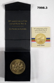 Bendigo Military Museum
Memorabilia - COMMEMORATIVE MEDALLION, Australian Government, Department of Veterans' Affairs, Office of Australian War Graves, 2005
Part of the Cooper Collection.1. Gold coloured metal medallion. The obverse features the Australian Coat of Arms with text "WORLD WAR II, SERVICE TO AUSTRALIA. The reverse symbolises land (Army) Sea (Navy) and Air (RAAF) on a stylized map of Australia. Text "WORLD WAR II, 60 YEARS, 1945-2005". 2. Black coloured cardboard box with hinged lid and magnetic catch. Navy blue felt covered insert to fit medallion. Gold coloured text on top of and inside of box. 3. Four page insert with text. 4. Commemorative certificate with text.2. Printed in gold on cover: 'Australian Government, Department of Veterans Affairs.' Australian Coat of Arms above text. Printed on inside of bar in gold text: "60th Anniversary of the end of World War II, for Services to Australia." 3. cooper collection, ww2, memorabilia, commemorative medallion -
 Bendigo Historical Society Inc.
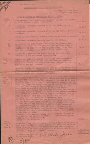
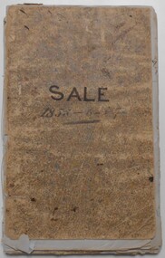
Document - MISS G ALICE JONES COLLECTION: ACCOUNT
The Liquidator. Bendigo amalgamated Goldfields Ltd. To Miss G. Alice Jones. Re Sale of Lands by Auction on 11 Aug. 1938. Pink paper with dates, July 4, 5, 6, 7, 15-21, 23, Aug 4 to 9, Oct 20 to 1938 to Apl 2 1939, Oct 20 to Nov 15, 1939, and 19 August 1941. Account for work involved in sale of land, transfer, letters, and problems of some purchasers refusing to sign. Total cost £18. 1. 0. R702 posted 19/8/41.the miss g alice jones collection - account, bendigo amalgamated goldfields ltd., j. h. curnow & sons, k murdoch, bendigo a 1 co., state land tax office, n bear, o'halloran, rooney, power, huxtable, gray, mcwilliams, eaglehawk municipality, municipality of bendigo -
 Bendigo Historical Society Inc.
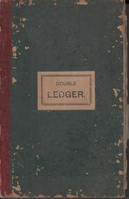
Administrative record - Bendigo Tailings Company N.L Double Ledger, 1912 - 1913
'A communication from Mr. A.T. Balaam asking that the Central Board of Health be communicated with on the subject of arsenical fumes from the furnaces of the Bendigo Tailings Company at Quarry Hill, where pyrites are to be treated, was also referred to the Mayor.' Bendigo Independent, City Council, p9. 31st May 1913. 'Tenders are invited by the Bendigo Tailings Company for the purchase of two complete cyanide plants, first class assay plants, stores and equipment. Full details may be obtained from the Manager, Mr. J.J. Stanistreet.' Bendigo Independent, p4, 3rd March. 1916.Dark green hard dover book, maroon binding on spine. One hundred and sixty six pages of which ninety three are used. On front cover, white label with 'Double Ledger' printed in black. On front page, a purple stamp: ' Bendigo Tailings Company, No Liability' Alphabetical index in front of book detailing names and pages of transactions. Example for 'L' entry: lease rents; Langdon S.J.; Lansell G.V., L.N. and E; land. Entries in book date from 1912 - 1913. Ledger forms part of the Margaret Roberts Collection of Mining records.bendigo, margaret roberts, , goldmining, bendigo tailings co. n.l., mccoll rankin and stanistreet, arsenic -
 Bendigo Historical Society Inc.
Document - LANDS OFFICE: SANDHURST AND DISTRICT CROWN LAND SOLD BY AUCTION 1854
Document: booklet, brown paper cover secured by string on spine. Written on front cover ' copy of sale books, January 16, 17. 18, 19, 26 1854. Harcourt, Lockwood, Muckleford' Blue lined pages with copy of advertisement for town lots for auction. LH page columns: price per acre, amount, deposit. RH page balance, purchaser, name, residence. White sticker fixed to pocket: Book 4 Sandhurst Land Sales, including outlying areas 16 January 1854 to 19 January 1854.lands office, bendigo, sandhurst, harcourt, muckleford, lockwood, land sales, auctions -
 Bendigo Historical Society Inc.
Document - LANDS OFFICE: SANDHURST AND DISTRICT LAND SALES BY PUBLIC AUCTION 1855 - 1857
Document: booklet, marbled cardboard cover. Written on front ' Sale 1855 - ?7' Inside front cover £50 per acre - 6/3 per rood. £8 do. 1/- do, V1 do. -/1/2 do. 'E' ' from April 30th. 1855 to Jany. 27th. 1857' Contains blue pages with red columns. Copies of Crown Lands Sales listed in book, to right of copy, deposit, name of purchaser and total amount. White sticker on pocket Sandhurst Land Sales 22 January 1855 to 27 January 1857Lands Officebendigo, land sales, lands office, crown land, land sales, auctions, sandhurst -
 Bacchus Marsh & District Historical Society
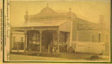
Photograph, Pearce Brothers Store Main Street Bacchus Marsh 1883
This store was built in 1881 and opened as a branch of Pearce Brothers main store which was further along in Main Street, Bacchus Marsh. The store in this image opened around early June 1881 and was described in the Bacchus Marsh Express as "quite above the usual standard of stores in towns of a similar or even much larger size. The building is most substantially built of brick, and measures 58 feet by 26 feet, with walls fourteen feet high inside. The interior is most elaborately fitted with shelves and glass cases covering both side walls and two ends formed by small offices separated from the main store by glass and wood panelled partitions, with a passage way between to the storeroom at the rear", Express, (Bacchus Marsh, 11 June, 1881, page 2). The building was designed by one of its proprietors T. G. Pearce and was entirely constructed by local contractors and workers.Small sepia unframed photograph on card with gold border framing photograph. Housed in the album, 'Photographs of Bacchus Marsh and District in 1883 by Stevenson and McNicoll'. The image depicts a general store with a double-front of windows. Goods such as spades, shovels, tubs and wringers are arrayed on the footpath in front of the store. At the front of the shop under a verandah stands a man, possibly one of the Pearce brothers who owned this business. Next to the store is a vacant block of land with a white picket fence. A sign erected above the fence advertises: “ Pearce Bros. Chaff. Hay & Oats. Produce. Dealer. “On the front: Stevenson & McNicoll. Photo. 108 Elizabeth St. Melbourne. COPIES CAN BE OBTAINED AT ANY TIME. On the back: LIGHT & TRUTH inscribed on a banner surmounted by a representation of the rising sun. Copies of this Portrait can be had at any time by sending the Name and Post Office Money Order or Stamps for the amount of order to STEVENSON & McNICOLL LATE BENSON & STEVENSON, Photographers. 108 Elizabeth Street, MELBOURNE. pearce family bacchus marsh, general stores bacchus marsh, shops bacchus marsh, pearce brothers general store bacchus marsh, stevenson and mcnicoll 1883 photographs of bacchus marsh and district -
 Melbourne Tram Museum
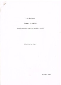
Document - Report, Melbourne & Metropolitan Tramways Board (MMTB)?, Ministry of Transport?, "East Burwood Tramway Extension - Middleborough Road to Vermont South - Feasibility Study, Oct. 1981
Report - 43 pages, photocopied, stapled in top left hand corner - titled "East Burwood Tramway Extension - Middleborough Road to Vermon South - Feasibility Study - October 1981". No details as who made the report, assumed Ministry of Transport or MMTB. Gives details of proposals considered, population and land use, existing services, patronage, operating costs, revenue and provides an assessment. Looks at costs for an extension only to Blackburn Road, Springvale Road and to Vermont South. Report showed the cost benefit ratio for Blackburn Road was 1, and less for the other possibilities.trams, tramways, east burwood, feasibility study, new tramway, mmtb, middleborough rd, vermont south -
 Melbourne Tram Museum
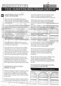
Document - Report, Minister of Transport, "Bringing history back to life - The Hawthorn Tram Depot", Aug. 1998
Report - consultation document titled - "Bringing history back to life - The Hawthorn Tram Depot", 7 A4 sheets, photocopied, outlining the joint Public Transport Corporation (PTC) and Urban Land Corporation (ULC) study into the future of the Hawthorn Tram Depot. Includes a site plan or location map, consultation proposals, news release from the Minister for Transport - Mr Robin Cooper - dated 12/8/1998 and background document providing details of some of the heritage trams - both the PTC and the TMSV. Two copies held - one stapled. Imaged as a pdf file.trams, tramways, hawthorn depot, heritage, minister for transport, tram depot -
 Warrnambool and District Historical Society Inc.
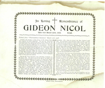
Document - Obituary Gideon Nicol, 2014
Gideon Nicol (1836-1908) was a seaman who came to Warrnambool in 1858. In 1865 he selected land at Mount Warrnambool. He was one of the founders of the Farnham Cheese and Butter Factory and the Garvoc Cheese and Butter Factory and was a Warrnambool Shire Councillor from 1879 to 1906. This scan will be useful to include in the Gideon Nicol fileThis is an A4 sheet of paper (scan). The obituary is printed in black and white with an ornate border with some discoloration on the outer edges.In Loving Remembrance of Gideon Nicol who died March 20th 1908, R.I.P. (an extract from the Warrnambool Standard follows)gideon nicol, warrnambool, gideon nicol obituary -
Eltham District Historical Society Inc
Document - Folder, McMahon, Andrew
An interview with Andrew McMahon, who was completing his Ph.D. on fire ecology, describing past major fires and fire programs. Contents Newspaper article: "Land of fire", Diamond Valley News, 12 April, 1983, Andrew McMahon was completing a Ph.D. on fire ecology. Newspaper clippings, A4 photocopies, etc -
 Mission to Seafarers Victoria
Print - Reproduction, Wilbraham Frederick Evelyn Liardet, View of the North Shore, Port of Melbourne, 1862
Liardet, W. F. E. (Wilbraham Frederick Evelyn), 1799-1878 depicts the busy port of Melbourne showing many types of ships and the Bethel Church built in 1860 on the Custom House land. The church replaced the Bethel ship which sank in February 1860.This watercolour along with the Francois Cogne print from 1863, "Sandridge from Hobson's Bay, and the engraving "A Bird's-eye View Of Melbourne From Sandridge" dating from 1882, is a rare depiction fo the Bethel church. In 1887, the church was demolished to erect the building still standing on the corner of Nott Street and Beach Road.wilbraham liardet, sandridge, port, ships, port melbourne, hobsons bay, bethel church, reverend kerr johnston, 1812-1887, missions to seamen, 1862, customs house -
 Greensborough Historical Society
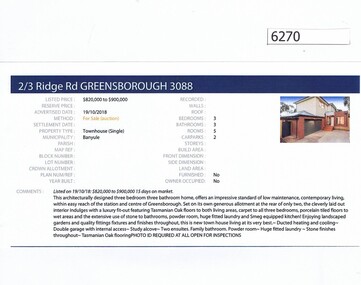
Advertising Leaflet, Barry Plant Greensborough, 2/3 Ridge Road Greensborough, 19/10/2018
Real estate advertisement for 2/3 Ridge Road Greensborough, a 3 bedroom townhouse. This house was sold on 14/12/2018 for $850,000. Previous sales: January 2017 for $800,000. 3 Ridge Road (vacant land) was sold 19/05/2012 for $390,000.Real estate advertisement black text and colour photographridge road greensborough -
![Photograph - Digital Image, Johannes Adem Bosch [John Adam Bush], 1910c](/media/collectors/4f729f5697f83e03086015b8/items/5441c12a2162f10c081edebc/item-media/5441c15c2162f10c081ee01a/item-fit-380x285.jpg) Greensborough Historical Society
Greensborough Historical SocietyPhotograph - Digital Image, Johannes Adem Bosch [John Adam Bush], 1910c
Photograph of Johannes Bosch cropped from larger photograph. Johannes Bosch and family migrated from Southern Germany to Greensborough district c1889. They farmed along the Plenty River having purchased land from Flintoff. They later changed their surname from Bosch to Bush.Digital copy cropped from black and white photograph.johannes bosch, john adam bush, bosch family, bush family -
 Halls Gap & Grampians Historical Society
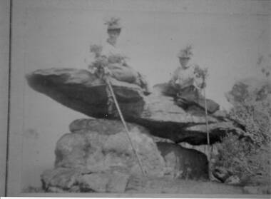
Photograph - Sepia
The name " Balmain " has been attributed to the photo, James Balmain and his wife, Amy Sophia [D'Alton} purchased a vacant school cottage from the area and moved it to their land and called it Bellfield. Amy died at age 37, James returned to Scotland with their 3 children.Photo shows 2 women sitting on a rock formation, both are wearing hats adorned with flowers and appear to be wearing long skirts and high buttoned blouses. They are both holding sticks which seem to be decorated with flowers,recreation, bush-walking -
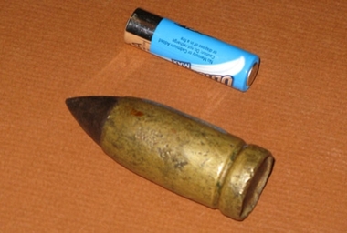 Friends of the Cerberus Inc
Nordenfelt 1 inch Projectile
One inch Nordenfelt machine guns were used on board vessels of the Victorian Navy to combat the torpedo boats. One inch, as opposed to the .45 inch, Nordenfelt guns used by the Land Forces could penetrate the boilers of torpedo boats and thereby stop them.none -
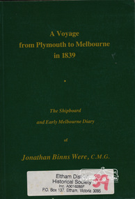 Eltham District Historical Society Inc
Book, A voyage from Plymouth to Melbourne in 1839 : the shipboard and early Melbourne diary of Jonathan Binns Were, 1964
J B Were was associated with Henry Dendy. Were Street, Montmorency possibly named for Were. "Were's were importers, exporters, and agents for shipping, land, cattle, sheep and wool. In 1851 they became brokers and buyers of gold, and in 1853 began to deal in shares." - ADB Hardback, no dust jacket; xv, 309 p. : ill., facsim., geneal. tables (folded), maps, ports. ; 20 cm.ISBN 0646002287ship voyage, early settlers, plymouth england, melbourne -
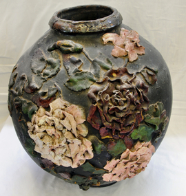 Orbost & District Historical Society
ginger jar, Pre 1893 floods in Orbost
In the early days of Orbost many Chinese were engaged in land clearing or had arrived when gold was discovered in East Gippsland in the 1840's. They lived in camps along the Marlo Road and houses were usually built on stilts. They left after the 1893 floods.This object has aesthetic appeal. It is an object which belonged to the very early settlement days of Orbost.Huge, ornate Chinese ginger jar. Four raised hand- painted pink roses on front. Jar itself is matt black. Looks more like a vase than a ginger jar. Ceramic.Some Chinese writing to left hand side of roses.ceramics, ginger jar, container - domestic, vase -
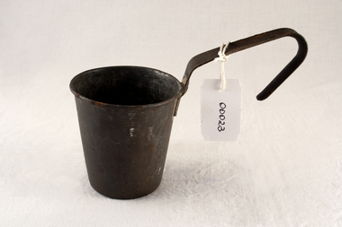 City of Moorabbin Historical Society (Operating the Box Cottage Museum)
Functional object - Kitchen equipment, water-dipper, c1920
Early settlers could only obtain clean water by sinking a well on their land. A pump was built to draw water for use by the family and this tin dipper would have been used for drinking water. The Lachlan Mackinnon family were early settlers in Moorabbin ShireEarly settlers had to sink wells on their land and build water pumps in order to obtain water. This tin dipper would have been used for drinking at the water pump . In 1846 Lachlan and Charles Mackinnon bought 117 acres of land in the 'Dendy's Special Survey' from J.B.Were This area is now known as the suburb of 'McKinnon' and may have been named after them.A tin water-dipper for obtaining drinking water from water pumpmoorabbin, wells, water supply, pioneers, ormond, bentleigh, mckinnon, market gardeners, early settlers, kitchen equipment, water pumps, mackinnon jessie, mackinnon donald, mackinnon lachlan, mackinnon charles, mackinnon daniel -
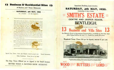 City of Moorabbin Historical Society (Operating the Box Cottage Museum)
Flyer - Smith Estate, Bentleigh, 1935
This Land was owned by one the pioneers of Bentleigh Mr John Logan Smith (1860-1932), who owned J. L. Smith Hay & Grain Store, on the corner of Jasper and Centre Road, Bentleigh. The family sold the property after Mr Smith passed away.Example of the progress of the Municipality of MoorabbinAdvertising flyer for auction of real estate sales - plan of building blocks for sale - PhotocopySmith's Estate, Bentleigh 13 Home Sites and 13 Business Sites Auction Saturday 4 may 1935 - W. H.Wood, T. A. Butters, H. Lordjohn logan smith, centre road, jasper road, bentleigh, aution, real estate