Showing 10395 items
matching plan
-
 Bendigo Historical Society Inc.
Map - CAMPBELL COLLECTION: BENDIGO AND DISTRICT MAPS, 15-2-29
Map. Nerring, Parish of Nerring, scale 20 chains to 1 inch. Prepared in W.J.B. from A and B plans by W.J. Galbraith 15-2-29. (number 356 in map cupboard 1)W.J.Galbraithmap, bendigo, parish plan -
Bendigo Historical Society Inc.
Programme - 125th Anniversary, March 1998
Strathfieldsaye State School (SS 1211) began in the Shire Hall in March 1873. Five acres was gazetted in January 1874 and a three roomed, weatherboard school building opened in January 1875.Stathfieldsaye Primary School 125th Anniversary programme and tour guide. 1873 to 1998. The six pages includes a song called Pathways to the future by Gail Godber; a programme; history of the school and a plan of the school.history, bendigo, strathfieldaye primary school, back to celebrations 125th anniversary, gail godber -
 Bendigo Historical Society Inc.
Map - BENDIGO GOLDFIELDS MAP
Map of the Bendigo Goldfield, showing reef lines, mines and significant geographical features such as Monument Hill, Quartz Hill and Diamond Hill. On the back of map 'Department of Mines, Victoria. Plan of Bendigo Goldfield.bendigo, mining, bendigo goldfields -
Bendigo Historical Society Inc.
Document - NEW CHUM LINE OF REEF - SKETCH OF MINES ALONG THE NEW CHUM LINE OF REEF
Sketch of mines along part of the New Chum Line Of Reef. Sheet No 1 (179). Caleb Thomas Jan 28th 1879. Plan. Hercules and Energetic Mines on drawing, 430 feet apart.document, gold, new chum line of reef, new chum line of reef, sketch of mines along the new chum line of reef, hercules, energetic, caleb thomas -
 Bendigo Historical Society Inc.
Document - BILL ASHMAN COLLECTION: CORRESPONDENCE
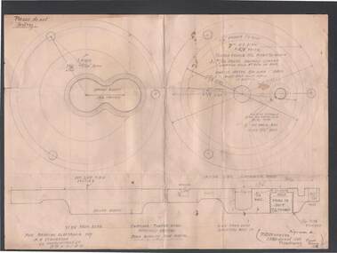
Pencil drawing of end plates for S.B. for Bendigo Electronic Coy, F. A. Stevenson, 62 Honeysuckle St., Bendigo. Reference 23 Birdwood Ave, Dandenong.Detailed drawing of plan and side.elevation of S. B.sciences, instruments - general, scalebuoy, bill ashman collection - correspondence, s b bronze h/? end plates, bendigo electronic coy, f a stevenson, p r stevenson -
 Bendigo Historical Society Inc.
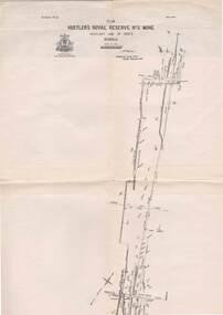
Map - STRUGNELL COLLECTION: HUSTLER'S LINE OF REEFS, BENDIGO, September 1913
Map, Hustler's Line of Reefs, Hustler's Royal Reserve No.2 Mine, Bendigo Plan. Plate No.V1 (6). Bulletin No 33 Signed H.A.Whitelaw Underground survey Office Bendigo September 1913Underground Survey Office, Bendigo.map, bendigo, hustler's royal reserve no. 2 mine* -
Bendigo Historical Society Inc.
Map - CAMPBELL COLLECTION: BENDIGO AND DISTRICT MAPS
Map. Forest Commission Victoria, Bendigo Forest District, Basic information prepared 1982, scale 1:100,000. Fire Prevention Strategy Plan. Mitiamo, Greater Bendigo Area, Castlemaine F.D.map, bendigo, forest district -
Port Melbourne Historical & Preservation Society
Map - MMBW, Oct 1894
Melbourne and Metropolitan Board of Works 1894 Plan No. 10 Segements shown: 363, 367 and 368 Large scale (40'=1") Swallow Street to Railway Place, Railway pier to mid railyards"Copywrited 14.1.95" written in red ink "311/H"engineering - board of works, business and traders - hotels, transport - railways, transport - tramways -
Port Melbourne Historical & Preservation Society
Document - Photocopy, Land sale brochure, Dot Wharrie, 1987
Either copies of or the brochure itself was in Dot WHARRIE's possession, and she made these copies to be put into a heritage exhibition staged by Pat GRAINGER at the Missions to Seamen building, Community Day Dec. 1987. They show portions of brochure offering various lots including site later J.E. Earl's and Morley's Coal Store (at the time leased by S&A). Lots 6 to 11 are the only ones included on these pages. All properties were owned by Lady Janet CLARKE.One of two yellow photocopies of allotment plans and descriptions from sale brochure c1905: property belonging to Lady Janet CLARKE, Rouse, Bay and Beach Streets plus Post Office PlaceInk notes on back with guesses as to date, signature 'Pat Grainger'business and traders, built environment, town planning, heritage, dot wharrie, moule hamilton and kiddle, swallow & ariell ltd, morley's coal depot, lady janet clarke, land sales -
 Bendigo Historical Society Inc.
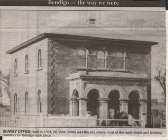
Newspaper - JENNY FOLEY COLLECTION: SURVEY OFFICE
Bendigo Advertiser "The way we were" from 1999. Survey Office: built in 1854, 60 View Streeet was the site where most of the early street and buiolding planning for Bendigo took place.newspaper, bendigo advertiser, the way we were -
 Bendigo Historical Society Inc.
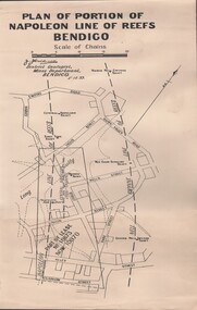
Document - MCCOLL, RANKIN AND STANISTREET COLLECTION: NAPOLEON REEF GOLD MINING CO. N.L, 5 December 1939
Document: 4 Copies of plans showing part of lease No. 10970 (was 10873) and Central Napoleon Lode Channel, prepared by J.J. Caldwell District Geologist, Mines Dept, Bendigo 5th Dec 1939.organization, business, industrial - mining, mccoll rankin & stanistreet, mining, gold mining, napoleon reef -
Clunes Museum
Map, 1890
Features location of Club Hotel, Union Bank, Engine rooms, Port Phillip Hotel, Pyrites furnace, Battery, Office, Smith Shop,Surface Tramway to BatteryPhotocopy of map/plan of Dixon's New North Clunes, Central Clunes Co. and South Clunes utd showing various shafts and pre-emptive rights. Scale 1 inch = 100 feetOn front in red ink; "drawn in 1890"mine shafts, hotels, plans -
Clunes Museum
Letter - NEWSLETTER
.1 MARCH 1999. A MESSAGE FROM THE PRINCIPAL. A NEWSLETTER ABOUT THE PLANNING AND THE REASON TO BUILD A CAMPUS IN CLUNES ON THE UNITING CHURCH PROPERTY .2 A NEWSPAPER CUTTING ABOUT BUILDING A LEARNING VILLAGE IN CLUNESwesley college, clunes campus -
Tatura Irrigation & Wartime Camps Museum
Folder - autobiography, Bert Whitmore, 14 July 1989
an insight into the history and events of camp 14 as narrated by 90 year old Bert Whitmore.A clear plastic cover with a dark blue margin with white strip on which is written "Loveday internment camp 14 - Bert Whitmores Memoirs". The front page has a plan of internment camp 14.Loveday internment camp 14 - Bert Whitmores Memoirsloveday, south australia, bert whitmore, internee memoirs, camp 14 -
Stawell Historical Society Inc
Accessory - Costume and Accessories, c1912
White Cotton Shift with Lace Yoke Waist plan Hem 9cm Wide Lace Rose Pattern Forming Yoke Trimmed with Rose Leaf Patterned Square Neck. Inserts of lace in Bodice. stawell clothing material -
Whitehorse Historical Society Inc.
Letter - Correspondence, Obtaining a grant of Crown Land at rear of Myrtle Grove, 1932
Correspondence between Council and Closer Settlement Board re land in Pakenham Street including plans of allotments.Correspondence between Council and Closer Settlement Board re land in Pakenham Street including plans of allotments. Also further correspondence re land being sold by Malcolm Sheehan to Dal Hear.Correspondence between Council and Closer Settlement Board re land in Pakenham Street including plans of allotments.pakenham street, blackburn, myrtle grove, blackburn, shire of blackburn and mitcham, sheehan, malcolm, hearn, dal, victoria. closer settlement board -
 Whitehorse Historical Society Inc.
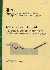
Document, Land under threat, 1981
'Land under threat: the future use of public open space adjoining Blackburn Creek' by Blackburn Creek Conservation Group, November 1981.'Land under threat: the future use of public open space adjoining Blackburn Creek' by Blackburn Creek Conservation Group, November 1981. Includes detailed descriptions, plans, bird lists, correspondence.'Land under threat: the future use of public open space adjoining Blackburn Creek' by Blackburn Creek Conservation Group, November 1981.blackburn creek, parks and reserves, kalang park, furness park, environment, blackburn creek conservation group, blacks walk, blackburn creeklands, melbourne and metropolitan board of works, city of nunawading, burgess, graham -
 Whitehorse Historical Society Inc.
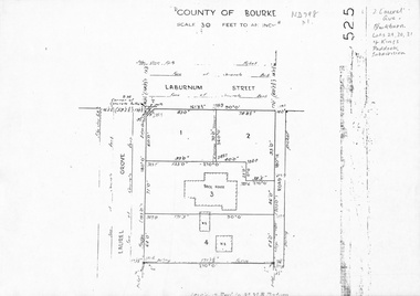
Map, Laurel Grove, 1959
Plan of subdivision, part of Crown Portion 84, Lots 29, 30, 31 Kings Paddock subdivision, cnr Laurel Grove and Laburnum Street, Blackburn. Ref 2713, 6/2/1959.laurel grove, blackburn, laburnum street, land subdivision, kings paddock -
 Bendigo Historical Society Inc.
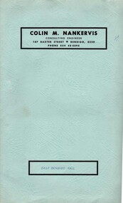
Document - BERT GRAHAM COLLECTION: EAST BENDIGO HALL
Document, Bert Graham Collection, East Bendigo Hall, Colin M.Nankervis, Consulting Engineer, 107 Baxter Street, Bendigo 3550. Phone 054 430095. Plans for extending the East Bendigo Hall.bendigo, clubs, bendigo east progress association -
Bendigo Historical Society Inc.
Document - LYDIA CHANCELLOR COLLECTION: BENDIGO METHODIST CHURCH CIRCUITS PLAN OF SERVICES 1962-63, 1962-1963
LYDIA CHANCELLOR COLLECTION: Bendigo Methodist Church Circuits Plan of Services November, december, January 1962-63 Forest Street Mackenzie Street Arnold Street Golden Square Quarry Hillbendigo, history, bendigo churches -
Bendigo Historical Society Inc.
Pamphlet - LYDIA CHANCELLOR COLLECTION: BENDIGO METHODIST CIRCUITS PLAN OF SERVICES 1964-65, 1964-65
LYDIA CHANCELLOR COLLECTION: Bendigo Methodist Circuits Plan of Services 1964-65 For Forest St, Mackkenzie St, Arnold St, Golden Square, Quarry Hill, officials, timetables and financial report.bendigo, history, churches -
 Ballarat Tramway Museum
Map, Ken McCarthy, Map of Proposed National Park Line - SPER, mid 1950's
Hand drawn plan on plain foolscap paper of proposed tram line from Loftus to View Point within National Park for South Pacific Electric Railways - with notes, proposed destination roll.trams, tramways, sper, national park line, loftus, destination roll -
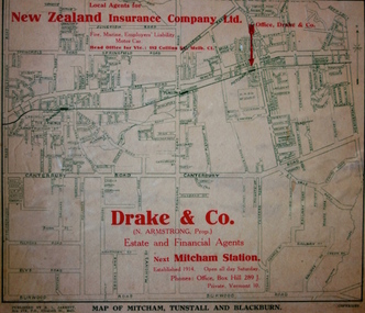 Kew Historical Society Inc
Map - Street Map, R L Jarrett, Map of Mitcham, Tunstall and Blackburn, 1929
Tunstall was originally the name of Nunawading Railway Station. Tunstall opened on 4 June 1888 and was renamed on 1 November 1945. An historically significant advertising map that can be used to ascertain the extent of urban development in 1929 in the areas of Nunawading, Blackburn and Mitcham.A map of Mitcham, Tunstall and Blackburn found on the reverse of a real estate subdivision plan published by R. L. Jarrett of Elizabeth Street. This promotional street map is overprinted with the business address of the sponsors and advertising. Map overlaid in red print: "Drake & Co. / (N. Armstrong, Prop.) / Estate and Financial Agents / next Mitcham Station / Established 1914. Open all day Saturday. / Phones: Office, Box Hill 289 J. / Private, Vermont 10."real estate agents, mitcham, tunstall, blackburn, road maps, drake & co, new zealand insurance co ltd -
University of Melbourne, Burnley Campus Archives
Work on paper (item) - Student Work, Luke Flanagan, Marriott Residence Landscape Design, 2016
Submitted as an assignment for HORT90035, 'Landscape Construction and Graphics,' coordinated by Andrew Laidlaw. assignment, landscape construction and graphics, landscaping, hort90035, burnley horticultural college -
Canterbury History Group
Ephemera - "Haslemere" 137 Mont Albert Road, Canterbury, 1997
Real estate advertisement for auction of "Haslemere" (c1889) 137 Mont Albert Road Canterbury, on 22nd November 1997. Includes coloured photographs of exterior and interior, architectural features, and floor and site planscanterbury, mont albert road, fireplaces, lead lights, victorian style, jellis craig and company, haslemere -
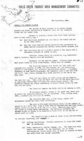 Falls Creek Historical Society
Document - Circular To Licence Holders & Others Interested In Committee Plans, 05.09.1963
Bob (Herman) Hymans (a former member of the Royal Netherlands Navy) was born in Bloemendaal, Holland on 30th September 1922. During World War II he fought against the Japanese in the Dutch East Indies (now Indonesia) and was imprisoned in Changi and on the Burma Railway. After gaining qualifications as a Ski Instructor, Bob arrived in Falls Creek in July 1950. Working as an Instructor and Supervisor at Bogong Lodge, Bob decided his future was in accommodation. He was successful in negotiating an indenture for land from the State Electricity Commission (SEC). It took Bob two years to build his Grand Coeur Chalet but, tragically, it was burned down in August 1961. Bob also built the first Chairlift in Australia. This was a single chairlift and the structure was built from wooden electricity poles. He was constantly full of new ideas and proposals for the village. Bob Hymans die on 7th July 2007. This Collection of documents and letters tells the story of Bob's endeavours to develop Falls Creek into the ski village it is today.This letter is significant because it documents developments made or endorsed by the Falls Creek Tourist Area Management Committee.A circular from the Management Committee outlining their plans for the development of the Falls Creek Tourist Area. This included completion of the Gully Chairlift, earmarking sites for cafes and restaurants and improvement in public facilities and medical services.falls creek tourist area management committee, falls creek administration -
 St Patrick's Old Collegians Association (SPOCA)
Photograph - SPOCA, Tour of Ireland
-
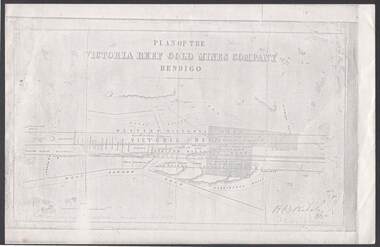 Bendigo Historical Society Inc.
Document - VICTORIA REEF GOLD MINES COMPANY BENDIGO PLAN
Photocopy of a Plan of the Victoria Reef Gold Mines Company, Bendigo. Shaded area is the Victoria Reef Gold Mines Company Lease No. 2 and Lease No. 3. The gullies are named Happy Valley, Long, Derwent, Providence and Ironbark Gullies. The reefs are: Western Victoria, Victoria, Eastern Victoria and Prince Albert Reef. Between the Eastern Victoria Reef and the Prince Albert Reef is the White Lead. Mount Korong Road is at the bottom of the plan. Other Leaseholders are: Burrows, Wybrant, Ballerstedt, Jackson,Roberts & Co, Ashley, Grant, ?rpe, ?eau, Woodward, Coath, Taylor, Cranshaw, Roberts, Gould & Co, Midway, Witscheibe, Endeavour Co, Albert Co, Ballerstedt & Son, Late Iron Bark Quartz Mining Co, McDougall, Specimen Hill Co, Hygrect?, Wheadon, Evans and Bannerman. Signed by H. B. Nicholas. Location of Ballerstedt, Luffsman, Midway Co, Witscheibe and Rae & Co engine locations. Hills are shown as hatch shading. Written at the bottom left ocrner is: Accompanying prospectus issued in Nov. 1859. Signed H.B. Nicholas.plan, bendigo, victoria reef gold mines company, victoria reef gold mines company bendigo - plan, h b nicholas, burrows, wybrant, ballerstedt, jackson, roberts & co, ashley, grant, ?rpe, ?eau, woodward, coath, taylor, cra-shaw, roberts, gou-d & co, midway, witscheibe, endeavour co, albert co, ballerstedt & son, late iron bark quartz mining co, mcdougall, specimen hill co, hyo?, wheadon, evans, bannerman. -
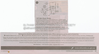 Eltham District Historical Society Inc
Document - Property Binder, 1307 Main Road, Eltham
Newspaper notice: Diamond Valley Leader, 31 January 2018, Calls for submissions re removal of reserve status and rezoning, Reserve 1 on Plan of Subdivision 213452R, Certificate of Title Volume 9879 Folio 829 and Reserve 2 on Plan of Subdivision 134133 Certificate of Title Volume 09434 Folio 620.main road, eltham, property -
 Melbourne Legacy
Document - Minutes, Minutes of meeting of Steering Committee (Future of Residences)
Minutes of the meeting held on 20 June 1974 to discuss the in-depth study authorised by the Board of Management. Items considered included the development of plans, forward planning, and funding of the project to look at options for Blamey House, Stanhope and Harelands. See also Cat Nos. 01689 and 01690. Further investigations were called for. Gives an insight into Legacy thinking about the way in which the residences should be used.White foolscap photocopy, with black type. Two holes punched for filing. Double sided.Page 2: 'L/tee H.C.G. Rodgers' hand written in blue biro.residences, review, blamey house, harelands, stanhope