Showing 10832 items
matching maps
-
 The 5th/6th Battalion Royal Victoria Regiment Historical Collection
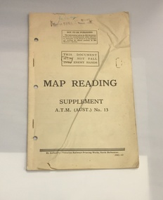
Booklet - Book, Map Reading No. 13 1942, 1942
Military guide to map readingBook made of yellowed paper with black print. It is bound by two staples and has three holes punched into the left side for storage in a ring binder. There is a crease that runs from the bottom left to the top right of the cover.wark vc club, military manuals, ww2, regimental property -
 Marysville & District Historical Society
Book - Hardcover book, Picturesque Atlas Publishing Company Limited, The Picturesque Atlas of Australasia-Volume 3, 1886
The Picturesque Atlas of Australasia-Volume 3Hardcover. Cover is brown with the title in gold lettering. Underneath the title is a symbol of a solid wreath surrounding the head of a ram. A fold-out map is included; Railway Postal and Telegraph Map of the North Island of New Zealand, 1889. non-fictionThe Picturesque Atlas of Australasia-Volume 3atlas, australasia, history -
 Bendigo Historical Society Inc.
Map - CAMPBELL COLLECTION: BENDIGO AND DISTRICT MAPS
Map. Eaglehawk, Parishes of Huntly and Nerring. Scale 20 chains to 1 inch. Total area 6211 acres. Eaglehawk Kerang Railway, to Epsom 2 miles. Manure Depot. (number 390 in map cupboard 1)map, bendigo, allotments -
Bendigo Historical Society Inc.
Map - CAMPBELL COLLECTION: BENDIGO AND DISTRICT MAPS, 9-4-29
Map. Campaspe, Parish of Kimbolton, Scale 20 chains to 1 inch. Total area 4117 acres, Campaspe River, Prepared in W.P.B. by W.J.Galbraith from Parish and Assessment Plans. (number 384 in map cupboard 1)W.J.Galbraithmap, bendigo, agricultural lands -
Bendigo Historical Society Inc.
Map - CAMPBELL COLLECTION: BENDIGO & DISTRICT MAPS, 14-6-29
Map. Eppalock, Sedgwick and Strathfieldsaye. Scale 20 chains to 1 inch. Total area 3972 acres. Prepared in W.P.B. from Assessment Plan and Parish Plans. H.A. Darby. (number 378 in map cupboard 1)H.A.Darbymap, bendigo, agricultural lands -
Bendigo Historical Society Inc.
Map - BAMAWM : COUNTY OF BENDIGO, 19-8-24
Map. Bamawm, County of Bendigo, Turrumberry, Pannoobamawm, Diggorra, Ballendella, Millewa. Photo-Lithographed at the Department of Lands and Survey, Melbourne by W.J. Butson, 19-8-24, Price 1/-. (number 50 in map cupboard 1)W.J. Butsonmap, bendigo, bamawm -
Bendigo Historical Society Inc.
Map - LOCAL AREA PLANS, See above
Map: Compilation of maps: Town lots Bridgewater dated April 29 1871. Village of Colbinnabbin, dated 5 December 1866, Township of Axedale 1858 (Larritt). Suburban lands Axedale dated April 12 1871map, bendigo, parish plan, bridgewater, colbinnabbin, axedale, suburban lands -
Tatura Irrigation & Wartime Camps Museum
Book - Notebook, 1940
Brown leather bound Notebook, pages are pale blue/grey colour, small black pencil in spine. Page 3 has a black outline and a hand drawn map of Australia in the centre with Australia written across the map.diaries, notebook, max baumann -
Tatura Irrigation & Wartime Camps Museum
Book, The Tatura Secret Radio, 1997
Army Intelligence knew there was a secret radio operating in Tatura No.1 Camp. The inmates were getting the war news direct from Germany. They had to have a strong shortwave receiver, but where was it?White soft cover book with an entrance made with barb wire. The front cover depicts a man with headphones on. A map of Victoria and short history of the book on the back cover. B/W photos, with a map of Tatura No 1 camp.Reg. No. 1870.1 signed "With Best Wishes Laura Nilsen"the tatura secret radio, nilsen h, nilsen l, glover i, camp 1, tatura, ww2 camp 1, books, history, local -
 Whitehorse Historical Society Inc.
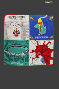
Souvenir - Handkerchief, 1956
Lawn Handkerchief - Memento of Melbourne 1956 Olympic Games. In 4 sections: (1) Map of Melbourne, (2) Picture of Melbourne Cricket Ground, (3) List of Events and Venues, (4) Map of Australia, Olympic flame and kangaroosOlympic Games 22 Nov - 8 Dec 1956civic mementoes, souvenirs -
 Ballarat Tramway Museum
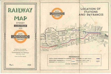
Map, NSWGR, "Railway Map of Sydney Suburban and Underground" - 1939, 1939
Light card or Heavy paper. Colour map showing location of Sydney stations and entrances and where the trains ran. Issued as No.1. Title "Railway Map of Sydney Suburban and Underground" - 1939. Handle with care - both copies.trams, tramways, sydney, railway map, suburban and underground, trams -
 Mont De Lancey
Book, A. H. Massina & Co, A.H. Massina and Co's Weather Almanac and General Guide and Handbook for Victoria for 1894, 1901
A plain red hardcover book - Weather Almanac and General Guide and Handbook for Victoria 1894. A.H.M. & Co's Almanac 1894 - 01. There are maps, calendars, diagrams and general information throughout the book for the guidance of village settlers.A red hardcover Weather Almanac and general Guide and Handbook for Victoria for 1894 - 01 with Calendar and Map of Railway Systems. It has advertisements, tables, calendars, maps, memoranda tables, diagrams and other notes of general interest throughout. non-fictionA plain red hardcover book - Weather Almanac and General Guide and Handbook for Victoria 1894. A.H.M. & Co's Almanac 1894 - 01. There are maps, calendars, diagrams and general information throughout the book for the guidance of village settlers.almanacs, documents, calendars -
Glenelg Shire Council Cultural Collection
Map - Brochure/Map - Great South West Walk, Oct-83
Brochure/map. Great South West Walk. Track notes for the walk on one side, map showing Great South West Walk on the other, white with blue print and images; map multi-coloured. Front of brochure has photo of Shelley Beach, in blue and white, yellow print, yellow GSWW logo. Back cover yellow, black print. Contact details.great south west walk -
Bendigo Historical Society Inc.
Map - CAMPBELL COLLECTION: BENDIGO AND DISTRICT MAPS
Map. Ascot Unit, scale 20 chains to an inch, arrow pointing to magnetic north, road to Fosterville to the East, Huntly 3/4 mile to the West, road to Epsom 3/4 mile and road to Bendigo 4 1/2 miles south west on map, also on page is the Northern Railway (Bendigo to Echuca) line. (number 355 in map cupboard 1)map, bendigo, country lands -
 Melbourne Tram Museum
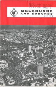
Map, Royal Automobile club of Victoria (RACv), "Melbourne and Suburbs", late 1960's
Map - folded 8 folds or sections, printed in two colours titled "Melbourne and Suburbs", published by the RACV late 1960's, giving a map of Melbourne and its suburbs, shows all tram and rail lines, highways, freeways under construction, has a detailed index and map of the city or CBD area, shows one way streets and churches, clubs etc.On front cover stamped "Office Copy" and hand written date of "28-1-69"trams, tramways, racv, melbourne, map, tramways, timetables -
Glenelg Shire Council Cultural Collection
Administrative record - Cashbook - Ancient Order of Foresters, c. 1878
Cash book, hard cover, green marbled, brown leather binding. Members' contributions and expenses for Court The Hope (Portland), dating from 9 March 1878 - 24 Nov 1914 White label on cover '1878 - 1914'Back: inside back cover - small sketch map of the site of Foresters' Hall in Portland - black ink on white paper -
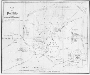 Ringwood and District Historical Society
Photograph, Map of Melbourne & Vicinity - 1853. Survey of Port Phillip. Plan in Bonwick's "Settlement of Port Phillip"
Catalogue card reads, 'Map of Melbourne & Vicinity - 1853. Survey of Port Phillip. Plan in Bonwick's "Settlement of Port Phillip"'. -
Port Melbourne Historical & Preservation Society
Document, Remembering life in Port Melbourne in the good old days, 21 Apr 1988
Recollections of Jack CHUMBLEY of life in Port Melbourne include two-up games, training horses on Sandridge Beach and the introduction of buses to replace the cable trams. A4 copy of newspaper article from the Emerald Hill, Sandridge & St Kilda Times In pencil on top left - Jack knows where the trotting track & 2 up game would be on the map (Terry's dad)jack chumbley -
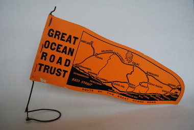 Anglesea and District Historical Society
Pennant, Unknown
Orange pennant flag listing towns on and near the Great Ocean Road. List of town names on pennant - (west to east) Mortlake, Warrnambool, Nirranda, Terang, Port Campbell, Lavers Hill, Colac, Beech Forest, Apollo Bay, Wye, Birregurra, Forrest, Deans Marsh, Peterborough, Princetown, Lorne, Eastern View, Airy's Inlet, Anglesea, Torquay, Geelong, Barwon Heads.GREAT/ OCEAN/ ROAD/ TRUST. Map of Area/ Route of the Great Ocean. (Orange - on wire stand. Printed on both sides.) great ocean road trust -
Tatura Irrigation & Wartime Camps Museum
Photograph, Dhurringile Escape
Copy of map made in Dhurringile POW Camp and carried by Captain Detmers during the tunnel escape by twenty German Officers and men. Map confiscated by the arresting officer at Tallygaroopna, Senior Constable Wilson.german officer pow's, dhurringile escape map, captain detmers, photograph, senior constable wilson -
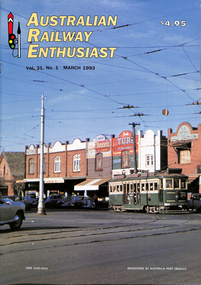 Melbourne Tram Museum
Magazine, Association of Railway Enthusiasts (ARE), "Australian Railway Enthusiast - Vol 31, No. 1, March 1993", Mar. 1993
... Maps ...Magazine - "Australian Railway Enthusiast - Vol 31, No. 1, March 1993", 24 pages, centre stapled, with a front cover colour photo of VR 36, Ormond Road, about to cross the Point Ormond line. Contains a detailed article on both the VR lines by Jim Seletto, featuring photos of 39, 30, 53, 49, MMTB 675 and a colour photo of VR 49 on the rear. Contains maps and diagrams of St Kilda Station. Includes Sandringham and Black Rock line. Published by the ARE.trams, tramways, vr trams, st kilda brighton tramway, sandringham, black rock, maps, st kilda, railways, tram 39, tram 30, tram 53, tram 49, tram 675 -
 Warrnambool and District Historical Society Inc.
Letter Book 4, 1901, 1908
This letter book has letters, invoices, sketch maps and plans and dates from 1908 to 1910. It came from the office of John William Crawley Junior, an engineer, architect and surveyor in private practice in Warrnambool and also the official engineer of the Shire of Warrnambool from 1895 to 1935. His father, brother and son were also engineers and worked in that capacity or as the Shire Secretary for the Shire of Warrnambool, with the Crawley family members recording a total of 132 years of service to the Shire. The letter book was passed on to John Crawley’s son, Rolf, Engineer for the Shire of Warrnambool from 1935 to 1968. The letter book then came into the possession of Michael Hand who took over the private surveying business of Rolf Crawley in Warrnambool and the Warrnambool and District Historical Society has acquired the letter book, one of several Crawley ledgers, from the Michael Hand estate. This letter book is of considerable significance as it contains maps, plans, sketches and written information on the work of John William Crawley, the engineer for the Shire of Warrnambool for 40 years. This is a black-covered letter book with copies of letters and field maps and plans and an alphabetical listing at the front. Some of the letters are invoices for work carried out. The leather section of the front cover has been almost completely torn away and the binding is mended with adhesive tape. There are some torn pages. The front page has a signature and a mauve stamp. ‘Letter Book’ ‘J.Wm. Crawley (Private)’ ‘ Rolf L. Crawley, Civil Engineer, Drainage and Water Supply Engineer, Licensed Surveyor, Registered Architect, Warrnambool’ ‘4’ rolf crawley, warrnambool, john william crawley, junior, warrnambool, history of warrnambool -
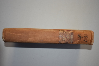 Warrnambool and District Historical Society Inc.
Letter book 7, 1917-1920, 1917
This letter book contains handwritten letters, sketch maps and plans and dates from 1917 to 1920. It comes from the office of John William Crawley Junior, an engineer, architect and surveyor in private practice in Warrnambool and also the engineer for the Shire of Warrnambool from 1895 to 1935. His father, brother and son were also engineers and worked in that capacity or as Shire Secretary for the Shire of Warrnambool, with the Crawley family recording 132 years of service with the Shire of Warrnambool. The Shire existed from 1863 to 1994. The letter book was passed on to John Crawley’s son, Rolf, the engineer for the Shire of Warrnambool from 1935 to 1968. The letter book then came into the possession of Michael Hand who took over the private surveying business of Rolf Crawley in Warrnambool. The Warrnambool and District Historical Society then acquired this letter book, along with other Crawley ledgers, from the Michael Hand estate. This letter book is of considerable significance as it contains letters, plans and maps drawn up John William Crawley Junior, the engineer for the Shire of Warrnambool for 40 years. It will be very useful for research. This is a hard cover book of 745 pages. It has leather trim on the cover edges and the spine with gold lettering on the spine. The leather covering is scuffed and torn. The inside covers have a mottled blue lining. The book contains maps, plans and handwritten letters and has an alphabetical index at the beginning of the book. Most of the pages have been water-stained. ‘7 Private’ ‘Letter Book 1917 to 1920’john william crawley junior, warrnambool, rolf crawley, warrnambool, shire of warrnambool -
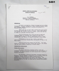 Bendigo Military Museum
Administrative record - Geodetic Survey and Topographical Mapping in Australia - Report by BP Lambert 1968, 1968
Australia is governed by a Federal Government and by six State Governments. National coordination of their respective geodetic survey and topographic mapping activities is effected on the advice of a National Mapping Council. Twenty years ago, at least 95% of Australia was poorly mapped and what maps existed were in need of revision. only a small area of the continent was covered by horizontal geodetic control and there was no scheme for a national levelling survey. Over the intervening period there has been an urgent and increasing demand for topographic maps varying from large scale contoured maps in support of specific engineering projects to rapid reconnaissance maps required for mineral prospecting in remote areas. Superimposed on this has been a defence requirement, specifically for military training areas, and generally for maps of the whole country. During the period much progress has been made. This paper reports on the progress from early colonial days through to the present time and finally hazards a prediction of future trends.Photocopy of 18-page typed report including diagrams, stapled top left-hand corner. Geodetic Survey and Topographic Mapping a Report by BP Lambert Director of National Mapping, Department of National Development, Canberra, Australia, 1968.royal australian survey corps, rasvy, fortuna, army survey regiment, army svy regt, asr, national mapping -
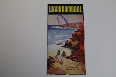 Warrnambool and District Historical Society Inc.
Pamphlet - Tourist Map and Guide, Victorian Railway Commissioners, Warrnambool Victoria Australia, c. 1950
Warrnambool Tourist Map and Guide.1 This is a single sheet of paper folded twice to make a pamphlet. It has a multi-coloured map (predominantly yellow), an illustration, several black and white photographs, printed text and coloured headings. .2 This is a single sheet of paper inserted into item 1. It is folded twice and contains black and white photographs.non-fictionWarrnambool Tourist Map and Guidetourism in warrnambool, warrnambool rail, warrnambool tourist guides -
 Bendigo Historical Society Inc.
Document - MCCOLL, RANKIN AND STANISTREET COLLECTION: INDENTURE GOLD MINING LEASE NO. 11145 CROWN AND NORTH DEBORAH MINING COMPANY, 14th February, 1941
6 page document plus map : Gold mining lease No. 11145 between Crown ( King George VI) and North Deborah Mining Company, Parish of Sandhurst, dated 14th February, 1941. Map: Lease No. 11145 'Mining District of Bendigo, County of Bendigo, Parish of Sandhurst. Total area 48 acres, 3 roods, 22 perches. Map has extensive colour key indicating depths below surface that will be mined. Crown land and surface excised shown in orange cross-hatching. Lease holdings on map: 10753, 11020, 1363 T.L., 1115 T.L., 11013, 11062, 11033, 9988. Dam shown on 11013. Railway line marked through centre of map. Map refers to central area of Bendigo and includes reference to Hargreaves Street, Violet Street, Lily Street, Breen Street and Sullivan Street.bendigo, mining, north deborah mining company, breen street, lilly street, hargreaves street, voilet street, sullivan street. -
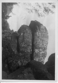 Halls Gap & Grampians Historical Society
Photograph - B/W, C 1940s -- 50s
Rock formation is called " The Woolpacks " and was located on the Wonderland Track at the top of Silent Street -- however on a Broadbent map of the Grampians no.205 this formation was called the " Wool Sacks " ; and the "Woolpacks" was shown on the map close to Venus Bath.Photo shows distinct slabs of rock balancing on each other. Three people appear in the photo -- a man with a boy and a woman. All three are wearing hats. A large rock outcrop can be seen on right of photos -- trees can be seen on left.The Wool Packs F5030scenery, wonderland range -
Tatura Irrigation & Wartime Camps Museum
Map, Irrigation Trust distribution channels
Map retrieved from State Rivers & Water Supply Commission Offices by Gilian Payne. Map of Rodney Irrigation Trust distribution channels, 1887, prepared by Walter Scott Murray. Copied in seven sections. -
 Robin Boyd Foundation
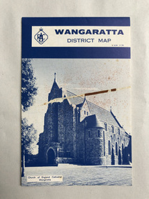
Map, RACV General Insurance, RACV Wangaratta District Map
District Map of Wangaratta and surrounding townshipswangaratta, victoria, map, beechworth, albury-wodonga, walsh st library -
 Creswick Campus Historical Collection - University of Melbourne
Manuscript
These items are notes and maps by K.J SimpfendorferDocuments